Browse Listings
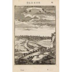
Iedo. (Tokyo)
A late 17th-century miniature view of the skyline of Edo (Tokyo). By Allain Manesson Mallet (1630-1706), a well-traveled military engineer and geographer who worked in 17...
- $200 / ≈ €173
Date: Paris, 1683
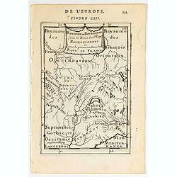
![De l'Europe. [ Figure LXXXV].](/uploads/cache/38452-250x250.jpg)
De l'Europe. [ Figure LXXXV].
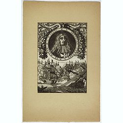
Decorative engraving showing "Ludovicus Magnus" or Louis XIV King of France, Coin Portrait.From the French text edition of "Description d'Univers", 16...
- $50 / ≈ €43
Date: Paris, 1683
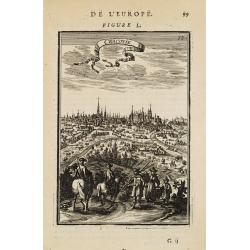
Cracovie.
View of Krakow. From the French text edition of Description d'Univers... By Allain Manesson Mallet (1630-1706), a well-traveled military engineer and geographer who worke...
- $300 / ≈ €259
Date: Paris, 1683
D. Gregoire Caraffe G. M. de Malte. M.C.D.LXXXI.
Portrait of Gregorio Carafa (1615 - 1690), 62nd Prince and Grand Master of the Order of Saint John (Knights of Malta) 1680 until his death in 1690.The sea battle undernea...
- $30 / ≈ €26
Date: Paris, Denys Thierry, 1683
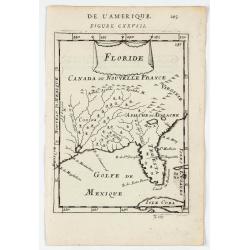
Floride.
A charming map of Florida, also showing Cuba, Golf of Mexico & St Augustine.Title in curtain draped at top. French text on verso.From the original 1683 text edition o...
Date: Paris, 1683
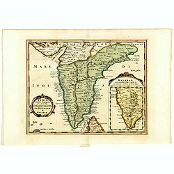
India extra Gangem . . .
Map covering the subcontinent from the Bay of Bengal and the Gulf of Cambay to Ceylon (Sri Lanka) and offers impressive detail given that the interior of India was largel...
- $300 / ≈ €259
Date: Utrecht / Amsterdam, J.Halma, 1683
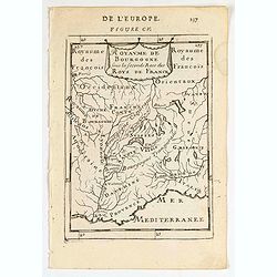
Royaume de Bourgogne sous la seconde race des roys de France.
Map of Bourgogne region.Title in a curtain draped at topFrom the original 1683 text edition of "Description d'Univers. . ." by Allain Manesson Mallet (1630-1706...
Date: Paris, 1683

Indiae extra Gangem Pars Septentrionalis. Indiae extra Gangem Pars Meridionalis.
The map on the left depicts the northern portion of the India Ganges region, representing Burma (Myanmar), Thailand, Cambodia, Vietnam and Laos. The right one depicts th...
Date: Utrecht / Amsterdam, J.Halma, 1683
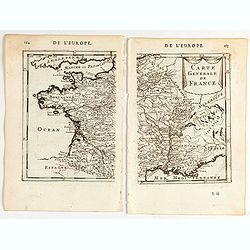
Carte generale de France.
A two-page map of France.Title in curtain draped at top. French text on verso.From the original 1683 text edition of "Description d'Univers. . ." by Allain Mane...
Date: Paris, 1683
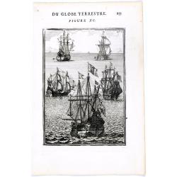
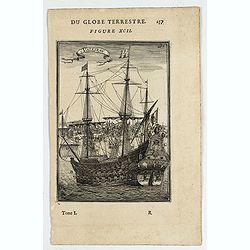
DU GLOBE TERRESTRE - Figure XC. 253
Finely engraved plate of various types of sailing ships.From the French text edition of Description d'Univers.. (5 volumes), 1683. By Allain Manneson Mallet (1630-1706), ...
Date: Paris, 1683
Vaisseau.
Miniature view of a vessel, showing its various corposants. With key list on verso.From the French text edition of Description d'Univers.. (5 volumes), 1683. By Allain Ma...
- $80 / ≈ €69
Date: Paris, 1683
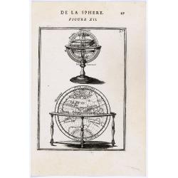
DE LA SPHERE. Figure XII.
A fine 17th century depiction of a floor globe with a turned wooden leg base, the globe displaying an enormous southern continent. Atop this is a wonderful miniature tabl...
- $125 / ≈ €108
Date: Paris, 1683
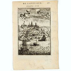
Quebec.
A charming view of Quebec. Title in curtain draped at top. French text on verso.From the original 1683 text edition of "Description d'Univers. . ." by Allain Ma...
Date: Paris, 1683
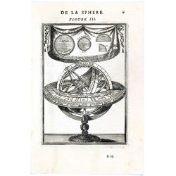
DE LA SPHERE. Figure III. 7
Appealing print focused on an armillary sphere. The latter is surmounted by a cartouche containing some angles in a circle.From the French text edition of Description d'U...
- $150 / ≈ €129
Date: Paris, 1683
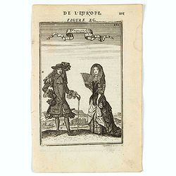
François.
A charming engraving of a French couple in 17th-century dress.Title in a curtain draped at top. French text on verso.From the original 1683 text edition of "Descript...
Date: Paris, 1683
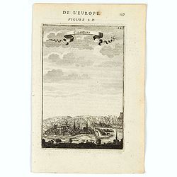
Chamberi.
A charming view of Chambery. Title in a curtain draped at top. French text on verso.From the original 1683 text edition of "Description d'Univers. . ." by Allai...
Date: Paris, 1683
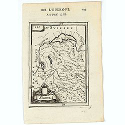
Savoye.
A charming map of Savoy. Title in a curtain draped at top. French text on verso.From the original 1683 text edition of "Description d'Univers. . ." by Allain Ma...
Date: Paris, 1683
![Grande prefecture des Gavels. [de l'Europe / Figure LX] 135](/uploads/cache/38436-250x250.jpg)
Grande prefecture des Gavels. [de l'Europe / Figure LX] 135
A fine and uncommon early 17th-century map of Europe.From the French text edition of "Description d'Univers," 1683. by Allain Manneson Mallet (1630-1706), a wel...
- $30 / ≈ €26
Date: Paris, 1683
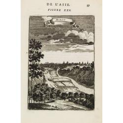
Miaco.
A late 17th-century miniature view of the skyline of Miaco (Kyoto). By Allain Manesson Mallet (1630-1706), a well-traveled military engineer and geographer who worked in ...
- $200 / ≈ €173
Date: Paris, 1683
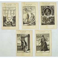
Set of 5 Malta related copper engravings.
Set of 5 Malta-related copper engravings from the French edition of the "Description De L'Univers" by Allain Manesson Mallet. French edition, 1683..By Allain Ma...
- $200 / ≈ €173
Date: Paris, 1683
Malte.
A charming late 17th century French plan of La Valletta. With a ribbon style title cartouche and a nautical sailing ship scene across the top.By Allain Manneson Mallet (1...
- $225 / ≈ €194
Date: Paris, 1683
Isle de Malthe.
A charming late 17th century French map of Malta and Gozo with a large pictorial cartouche depicting Neptune and a mermaid, a nautical sailing ship scene across the botto...
- $250 / ≈ €216
Date: Paris, 1683
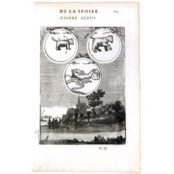
DE LA SPHERE. Figure XXXVII. 103.
Fine celestial map depicting three constellations in allegorical form. The 3 spheres are suspended above an engraved scene of a harbor on a moonlit night.From the French ...
- $100 / ≈ €86
Date: Paris, 1683
![France en general. [de l'Europe / Figure LXVII] 147](/uploads/cache/38437-250x250.jpg)
France en general. [de l'Europe / Figure LXVII] 147
A fine and uncommon early 17th century map of France.From the French text edition of "Description d'Univers", 1683. by Allain Manneson Mallet (1630-1706), a wel...
- $30 / ≈ €26
Date: Paris, 1683
![Carte generale de France. [de l'Europe]](/uploads/cache/38442-250x250.jpg)
Carte generale de France. [de l'Europe]
A fine and uncommon early 17th century map of France printed from two copper plates. Engraved by Liébaux.From the French text edition of "Description d'Univers"...
- $80 / ≈ €69
Date: Paris, 1683
Royaume des… Royaume de Bourgogne sous la race des rois Bourguigons.
Map of Bourgogne region.Title in curtain draped at topFrom the original 1683 text edition of "Description d'Univers. . ." by Allain Manesson Mallet (1630-1706),...
Date: Paris, 1683
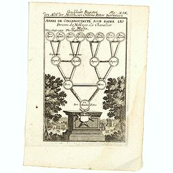
Arbre de Consanguinite Pour Faire Les Preuves de Noblesse de Chevalier de Malte.
An attractive piece that loosely translates to: Tree of Consanguinity To prove of Nobility of Knight of Malta. From Mallet's monumental Description de l' Univers, first p...
- $80 / ≈ €69
Date: Paris, 1683
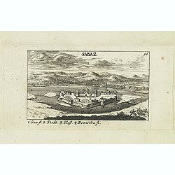
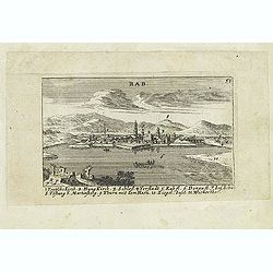
Sabaz. (Sabac)
View of Šabac in western Serbia, along the Sava river.Published in "Der Donau-Strand Mit allen seinen Ein- und Zuflüssen. . .". Published by Jacob Sandrart.
- $75 / ≈ €65
Date: Nuremberg, Jacob Sandrart, 1684

Le Cours de l'Elbe et de l'Oder où sont les Electorats de Saxe et de Brandebourg, les Duchés de Mekelbourg et de Pomeranie. . .
A detailed and scarce map showing the rivers Elbe and Oder in Germany and Poland. Dark engraving.This is one sheet of the four sheet wall map by Pierre Du Val entitled: &...
Date: Paris, 1684
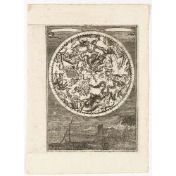
(Celestial) Fig. 36.
A fine celestial map depicting the southern constellations in allegorical form. Fully engraved, it presents a landscape with some sailing ships in the background.From the...
- $200 / ≈ €173
Date: Frankfurt, 1684
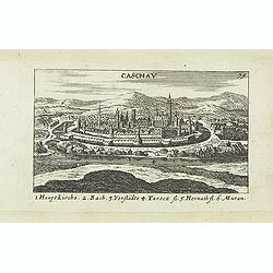
Caschav.
Panoramic view of Caschav (Cassovie). Published in "Der Donau-Strand Mit allen seinen Ein- und Zuflüssen. . .". Published by Jacob Sandrart.
- $100 / ≈ €86
Date: Nuremberg, Jacob Sandrart, 1684
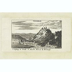
Vicegrad.
Panoramic view of Vicegrad. Published in "Der Donau-Strand Mit allen seinen Ein- und Zuflüssen. . .". Published by Jacob Sandrart.
- $100 / ≈ €86
Date: Nuremberg, Jacob Sandrart, 1684
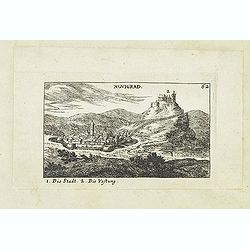
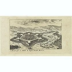
Novigrad.
Panoramic view of Nógrád in northern Hungary. Published in "Der Donau-Strand Mit allen seinen Ein- und Zuflüssen. . .". Published by Jacob Sandrart.
- $150 / ≈ €129
Date: Nuremberg, Jacob Sandrart, 1684
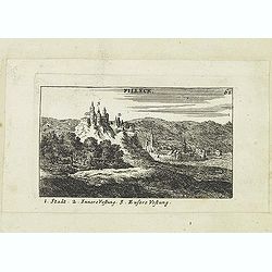
Filleck.
Panoramic view of Filleck (Fuleck, Filakovo). Published in "Der Donau-Strand Mit allen seinen Ein- und Zuflüssen. . .". Published by Jacob Sandrart.
- $150 / ≈ €129
Date: Nuremberg, Jacob Sandrart, 1684
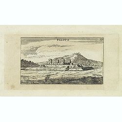
Palota.
Panoramic view of Palota in the Medzilaborce District in the Prešov Region of far north-eastern Slovakia. Published in "Der Donau-Strand Mit allen seinen Ein- und Z...
- $150 / ≈ €129
Date: Nuremberg, Jacob Sandrart, 1684
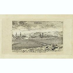
Comora.
Panoramic view of Comora. Published in "Der Donau-Strand Mit allen seinen Ein- und Zuflüssen. . .". Published by Jacob Sandrart.
- $100 / ≈ €86
Date: Nuremberg, Jacob Sandrart, 1684
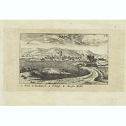
Papa.
Panoramic view of historical city Papa. Published in "Der Donau-Strand Mit allen seinen Ein- und Zuflüssen. . .". Published by Jacob Sandrart.
- $100 / ≈ €86
Date: Nuremberg, Jacob Sandrart, 1684
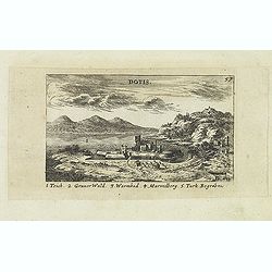
Dotis.
Panoramic view of Dotis (Tata). Published in "Der Donau-Strand Mit allen seinen Ein- und Zuflüssen. . .". Published by Jacob Sandrart.
- $150 / ≈ €129
Date: Nuremberg, Jacob Sandrart, 1684

Novi Belgii novae que Angliae nec non partis Virginiae..
With the arrival of Dutch and other European colonists, the landscape of New Netherland changed dramatically. The third state, with Fort Kassimier and Philadelphia, and ...
Date: Amsterdam, 1684
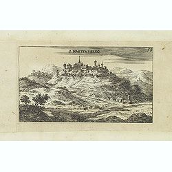
S. Martinsberg.
Panoramic view of S. Martinsberg. Published in "Der Donau-Strand Mit allen seinen Ein- und Zuflüssen. . .". Published by Jacob Sandrart.
- $100 / ≈ €86
Date: Nuremberg, Jacob Sandrart, 1684
Stulweissenburg. (Székesfehérvár)
Panoramic view of Székesfehérvár. Published in "Der Donau-Strand Mit allen seinen Ein- und Zuflüssen. . .". Published by Jacob Sandrart.
- $100 / ≈ €86
Date: Nuremberg, Jacob Sandrart, 1684
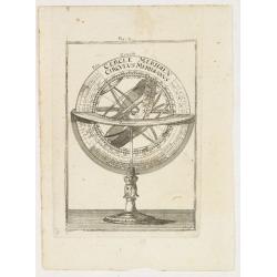
Fig. 4.
Appealing print focused on an armillary sphere.From the German text edition of Description d'Univers.. (5 volumes), 1683. By Allain Manneson Mallet (1630-1706), a well tr...
- $150 / ≈ €129
Date: Frankfurt, 1684

Pas kaart Van Rio Oronoque Golfo De Paria met d'Eylanden Trinidad, Tabago, Granada, Granadillos, en Bequia . . .
A highly detailed and rare sea chart of the mouth of the Orinoco River, Trinidad, Tabago, St.Vincent and neighboring islands. Oriented with north to the right by two comp...
Date: Amsterdam, 1684
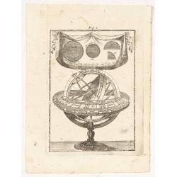
Fig. 3.
Appealing print depicting an armillary sphere.From the German text edition of Description d'Univers.. (5 volumes), 1683. By Allain Manneson Mallet (1630-1706), a well tra...
- $150 / ≈ €129
Date: Frankfurt 1684
![Erla [Eger]](/uploads/cache/30834-250x250.jpg)
Erla [Eger]
Panoramic view of Eger. Published in "Der Donau-Strand Mit allen seinen Ein- und Zuflüssen. . .". Published by Jacob Sandrart.
- $150 / ≈ €129
Date: Nuremberg, Jacob Sandrart, 1684
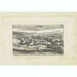
Sigeth.
Panoramic view of Sigeth. Published in "Der Donau-Strand Mit allen seinen Ein- und Zuflüssen. . .". Published by Jacob Sandrart.
Date: Nuremberg, Jacob Sandrart, 1684
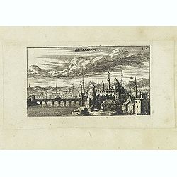
Adrianopel. (Edirne)
Panoramic view of Adrianopel or its modern name Edirne in European Turkey, near the border with Greece and Bulgaria. Published in "Der Donau-Strand Mit allen seinen ...
- $75 / ≈ €65
Date: Nuremberg, Jacob Sandrart, 1684
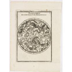
Planisphere des Constellations Meridionalles.
A fine celestial map depicting the southern constellations in allegorical form.From the German text edition of Description d'Univers.. (5 volumes), 1683. By Allain Maness...
- $200 / ≈ €173
Date: Frankfurt, 1684
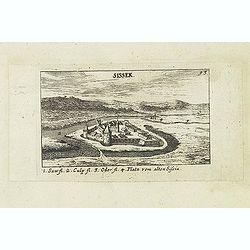
Sissek.
Panoramic view of Sisak in Sisak in central Croatia. Published in "Der Donau-Strand Mit allen seinen Ein- und Zuflüssen. . .". Published by Jacob Sandrart.
- $75 / ≈ €65
Date: Nuremberg, Jacob Sandrart, 1684
Rab. / Leopoldina. / Der Grosse und wunderbare Comet. . .
On recto panoramic view of Raab or Gyor, the Hungarian town on the Danube. On verso a plan of Leopoldina and a view of comet. Published in "Der Donau-Strand Mit alle...
- $90 / ≈ €78
Date: Nuremberg, Jacob Sandrart, 1684
![Fig. 2. [ print depicting three armillary spheres]](/uploads/cache/22626-250x250.jpg)
Fig. 2. [ print depicting three armillary spheres]
Appealing print depicting three armillary spheres.From the German text edition of Description d'Univers.. (5 volumes), 1683. By Allain Manneson Mallet (1630-1706), a well...
- $150 / ≈ €129
Date: Frankfurt, 1684
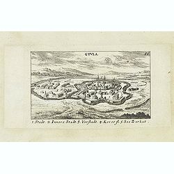
Gyula.
Panoramic view of Gyula in Békés County, Hungary. The town is best known for its Medieval castle and thermal bath. Published in "Der Donau-Strand Mit allen seinen ...
- $75 / ≈ €65
Date: Nuremberg, Jacob Sandrart, 1684
Grant Mogol - Der Graf Mogol (Fig LI).
A fine and uncommon early 17th century print of a Mughal emperor. Engraved by Joh. Jak. Vogel.By Allain Manneson Mallet (1630-1706), a well traveled military engineer and...
- $45 / ≈ €39
Date: Frankfurt, 1684
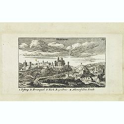
Vesprin.
Panoramic view of Veszprém is one of the oldest urban areas in Hungary, and a city with county rights. It lies approximately 15 km north of the Lake Balaton. Published i...
- $90 / ≈ €78
Date: Nuremberg, Jacob Sandrart, 1684
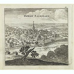
Donau Eschingen. / Der donaü stränd.
Two views pasted on recto and verso of a larger sheet of paper. On recto panoramic view of Donaueschingen a German town in the Black Forest.On verso a map of the Danube a...
- $75 / ≈ €65
Date: Nuremberg, Jacob Sandrart, 1684
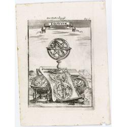
Equateur.
Appealing print centered on an armillary sphere. The latter sits atop a map of the world, which clearly shows California as an island (in reverse — the engraver must ha...
- $125 / ≈ €108
Date: Frankfurt, 1684
S. Nicolaes.
Beautifully etched by Gasper Bouttats (1640-1695) of Szent-Nicolas (Madarsko). Published by Jacques Peeters.
- $150 / ≈ €129
Date: Antwerp, c. 1684

Het Hooge Heemraedtschap van Schielandt.
This beautiful wall map of "Het Hooge Heemraedtschap van Schielandt" is on nine attached leaves (each leaf 49x58,5 cm. ) engraved by J. VINGBOOMS after J.J. STA...
Date: Rotterdam, A. van Hoorn, 1684
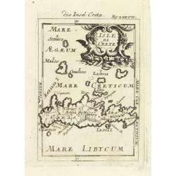
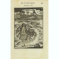
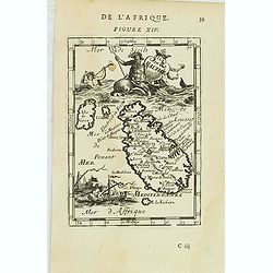
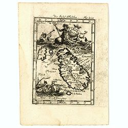
Isle de Crete.
A charming late 17th century map of the Island of Crete. By Allain Manneson Mallet (1630-1706), a well traveled military engineer and geographer who worked in 17th centur...
Date: Frankfurt, 1684
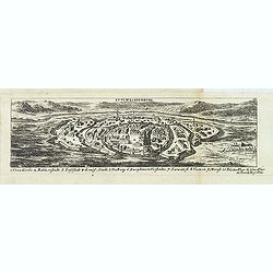
![Weitzen [Vác / Waitzen]](/uploads/cache/30817-250x250.jpg)
Weitzen [Vác / Waitzen]
Panoramic view of Vác / Waitzen with the Donau in the foreground Published in "Der Donau-Strand Mit allen seinen Ein- und Zuflüssen. . .". Published by Jacob ...
- $90 / ≈ €78
Date: Nuremberg, Jacob Sandrart, 1684
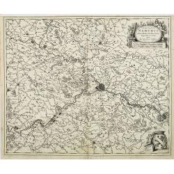
Comitatus Namurci Emendata Delineatio, Nuperrimè in lucem edita, per Nicolaum Visscher.
Detailed engraved map of the province of Namur (Namen), showing cities including Charleroi and Dinant., towns, rivers and lakes. Decorative cartouche with putti. Explanat...
Date: Amsterdam, 1684
Neuhäusl. (Nové Zámky)
Panoramic view of Nové Zámky, in southwestern Slovakia.Published in "Der Donau-Strand Mit allen seinen Ein- und Zuflüssen. . .". Published by Jacob Sandrart.
- $75 / ≈ €65
Date: Nuremberg, Jacob Sandrart, 1684
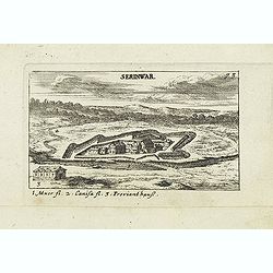
Serinwar. (Zrínyi vár)
Panoramic view of Zrínyi vár in Hungary. Published in "Der Donau-Strand Mit allen seinen Ein- und Zuflüssen. . .". Published by Jacob Sandrart.
- $90 / ≈ €78
Date: Nuremberg, Jacob Sandrart, 1684
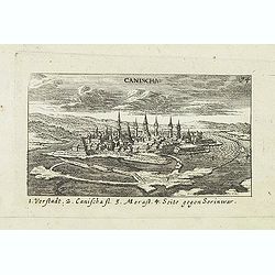
Canischa. (Nagykanizsa / Kanizsa)
Panoramic view of Nagykanizsa / Kanizsa. Published in "Der Donau-Strand Mit allen seinen Ein- und Zuflüssen. . .". Published by Jacob Sandrart.
Date: Nuremberg, Jacob Sandrart, 1684
Zolnok.
Panoramic view of Szolnok (solnok) is the county seat of Jász-Nagykun-Szolnok county in central Hungary. Its location on the banks of the Tisza river, at the heart of th...
- $75 / ≈ €65
Date: Nuremberg, Jacob Sandrart, 1684

Die Mogoler (Fig LIII).
A fine and uncommon early 17th century print of a couple at time of the Mughal Empire. Engraved by Joh. Jak. Vogel.By Allain Manneson Mallet (1630-1706), a well traveled ...
- $40 / ≈ €35
Date: Frankfurt, 1684
Der Grosse Mogol Fig LII.
A fine and uncommon early 17th century print of a Mogol.By Allain Manneson Mallet (1630-1706), a well traveled military engineer and geographer who worked in 17th century...
- $45 / ≈ €39
Date: Frankfurt, 1684
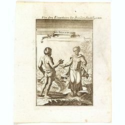
Von den Einwohnerne der Insulen Sonde (Fig LXIII).
A fine and uncommon early 17th century print of two inhabitants of the Sunda Islands, East Indies (Indonesia). Engraved by Joh. Jak. Vogel.By Allain Manneson Mallet (1630...
- $75 / ≈ €65
Date: Frankfurt, 1684
![Ancien Cheva.er de Malte Ein Alter Malthese Ritter Fig: XVI [Together with] D. Gregoire Caraffe G.M. de Malte MDCLXXXI.](/uploads/cache/35860-250x250.jpg)
Ancien Cheva.er de Malte Ein Alter Malthese Ritter Fig: XVI [Together with] D. Gregoire Caraffe G.M. de Malte MDCLXXXI.
Two charming late 17th century engravings of an Knight of Malta and an round portrait of Gregoire Carafa.The copper plate seems during the printing process not well clean...
- $120 / ≈ €104
Date: Frankfurt, 1685
-250x250.jpg)
Lyste vande prysen der goederen ingekoft by de Kamer. . .
Rare price list of meat, bacon, wheat, rye, butter, cheese, olive oil, Spanish wines, Bordeaux, brandy etc.On front page in letter press Lyste Van de Pryfen der Goederen,...
Date: Amsterdam, 1685
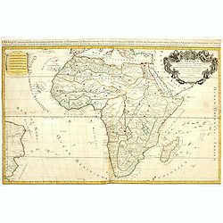
L'Afrique divisée suivant l'estendue de ses principales parties ou sont distingués les vns des autres . . .
A second state of this fine mile-stone map of Africa with a decorative title and scale cartouche. As the title indicates, this map is based on the geography of Guillaume ...
- $750 / ≈ €647
Date: Paris, 1685
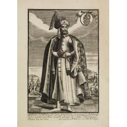
Avrengzebe Roy des Indes Orientales, si zelé po.r. la Religion de Mahomet ..
Very rare and decorative costume plate. Underneath the plate a descriptive text in French.Bears the address : Se vend à Paris chez F. Jollain l aine Rue St Jacques a la ...
Date: Paris, ca. 1685
Isle de Malthe. Die Insul Maltha Fig: XIV.
A charming late 17th century map of Malta and Gozo with a large pictorial cartouche depicting Neptune and a merman, a nautical sailing ship scene across the bottom.The co...
- $250 / ≈ €216
Date: Frankfurt, 1685

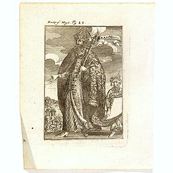
GM de Malte. Der Grossmeister von Malta Fig. XVIII.
Charming late 17th century engraving of grand master of Malta.By Allain Manneson Mallet (1630-1706), a well traveled military engineer and geographer who worked in 17th c...
- $120 / ≈ €104
Date: Frankfurt, 1685
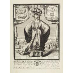
La Reine de la chine.
Very rare and decorative costume plate. In the background : Palais Royal Peking. Beneath the plate a descriptive text about the Queen of China.Bears the address : Se vend...
Date: Paris, ca. 1685
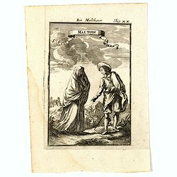
Maltois. Ein Maltheser Fig. XX.
Charming late 17th century engraving of a couple in local dress from Malta.By Allain Manneson Mallet (1630-1706), a well traveled military engineer and geographer who wor...
- $120 / ≈ €104
Date: Frankfurt, 1685
![Amerique Septentrionale divisée en ses principales parties. . .1685. [California as an Island]](/uploads/cache/60628-250x250.jpg)
Amerique Septentrionale divisée en ses principales parties. . .1685. [California as an Island]
Engraved by Cordier. Spectacular example of Jaillot's map of North America, showing California as an Island, based upon Sanson's landmark map of 1656. This map shows the ...
Date: Paris, 1685
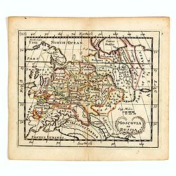
Moscovia or Russia
A rare late seventeenth-century English map of Russia and the Crimea and southern Ukraine, with the northern coast of the Black Sea and its shores. A scarce little map ut...
- $300 / ≈ €259
Date: London, 1685
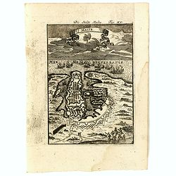
Malte Die Stadt Malta Fig: XV.
A charming late 17th century birds-eye view of Valletta and its fortifications from the southeast with battle ships in the sea. Title scroll in the sky.The copper plate s...
- $250 / ≈ €216
Date: Franckfurt, 1685
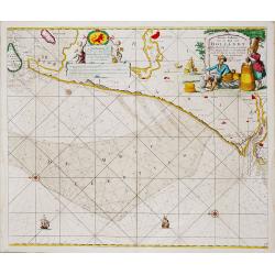
Nieuwe Paskaert van de Kust van HOLLANDT - Tussen Texel en de Maes.
Nieuwe Paskaert van de Kust van Hollandt Tussen Texel en de Maes. A very attractive sea chart off the coast of Holland by Johannes van Keulen with a pair of decorative c...
- $500 / ≈ €432
Date: Amsterdam, ca 1685