Browse Listings in America

Pas-kaart vande Zee kusten van Venecuela met de Byleggende Eylanden. . .
Rare chart of the coast of Venezuela, including the islands of Curaçao, Bonaire, Aruba, etc.The chart has two insets, one (15x22cm) with a map of Curaçao, one smaller w...
Place & Date: Amsterdam, 1680

Mappa Aestivarum Insularum alias Barmudas.
Blaeu based his work on John Speed's remarkably accurate map of 1626-1627. It shows the island divided into tribes and lots, and below the map itself appear the names of ...
Place & Date: Amsterdam, 1635

Carte des Possessions Françoises et Angloises dans le Canada et partie de la Lousiane. . .
Proof state. Here without the decorations around the title cartouche in the what is called in the reference books the first state the cartouche in upper left . No double ...
Place & Date: Paris, 1756

French Line CGT Poster.
French Line CGT Poster showing the Normandie cruise ship travelling from Southampton to New York, advertising an express luxury service on both the Ile de France and the ...
Place & Date: England, ca. 1936

A new map of the English Empire in America. . .
This fine English map of eastern North America including Canada engraved by John Harris and first published by Robert Morden. John Senex acquired and made minor alteratio...
Place & Date: London, 1720

Archipelague du Mexique ou sont les Isles de Cuba..
Scarce map of Caribbean. A visually stunning map with a large title cartouche. This large one-sheet map was produced by the Venetian cosmographer Vincenzo Coronelli when ...
Place & Date: Paris, 1688

Novissima et Accuratissima Totius Americae Descriptio.
Second state of Visscher's map of the Americas, this decorative map greatly influenced the cartography of the Americas both geographically and artistically.Although it di...
Place & Date: Amsterdam, 1677

North Pacific.
Huge three sheet so-called Blue-back sailing chart of the Northern Pacific including China, Korea (with Matu Is. and Liancourt), Japan, Philippines, Kamchatka, Hawaii, Al...
Place & Date: London, 1868

Carte Réduite Des Côtes Orientales De L' Amérique Septentrionale Contenant Partie du Nouveau Jersey.. Virginie.. Georgie..
Uncommon chart that extends from Delaware Bay and Philadelphia south through much of Georgia to Island Amelia and St. Johns River. Fleur-de-lis and rhumb lines fill the s...
Place & Date: Paris, 1778

Carte Réduite Du Golphe Du Mexique Et Des Isles De L' Amérique..
A well engraved and highly detailed chart prepared by Bellin of the Gulf of Mexico and the Caribbean. In addition to a magnificent title cartouche and a color key to the ...
Place & Date: Paris dated year 17, or 1808
![A Toopapaoo of a Chief, with a priest making his offering to the Morai, in Huoheine. [Huaheine - the Society Islands]](/uploads/cache/30045-250x250.jpg)
A Toopapaoo of a Chief, with a priest making his offering to the Morai, in Huoheine. [Huaheine - the Society Islands]
A view of a chief's raised burial chamber in Huaheine, Society Islands, taken from "Views in the South Seas" being a very important and early view depicting sce...
Place & Date: London, Boydell and Co., 1808
![The Coast of New Found Land From Salmon Cove to Cape Bonavista. . . [together with] The Coast of New Found Land from Cape-Raze to Cape St-Francis.](/uploads/cache/40658-250x250.jpg)
The Coast of New Found Land From Salmon Cove to Cape Bonavista. . . [together with] The Coast of New Found Land from Cape-Raze to Cape St-Francis.
Two charts showing the coast of New Found Land from Salmon Cove to Cape Bonavista and from Cape-Raze to Cape St-Francis. With inset chart of Trinity HarborGrierson publis...
Place & Date: Dublin, 1767
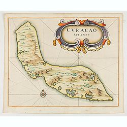
Curacao Eylandt.
One of the earliest separate maps of Curaçao. The map has nice topographical detail and features an ornate title cartouche. Published in de Laet's account of the history...
Place & Date: Amsterdam, 1644

Rooseveld rekende verkeerd ! De vangarmen van De Dollarpoliep worden afgesneden. . .
An remarkable Anti-American Dutch World War II propaganda poster by Lou Manche, showing an pink octopus, representing the United States, with its tentacles being cut from...
Place & Date: The Netherlands, 1942

Nieuwe Wassende Graadige Pas-kaart van de Kust van Guinea en Brasilia.
Rare two-sheet sea chart of the coasts of Brazil, West Africa and South Africa, published by Johannes Van Keulen (the younger), circa 1720.The chart shows the western coa...
Place & Date: Amsterdam, 1751

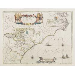
Virginiae Partis Australis, et Floridae Partis Orientalis.
Blaeu based this map on the Mercator-Hondius of 1606. A number of geographical improvements, however were incorporated, although two large fictions lakes accompanied by e...
Place & Date: Amsterdam, 1640

Guyana, Surinam, Amapa.
Very rare Ottoman printed map of Guyana, Suriname and Amapa. With Trinidad, an inset map of the mouth of the Rivers Essequibo, Courantyne, Suriname with Paramaribo.From C...
Place & Date: Üsküdar (Istanbul), 1803
Virginiae Partis Australis, et Floridae Partis Orientalis.
Blaeu based this map on the Mercator-Hondius of 1606. A number of geographical improvements, however were incorporated, although two large fictions lakes accompanied by e...
Place & Date: Amsterdam, 1640

Nuevo plano de la ciudad de Buenos Aires y parte del partido de avellaneda . . .
A rare detailed city plan of Buenos Aires prepared in 1912 by Ernesto Escalante. The plan depicts the city from the Partido de Avellaneda and the Villa Riachuelo to the R...
Place & Date: Buenos Aires, 1912

Virginie, Grande Region l'Amerique Septentrionale...
Pierre van der Aa used the old copper plate of Meurs and re-did the engraving, changed the large pictorial cartouche, a new scale of German and French leagues is provided...
Place & Date: Amsterdam, 1729

Stoel des Oorlogs in America Waar in Vertoont Werden Alle Desself Voornaamste Eylande . . .
Large impressive map of the West Indies with the Gulf of Mexico and Florida. The map shows prominently in the center Cuba, Haiti, the Bahamas and Florida, which is here m...
Place & Date: Amsterdam, c. 1720

Nader prolongatie van het Octroy voor de Westindische Compagnie voor den tyd van nog dertig jaaren. . .
A proclamation by the Dutch States General, dated 1761, extending the charter of the Dutch West India Company for another thirty years. Like the 1730 proclamation, it has...
Place & Date: Amsterdam, 1761

Manuscript plan of Havana harbour.
Manuscript chart with good nautical detail and soundings of Havana harbour.
Place & Date: Spain c.1820

La Florida/ Peruviae Auriferae regionis Typus/ Guastecan.
The Chaves map of Florida is a prime example of an explorer's map since it records the recent discoveries of Cabeza de Vaca, De Soto, and Moscoso. The map revealed little...
Place & Date: Antwerp, 1592

Cunard to Canada.
Poster by Charles Eddowes Turner for Cunard lines. The poster shows The NEW SYLVANIA, one of the four new 22,000 - ton Cunarders which are the largest ever built for serv...
Place & Date: England, ca. 1930

Map of the Great Salt Lake And Adjacent Country in the Territory Of Utah. Surveyed in 1849 and 1850, under the orders of Col. J.J. Abert ...
Map of the Great Salt Lake And Adjacent Country in the Territory Of Utah. Surveyed in 1849 and 1850, under the orders of Col. J.J. Abert .. by Capt. Howard Stansbury .. a...
Place & Date: Ackerman, New York, 1852

Nieuwe gemeten kaart van de colonie de Berbice met der zelver plantagiën en de namen der Bezitters. . .
Re-issue of his map from 1740, without the printed list of owners, with a large added contemp. hand-colored cartouche Relaas van de rebellie, ontstaan op de plantagien in...
Place & Date: Amsterdam, ca.1763

Tabula Magellanica.
A map with Willem Blaeu's signature, but published by his son Joan, of South America's extremity with the Strait of Magellan and Le Maire Strait.The coastlines are depict...
Place & Date: Amsterdam, 1658

Carte du Mexique et des Etats Unis d'Amérique...
A later edition of De l'Isle's foundation map of 1703, is widely regarded as one of the most influential maps in the history of American Cartography. This updated version...
Place & Date: Paris, 1783

Canibales Insulae.
Rare, early Dutch nautical chart of the Caribbean from Puerto Rico southward.
Place & Date: Amsterdam, 1670

Guaranty Trust Company of New York. Emprunt national 6%.n Souscrivez.
Very decorative propaganda poster with design by Mark All of Paris for "Guaranty Trust Company of New York", a JPMorgan Chase predecessor in order to promote th...
Place & Date: Paris, 1918

Il Cuscho citta principale della provincia del Peru.
A very desirable and scarce item of this decorative and early bid's-eye town-plan of the Inca city of Cuzco. Several figures shown inside the city walls and on the hillsi...
Place & Date: Lyons, 1564

Carte du Canada ou de la Nouvelle France.
A later edition of Guillaume De l'Isle's map. It still includes the fictitious discoveries of Baron de Lahoutan: the legendary River Longue etc. The northwest corner of H...
Place & Date: Amsterdam, 1730

Vorstellung Einiger Gegenden und Plaetze in Nord-America unter Franzoesisch und Englische Jurisdiction Gehoerig zu Finden bey den Homaennischen Erben in Nurnberg Ao. 1756.
Three town plans on one sheet of eastern Canada, including Quebec, Louisbourg and Halifax towns which the English and French fought to conquer on the American continent f...
Place & Date: Nuremberg, 1756
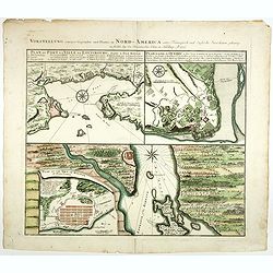
Vorstellung einiger Gegende und Plaetze in Nord America.
The title of the map in English: Picture of some surroundings and towns under French and English jurisdiction. With town plans of Louisburg on Isle Royal, Quebec and Hali...
Place & Date: Nurmberg 1756
![Partie de L'Amerique Septentrionale, qui comprend Le Cours De L'Ohio, La N[ouve]lle Angleterre, La N[ouve]lle York, Le New Jersey, La Pensylvanie, Le Maryland, La Virginie, La Caroline.](/uploads/cache/1129917-250x250.jpg)
Partie de L'Amerique Septentrionale, qui comprend Le Cours De L'Ohio, La N[ouve]lle Angleterre, La N[ouve]lle York, Le New Jersey, La Pensylvanie, Le Maryland, La Virginie, La Caroline.
Double page map of the East coast of America, showing the area from Maine to South Carolina. Inset map titled ""Supplement Pour La Caroline"" showing ...
Place & Date: Paris. 1755

Kiepert's Physikalische Wandkarten. VI. Nord-America.
Large folding school wall map of North and Central America printed in chromo-lithography. Published by Dieter Reimer and printed by Leopold Kraatz in Berlin. Three inset...
Place & Date: Berlin, Dieter Reimer, 1864

Sabena (USA - NYC).
Sabena Belgian World Airlines poster showing the skyline of New York in abstract style. Published by Rali Brisart in Belgium.La Sabena, acronym for Societé Anonyme Belg...
Place & Date: Brussels, ca. 1970

Carte Réduite De La Partie Septentrionale De L'' Isle De Terre Neuve..
A well engraved and highly detailed chart, corrected to 1767. Elaborate hand-colored cartouche, rhumb lines.Shows northern part of Newfoundland and southern coast of Labr...
Place & Date: Paris, 1767

20 small lithographed views of Washington DC and Georgetown.
20 small lithographed town-views of Washington DC and Georgetown, cut out from a larger sheet. Showing the East Front of the Capitol, Treasury, Smithsonian Institute, Pre...
Place & Date: Casimir Bohn, Washington, D.C.: 1849