Browse Listings in America

Rivage du port Saint-Nicolas.
Exquisite contemporary colored lithograph of Port Saint-Nicolmas Bay in most southern part of South America, with Dumont D'Urville's officers making landfall. Drawn by E....
Place & Date: Paris, 1846

Occidentalis Americae partis.
The most beautifully engraved early map of the Caribbean, including Florida and the Southeast. The map includes representations of Columbus' ships and various notes regar...
Place & Date: Frankfurt, 1594

Nieuwe Wassende Graadige Pas-kaart van de Kust van Guinea en Brasilia.
Rare two-sheet sea chart of the coasts of Brazil, West Africa and South Africa, published by Johannes Van Keulen (the younger), circa 1720.The chart shows the western coa...
Place & Date: Amsterdam, 1751

Americae Sive Novi Orbis, Nova Descriptio.
This is the second copperplate of Ortelius' map showing the western hemisphere, showing the prominent bulge in the South American coastline. An important map because of i...
Place & Date: Antwerp, 1579
![The Coast of New Found Land From Salmon Cove to Cape Bonavista. . . [together with] The Coast of New Found Land from Cape-Raze to Cape St-Francis.](/uploads/cache/40658-250x250.jpg)
The Coast of New Found Land From Salmon Cove to Cape Bonavista. . . [together with] The Coast of New Found Land from Cape-Raze to Cape St-Francis.
Two charts showing the coast of New Found Land from Salmon Cove to Cape Bonavista and from Cape-Raze to Cape St-Francis. With inset chart of Trinity HarborGrierson publis...
Place & Date: Dublin, 1767

The Harbour of Casco Bay and Islands Adjacent Bt Capt. Cyprian Southicke.
The earliest printed chart of Casco Bay, an inlet of the Gulf of Maine on the southern coast of Maine, New England. First issued in 1720 by Mount and Page, it remained in...
Place & Date: Dublin, 1767

Nova Virginiae Tabula.
A fine example of Blaeu's map of Virginia and the Chesapeake region is based on the first state of Smith's map, 1612, and is slightly larger and more expertly engraved.Th...
Place & Date: Amsterdam, 1640

(Totius Americae nova et exacta tabula ex) optimis tum geographorum tum aliorum scriptis collecta et ad hodiernam regnorum principatuum et maiorum partium distinctionem accomodata.
Eastern part of a two-sheet map of America, with attribution to Willem Blaeu. According to Philip Burden, the map was derived from Cornelius Danckert's 1647 map of the sa...
Place & Date: Rome, 1679
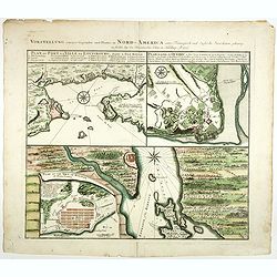
Vorstellung einiger Gegende und Plaetze in Nord America.
The title of the map in English: Picture of some surroundings and towns under French and English jurisdiction. With town plans of Louisburg on Isle Royal, Quebec and Hali...
Place & Date: Nurmberg 1756
![[Incas lay siege to Cusco.]](/uploads/cache/40353-250x250.jpg)
[Incas lay siege to Cusco.]
Atahualpa’s brother, Manco, organized a long and bloody siege to reoccupy the Inca capital, which eventually spread to open rebellion throughout the land. Pizarro, who ...
Place & Date: Frankfurt, M.Merian, 1633