Browse Listings in World Maps
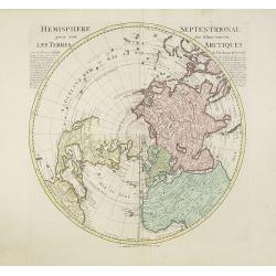
Hemisphere septentrional pour voir plus distinctement les terres arctiques. . .
Showing the Northern Hemisphere with North America, the Arctic, the Pacific, Asia and Europe after the cartographic source by the French map maker Guillaume De Isle. The ...
Place & Date: Amsterdam, c. 1740
Selling price: $1200
Sold in 2023
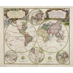
Planiglobii Terrestris - Mappe-Monde...
Word map in double hemisphere. In center two smaller hemispheres of the north and south pole are shown. Two interesting diagrams depict the earth as it would be seen from...
Place & Date: Nuremberg, 1746
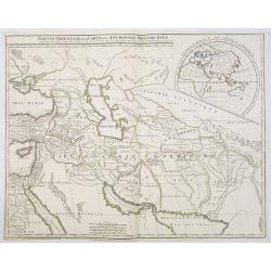
Partie Orientale de la Carte des Anciennes Monarchies. . .
This map depicts the eastern part of the Ancient World, Partie Occidentale de la Carte des Anciennes Monarchies including the Near East, Cyprus, Black Sea, Caspian Sea, I...
Place & Date: Paris, ca. 1800
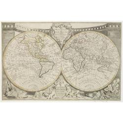
Mappemonde ou globe terestre dressée sur les Nouvelles Observations . . .
Scarce world map with all the major early explorers. Jean Baptiste Louis Clouet (born 1730) was a member of the Academie Royale des Sciences de Rouen and the author of Ge...
Place & Date: Paris, Mondhare, 1787

Orbis Terrae Compendiosa Descriptio.
Gerard Mercator's great world map of 1569 was condensed into double hemispherical form by his son Rumold. It first appeared in 1587 in Casaubon's edition of Strabo's Geog...
Place & Date: Amsterdam, 1595-1609
![[Printed on silk] Nieuw Wassende Graaden Paskaart Vertoonende alle de bekende Zeekusten en Landen op den geheelen Aard Boodem of Werelt door Gerard van Keulen. . .](/uploads/cache/31640-250x250.jpg)
[Printed on silk] Nieuw Wassende Graaden Paskaart Vertoonende alle de bekende Zeekusten en Landen op den geheelen Aard Boodem of Werelt door Gerard van Keulen. . .
A very scarce and beautiful chart on Mercator's projection printed on silk. With the name of Gerard van Keulen and the privilege. The map shows great interior detail, inc...
Place & Date: Amsterdam, 1728

Nansenbushu bankoku shoka no zu.
This map is a great example of Japanese world maps representing Buddhist cosmology with real-world cartography. It is the earliest one and - therefore - the prototype for...
Place & Date: Kyoto, (Hoei 7 = Year of the Tiger) 1710

Nouvelle et exacte description du globe terrestre reveue corrigée et augmente´e suivant les derniéres relations des Anglais et Hollandois. Par Guillaume Blaeu 1645.
Extremely rare and decorative "carte a figures" world map published by Anthoine de Fer. The double hemisphere world map is surrounded by constellations of the A...
Place & Date: Paris, 1645
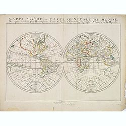
Mappe-Monde, ou Carte Generale du Monde: Dessignée en deux plans Hemispheres Par le Sr. Sanson d'Abbeville, Geographe ordinaire de sa Majesté.
Sanson's first world maps, dated 1651 and 1652, were issued separately and then in collections of mapsThe map is one of the first to distinguish the Great Lakes, all five...
Place & Date: Paris, 1651

Le globe terrestre representé en deux plans-hemispheres, Dressé sur la Projection de Mr. De la Hyre...
“This splendid GlobeTerrestre originally published by J.B. Nolin is one of the finest large-scale world maps to be produced and is a fitting bridge between the geograph...
Place & Date: Paris, c. 1780