Browse Listings

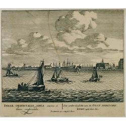
Vue générale d'Amsterdam.
A so-called optical prints, showing Amsterdam seen from the IJ. A lively scene with extensive shipping. To the left the headquarters of the V.O.C., nowadays the Maritime ...
Place & Date: Paris, ca. 1750

Vue du village de Maarsen en Hollande.
Showing the river Vecht at the town of Maarsen. Published by Jacques Chereau, who was a well-known publisher of optical prints, established in rue St. Jacques in Paris. I...
Place & Date: Paris, ca. 1750

Perspective du Voorhout, promenade publique de La Haye.
Showing the Voorhout in The Hague. Likely published by Mondhard, who was a well-known publisher of optical prints, established in rue St.Martin in Paris. In the eighteent...
Place & Date: Paris, ca. 1750

Océanie.
A very decorative 19th century map of the Pacific Ocean, with hand colored lines indicating the extent of Polynesia, Mirconesia, Melanesia, and Malaysia (or Southeast Asi...
Place & Date: Paris, 1850

A newe mape of Tartary.
Early edition of one of the most decorative "carte à figures"- map of Tartary, known for its figured borders with costume figures, while above are vignettes of...
Place & Date: London, 1627

DELFT. Delphium urbs Hollandiae cultissima. . .
A bird's-eye view of the town of Delft. From the first Dutch translation of Guicciardini's description of the Netherlands. In this town-plan, three buildings, still domin...
Place & Date: Amsterdam, 1612

Nuova Pianta Iconografica.. Venezia.
Precise bird's-eye town-plan of Venice, clearly depicting the city's architectural landmark, being a reduction of Ughi's 8-sheet map of 1725. There is a grid engraved ove...
Place & Date: Venice, 1818
![Bunken Edo oezu. [Tokyo]](/uploads/cache/12826-250x250.jpg)
Bunken Edo oezu. [Tokyo]
Based on map by Ochikochi Doin. Oriented with north to the right. An extraordinary wood block-printed town-plan now-a-day Tokyo, and a fine example of Edo cartography. Th...
Place & Date: Edo, ca. 1803

Irlandiae Regnum.
A very nice map from Ireland.Mercator was born in Rupelmonde in Flanders and studied in Louvain under Gemma Frisius, Dutch writer, astronomer and mathematician. The excel...
Place & Date: Amsterdam, 1630
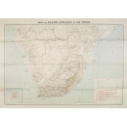
Carte des Missions Catholiques du Sud Africain.
Map of the Catholic Missions in South Africa. Inset map of L'Ile St. Hélène.Published as supplement of the Les Missions Catholiques. To the lower right an inset key to ...
Place & Date: Paris, Monrocq, 1902

Madrid.
Extremely rare town-view of Madrid. Engraved by Francesco Ambrosi.With a second title in lower part "Madrid Ciudad Capital Del Reyno D'Espana y real corte de los rey...
Place & Date: Bassano del Grappa, c.1780

La Tartaria Chinese.
With decorative title cartouche. Covering north eastern part of China, Korea and Hokkaido (here called Jeso-Gasima, Tartary including the Gobi Desert; also Peking and the...
Place & Date: Venice, 1784

Cajanie, ou Bothnie Orientale Tirée de celles d'Andr Burae et de Isaac Massa. . .
Map of the Northern part of Gulf of Bothnia, today's border area between Sweden and Finland. The map derive from the work of the Swedish cartographer Andreas Bureus and I...
Place & Date: Paris, P.Mariette, 1666

EUROP, and the cheife Cities contayned therin described. . .
A good impression from an early edition of this famous and decorative "carte à figures"- map from the first world atlas produced by an Englishman - John Speed'...
Place & Date: London, 1627 - 1676

Jerusalem.
Engraved by Bastiaan Stoopendaal from Juan Bautista Villapando's imaginary town-plan of Jerusalem. This bird's-eye view is surrounded by 12 scenes, views and portraits of...
Place & Date: Amsterdam, 1682
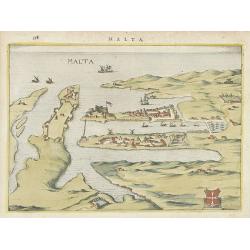
Malta.
Attractive birds-eye town-view of Valetta on Malta. With coat of arms lower right. With page number 398 in top. Latin text on verso.
Place & Date: The Netherlands ? 1650

Carte Marine De La Mer Caspiene levée suivant les ordres de S.M.Cz. En 1719, 1720 et 1721.
Detailed of the Caspian Sea, prepared by Karl van Verden in 1722. Van Verden was a Russian sailor and the Czar's Special Commander, who produced the first accurate map of...
Place & Date: Paris, ca. 1725

Neapolis.
A rare panoramic of Naples with over the whole length of the lower part 3 columns of poems in Latin, Dutch and French.Published by Dancker Danckerts (1634-1666).
Place & Date: Amsterdam, 1660
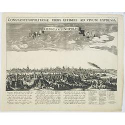
Constantinopolitanae urbis effigies ad vivum expressa.
A rare panoramic town-view of Istanbul with over the whole length of the lower part 3 columns of poems in Latin, Dutch and French and a numbered key 1-29 to the principal...
Place & Date: Amsterdam, 1660
![Praga. [Prague]](/uploads/cache/28442-250x250.jpg)
Praga. [Prague]
A rare panoramic of Prague with over the whole length of the lower part 3 columns of poems in Latin, Dutch and French and a numbered key 1-34 to the principal buildings ...
Place & Date: Amsterdam, 1660

Plan de la ville, cite universite et fauxbourgs de Paris comme il est jourddhuy. . .
Detailed town-plan of Paris.Top left and bottom right and left cartouches decorated with views of the top left, Notre Dame, Palace of Orleans, Sorbonne and Val de Grâce,...
Place & Date: Paris, 1694

NEWTON'S New and Improved TERRESTRIAL GLOBE Accurately delineated from the observations of the most esteemed NAVIGATORS AND TRAVELLERS to the Present Time. . .
A very impressive Victorian 20-inch Library globe showing the "Gulf of Corea". On an exceptionally carved mahogany tripod stand with scrolling acanthus legs ter...
Place & Date: London, January 1, 1867
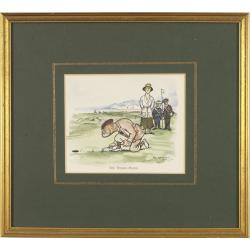
Mr. Punch on the Links.
Golfing cartoon taken from the famed English humor magazine Mr. Punch on the Links. Size of the frame : 23x25cm.THE WOMAN-HATER.After Frank Reynolds (1876 - 1953 ). He wa...
Place & Date: London, Methuen: 1929
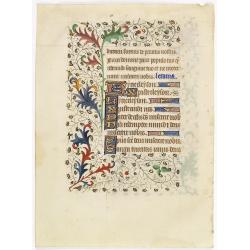
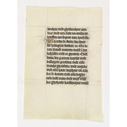
A manuscript leaf from a Book of Hours.
RECTO: Four 1-line initials in liquid gold on colored grounds. colorful panel border of acanthus leaves and flowers, with black penwork.VERSO: One 2-line initial and seve...
Place & Date: Western France, ca. 1445

Les Villes forts et châteaux de Malte capitale de l'isle de ce nom. Dessignée sur le lieu par un Ingr du roy.
A very decorative and extremely rare town-view of Valetta, including a numbered legend in lower part. Published by Jacques Chereau, (1688 - 1776). Engraved by Aveline and...
Place & Date: Paris, ca.1750
![[ LANDSKROON ]. Oranda Fune no zu [= Depiction of a Dutch Ship].](/uploads/cache/28003-250x250.jpg)
[ LANDSKROON ]. Oranda Fune no zu [= Depiction of a Dutch Ship].
A very large and extremely detailed Japanese drawing on rice paper of a Dutch ship at the artificial island Deshima, the VOC's outpost in Nagasaki harbour. In the drawing...
Place & Date: Japan, Kansei 4, 2nd month, 9th day, 30 March? 1792
Een ander gesicht van de Oost Indische Werf: uyt het Ye.
Decorative engraving giving good detail of the entrance of the IJ with in the background the ship building wharf of the V.O.C. and its ware house, presently the Maritime ...
Place & Date: Amsterdam, 1670
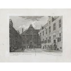
Gezicht van het Oost-Indisch-Huys, op de binnen plaats te zien, tot Amsterdam.
Taken from the "Atlas of Amsterdam". Showing the inner square of the East Indian House of the V.O.C. in Amsterdam.A place for meeting, trading and storage of sp...
Place & Date: Amsterdam, 1780
-250x250.jpg)
Hern Johann Baptisten Taveniers..Vierzig Jaehrige Reize..
This German edition includes Tavernier's map of Japan in a reduced form (210x315mm) and contains legends about the country's nature, e.g., where gold is mined and plottin...
Place & Date: Nuremberg, 1681

Vue de Boston vers le Cale du Port.
A view of the port of Boston, the center of New England shipping in the colonial period. The closing of the port after the Boston Tea Party led to the calling of the Firs...
Place & Date: Augsburg 1762

Account of a voyage of discovery to the west coast of Corea.
BRITAIN'S FIRST ACCURATE ACCOUNT OF KOREA & OKINAWANS. With an appendix containing charts and various hydrographical and scientific notices by captain Basil Hall and ...
Place & Date: London, 1818
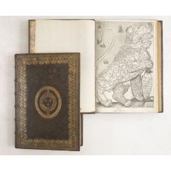
De Bello Belgico, Decas PrimaDeces II.
Each volume contains an engraved title with a representation of the Netherlands and Belgium in the shape of a lion, with one paw resting on a shield bearing the title, a ...
Place & Date: Rome, Franciscus Corbelletus, 1632-1647

Souvenirs des Pyrénées. Vues prises aux environs des eaux thermales de Bagnères-de-Bigorre, Bagnères-de-Luchon, Cauteretz, Saint-Sauveur, Barèges, Les-eaux-Bonnes, Les-Eaux-Chaudes & Pau.
The thermal baths Bagnères de Bigorre, Bagnères de Luchon, Cauteretz, Saint-Sauveur, Barèges, Les Eaux-Bonnes and Pau in the Pyrenees. Beautiful collection of 24 litho...
Place & Date: Pau, A.Basset, ca. 1860

Nieuwe gemeten kaart van de colonie de Berbice met der zelver plantagiën en de namen der Bezitters. . .
Re-issue of his map from 1740, without the printed list of owners, with a large added contemp. hand-colored cartouche Relaas van de rebellie, ontstaan op de plantagien in...
Place & Date: Amsterdam, ca.1763

Angliae, Scotiae, et Hiberniae, sive Britannicar : Insularum descriptio.
A rare and ornate map with inset portraits of James First, Henry Prince of Wales Princess Anne of Denmark.Janssonius acquired the copperplate of van den Keere's 1604 Brit...
Place & Date: Amsterdam, 1621
Manuscript leaf on vellum from a Dutch Book of Hours.
A leaf from a medieval manuscript Book of Hours, written in Utrecht.Fourteen lines of monastic Textura script with 4 two-line initial "I" in liquid gold on a bl...
Place & Date: Utrecht, ca.1450 - 1460
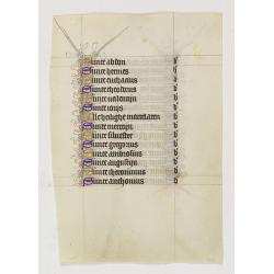
Manuscript leaf on vellum from a Dutch Book of Hours.
A leaf from a medieval manuscript Book of Hours, written in Utrecht.Fourteen lines of monastic Textura script with fourteen 1-line initials in blue or gold with extensive...
Place & Date: Utrecht, ca.1450 - 1460

Het stadhuis, van vooren.
The former Amsterdam Town Hall, now the Royal Palace. Copper engraving by Frans de Bakker after Reinier Vinkeles (1741-1816).From the well-known description of Amsterdam ...
Place & Date: Amsterdam, 1765
![Summa philosophiae quadripartita, de rebus dialecticis, moralibus et metaphysicis . . [ With unrecorded world map ]](/uploads/cache/28639-250x250.jpg)
Summa philosophiae quadripartita, de rebus dialecticis, moralibus et metaphysicis . . [ With unrecorded world map ]
On page 107 a finely copper engraved world map (88x84mm.) Paradigma Terrae Plagas 4.ac 12. Ventorum situm indicans., centered on Europe and Africa, with parts of America,...
Place & Date: Leiden, Peter Rigaud, 1626

Carte d'Afrique Dressée pour l'instruction par Guillaume DeLisle. . .
The map is a rare re-issue of the Delisle map of 1722. In his first map of the continent in 1700, Delisle re-measured the Mediterranean, being the first to establish its ...
Place & Date: Paris, J.Dezauche, 1819