Browse Listings in Europe

Tabula Episcopatuum Leodiensis et Coloniensis. . .
Rare issue of Cornelis Danckert's attractive map of Limburg, shows the area of Cologne, Mainz, Trier, Jülich, Mons, Antwerp and Liege in Belgium.Decorative title cartouc...
Place & Date: Amsterdam, 1700

Province de Pologne contenant 22 Col. une M.on Prof 5 Pen. 2 Nov. 6 Rés. 30 Maisons 1050 Jésuites.
Rare map of Poland from "Atlas Universel indiquant les établissemens des Jésuites: avec la manière dont ils divisent la terre, suivi desévénemens remarquables d...
Place & Date: Paris, Ambroise Dupont , 1826

Provincie Noord-Braband.
Decorative and uncommon costume plate lithographed by Desguerrois & Co. and published by Frans Buffa & Zonen in Amsterdam. 12 illustrations of Brabant costumes: 1...
Place & Date: Amsterdam, 1857

Tabula Bergarum ad Zomam Stenbergae et novorum ibi operum.
The map gives an outline of the Scheldt from Bergen op Zoom to Antwerp, with all the ramparts built between 1622 and 1627.
Place & Date: Amsterdam, 1647

s'Lants Zee-Magazyn en Scheeps Timmer-werf.
Decorative view of the back yard of the formerly the V.O.C. warehouse and arsenal for the Admiralty of Amsterdam, now-a-days the Scheepvaartmuseum (Maritime Museum).The p...
Place & Date: Amsterdam, 1694

Vuë du dedans de l'Eglise de St. MARTIN à Londre.
So-called optical print illustrating a perspective view of the central aisle of St. Martin's church, in London.In the eighteenth and nineteenth centuries there were many ...
Place & Date: Paris, 1760
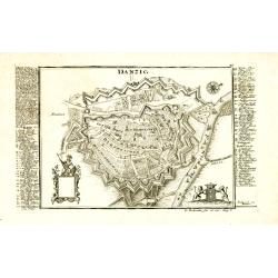
Danzig.
Detailed and rare plan of Danzig with extensive key in German.
Place & Date: Augsburg, 1730

Kaart van Zeeland.
Fine map of the province of Zeeland, with the fortified cities are highlighted in red. Isaac Tirion was born in Utrecht ca. 1705. He came to Amsterdam ca. 1725. Tirion pu...
Place & Date: Amsterdam, 1747

Map of Russia and Poland.
Charming, folding map of Russia, Poland and Baltic States, still in its original publisher's blind stamped linen wrapper with yellow label. With yellow advertisements at ...
Place & Date: London, ca. 1894

Provincia ecclesiastica di Malines nel Belgio (Tav LXII)
This large-format map of Belgium with its different dioceses. The map is finely engraved and beautifully colored and was prepared by Girolamo Petri, a lawyer who served a...
Place & Date: Rome, 1858