Browse Listings in America
![[Soil map] Virginia-Maryland-West Virginia, Leesburg sheet.](/uploads/cache/23257-250x250.jpg)
[Soil map] Virginia-Maryland-West Virginia, Leesburg sheet.
Early color lithographed soil map by Julius Bien & Co. in New York for Department of Agriculture. Legends at side give detail on soil type, etc. They also include int...
Place & Date: New York, 1903
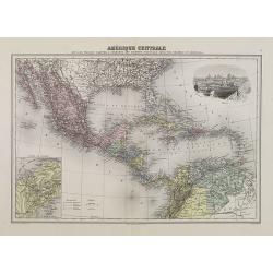
Amérique Centrale.
Decorative map of Central America from Géographie Universelle, Atlas Migeon. With an inset map of the Isthmus of Panama lower left corner and a panoramic view of Mexico ...
Place & Date: Paris, 1874
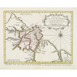
Carte de L'Isle de Caiene et de ses environs.
Uncommon edition of this accurate map of Cayenne. In lower right engraved "31."From Atlas Portatif pour servir a l'intelligence de l'Histoire Philosophique et P...
Place & Date: Amsterdam, 1773
![[ Cofre de Perote ].](/uploads/cache/27569-250x250.jpg)
[ Cofre de Perote ].
Aquatint depicting the Cofre de Perote engraved by Fumagalli. Plate N°59.Cofre de Perote, mean something like 'Mountain of the Lord of Four Places'. This extinct volcano...
Place & Date: Milan, 1827
![[The dogs of Vasco Nunez de Balboa attacking native Indians]](/uploads/cache/40484-250x250.jpg)
[The dogs of Vasco Nunez de Balboa attacking native Indians]
A brutal scene in which the dogs of the Spanish explorer Vasco Nunez de Balboa, ferociously attack native Indians, while the Spanish look on.In 1631 Johann Ludwig Gottfri...
Place & Date: Frankfurt, M.Merian, 1633
![[ Bread making ].](/uploads/cache/27591-250x250.jpg)
[ Bread making ].
Aquatint depicting a family making bread engraved by Gallina. Plate N°82.From Giulio Ferrario's work Le Costume Ancien et Moderne ou Histoire du gouvernement, de la mili...
Place & Date: Milan, 1827
![[ Local Mexican Indian game, the Voladores de Papantla ].](/uploads/cache/27587-250x250.jpg)
[ Local Mexican Indian game, the Voladores de Papantla ].
Aquatint depicting local game engraved by Fumagalli. Plate N°77.The Aztecs also had spectacular dances such as the Voladores de Papantla ,the Sun Dance, in which the dan...
Place & Date: Milan, 1827

Carte Geographique, Statistique et Historique de l'Amerique Meridionale.
A nice detailed map of South America from Buchon's Atlas Gégraphique Statistique, historique et chronologique des deux Ameriques et des isles adjacentes traduit de l'atl...
Place & Date: Paris, 1825

Coast to Coast.
A game board that features a map of the U.S. with a built-in spinner. Players travel a circular track around the map visiting landmarks as they go. A fun way to learn geo...
Place & Date: New York, ca. 1950
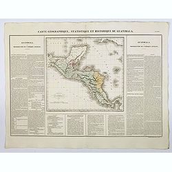
Carte Geographique, Statistique et Historique de Guatimala.
A nice detailed map of Guatemala from Buchon's Atlas Gégraphique Statistique, historique et chronologique des deux Ameriques et des isles adjacentes traduit de l'atlas e...
Place & Date: Paris, 1825