Browse Listings in Africa > North Africa

Insulae de Cabo Verde olim Hesperides sive .. Zoute Eylanden.
Original copper engraving, hand colored in outline, when published. Double page chart covering detailed the Cap Verde Islands in the Atlantic Ocean (Isla de San Antonia, ...
Place & Date: Amsterdam, 1655

Manoeuvres executées du 7 au 13 mai sous le Commandement du général Koeltz,par le XIXe Corps d'Armée. . .
Poster by Gaston Ry [aka René Rostagny] (1902-1978) showing the allied manouvers in Tunesia. On May 4, 1943, the nineteenth CA offensive drew most of the German tanks to...
Place & Date: Alger, Bacconnier, 1943

Nieuwe Pascaert van al de Carnarisse Eylanden. . .
So-called "Blue-back" sea- charts of the Canary Islands.Latitude scale, compass rose and system of rhumb lines, soundings, anchorage's, etc. A wealth of cities ...
Place & Date: Amsterdam, 1700
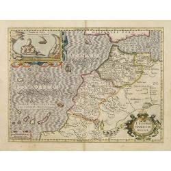
Fessae et Marocchi Regna.
One of the new maps added by Hondius, when he took over publication of the Atlas, a finely engraved and decorative map of north-west Africa, with the Canaries. With an in...
Place & Date: Amsterdam, 1630

Tabula Prima Africa.
The map apart from depicting Morocco also shows southern Spain and the Balearic Islands. In north Africa the map extends eastwards toward modern day Algeria and to the we...
Place & Date: Strasbourg, 1513

L'Art arabe d'après les monuments du Kaire depuis le VIIe siècle jusqu'à la fin du XVIIIe.
Prisse d’Avennes was one of the foremost scholars of Arabic art and architecture of the 19th century; this work represents the summation of his studies. From the aspect...
Place & Date: Paris, Morel, 1877