Browse Listings in Europe > Netherlands

Les Provinces des Pays Bas.
RARE. From his first edition of his only folio atlas, the map is relied upon the map of his uncle, Nicolas Sanson. Engraved by I.Somer.A nice map of Netherlands.
Place & Date: Paris 1687
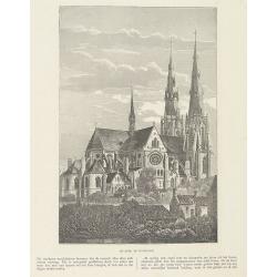
Sint Catharinakerk te Eindhoven.
Uncommon woodblock engraving of St.Catharina church of Eindhoven, built by the well-known architect P.Cuijpers. Published in Katholieke Illustratie.The "katholieke i...
Place & Date: 'sHertogenbosch, Henri Bogaerts, 1875

Les Provinces confederées du Pais-Bas
The first wall map of the Seven Provinces of 1651, re-issued as 'Stoel des Oorlogs' by Covens & Mortier. The first issue of the present wall-map is known to be includ...
Place & Date: Amsterdam, c. 1740

Quarta pars Brabantiae cujus caput Sylvaducis.
A good and dark impression in strong original colors.The third state. The coat of arms of Brabant and 's-Hertogenbosch appears on the map. The municipal arms in the colum...
Place & Date: Amsterdam, 1645

Quarta pars Brabantiae cujus caput Sylvaducis.
A good and dark impression in strong original colors.The third state. The coat of arms of Brabant and 's-Hertogenbosch appears on the map. The municipal arms in the colum...
Place & Date: Amsterdam, 1645

Over deese grietenije.. Eerste van Wester Goo..
Very decorative map centered on Menaam, Marsum and Boxum from the Uitbeelding der Heerlijkheit Friesland prepared by Schotanus. With decorative title cartouche lower righ...
Place & Date: Leeuwarden, F.Halma, 1718

Perspective du Voorhout, promenade publique de La Haye.
Showing the Voorhout in The Hague. Likely published by Mondhard, who was a well-known publisher of optical prints, established in rue St.Martin in Paris. In the eighteent...
Place & Date: Paris, ca. 1750

III. Carte de la Hollande.. Over-Yssel.
Attractive small map centered on the delta of the River Ijssel, where it discharges into the Zuiderzee.From Atlas Portatif Universel, by Robert de Vaugondy. Unrecorded st...
Place & Date: Paris, later than 1748

VI. Partie du Duche de Gueldre où se trouve la Veluwe.
Attractive small map covering the northwestern part of Gelderland. In the center "'t Loo". From Atlas Portatif Universel, by Robert de Vaugondy.Unrecorded state...
Place & Date: Paris, later than 1748

Henna ardera deel. De vijfde Grietenije van de Wester goo. . .
Very detailed map of "Henna ardera deel. De vijfde Grietenije van de Wester goo" in Friesland prepared by Bernardus Schotanus Steringa. With decorative title ca...
Place & Date: Leeuwarden, 1718

Donger deel.. derde grietenije van Ooster Goo. . .
Very decorative map of the area north of Dokkum from the Uitbeelding der Heerlijkheit Friesland prepared by Schotanus. With decorative title cartouche lower right mention...
Place & Date: Leeuwarden, F.Halma, 1718

Nieuwe kaart van het Koningrijk der Nederlanden. . .
Uncommon map of the Netherlands prepared by J.S. Smulders and P. H. Witkamp and lithographed by Z.M. den Koning in the Hague. Dated.Showing The Kingdom of the Netherlands...
Place & Date: The Hague, 1874

Dongerdeel.. De vierde grietenij van Ooster Goo.
Very decorative map centred on Dokkum, Metzerwier and Pasens from the Uitbeelding der Heerlijkheit Friesland prepared by Schotanus. With decorative title cartouche lower ...
Place & Date: Leeuwarden, F.Halma, 1718

Kollumer land En het Nieuw Kruys land de vijfde gritenije van Oostergoo . . .
Very detailed map of "Kollumer land En het Nieuw Kruys land de vijfde gritenije van Oostergoo" in Friesland prepared by Bernardus Schotanus Steringa. Centered o...
Place & Date: Leeuwarden, F. Halma, 1718

Comitatus Zutphania.
A very detailed map of this area, including Arnhem, Nijmegen, Zutphen, Groenlo, etc. First imprint, from a Latin edition of the scarce Atlas Appendix.
Place & Date: Amsterdam, 1637

Ducatus Limburg.
A very rare issue of this map of Limburg. Cornelis Danckerts II. copied the folio map of H.Hondius.The publisher's address was placed in the lower right-hand corner. The ...
Place & Date: Amsterdam, 1636

Tabula Ducatus Brabantiae.
Detailed map orientated west to the top.
Place & Date: Amsterdam, 1680

s'Lants Zee-Magazyn en Scheeps Timmer-werf.
Decorative view of the back yard of the formerly the V.O.C. warehouse and arsenal for the Admiralty of Amsterdam, now-a-days the Scheepvaartmuseum (Maritime Museum).The p...
Place & Date: Amsterdam, 1694

Gezicht van het Admiraliteits-Magazyn en Scheeps Timmerwerf.
Formerly the V.O.C. warehouse and arsenal for the Admiralty of Amsterdam, now-a-days the Scheepvaartmuseum (Maritime Museum). Taken from the "Atlas of Amsterdam"...
Place & Date: Amsterdam, 1780

A Perspective View of the Admiralty Office, Dock-Yard, Storehouses &c. at Amsterdam.
Decorative engraving giving good detail of the intense activity in the Amsterdam dockyards.Engraved for BANKES's New System of Geography
Place & Date: Amsterdam, 1780

Vue du Magazin de la Compagnie des Indes Orientales. . .
So-called optical print of the formerly the V.O.C. warehouse and arsenal for the Admiralty of Amsterdam, now-a-days the Scheepvaartmuseum (Maritime Museum).In the eightee...
Place & Date: France, 1780

Belgica Foederata. . .
Decorated with a cartouche showing the coats of arms of Zeeland, Holland, Utrecht, Friesland, Groningen and Overijssel. T.C. Lotter married M. Seutter's daughter in 1740 ...
Place & Date: Augsburg, ca.1760

Profil de la renomée ville et port d'Emstredam cappitalle des estats de Hollande.
Extremely rare panoramic town-view of Amsterdam seen from the river IJ.Exceptional bright, sharp example.The print is skillful copy of the print of Matthieu Merian, now w...
Place & Date: Paris, 1647