Browse Listings
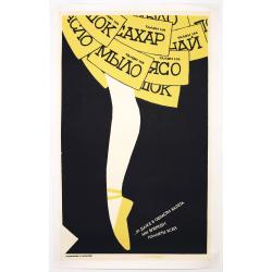
Russian Perestroika Ballet Poster.
Wonderful and delicate Russian Perestroika poster depicting a ballerina. On the frills of her skirt, there are several messages written down, which mean « a coupon for s...
Date: Russia, 1990
![Grote Atlas van de Verenigde Oost-Indische [Complete set of 7 volumes] Compagnie/Comprehensive Atlas of the Dutch United East India Company](/uploads/cache/49206-250x250.jpg)
Grote Atlas van de Verenigde Oost-Indische [Complete set of 7 volumes] Compagnie/Comprehensive Atlas of the Dutch United East India Company
This seven volume atlas was published in a limited edition. It covers all territories and possessions under the Charter of the Dutch East India Company (VOC) from 1602-17...
Date: Voorburg, Asia Maior/Atlas Maior, 2006-2010

Carte géologique détaillée. Beyrouth.
Geological or soil map showing part of Lebanon with Beyrouth, including in top a colored legend with signs of the different geological ages. Provenance : Fondation P. Fal...
Date: Liban, Service geographique des F.F.L., 1945.

Carte géologique détaillée. Jezzîne.
Geological or soil map showing part of Lebanon with Jezzîne, including a legend with signs of the different geological ages and giving many information of greatest inter...
Date: Liban, Service geographique des F.F.L., 1945.

Carte géologique détaillée. Râchaïya Nord.
Geological or soil map showing part of Lebanon with Râchaïya , including a legend with signs of the different geological ages and giving many informations of greatest i...
Date: Liban, Service geographique des F.F.L., 1945.

Carte géologique détaillée. Zahle.
Geological map showing part of Lebanon with Zahle. , including a legend with signs of the different geological ages. Provenance : Fondation P. Fallot
Date: Liban, Service geographique des F.F.L., 1945.

Carte geologique detaillee. Jbail.
Geological or soil map showing part of Lebanon with Jbail antique Byblos Ancien Port phenicien / scale 1 : 50 000., including a legend with signs of the different geologi...
Date: Liban, Service geographique des F.F.L., 1945.
![[Set of two maps of the Pacific Ocean with transportation lines, with Ottoman script]](/uploads/cache/44327-250x250.jpg)
[Set of two maps of the Pacific Ocean with transportation lines, with Ottoman script]
Two post card size maps showing the Pacific Ocean with transportation lines. The maps are in Ottoman script prepared by Mehmet EŞREF in a small atlas : عمومولاي...
Date: Istanbul, Şirket-i Mürettibiye ve Karacoğlu Matbaas&#

