Browse Listings in Map Types > Curiosities general
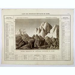
Carte des Principales Montagnes du Globe.
A nice detailed depiction of the principal mountains of the world from Buchon's Atlas Gégraphique Statistique, historique et chronologique des deux Ameriques et des isle...
Place & Date: Paris, 1825

Tabula Anemographica seu Pyxis Nautica.
Impressive compass rose with a fleur de lis at the center and 32 wind directions flowing from it identified in six languages, Greek, Latin, French, Dutch, Italian, and Sp...
Place & Date: Amsterdam, 1650

Mappa Humoristico da Europa.
A really unusual and lovely map, published in Portugal at the outbreak of The Great War in 1914. This outbreak of war in Europe was the result of a complex sequence of ev...
Place & Date: Lisbon, 1914

La Piovra Russa. Carta Serio-Comica Pel 1878.
Very rare political caricature map by Grossi of the nations of Europe, published in Bologna in the supplement of the newspaper "Le Perroquet / Al papagallo, N° 15, ...
Place & Date: Bologne, 14 avril 1878

Un Reclutatore in India. Papagallo No. 42. Anno VI.
British in India. Design by Augusto Grossi. Taken from the Italian satirical newspaper Il Papagallo, a satirical magazine founded in January 1873 by Augusto Grossi (1835-...
Place & Date: Bologne, 1878

La pericolante ostinata. Papagallo No. 20 Anno II.
Design by Augusto Grossi. Taken from the Italian satirical newspaper Il Papagallo, a satirical magazine founded in January 1873 by Augusto Grossi (1835-1919), which speci...
Place & Date: Bologne, 1874

L'Europe en Sept 1939. Ille terrarum mihi angulus ridet.
A rare oversized serio-comic map of Europe at the start of the Second World War depicting stereotypes of 31 countries, as listed in the key lower right, including Brit...
Place & Date: Bruges, Leon Burghgraeve, 1939

Carriers of the New Black Plague.
A powerful satirical commentary on totalitarian control of speech from the first issue of Ken Magazine. "Caught here in all their peculiar beauty by the soul searchi...
Place & Date: Chicago, 1938
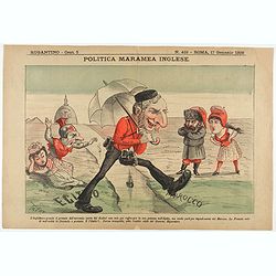
Politica Maramea Inglese - Rugantino - n°419 - Roma 17 Gennaio 1892.
Satirical print relating to the British Conquest of Egypt (1882), also known as Anglo–Egyptian War, between Egyptian and Sudanese forces under Ahmed ‘Urabi and the Un...
Place & Date: Rome, January 17, 1892

Atlas Geographique. (Puzzle).
Three map puzzles, each measuring 25 x 33 cm., housed in the original color printed card case. Geographical jigsaw puzzle set comprising three maps (world, Europe and Fra...
Place & Date: Paris, ca. 1910