Subscribe to be notified if similar examples become available.
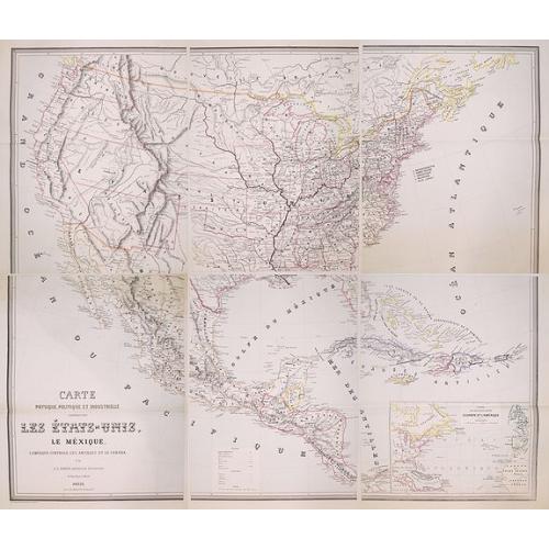

Carte Physique, Politique et Industrielle Comprenant: Les Etats-Unis, Le Mexique, L'Amerique Centrale, Les Antilles et Le Canada. Par J.L. Sanis, Ingenieur Geographe. |
||||||||||||||||||||
|
||||||||||||||||||||
|
|
||||||||||||||||||||
|
|
Virtual Collection - Save and collect this or any of your favorite items in one place.
If you want to save the items permanently, please sign in or create account first. |
|||||||||||||||||||
Description
Rare 6 sheet map of the United States by J.L. Sanis, published by Erhard in 1862. Engraved by Erhard. For the dating of the map, we are relying upon a catalog entry in the Bibliotheque Nationale de France and the dating of the 2 recorded examples (British Library and BNF).
"The map shows a fantastic depiction of the Western United States, pre-dating the creation of Arizona Territory, Nevada, and Colorado Territories, and still showing massive Nebraska Territory, including all of the area which would become Wyoming Territory and Montana Territory. Several interesting early Territorial capital cities are shown, including Fillmore City, Utah. Several important early roads in the west are also located.
Jean Leon Sanis seems to have flourished from 1854 to 1861 when he and Delalleau de Bailliencourt published the Geographie Historique de la France - Atlas Special. The atlas was published for Napoleon III and was critical of the preceding governments. Most notably, the text opposite the map of France under Louis XVIII, Charles X, Louis-Philippe, and the Second Republic (1815-1848) claimed that these regimes had not tried to modify the terms of the Congress of Vienna, terms that it alleged humiliated France. In addition, the atlas offered evidence of France's heroic and successful past.
It is quite possible that the map was prepared several years earlier, as the sole source for dating the map appears to be a catalog entry in an old journal, which may not necessarily reflect the first date of publication." (source B.L.Rudermann)
OCLC locates 2 examples of the map (British Library and Bibliotheque Nationale de France). No copies in American institutions.
6 sheets, unfolded and untrimmed and generally in fine condition—two very faint spots.
FAQ - Guarantee - Shipping
Buying in the BuyNow Gallery
This item is available for immediate purchase when a "Add to Cart" or "Inquire Now" button is shown.
Items are sold in the EU margin scheme
Payments are accepted in Euros or US Dollars.
Authenticity Guarantee
 We provide professional descriptions, condition report (based on 45 years experience in the map business)
Paulus Swaen warrants the authenticity of our items and a certificate of authenticity is provided for each acquired lot.
Condition and Coloring
We indicate the condition of each item and use our unnique HiBCoR grading system in which four key items determine a map's value: Historical Importance, Beauty, Condition/Coloring and Rarity.
Color Key
We offer many maps in their original black and white condition. We do not systematically color-up maps to make them more sellable to the general public or buyer.
Copper engraved or wood block maps are always hand colored. Maps were initially colored for aesthetic reasons and to improve readability. Nowadays, it is becoming a challenge to find maps in their original colors and are therefor more valuable.
We use the following color keys in our catalog:
Original colors; mean that the colors have been applied around the time the map was issued.
Original o/l colors; means the map has only the borders colored at the time of publication.
Colored; If the colors are applied recently or at the end of the 20th century.
Read more about coloring of maps [+]
Shipping fee
A flat shipping fee of $ 30 is added to each shipment by DHL within Europe and North America. This covers : International Priority shipping, Packing and Insurance (up to the invoice amount).
Shipments to Asia are $ 40 and rest of the world $50
We charge only one shipping fee when you have been successful on multiple items or when you want to combine gallery and auction purchases.
Read more about invoicing and shipping
FAQ
Please have a look for more information about buying in the BuyNow gallery
Many answers are likely to find in the general help section.
Virtual Collection
![]()
With Virtual Collection you can collect all your favorite items in one place. It is free, and anyone can create his or her Virtual map collection.
Unless you are logged in, the item is only saved for this session. You have to be registed and logged-in if you want to save this item permanently to your Virtual Collection.
Read More[+]
Register here, it is free and you do not need a credit card.
Add this item to
Virtual Collection
or click the following link to see my Virtual Collection.
| Digital Image Download | |
|
Paulus Swaen maintains an archive of most of our high-resolution rare maps, prints, posters and medieval manuscript scans. We make them freely available for download and study. Read more about free image download |
Click the image for a free small image download. |
In accordance with the EU Consumer Rights Directive and habitually reside in the European Union you have the right to cancel the contract for the purchase of a lot, without giving any reason.
The cancellation period will expire 14 calendar days from the day after the date on which you or a third party (other than the carrier and indicated by you) acquires, physical possession of the lot. To exercise the right to cancel you must inform Paulus Swaen Inc, of your decision to cancel this contract by a clear statement (e.g. a letter sent by post, or e-mail (amsterdam@swaen.com).
To meet the cancellation deadline, it is sufficient for you to send your communication concerning your exercise of the right to cancel before the cancellation period has expired.
