Subscribe to be notified if similar examples become available.
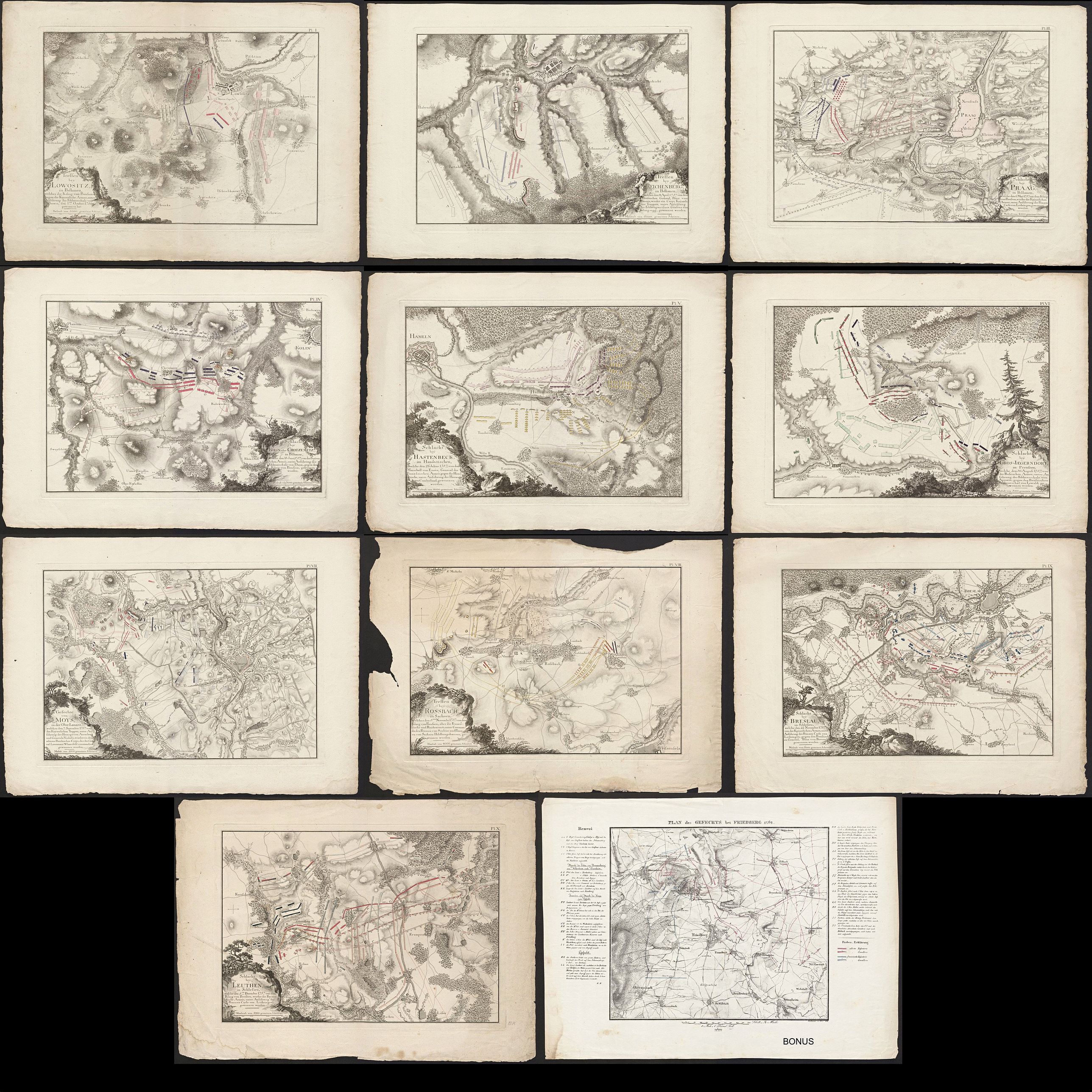
10 battle plans of Seven Years War (1756-1763). |
||||||||||||||||||||
|
||||||||||||||||||||
|
|
||||||||||||||||||||
Estimated value: $300 - $700 |
Virtual Collection - Save and collect your favorite items in one place.
Unless logged in, the item is only saved for that session. If you want to save the items permanently, please Login first Learn more [+] |
|||||||||||||||||||
Description
The Seven Years' War was a global conflict fought between 1756 and 1763. It involved every European great power of the time and spanned five continents, affecting Europe, the Americas, West Africa, India, and the Philippines. The conflict split Europe into two coalitions, led by the Kingdom of Great Britain (including the Kingdom of Prussia, the Kingdom of Portugal, the Electorate of Brunswick-Lüneburg, and other small German states) on one side and the Kingdom of France (including the Austrian-led Holy Roman Empire), the Russian Empire (until 1762), the Kingdom of Spain, and the Swedish Empire on the other.
1. Treffen bey Lowositz in Bohmen / Battle of Lobositz.
The Battle of Lobositz or Lovosice also Lowositz on 1 October 1756 was the opening land battle of the Third Silesian War and the wider Seven Years' War. Frederick the Great's 28,000 Prussians were prevented by 33,000 Austrians under Maximilian Ulysses Count von Browne from continuing their invasion into the rich Bohemian plain, forcing Frederick to ultimately fall back north into Saxony for the winter. (Ref https://en.wikipedia.org/wiki/Battle of Lobositz)
2. Treffen bey Reichenberg, in Bohmen / Battle of Reichenberg.
The Battle of Reichenberg was a battle of the Third Silesian War (part of the Seven Years' War), fought on 21 April 1757 near the town of Reichenberg (Czech: Liberec) in Bohemia. Marshal von Bevern had entered Bohemia with a corps of 16,000 Prussians.
At Reichenberg he encountered Königsegg's Austrian corps. The full Austrian corps consisted of 18,000 infantry and 4,900 cavalry, but only about 10,000 of them had been concentrated at Reichenberg. The experienced Bevern defeated his opponent. As a result, Bevern captured large quantities of Austrian supplies and could continue his march on Prague. (Ref https://en.wikipedia.org/wiki/Battle of Reichenberg.)
3. Schlacht bey Praag in Bohmen / Battle of Prague.
In the Battle of Prague or Battle of Štěrboholy, fought on 6 May 1757 during the Third Silesian War (Seven Years' War), Frederick the Great's 67,000 Prussians forced 60,000 Austrians to retreat, but having lost 14,300 men, decided he was not strong enough to attack Prague. The battle is mentioned in the famous German ballad Lenore written in 1773 by Gottfried August Bürger. (Ref https://en.wikipedia.org/wiki/Battle of Prague (1757).
4. Schlacht bey Kolin oder Chotzemitz in Boehmen / Battle Kolin oder Chotzemitz. (Ref http://www.kronoskaf.com/syw/indexMore maps by Ruscelli. [+]?title=1757-06-18. Battle of Kolin.)
5. Schlacht bey Hastenbeck im Hanovrischen / Battle of Hastenbeck.
The Battle of Hastenbeck (26 July 1757) was fought as part of the Invasion of Hanover during the Seven Years' War between the allied forces of Hanover, Hesse-Kassel (or Hesse-Cassel) and Brunswick, and the French. The allies were defeated by the French army near Hamelin in the Electorate of Hanover. (Ref https://en.wikipedia.org/wiki/Battle of Hastenbeck.)
6. Schlacht bei Gros – Jaegerndorf in Preufsen / Battle of Gross-Jägersdorf.
The Battle of Gross-Jägersdorf (30 August 1757) was a victory for the Russian force under Field Marshal Stepan Fyodorovich Apraksin over a smaller Prussian force commanded by Field Marshal Hans von Lehwaldt, during the Seven Years' War. This was the first battle in which Russia engaged during the Seven Years' War. (Ref https://en.wikipedia.org/wiki/Battle of Gross Jägersdorf.)
7. Gefechte von Moys in der Ober-Lausitz / Battle of Moys.
The Battle of Moys was a battle fought on 7 September 1757 during the Third Silesian War (part of the Seven Years' War). A Prussian army of 13,000 men fought an Austrian army of double their size. The entire Prussian corps surrendered to the Austrians. The battle was fought near Moys in Upper Lusatia, present-day Zgorzelec in Poland. (Ref https://en.wikipedia.org/wiki/Battle of Moys.)
8. Treffen bey Rossbach in Sachsen / Battle of Rossbach.
The Battle of Rossbach took place on 5 November 1757 during the Third Silesian War (1756–1763, part of the Seven Years' War) near the village of Rossbach (Roßbach), in the Electorate of Saxony. Rossbach is considered one of Frederick's greatest strategic masterpieces. He crippled an enemy army twice the size of the Prussian force while suffering negligible casualties. (Ref https://en.wikipedia.org/wiki/Battle of Rossbach.)
9. Schlacht bey Breslau in Schlesien / Battle of Breslau.
The Battle of Breslau (also known as the Battle on the Lohe) was a battle fought on 22 November 1757 during the Third Silesian War (part of the Seven Years' War). A Prussian army of 28,000 men fought an Austrian army of 84,000 men. The Prussians held off the Austrian attack, losing 6,000 men to the Austrians 5,000 men. But one day later the Prussians beat a retreat. Breslau's garrison surrendered on 25 November 1757. (Ref https://en.wikipedia.org/wiki/Battle of Breslau (1757).
10. Schlacht bey Leuthen in Schlefien / Battle of Leuthen.
The Battle of Leuthen was fought on 5 December 1757, at which Frederick the Great's Prussian army used maneuver and terrain to decisively defeat a much larger Austrian force commanded by Prince Charles of Lorraine and Count Leopold Joseph von Daun.
The victory ensured Prussia control of Silesia during the Third Silesian War (part of the Seven Years' War). (Ref https://en.wikipedia.org/wiki/Battle_of_Leuthen.)
Bonus: Plan des Gefechts bei Briedberg 1762.
FAQ - Guarantee - Shipping
Buying in the BuyNow Gallery
This item is available for immediate purchase when a "Add to Cart" or "Inquire Now" button is shown.
Items are sold in the EU margin scheme
Payments are accepted in Euros or US Dollars.
Authenticity Guarantee
 We provide professional descriptions, condition report (based on 45 years experience in the map business)
Paulus Swaen warrants the authenticity of our items and a certificate of authenticity is provided for each acquired lot.
Condition and Coloring
We indicate the condition of each item and use our unnique HiBCoR grading system in which four key items determine a map's value: Historical Importance, Beauty, Condition/Coloring and Rarity.
Color Key
We offer many maps in their original black and white condition. We do not systematically color-up maps to make them more sellable to the general public or buyer.
Copper engraved or wood block maps are always hand colored. Maps were initially colored for aesthetic reasons and to improve readability. Nowadays, it is becoming a challenge to find maps in their original colors and are therefor more valuable.
We use the following color keys in our catalog:
Original colors; mean that the colors have been applied around the time the map was issued.
Original o/l colors; means the map has only the borders colored at the time of publication.
Colored; If the colors are applied recently or at the end of the 20th century.
Read more about coloring of maps [+]
Shipping fee
A flat shipping fee of $ 30 is added to each shipment by DHL within Europe and North America. This covers : International Priority shipping, Packing and Insurance (up to the invoice amount).
Shipments to Asia are $ 40 and rest of the world $50
We charge only one shipping fee when you have been successful on multiple items or when you want to combine gallery and auction purchases.
Read more about invoicing and shipping
FAQ
Please have a look for more information about buying in the BuyNow gallery
Many answers are likely to find in the general help section.
Virtual Collection
![]()
With Virtual Collection you can collect all your favorite items in one place. It is free, and anyone can create his or her Virtual map collection.
Unless you are logged in, the item is only saved for this session. You have to be registed and logged-in if you want to save this item permanently to your Virtual Collection.
Read More[+]
Register here, it is free and you do not need a credit card.
Add this item to
Virtual Collection
or click the following link to see my Virtual Collection.
| High-Resolution Digital Image Download | |
|
Paulus Swaen maintains an archive of most of our high-resolution rare maps, prints, posters and medieval manuscript scans. We make them freely available for download and study. Read more about free image download |
Click this image for a free HR-image download. |
In accordance with the EU Consumer Rights Directive and habitually reside in the European Union you have the right to cancel the contract for the purchase of a lot, without giving any reason.
The cancellation period will expire 14 calendar days from the day after the date on which you or a third party (other than the carrier and indicated by you) acquires, physical possession of the lot. To exercise the right to cancel you must inform Paulus Swaen Europe bv, which is offering to sell the lot either as an agent for the seller or as the owner of the lot, of your decision to cancel this contract by a clear statement (e.g. a letter sent by post, or e-mail (amsterdam@swaen.com).
To meet the cancellation deadline, it is sufficient for you to send your communication concerning your exercise of the right to cancel before the cancellation period has expired.