OOST INDIEN Wassende-Graade Paskaart, vertoonende nevens het Oosterlykste van Afrika, meede de Zeekusten van Asia, van C. de Bona Esperanca tot Eso, boven Iapan.
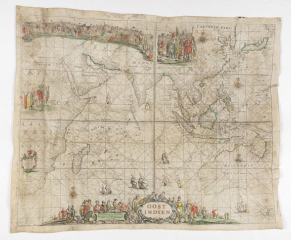
Sea chart of the East Indies on Mercator projection delineating not only the eastern coast of Africa, but also the coasts of Asia, from the C. of Good Hope till Eso, north of Japan.
With address : 't Amsterdam, by Pieter Goos op het Water inde Vergulde Zee-Spiegel seyn nu te Bekoomen by Johannes van Kuelen.
P.O.R.
This chart was first published by Pieter Goos, after which the copper plate passed into the hands of Johannes van Keulen in 1680..
Naming all the Dutch discoveries in Australia, from the first landfall in 1616 and culminating in Abel Tasman's extremely important voyage of 1642-1644.
Showing the territory where the Dutch East India Company V.O.C. was active, from the east of Africa till the western and southern coasts of Australia. These charts were published in the Netherlands for use at sea and the Dutch vessels sailing to and from the Indies were equipped with these charts. Being an important means for navigation, they had to be kept up to date using the latest possible information. Being used on board ship, they were due to perish easily, and the remaining number of copies is therefore very small.
Engraved sea chart printed on vellum.
Interestingly, the chart has a misspelling of the name : van Kuelen instead of van Keulen. This fact is only mentioned by prof. Gunter Schilder in The van Keulen Cartography, Appendix 5, 211, page 186, however, does not mention the additional soundings and text in West Australia.
A most embellished map of the East Indies, showing the coastline of Australia as established by Abel Tasman in 1644.
This chart was first published by Pieter Goos c. 1660. Schilder notes that "this map contains a complete survey of Dutch expansion in the East Indies and takes into account Tasman's two voyages of exploration".
The plates for this and other of Goos's charts passed to Johannes van Keulen, the pre-eminent Dutch maritime publisher of the next generation, who sometimes included these oversize charts in his sea-atlases.
The map appears very infrequently on the market.
This chart is very interesting as it is updated along Australia's West coast. Extensive soundings are added offshore of present-day the coast of Geraldton, Western Australia.
Beside this the following text is added where we find present-day Perth : Duinig land boven Lage Ruigte Gelijk Verdronk Boomen en Boschaghe a text also used by Hessel Gerritsz, but only now inserted.
The update of the soundings was very important as many Dutch ships were shipwrecked at the West Australian coast.
The VOC flagship Batavia (1629), under the command of Commander Francois Pelsaert, was wrecked on the Abrolhos Islands, just 60 kilometers off the coast of Geraldton, Western Australia.
The Ridderschap van Holland (1694) was shipwrecked on the west coast, probably on the Abrolhos Islands. The VOC dispatched a fleet under Willem Vlamingh to search for survivors. There were none found. Could it be that Van Keulen added after this event the soundings to his chart !
An advertisement of sea atlases, pilot books, charts, etc. sold by Joh. van Keulen, printed in the "Zee-Alas" of 1695 is known and mentions "als meede vier groote Paskaarten op Perkement, die voor desen Pieter Goos totsijn gebruyk gehad heeft, te weten OostIndien Wassende graden, ... (See Atlantes Neerlandici, Volume 4, page 278, Y). Interestingly the re-issued Goos/van Keulen charts were used on ships of the British and French East India Company, as late as the 1740.
