Subscribe to be notified if similar examples become available.
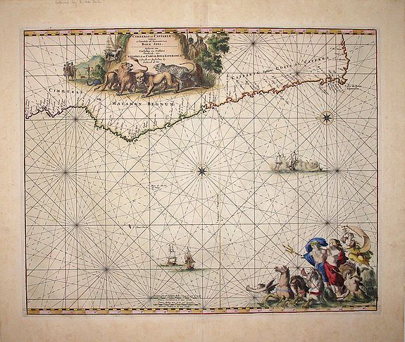
Cimebebas and Caffaria from Catembela to the Cape of Good Hope: Cimebebas et Caffariae Littora a Catenbela ad Promontorium Bonae Spei Pascaerte................ |
||||||||||||||||||||
|
||||||||||||||||||||
|
|
||||||||||||||||||||
Estimated value: $1950 - $2900 |
Virtual Collection - Save and collect your favorite items in one place.
Unless logged in, the item is only saved for that session. If you want to save the items permanently, please Login first Learn more [+] |
|||||||||||||||||||
Description
This sea-chart was first published in De Wit's Orbis Maritmus ofte Zee Atlas of 1675 and also appeared in later editions.
De Wit's sea charts from this atlas are sought after for their geographical content as well as their attractive cartouches and vignettes.
A large title cartouche dominates the top of the chart. This cartouche shows lions, leopards, and other African animals. The left of the cartouche shows a group of Europeans negotiating with Africans; figures of Africans are also shown. The bottom right vignette has Neptune and a female figure surrounded by cherubs and drawn by three horses. Several sea battles are also depicted.
The copperplate for this sea chart was acquired by Louis Renard in the early 1700s. The imprint was changed from De Wit to that of Renard.
What makes this map very special is that it was probably colored by the master colorist Dirk Jansz van Santen (1637/38-1708). In the seventeenth century, the Netherlands held a prominent position in Europe in the production of books, maps and prints. Not only were the number, diversity and quality of printed works renown, but also the "versiering" - the application of decorative graphic elements in the coloring of maps, prints, title pages, opening and closing vignettes, etc.
Little is known about the many print and map colorists, the 'consten caertafzetters', who lived in the Netherlands at the time. Since their work was usually not signed, they have remained anonymous. The most important exception to this rule is Dirk Jansz van Santen.
Atlases and books colored by Van Santen figured among the showpieces of the most prominent collections, such as that of the Amsterdam burgomaster Nicolaas Witsen (1641-1717) or of Laurens van der Hem (1621-1678), a wealthy Amsterdam lawyer. Bibles and atlases, bound in deluxe bindings by Albert Magnus (16421689) and decorated by Van Santen were considered gifts worthy of princes. Travellers and poets wrote about his work.
There is a reference to him in the travel account of Zacharias Konrad von Uffenbach, Merkwürdige Reisen... (Ulm, 1750-54). Von Uffenbach was the burgomaster of Frankfurt and an art collector who left a record of his visit to Amsterdam in 1711 which makes it clear that collectors competed with each other to obtain the best of what Van Santen had made.
This chart is lavishly colored using gold for the cartouches and further embellishments and major cities. The scale of longitude and latitude in variations of red, blue-green, alternating with gold for a lively effect.
The figures around the figure of Neptune at the bottom right are painted in a somewhat impressionistic way that is characteristic of Van Santen with many dark shadow areas to highlight the colors.
More about the Dutch master colorist Dirk Jansz van Santen. [+]
Reference: Norwich Map #254 for the Renard sea chart. Tooley [under De Witt], p. 124. Z.K. von Uffenbach, Merkwüdige Reisen durch Niedersachsen, Holland und Engelland, 3 vols., Ulm 1750-1754, vol. 3, pp. 600-606. Goedings, Truusje, Dirk Jansz van Santen:
FAQ - Guarantee - Shipping
Buying in the BuyNow Gallery
This item is available for immediate purchase when a "Add to Cart" or "Inquire Now" button is shown.
Items are sold in the EU margin scheme
Payments are accepted in Euros or US Dollars.
Authenticity Guarantee
 We provide professional descriptions, condition report (based on 45 years experience in the map business)
Paulus Swaen warrants the authenticity of our items and a certificate of authenticity is provided for each acquired lot.
Condition and Coloring
We indicate the condition of each item and use our unnique HiBCoR grading system in which four key items determine a map's value: Historical Importance, Beauty, Condition/Coloring and Rarity.
Color Key
We offer many maps in their original black and white condition. We do not systematically color-up maps to make them more sellable to the general public or buyer.
Copper engraved or wood block maps are always hand colored. Maps were initially colored for aesthetic reasons and to improve readability. Nowadays, it is becoming a challenge to find maps in their original colors and are therefor more valuable.
We use the following color keys in our catalog:
Original colors; mean that the colors have been applied around the time the map was issued.
Original o/l colors; means the map has only the borders colored at the time of publication.
Colored; If the colors are applied recently or at the end of the 20th century.
Read more about coloring of maps [+]
Shipping fee
A flat shipping fee of $ 30 is added to each shipment by DHL within Europe and North America. This covers : International Priority shipping, Packing and Insurance (up to the invoice amount).
Shipments to Asia are $ 40 and rest of the world $50
We charge only one shipping fee when you have been successful on multiple items or when you want to combine gallery and auction purchases.
Read more about invoicing and shipping
FAQ
Please have a look for more information about buying in the BuyNow gallery
Many answers are likely to find in the general help section.
Virtual Collection
![]()
With Virtual Collection you can collect all your favorite items in one place. It is free, and anyone can create his or her Virtual map collection.
Unless you are logged in, the item is only saved for this session. You have to be registed and logged-in if you want to save this item permanently to your Virtual Collection.
Read More[+]
Register here, it is free and you do not need a credit card.
Add this item to
Virtual Collection
or click the following link to see my Virtual Collection.
| High-Resolution Digital Image Download | |
|
Paulus Swaen maintains an archive of most of our high-resolution rare maps, prints, posters and medieval manuscript scans. We make them freely available for download and study. Read more about free image download |
Click this image for a free HR-image download. |
In accordance with the EU Consumer Rights Directive and habitually reside in the European Union you have the right to cancel the contract for the purchase of a lot, without giving any reason.
The cancellation period will expire 14 calendar days from the day after the date on which you or a third party (other than the carrier and indicated by you) acquires, physical possession of the lot. To exercise the right to cancel you must inform Paulus Swaen Europe bv, which is offering to sell the lot either as an agent for the seller or as the owner of the lot, of your decision to cancel this contract by a clear statement (e.g. a letter sent by post, or e-mail (amsterdam@swaen.com).
To meet the cancellation deadline, it is sufficient for you to send your communication concerning your exercise of the right to cancel before the cancellation period has expired.