Browse Listings in Asia > Near / Middle East
![.[Pakistan, Afghanistan]](/uploads/cache/33849-250x250.jpg)
.[Pakistan, Afghanistan]
Wood block printed Ptolemaic map of the region of present-day Pakistan and part of Afghanistan. Convoluted mountain ranges and river systems dominate the trapezoidal map....
Date: Vienna, Trechsel, G., 1525 -1541
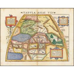
Tabula Asiae VII.
Attractive woodblock map, depicting the Caspian Sea, Black Sea and the Persian Gulf, extending to the Imaus Mountains. according to Ptolemy. In the center of the map is...
Date: Basle, 1542
![Tabula Asiae III [Black & Caspian Sea Region]](/uploads/cache/41831-250x250.jpg)
Tabula Asiae III [Black & Caspian Sea Region]
Attractive woodblock Ptolemaic map, depicting Armenia and in the Right part of the Caspian Sea with Noes Arch, believed to have come to rest in a mountain in Armenia acco...
Date: Basel, Heinrich Petri, 1545
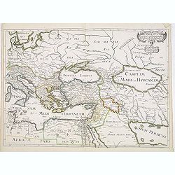
Romani Imperii Oriens est Descriptio Geographica. . .
A fine map of the Near East. The map was first published by Tavernier and later by Mariette. This edition is dated 1637 with the address of Pierre Mariette at rue S. Jacq...
Date: Paris, after 1637
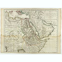
Carte de L'Egypte de la Nubie de L'Abissinie..
Including the Arabian Peninsula. Giving good detail on Egypt. Engraved by Desrosiers. Address and date changed, now with the imprint "A Paris Chez l’Auteur sur le ...
Date: Paris, November 1707
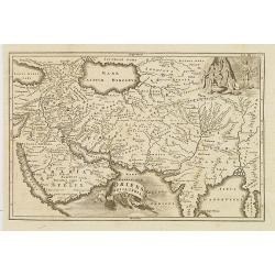
Oriens, Persia, India etc.
Uncommon map of Persia, Armenia, Arabian Peninsular and part of India. Prepared by Christoph Cellarius (1638-1707). From Geographia Antiqua...
Date: Leipzig, Gledisch, 1732
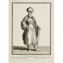
Emir Fechrredin prince des Drus.
Engraving published by Nicolas Bonnart (c.1637 - 1718), engraver in Augsburg since 1719. Before the nineteenth century, portraits of rulers in the Middle East were a rari...
Date: Paris, ca. 1740
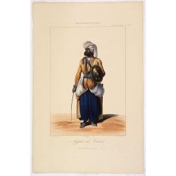
AFGHAN de CABOULE. Costumes Persans 8.
A beautiful hand colored lithograph of an elegant Afghan from Kabul published in the French work "Galerie Royale de Costumes peints d´après nature par divers artis...
Date: Paris, Chez Aubert & Cie., 1842-1848

Carte géologique détaillée. Beyrouth.
Geological or soil map showing part of Lebanon with Beyrouth, including in top a colored legend with signs of the different geological ages. Provenance : Fondation P. Fal...
Date: Liban, Service geographique des F.F.L., 1945

Carte géologique détaillée. Jezzîne.
Geological or soil map showing part of Lebanon with Jezzîne, including a legend with signs of the different geological ages and giving many information of greatest inter...
Date: Liban, Service geographique des F.F.L., 1945

Carte géologique détaillée. Râchaïya Nord.
Geological or soil map showing part of Lebanon with Râchaïya , including a legend with signs of the different geological ages and giving many informations of greatest i...
Date: Liban, Service geographique des F.F.L., 1945

Carte géologique détaillée. Zahle.
Geological map showing part of Lebanon with Zahle. , including a legend with signs of the different geological ages. Provenance : Fondation P. Fallot
Date: Liban, Service geographique des F.F.L., 1945

Carte geologique detaillee. Jbail.
Geological or soil map showing part of Lebanon with Jbail antique Byblos Ancien Port phenicien / scale 1 : 50 000., including a legend with signs of the different geologi...
Date: Liban, Service geographique des F.F.L., 1945
