Browse Listings in Asia > Tartary / Siberia

Tartaria.
Published in Hondius' editions of the Mercator Atlas from 1606 onwards, China, Korea, and the northern Pacific coast of America are shown as two continents separated by t...
Date: Amsterdam, 1633

Noordoost Cust van Asia van Japan tot Nova Zembla.
Important for its early depiction of Hokkaido and the Islands to the North of Japan. Ships navigate the seas around the Siberian, Chinese and Japanese coast extending as ...
Date: Amsterdam, 1666
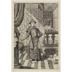
Impery sino Tartarici Supremus Monarcha.
Decorative costume plate showing Kam Hi son of the Shunzhi Emperor of China [1638 - 1661?], the second emperor of the Manchu Qing dynasty, who apparently supported the fo...
Date: Amsterdam, 1668
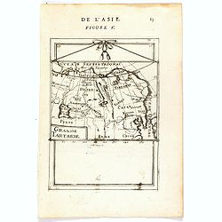
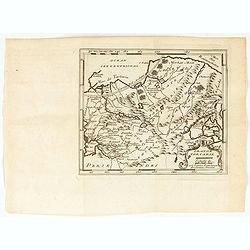
Grande Tartarie (de L'Asie / Figure V).
A fine and uncommon early 17th century map of Tartary with Korea. and the name USBECK showing in present-day Usbekistan.From the French text edition of "Description ...
Date: Paris, 1683

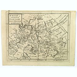
Great or Asiatick Tartary, Agreable to Modern History.
Map of Tartary to Peking. The eastern coastline of Asia is almost flat, with no attempt to mark Kamchatka. The Caspian Sea in the lower left, with present-day Uzbekistan...
Date: London, 1727
Great or Asiatick Tartary, Agreeable to Modern History.
A map from the Frozen Ocean in the north to Usbec Tartary in the south, from Moscow in the west to China Tartary and Peking in the east. Rivers and mountains feature prom...
Date: London, ca. 1727
Historic Map - Naaukeurige Kaart Van Tartaryen, Soo als dat door W De Rubruquis doorreyst.
This attractive map published by Pieter van der Aa, shows Tartary abd the ancient Silk Road region. The map shows the track of William of Rubruck (Willem van Rubroeck or ...
Date: Amsterdam, 1713-1729
Grande Tartarie.
A very nice small map of Central Asia extending from the Caspian Sea to the Pacific Ocean. From Francisco Giustiniani for El Atlas abreviado o el nuevo compendio de la Ge...
Date: Leon de Francia (Lyon), Jaime Certa, 1739
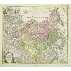
Imperii Russici et Tartariae Universae tam majoris Afiaticæ quam minoris et EuropæTabula.
The map is of interest for the use of East Sea, the sea between Korea and Japan, here called "Mere Orientale Minus".Decorative map covering Russia, Tibet, China...
Date: Nuremberg, 1739
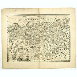
A New and Accurate Map of the Whole Russian Empire as contained both in Europe and Asia. . .
Detailed map of Russia, from the Sea of Anadyr, Sea of Kamchatka and the Kuril Islands to St.Petersburg. Also includes Tibet, Korea and part of China, with the Great Wa...
Date: London, c. 1747
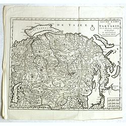
Nieuwe kaart van Tartarie. . .
A map of Tartary, Korea and part of Japan. Map place names in Korea are marked. The map is most notable for the confusion between Kamchatka and Jesso.The Caspian Sea in t...
Date: Amsterdam, 1731 / 1750
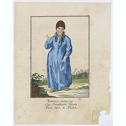
Femme tatares de Tchatsk.
Uncommon copper-engraved costume plate from the French translation of Johann Gottlieb Georgi's "Beschreibung aller Nationen des Russischen Reichs" (1776), the w...
Date: St. Petersbourg, C.G. Müller, 1776-1777
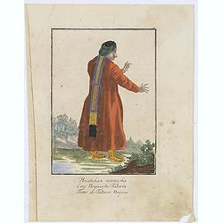
Femme de Tatares Nogais.
Uncommon copper-engraved costume plate from the French translation of Johann Gottlieb Georgi's "Beschreibung aller Nationen des Russischen Reichs" (1776), the w...
Date: St. Petersbourg, C.G. Müller, 1776-1777

Carte des parties Nord et est de l'Asie..
Five maps on one sheet show the Northern Russian territories in Europe and Asia, including the western coastline from Siberia, Japan, and Korea with the island of "Q...
Date: Paris, 1779
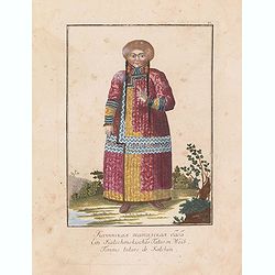
Femme tatare de Katchin.
Uncommon copper-engraved costume plate from Johann Gottlieb Georgi "Beschreibung aller Nationen des russischen Reichs" (1776), the work stands out for the hand-...
Date: St. Petersbourg, C.G. Müller, 1776-1780
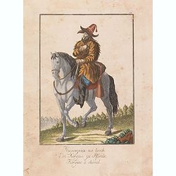
Kirgise à cheval.
Uncommon copper-engraved costume plate from Johann Gottlieb Georgi "Beschreibung aller Nationen des russischen Reichs" (1776), the work stands out for the hand-...
Date: St. Petersbourg, C.G. Müller, 1776-1780
![Une Kirguisiene par devant. [together with] Une Kirguisienne par derriere.](/uploads/cache/32991-250x250.jpg)
Une Kirguisiene par devant. [together with] Une Kirguisienne par derriere.
1780 - ROTH, Ch. M. Two costume plates showing natives of Kyrgyzstan
Date: St. Petersbourg, C.G. Müller, 1776-1780
![Femme tatare à Kousnetsk par devant. [together with] Femme tatare à Kousnetsk par derriere.](/uploads/cache/32990-250x250.jpg)
Femme tatare à Kousnetsk par devant. [together with] Femme tatare à Kousnetsk par derriere.
Uncommon copper-engraved costume plate from Johann Gottlieb Georgi "Beschreibung aller Nationen des russischen Reichs" (1776), the work stands out for the hand-...
Date: St. Petersbourg, C.G. Müller, 1776-1780
![Fille tatare à Kousnetsk par devant. [together with] Fille tatare Kousnetsk par derriere.](/uploads/cache/32988-250x250.jpg)
Fille tatare à Kousnetsk par devant. [together with] Fille tatare Kousnetsk par derriere.
Uncommon copper-engraved costume plate from Johann Gottlieb Georgi "Beschreibung aller Nationen des russischen Reichs" (1776), the work stands out for the hand-...
Date: St. Petersbourg, C.G. Müller, 1776-1780
![Un Jacout en habit de chasse par devant [together with] Un Jakout en habit de chasse par derriére.](/uploads/cache/32986-250x250.jpg)
Un Jacout en habit de chasse par devant [together with] Un Jakout en habit de chasse par derriére.
Uncommon copper-engraved costume plate from Johann Gottlieb Georgi "Beschreibung aller Nationen des russischen Reichs" (1776), the work stands out for the hand-...
Date: St. Petersbourg, C.G. Müller, 1776-1780
![Fille Jakoute par derrière [together with] Fille Jakoute par devant.](/uploads/cache/32985-250x250.jpg)
Fille Jakoute par derrière [together with] Fille Jakoute par devant.
Uncommon copper-engraved costume plate from Johann Gottlieb Georgi "Beschreibung aller Nationen des russischen Reichs" (1776), the work stands out for the hand-...
Date: St. Petersbourg, C.G. Müller, 1776-1780
![Fille Jakoute par derrière [together with] Fille Jakoute par devant.](/uploads/cache/32984-250x250.jpg)
Fille Jakoute par derrière [together with] Fille Jakoute par devant.
Uncommon copper-engraved costume plate from Johann Gottlieb Georgi "Beschreibung aller Nationen des russischen Reichs" (1776), the work stands out for the hand-...
Date: St. Petersbourg, C.G. Müller, 1776-1780

La Tartaria Chinese.
With decorative title cartouche. Covering north eastern part of China, Korea and Hokkaido (here called Jeso-Gasima, Tartary including the Gobi Desert; also Peking and the...
Date: Venice, 1784

La Tartaria Chinese.
With decorative title cartouche. Covering north eastern part of China, with good detail in Korea and a curious shape for Hokkaido (here called Jeso-Gasima ).Engraved by G...
Date: Venice, 1784

The Russian Empire in Europe and Asia . . .
Detailed map of the whole of Russia, extending from Poland to the Pacific and from Nova Zembla to Tartaria.The map is of interest for the use of Corea Gulf for the sea be...
Date: London, 1790

Siberie ou Russie Asiatique, Tartarie Chinoise, Pays des Eluts et Isles du Japon.
Map of the Kamchatka peninsula, Russian Far East., Korea, Japan, with Hokkaido labeled "Terre del Jeso".By C. F. Delamarche, successor of Robert de Vaugondy, Ge...
Date: Paris, 1794 - 1806
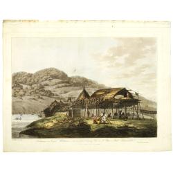
Balagans or summer habitations, with the method of drying fish at St. Peter and Paul, Kamtschatka.
Balagans or summer habitations, with the method of drying fish at St. Peter and Paul, Kamtschatka, taken from "Views in the South Seas" being a very important a...
Date: London, Boydell and Co., 1808

The Narta, or Sledge for burdens in Kamtschatka.
Webber's view of transport in Kamtchatka, Russia, showing the sledge dogs hooked up to the sledge, and their master on skis, taken from "Views in the South Seas"...
Date: London, Boydell and Co., 1808

Siberia & Central Asia.
This map covers the eastern section of Russia as well as China, Japan, Korea, India and Tibet. The map is of interest for the use of Sea of Corea, the sea between Korea a...
Date: Boston, 1835
![[Tartary - Russia]](/uploads/cache/44310-250x250.jpg)
[Tartary - Russia]
Postcard size map in Ottoman script showing Siberia prepared by Mehmet EŞREF in a small atlas : عمومولاياةىشهانيىحاوىكوچكاطلاس [Umum-i vil...
Date: Istanbul, 1325 or 1909
