Please login to see price!.
Subscribe to be notified if similar examples become available.
Geografia di Claudio Tolomeo Alessandrino Tradotta di Greco nell'Idioma Volgare Italiano da Girolamo Ruscelli |
||||||||||||||||||||
|
||||||||||||||||||||
|
|
||||||||||||||||||||
|
Selling price: $...
Please login to see price! Sold in 2010 Missed this item! Add your name to our mailing list and be the first to get notified about our newly added listings. . |
Collection - Save and collect this or any of your favorite items in one place.
If you want to save the items permanently, please sign in or create account first. |
|||||||||||||||||||
Description
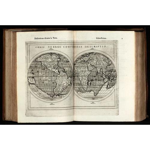
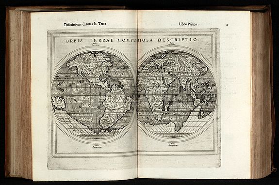
Sixth edition of Ruscelli's translation of Ptolemy's Geografia edited and extended by Giuseppe Rosaccio published by the Hires of M. Sessa in 1598 and 1599.
Illustrated with 69 double page engraved maps and several woodcuts in the text. Whereof 27 Ptolemy maps and 42 'modern' map, including 4 world maps (one Ptolemy /Shirley 133, three modern /Shirley 110, 111, 217), 7 maps of America (Western Hemisphere, South America, Mexico with Florida, Brazil, east coast of North America, Haiti, Cuba), 28 European maps (including the North-Atlantic map with parts of Labrador), 10 maps of Africa and 20 maps of Asia.
The Valgrisi copper plates of the earlier Ruscelli editions have been revised by Rosaccio and extended by five new plates. Most of the Ptolemy and Modern maps have been extended by cute illustrations as ships, sea monsters, fishes, trees, figures and with additional place names. Rosaccio did not forget the geographical relation and reference to the text in the maps. A morbid example can be found on the Brazil map, where R. underlined the text 'Gli indi natij di questi paesi mangiano carne humana' (The Indians of these countries eat human meat) by a cannibal illustration. Another interesting addition is the southern continent on the modern world map (Shirley 110, now 2nd state). The second modern world map (Shirley 217) is almost certainly from Rosaccio himself. Shirley mentioned 'the engraving is sharp and neat, and is a skilful reduction of Rumold Mercator's map of 1587 but with parallel latitudinals'. In addition to the new world map, R. added continent maps of America (Burden 86), Asia, Africa and Europe.
Reference: Shirley T.PTOL-10f/g
FAQ - Guarantee - Shipping
Buying in the BuyNow Gallery
This item is available for immediate purchase when a "Add to Cart" or "Inquire Now" button is shown.
Items are sold in the EU margin scheme
Payments are accepted in Euros or US Dollars.
Authenticity Guarantee
 We provide professional descriptions, condition report (based on 45 years experience in the map business)
Paulus Swaen warrants the authenticity of our items and a certificate of authenticity is provided for each acquired lot.
Condition and Coloring
We indicate the condition of each item and use our unnique HiBCoR grading system in which four key items determine a map's value: Historical Importance, Beauty, Condition/Coloring and Rarity.
Color Key
We offer many maps in their original black and white condition. We do not systematically color-up maps to make them more sellable to the general public or buyer.
Copper engraved or wood block maps are always hand colored. Maps were initially colored for aesthetic reasons and to improve readability. Nowadays, it is becoming a challenge to find maps in their original colors and are therefor more valuable.
We use the following color keys in our catalog:
Original colors; mean that the colors have been applied around the time the map was issued.
Original o/l colors; means the map has only the borders colored at the time of publication.
Colored; If the colors are applied recently or at the end of the 20th century.
Read more about coloring of maps [+]
Shipping fee
A flat shipping fee of $ 30 is added to each shipment by DHL within Europe and North America. This covers : International Priority shipping, Packing and Insurance (up to the invoice amount).
Shipments to Asia are $ 40 and rest of the world $50
We charge only one shipping fee when you have been successful on multiple items or when you want to combine gallery and auction purchases.
Read more about invoicing and shipping
FAQ
Please have a look for more information about buying in the BuyNow gallery
Many answers are likely to find in the general help section.
Collection
![]()
With Collection you can collect all your favorite items in one place. It is free, and anyone can create his or her Virtual map collection.
Unless you are logged in, the item is only saved for this session. You have to be registed and logged-in if you want to save this item permanently to your Virtual Collection.
Read More[+]
Register here, it is free and you do not need a credit card.
Add this item to
Virtual Collection
or click the following link to see my Collection.
| Digital Image Download | |
|
Paulus Swaen maintains an archive of most of our high-resolution rare maps, prints, posters and medieval manuscript scans. We make them freely available for download and study. Read more about free image download |
Click the image for a free small image download. |
In accordance with the EU Consumer Rights Directive and habitually reside in the European Union you have the right to cancel the contract for the purchase of a lot, without giving any reason.
The cancellation period will expire 14 calendar days from the day after the date on which you or a third party (other than the carrier and indicated by you) acquires, physical possession of the lot. To exercise the right to cancel you must inform Paulus Swaen Inc, of your decision to cancel this contract by a clear statement (e.g. a letter sent by post, or e-mail (amsterdam@swaen.com).
To meet the cancellation deadline, it is sufficient for you to send your communication concerning your exercise of the right to cancel before the cancellation period has expired.
