Search Listings matching "cyprus"
![.[Near east with Cyprus]](/uploads/cache/33857-250x250.jpg)
.[Near east with Cyprus]
Wood block printed map and one of earliest printed representation of Near east with Cyprus prepared by Martin Waldseemüller. Based on the slightly larger map from 1513 p...
Place & Date: Vienna, 1525 -1541
![[Map of the Holy Land, including Cyprus]](/uploads/cache/33436-250x250.jpg)
[Map of the Holy Land, including Cyprus]
Attractive full page longitudinal map of Palestine, Syria and Cyprus, cut by Hans Rudolf Manuel Deutsch. The shore line running from Southern Anatolia to the Nile Delta. ...
Place & Date: Basle, 1550-1580

Tafel der Lender darin der Apostel Paulus geprediget hat.
Rare wood block map depicting the Mediterranean, with an over-sized Cyprus from the final Dutch edition of Heinrich Bünting's famous Itinerarium Sacrae Scripturae, a boo...
Place & Date: Magdeburg, 1581

Peregrinationis Divi Pauli Typus corographicus. . .
A splendid map depicting the travels of Paulus. With two fine scenes in top. Showing the countries along the Mediterranean, including Cyprus and Italy. A first edition wi...
Place & Date: Antwerp, 1595

Metileme. (Lesbos)
Very rare map of Lesbos published in the first edition of "Viaggio da Venetia, a Costantinopoli. Per Mare, e per Terra, & infieme quello di Terra Santa. Da Giose...
Place & Date: Venice, Giacomo Franco, 1598

Scio. (Chios)
Very rare view of Chios Island published in the first edition of "Viaggio da Venetia, a Costantinopoli. Per Mare, e per Terra, & infieme quello di Terra Santa. D...
Place & Date: Venice, Giacomo Franco, 1598

Quella Tavola E l'Antica Siria ch'Era destinta in dodici . . .
Very rare view of Holy Land published in the first edition of "Viaggio da Venetia, a Costantinopoli. Per Mare, e per Terra, & infieme quello di Terra Santa. Da G...
Place & Date: Venice, Giacomo Franco, 1598
![Venetia. [Venice ]](/uploads/cache/45176-250x250.jpg)
Venetia. [Venice ]
Scarce view of Venice published in the first edition of "Viaggio da Venetia, a Costantinopoli. Per Mare, e per Terra, & infieme quello di Terra Santa. Da Giosepp...
Place & Date: Venice, Giacomo Franco, 1598
![[ Map of the island Nexos]](/uploads/cache/45289-250x250.jpg)
[ Map of the island Nexos]
Very rare map of the island Naxos published in the first edition of "Viaggio da Venetia, a Costantinopoli. Per Mare, e per Terra, & infieme quello di Terra Santa...
Place & Date: Venice, Giacomo Franco, 1598
![[View of Gulf of Trieste].](/uploads/cache/45191-250x250.jpg)
[View of Gulf of Trieste].
Very rare view of Gulf of Trieste published in the first edition of "Viaggio da Venetia, a Costantinopoli. Per Mare, e per Terra, & infieme quello di Terra Santa...
Place & Date: Venice, Giacomo Franco, 1598
![[Map of Corfu. View of the city of Corfu on the foreground. ]](/uploads/cache/45221-250x250.jpg)
[Map of Corfu. View of the city of Corfu on the foreground. ]
Very rare map of Corfu with a view of the city of Corfu on the foreground. Published in the first edition of "Viaggio da Venetia, a Costantinopoli. Per Mare, e per T...
Place & Date: Venice, Giacomo Franco, 1598
![Rhodi [Map of Rhodes]](/uploads/cache/45235-250x250.jpg)
Rhodi [Map of Rhodes]
Very rare map of Rhodes Island published in the first edition of "Viaggio da Venetia, a Costantinopoli. Per Mare, e per Terra, & infieme quello di Terra Santa. D...
Place & Date: Venice, Giacomo Franco, 1598

Santorini.
Very rare map of Santorini published in the first edition of "Viaggio da Venetia, a Costantinopoli. Per Mare, e per Terra, & infieme quello di Terra Santa. Da Gi...
Place & Date: Venice, Giacomo Franco, 1598
![[A unique, made-to-order edition, of the Parergon, in quo Veteris geographiae aliquot tabulae.]](/uploads/cache/49049ZG-250x250.jpg)
[A unique, made-to-order edition, of the Parergon, in quo Veteris geographiae aliquot tabulae.]
This is a unique, made-to-order atlas of Ortelius's Atlas, "Parergon" or "Atlas of the ancient world." In 1579, Ortelius published his first Parergon ...
Place & Date: Antwerp, ca. 1601-1640
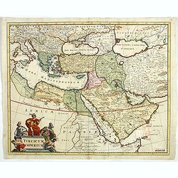
Turcicum Imperium.
Detailed map of the Turkish Empire by Holland's leading mapmaker at the end of the seventeenth century. The cartouche shows an Ottoman administrator or possibly the Sulta...
Place & Date: Amsterdam, 1680

Nova Persiae Armeniae Natoliae et Arabiae.
This fine map shows the area East from Cyprus to Iran, including The Saudi Peninsula, Red Sea, Nile River, Cyprus, Asia Minor, the Gulf of Aden, the Indian Ocean, Armenia...
Place & Date: Amsterdam, 1680

A unique composite atlas with updated Porro maps.
Unique composite atlas containing in total 84 maps - 82 maps engraved by Girolamo Porro and heavenly reworked around 1686 and 2 newly engraved maps; Piccola Tartaria (Cr...
Place & Date: Venice, 1686

A Map of the Environs of Constantinople Drawn from a great number of accurate astronomical & geographical manuscripts and printed documents, by A. Arrowsmith 1801 and 1804.
Arrowsmith’s large and detailed map of the Ottoman Empire and the Black Sea, with Cyprus, Crete and the Greek Islands in the Mediterranean Sea, Albania, Bosnia and Herz...
Place & Date: London, No.10 Soho Square, 4th September 1804