Search Listings matching "cyprus"
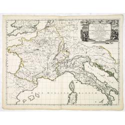
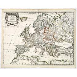
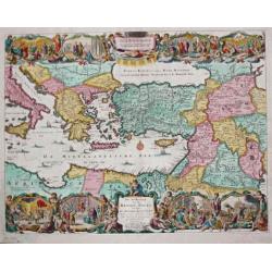
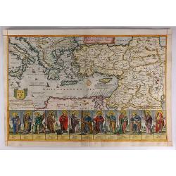
Geographia Synodica, Sive Regionum, Vrbium, et Locorum vbi Celebrata Sunt Concilia Oecumenica, Nationalia, Provincialia et Synodi Dioecesanae
Attractive historical map of Europe, the Mediterranean, and northern Africa. Extends to Cyprus and the Holy Land. Based on the cartography of Guillaume Samson and publish...
Place & Date: Paris, 1666
Selling price: $75
Sold in 2020
Geographia Synodica, Sive Regionum, Vrbium, et Locorum vbi Celebrata Sunt Concilia Oecumenica, Nationalia, Provincialia et Synodi Dioecesanae
Attractive historical map of Europe, the Mediterranean, and northern Africa. Extends to Cyprus and the Holy Land. Based on the cartography of Guillaume Samson and publish...
Place & Date: Paris, 1666
Selling price: $100
Sold in 2016
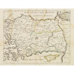
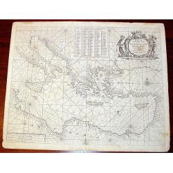
Mer Noire ou Mer Maievre . . .
Map encompassing part of the Near East and the area comprehended between the Black Sea and the Caspian Sea. Centered on Turkey and Cyprus prepared by N.Sanson and publish...
Place & Date: Paris, P. Mariette, 1667
Selling price: $30
Sold in 2011
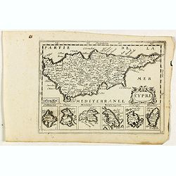
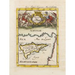
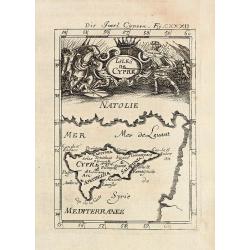
Cypre.
Rare map of Cyprus with decorative title cartouche. Below six small inset maps of Greek islands at bottom of page published by Jollain in 1667. Published in "Trésor...
Place & Date: Paris, 1667
Selling price: $550
Sold in 2018
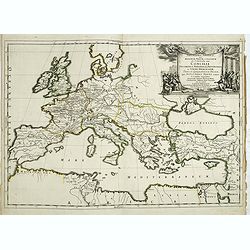
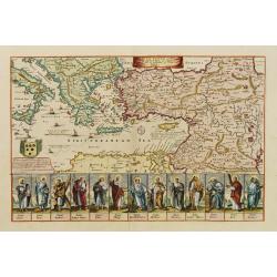
Europa Vetus.
Attractive historical map of Europe, the Mediterranean, and northern Africa. Extends to Cyprus and the Holy Land. Based on the cartography of Guillaume Samson and publish...
Place & Date: Paris, 1668
Selling price: $135
Sold in 2013
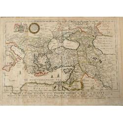
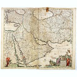
A MAPP of THE ESTATES of the TURKISH EMPIRE in ASIA, and EUROPE.
Uncommon antique map of the Eastern Mediterranean, Italy, Sicily, Cyprus, Turkey, the Black Sea & Caucasus, the Holy Land and Iraq, published in Blome's 'A Geographic...
Place & Date: London, 1669
Selling price: $250
Sold in 2014
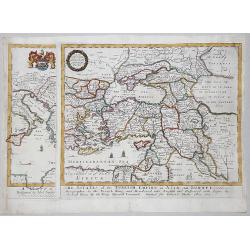
A MAPP of THE ESTATES of the TURKISH EMPIRE in ASIA, and EUROPE, 1669
A rare map of Turkey, Asia Minor, Cyprus, North Africa, Crimea, Southern part of Italy and Eastern Europe . This rare example is the earliest folio sized map of the regio...
Place & Date: London, 1669
Selling price: $350
Sold in 2020
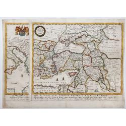
A MAPP of THE ESTATES of the TURKISH EMPIRE in ASIA, and EUROPE, 1669.
A copperplate partly colored map showing Arabie, Asia Minor & Cyprus. This rare example is the earliest folio sized map of the region to be engraved in England by Ric...
Place & Date: London, 1669
Selling price: $435
Sold in 2019
Pas Kaert der Middelandsche.
Companion sea chart of lot 15518 from Doncker?s Nieuw Groot Stuurmans Straets-Book depicting eastern half of Mediterranean covering Italy and Cyprus and entire eastern sh...
Place & Date: Amsterdam 1670
Selling price: $755
Sold
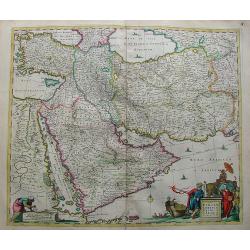
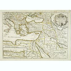
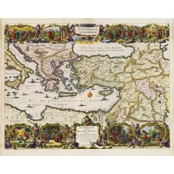
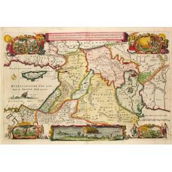
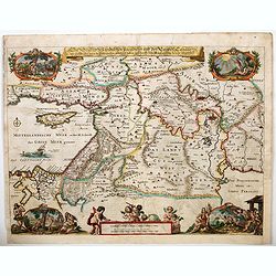
Nova Persiae Armeniae Natoliae et Arabiae.
Decorative map of Persia with Cyprus.
Place & Date: Amsterdam, 1670
Selling price: $500
Sold in 2010
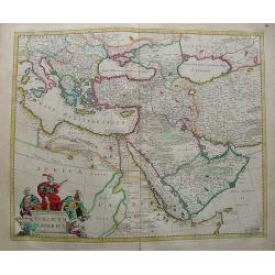
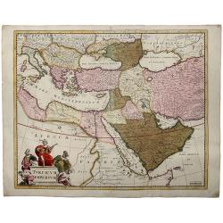
Turicum Imperium.
Attractive map of Turkey, Arabia, Persia and the east Mediterranean region, including Cyprus.
Place & Date: Amsterdam, 1670
Selling price: $615
Sold in 2010
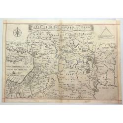
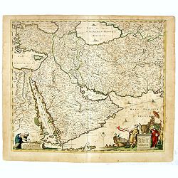
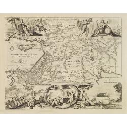
Paradise or the Garden of Eden with the Countries Circumjacent Inhabited by the Patriarchs.
An attractive, detailed map of the middle East region around the Paradise and Garden of Eden, extending from Cyprus to the Persian Sea. The Garden of Eden is located in t...
Place & Date: Amsterdam, ca. 1670
Selling price: $113
Sold in 2020
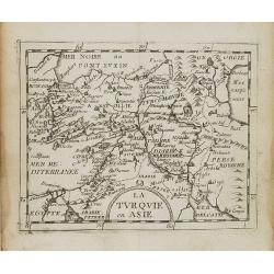
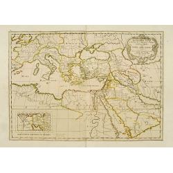
La Turquie en Asie.
Uncommon miniature map of Turkey, Cyprus, Palestine, Iran and Iraq. From Pierre Duval's La Geographie Universeille dated 1676. Following his Cartes de geographie in 1657,...
Place & Date: Paris, 1676
Selling price: $30
Sold in 2008
L'empire des Turcs, en Europe, en Asie, et en Afrique, avec les principales routes qu'y tiennent les Caravanes . . .
Scarce map of Turkey widened to the Mediterranean basin with fine title cartouche upper right. Insert map of African coasts (85x193) with a descriptions of caravans main ...
Place & Date: Paris, 1676
Selling price: $600
Sold in 2016
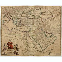
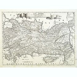
Turcicum Imperium.
Detailed map of the Turkish Empire by Holland's leading mapmaker at the end of the seventeenth century. The cartouche shows an Ottoman administrator or possibly the Sulta...
Place & Date: Amsterdam, 1680
Selling price: $350
Sold in 2016
Nova Persiae Armeniae Natoliae et Arabiae.
East from Cyprus to Iran with numerous place names and ornamental cartouches below. There are vignettes of sailing ships in sea areas and the land divisions of the time a...
Place & Date: Amsterdam, 1680
Selling price: $160
Sold in 2016
Nova Persiae Armeniae Natoliae et Arabiae.
East from Cyprus to Iran with numerous place names and ornamental cartouches below. There are vignettes of sailing ships in sea areas and the land divisions of the time a...
Place & Date: Amsterdam, 1680
Selling price: $250
Sold in 2016
TURCICUM IMPERIUM.
A detailed map of the Turkish Empire by Holland's leading mapmaker at the end of the seventeenth century. The cartouche shows an Ottoman administrator ,or possibly the S...
Place & Date: Amsterdam, 1680
Selling price: $205
Sold in 2019
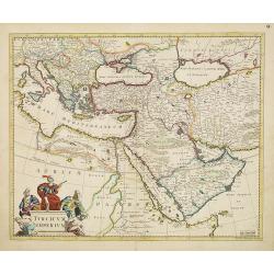
Turcicum Imperium.
Detailed map of the Turkish Empire by Holland's leading mapmaker at the end of the seventeenth century. The cartouche shows an Ottoman administrator or possibly the Sulta...
Place & Date: Amsterdam, 1680
Selling price: $750
Sold in 2011
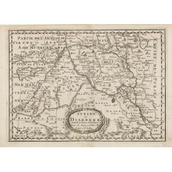
Syrien en Diarbeek verdeelt in hunne Scheidingen.
Engraved map of the Near East, including Cyprus, Palestine, Syria, Iraq, bordered by Greece, Turkey and Iran. The map shows great detail of towns, cities and topography, ...
Place & Date: Utrecht, 1680
Selling price: $70
Sold in 2016
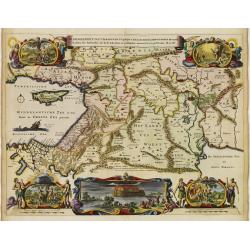
De gelegentheyt van 't Paradys en de 't Landt Canaan..
A finely engraved map of the Middle East from the Mediterranean, including Cyprus, eastwards to Syria and Iraq.At the four corners are insets showing the temptation of Ev...
Place & Date: Amsterdam 1682
Selling price: $200
Sold
De Beschrijvingh van de Reysen Pauli..
Decorative map with 8 insets depicting the wanders of Paulus and the Apostles. Dutch text on verso. Covers the territory from Sicily in the Mediterranean Sea to the Persi...
Place & Date: Amsterdam 1682
Selling price: $200
Sold
Isles de Cypre.
A charming late 17th century French map of Cyprus with a large pictorial cartouche depicting an infantry combat.By Allain Manneson Mallet (1630-1706), a well traveled mil...
Place & Date: Franckfurt 1684
Selling price: $350
Sold
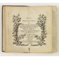
Atlas Terrestris: or a Book of Mapps of all the Empires, Monarchies, Kingdoms, Regions, . . . in the whole World.
One of a series of composite world atlases of varying contents published by John Seller (fl.1658-1698) from 1676 onwards and among one of the very earliest English world ...
Place & Date: London: John Seller, [no date] c. 1684
Selling price: $12000
Sold in 2010
Kurtze Beschreibung von dem Ursprung, Aufnehmen, Gebiete und Regierung der Weltberühmten Republick Venedig.
Short description of the origin, recording, and government areas of the world-famous “Venice Republick.” The first and only edition of this rare work. The copper eng...
Place & Date: Nuremberg, 1686
Selling price: $1601
Sold in 2015

Asiae Minoris lacobi cantelly vineolensis...
Giacomo Rossi's fine late 17th century map of Turkey and Cyprus. Issued in Il Mercurio geografico
Place & Date: Rome, 1686
Selling price: $200
Sold in 2015
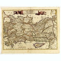
Asiae Minoris lacobi cantelly vineolensis...
Giacomo Rossi's fine late 17th century map of Turkey and Cyprus. Issued in Il Mercurio geografico In upper center a tittle cartouche.The cartographer was Giacomo Cantelli...
Place & Date: Rome, 1686
Selling price: $400
Sold in 2016
De Beschryving van de Reysen Pauli en Van de Andere Apostelen.
The Dutch so-called ' Staten' bibles published between 1637 and c. 1760, contained 5 maps: The World, ' Paradise', The Perigrinations, The Promised Land Canaan, The Trave...
Place & Date: Dordrecht-Amsterdam, H. Keur en M. Doornik, 1686
Selling price: $300
Sold
Die Insel Cypern / Isles de Cypre
Decorative engraved map of Cyprus from Alain Manesson Mallet. With a interesting battle scene.
Place & Date: Frankfurt, 1686
Selling price: $200
Sold in 2009
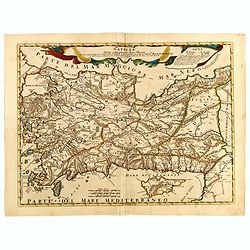
Asia minoris, . . .
Detailed map of Turkey with Cyprus, by Giacomo Cantelli da Vignola (1643-1695). Map Turkey's cities and political divisions as they existed during the Roman Empire.Engrav...
Place & Date: Rome, 1686
Selling price: $225
Sold in 2011
Beschryvinge van den Oorsprong der Volkeren, Uit de drie..
A very decorative map of the region from the Mediterranean through to the Persian Gulf, including Cyprus.The map depicts the Garden of Eden, Abraham's route from Ur, and ...
Place & Date: Amsterdam, 1687
Selling price: $170
Sold
A mapp of the travels and voyages of the apostles..
The engraver of this map was Richard Palmer.Finely engraved detailed map covering the whole of the eastern Mediterranean. Showing the travels of the apostles after the de...
Place & Date: London 1687
Selling price: $445
Sold
De Gelegentheyt van t' Paradys en t' Landt Canaan, mitsgaders d' eerst bewoonde Landen der Patriarchen.
Dutch so-called ' Staten' bibles, published between 1637 and c. 1760, contained 5 maps: The World, ' Paradise', The Perigrinations, The Promised Land Canaan, The Travels ...
Place & Date: Amsterdam, Hendrik Keur en Marcus Doornick, 1688
Selling price: $300
Sold in 2009
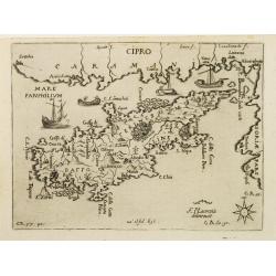
CIPRO
Rare map of the island of Cyprus from Francesco Piacenza's : L'Egeo Redivivo o'sia Chrorographia dell'Arcipelago, e dello stato primiero, & attuale di quell'isole, re...
Place & Date: Modena, 1688
Selling price: $5300
Sold
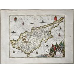
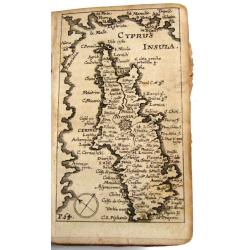
Cyprus Insula
Title in a cartouche with putti and Neptune at bottom right, two coats-of-arms at top corners.From: O. Dapper, Naukeurige Beschrijving der Eilanden in de Archipel der Mid...
Place & Date: Amsterdam, 1688
Natolia detta anticamente Asia minore...
Giacomo Rossi's fine late 17th century map of Ancient Turkey, with Cyprus. Issued in Il Mercurio geografico In upper center title cartouche.
Place & Date: Rome, 1686-1688
Selling price: $200
Sold in 2015
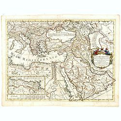
Stato del Gran Turco diviso ne suoi Beglierbati, . . .
Rossi's scarce map of Turkish Empire with the Eastern Mediterranean, Cyprus, Turkey, Arabia, the Black Sea, Asia Minor and neighboring regions.
Place & Date: Rome, 1679-1688
Selling price: $250
Sold in 2015
A Mapp of the Travels and Voyages of the Apostales in Their Mission and in Particular of Saint Paul.
Beautiful Holy Land figural map of the travels of St. Paul and the Apostles by Richard Blome and engraved by Jan Kip. A series of thirteen border vignettes featuring the ...
Place & Date: London, 1689
Selling price: $220
Sold in 2017
Die Legend des tradition Paradiesis und des Landes Canaan. . .
A handsome late seventeenth century map of 'Earthly Paradise', comprising the Holy land and the Middle East. The map extends from modern-day southern Turkey and Cyprus, e...
Place & Date: Amsterdam, ca 1690
Geographiae Sacrae .. Totius Orbis Partes..
Standard map of the ancient world. Centred on Cyprus. With inset map of Egypt.This edition carries the date 1690.Nicolas Sanson was to bring about the rise of French cart...
Place & Date: Paris 1690
Selling price: $160
Sold