Search Listings matching "cyprus"
![[Holy Land, Cyprus]](/uploads/cache/84451-250x250.jpg)
[Holy Land, Cyprus]
Attractive colored woodcut map showing the Holy Land with Cyprus. With a ship and a sea monster. From a Latin edition of Cosmographia by Sebastian Munster.
Place & Date: Petri, Basle, 1550 ca.
Selling price: $175
Sold in 2020
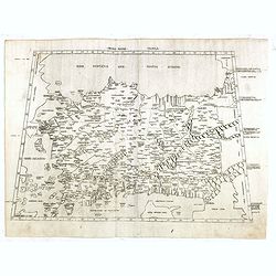
Prima Asiae Tabula.
Copperplate printed map of Turkey and including Cyprus from the "Atlas In Hoc Operae Haec Continetur…" printed by Bernardinus Venetus de Vitalibus. The map sh...
Place & Date: Rome, 1478 or 1490
Selling price: $3500
Sold
![[Incunable] (Rudimentum novitiorum: French:) La mer des histoires.](/uploads/cache/22865-250x250.jpg)
[Incunable] (Rudimentum novitiorum: French:) La mer des histoires.
One of the rarest of French illustrated incunables. The Mer des histoires (?A sea of stories?) is the French adaptation of the Latin Rudimentum novitiorum, an abridged h...
Place & Date: Lyon: Jean Du Pré, 20-23 August 1491
Selling price: $37100
Sold
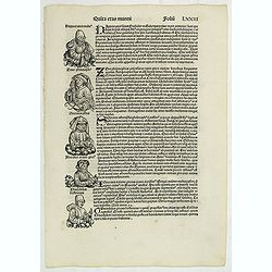
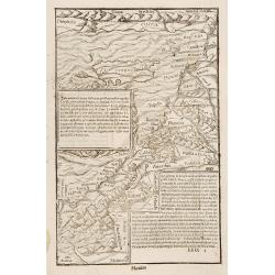
Quita Etas Mundi. Folium.LXXIII
The Latin text page is illustrated with a depictions of Kings, Noble men and women and scientists. RECTO : Including a portrait of Zeno, an Attic philosopher from Cyprus....
Place & Date: Nuremberg, 12 July 1493
Selling price: $50
Sold in 2019
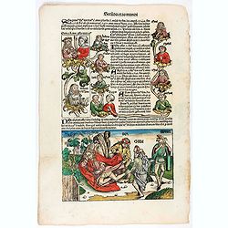
Secunda Etas Mundi. Foliu XV
The Latin text page is illustrated with a depictions of Kings, Noble men and women and scientists. RECTO : Including a portrait of Zeno, an Attic philosopher from Cyprus....
Place & Date: Nuremberg, 12 July 1493
Selling price: $250
Sold in 2020
Quita Etas Mundi. Folium.LXXIII
The Latin text page is illustrated with a depictions of Kings, Noble men and women and scientists. RECTO : Including a portrait of Zeno, an Attic philosopher from Cyprus....
Place & Date: Nuremberg, 12 July 1493
Selling price: $68
Sold in 2022
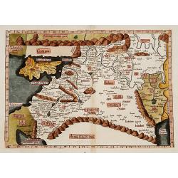
Tabula Quarta Asia (Holy Land and Cyprus)
One of the earliest maps available to a collector of Cyprus, Syria, Mesopotamia,. Babylonia, Arabia Petraea, Armenia Minor and the Holy Land, based upon the Georgraphy of...
Place & Date: Strasburg, 1525
Selling price: $2000
Sold in 2015
![Tabula IIII Asiae. [Holy Land, Syria, Cyprus, Arabia.]](/uploads/cache/26877-250x250.jpg)
Tabula IIII Asiae. [Holy Land, Syria, Cyprus, Arabia.]
One of the earliest maps available to a collector of Cyprus, Syria, Mesopotamia,. Babylonia, Arabia Petraea, Armenia Minor and the Holy Land, based upon the Georgraphy of...
Place & Date: Strassburg, 1535
Selling price: $1550
Sold in 2011
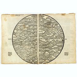
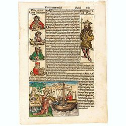
World (La Mer des histoires).
The World map was, in its basis and design mediaeval, with the World compressed into the circular frame of the 'T-O' form. The world is portrayed in pictorial form thus, ...
Place & Date: Dupre, Paris, 1536
Selling price: $6100
Sold in 2016
Cyria / Cypern / Palestina / Mesopotamia / Babylonia / Chaldea und zwey Arabia mit Bergen Wassern und Stetten.
An early, attractive woodcut map of the eastern Mediterranean and the Middle East. Covering the area between northern Syria and the Red Sea, with Cyprus, the Holy Land, J...
Place & Date: Basel, ca 1540
Selling price: $190
Sold in 2021
-250x250.JPG)
Cyprus, L'Isle de Cypre
Antique woodcut map of Cyprus by Sebastian Münster, [In letter-text above the map:] L'isle de Cypre.Probably the oldest obtainable map showing Cyprus only.On the back...
Place & Date: BASEL, ca 1550
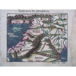
Cyprus/Near East, & text on Cyprus. - Syrie avec les prouinces
Antique woodcut map of Cyprus + the Near East by Sebastian Münster, [In letter-text above the map:] Syrie avec les prouinces. Together one more text sheet on Cyprus ['...
Place & Date: BASEL, ca 1550
![Von den Laendern Asie [Palestine]](/uploads/cache/18623-250x250.jpg)
Von den Laendern Asie [Palestine]
Sebastian Münster, 1489-1552, outstanding geographer of Basle. Editied Ptolemy's atlas ' Geographia Universalis', editions 1540,-42, -45, -51 and -52. Published his &quo...
Place & Date: Basle, 1550
Selling price: $200
Sold
![[Lot of 2 plates] Ierusalem civitas../ [map of Palestine + Cyprus].](/uploads/cache/48240-250x250.jpg)
[Lot of 2 plates] Ierusalem civitas../ [map of Palestine + Cyprus].
Early woodcut view of the city of Jerusalem surrounded by its ancient walls, featuring the temples and mosques. From the 1552 Latin text edition of Munster's Cosmographia...
Place & Date: Basel, 1552
Selling price: $100
Sold in 2023
![[Lot of 2 leaves with map of Cyprus]](/uploads/cache/48277-250x250.jpg)
[Lot of 2 leaves with map of Cyprus]
Two printed text leaves relating to Cyprus with a map (10 x 15 cm). From the 1552 Latin text edition of Münster's Cosmographia, which is a short and complete summary of ...
Place & Date: Basel, 1552
Selling price: $58
Sold in 2022
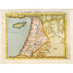
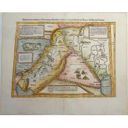
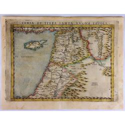
Soria et Terra Santa nova tavola.
Uncommon first edition of this classical map of the Holy Land, including Cyprus. The map is an enlarged version of Giacomo Gastaldi's published in 1548Girolamo Ruscelli's...
Place & Date: Venice, 1561
Selling price: $400
Sold in 2016
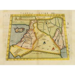
Tabula Asiae IIII.
Uncommon first edition of this classical map of the Holy Land, including Cyprus. The map is an enlarged version of Giacomo Gastaldi's published in 1548Girolamo Ruscelli's...
Place & Date: Venice, 1561
Selling price: $700
Sold in 2011
![Sinus Persicus [Arabia]](/uploads/cache/39586-250x250.jpg)
Sinus Persicus [Arabia]
Rare wood block printed map of the Holy Land, Syria, Cyprus, northern Arabia from "De orbis situ libri tres accuratissime emendati". Underneath the map a letter...
Place & Date: Basle, Henri Petri, 1564
Selling price: $150
Sold in 2017
![[untitled map of Spain and Portugal] Al Molto Mag et Ecc Alessandro Serego, Che lo studio della Geografia..](/uploads/cache/25016-250x250.jpg)
[untitled map of Spain and Portugal] Al Molto Mag et Ecc Alessandro Serego, Che lo studio della Geografia..
A rare map of Spain and Portugal, with an oversized Majorca. One of the first printed maps of Cyprus. A unique opportunity to acquire a fine example of a map from the ear...
Place & Date: Venice, 1566
Selling price: $9000
Sold in 2010
![[Tevarya] Lago di Tiberia.](/uploads/cache/16894-250x250.jpg)
[Tevarya] Lago di Tiberia.
Extremely rare map centered on the town and Lake Tevarya, including Jerusalem, Bethlehem, Sichem, Damascus and the island of Cyprus.Engraved by Paolo Furlani (active 1561...
Place & Date: Venice 1568
Selling price: $1925
Sold
![[Tevarya] Lago di Tiberia.](/uploads/cache/22050-250x250.jpg)
[Tevarya] Lago di Tiberia.
Extremely rare map centered on the town and Lake Tevarya, including Jerusalem, Bethlehem, Sichem, Damascus and the island of Cyprus.Engraved by Paolo Furlani (active 1561...
Place & Date: Venice 1568
Selling price: $1750
Sold
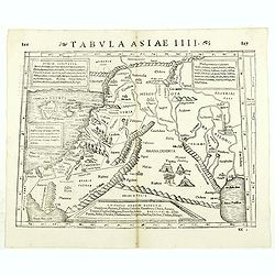
Tabula Asiae IIII. ( Holy Land, Cyprus, Syria, etc.)
Double-page woodcut Ptolemaic-style map by Sebastian Münster figuring Holy Land, Cyprus, Syria, etc., published in the edition of Strabo by Henri Petri in 1571."Str...
Place & Date: Basle, Henri Petri, 1571
Selling price: $75
Sold in 2018
![[Cyprus].](/uploads/cache/41984-250x250.jpg)
[Cyprus].
Woodcut Ptolemaic-style map by Sebastian Münster figuring Cyprus, published in the edition of Strabo by Henri Petri in 1571."Strabonis rerum geographicarum" is...
Place & Date: Basle, Henri Petri, 1571
Selling price: $180
Sold in 2018
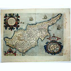
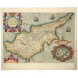
Cypri insulae nova descript.
A milestone in the history of cartography of Cyprus, based on a 1570 map by Giacomo Franco. The map is embellished by sailing ships and a sea monster, bearing a map of Le...
Place & Date: Antwerp, 1573
Selling price: $1200
Sold in 2020
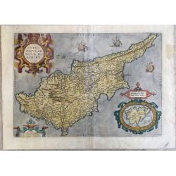
Cypri Insulae Nova descript. 1573.
This is a beautiful copy of a classic map of Cyprus. It is the earliest obtainable version of the best map of Cyprus made to date. Ortelius based his map upon that publis...
Place & Date: Antwerp, 1574
Selling price: $2700
Sold in 2011
![[Asia Minor]](/uploads/cache/35967-250x250.jpg)
[Asia Minor]
Early, attractive hand-colored woodcut map of Turkey, with an unnamed Cyprus in the lower right corner. From the German edition of Sebastian Münster's Cosmography, title...
Place & Date: Basle, ca. 1574
Selling price: $140
Sold in 2016
Soria et Terra Santa Nuova Tavola.
Ruscelli's map of the Holy Land, Syria and Cyprus. One of the earliest obtainable separately published maps of the region. The map first appeared in the 1561 edition of R...
Place & Date: Venice, 1574
Selling price: $290
Sold in 2017
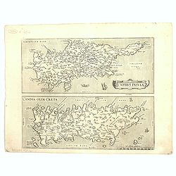
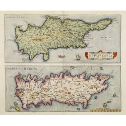
Cyprus Insula / Candia, Olim Creta.
Two maps on one sheet. Copper engraving illustrating Cyprus and Crete, with Latin text on verso. From 1584 onwards editions of the Ortelius atlas no longer included this ...
Place & Date: Antwerp, 1575
![Calaris [on sheet with] Malta [and] Rhodus [and] Famagusta.](/uploads/cache/33682-250x250.jpg)
Calaris [on sheet with] Malta [and] Rhodus [and] Famagusta.
One sheet with very desirable and early town-plans of four Mediterranean island capitals—Cagliari (Sardinia), Valletta (Malta), Rhodes, and Famagusta (Cyprus). "C...
Place & Date: Cologne, (1572) 1577
Selling price: $550
Sold in 2015
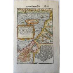
Holy Land. Die Tafel gibt ein klein anzeigung...
Early, attractive woodcut map of the Holy Land with Cyprus. On the full page. From the German edition of Sebastian Münster's Cosmography, titled Cosmographey oder beschr...
Place & Date: Basel, 1578
Selling price: $150
Sold in 2020
No title (Holy Land)
Attractive full page longitudinal map of Palestine, Syria and Cyprus, cut by Hans Rudolf Manuel Deutsch. The shore line running from Southern Anatolia to the Nile Delta. ...
Place & Date: Basle 1550-1580
Selling price: $220
Sold
![[Cyprus]](/uploads/cache/26211-250x250.jpg)
[Cyprus]
Two woodcuts on one page. In upper part a map of Cyprus, in lower part a jumping deer and a sheep drinking water. The drinking sheep with old pen scratches. From his Cosm...
Place & Date: Basle, 1550-1580
Selling price: $185
Sold in 2008
![[Map of the Holy Land, including Cyprus]](/uploads/cache/26213-250x250.jpg)
[Map of the Holy Land, including Cyprus]
Attractive full page longitudinal map of Palestine, Syria and Cyprus, cut by Hans Rudolf Manuel Deutsch. The shore line running from Southern Anatolia to the Nile Delta. ...
Place & Date: Basle 1550-1580
Selling price: $70
Sold in 2008
![[Cyprus]](/uploads/cache/92347-250x250.jpg)
[Cyprus]
Very early map of Cyprus, by Sebastian Münster from his Cosmographia. On a full sheet with text on both sides in German, and a print of deer.
Place & Date: Basel, 1550-1580
Selling price: $80
Sold in 2013
Cypri Insulae Nova descript. 1573.
This is a beautiful copy of a classic map of Cyprus. It is the earliest obtainable version of the best map of Cyprus made to date. Ortelius based his map upon that publis...
Place & Date: Antwerp, 1581
Selling price: $800
Sold in 2014
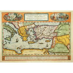
Peregrinatio Divi Pauli Typus Corographicus.
"A splendid map depicting the travels of Paulus. With two fine scenes in top. Showing the countries along the Mediterranean, including Cyprus and Italy. A first edit...
Place & Date: Antwerp 1584
Selling price: $850
Sold
Cyprus Insula / Candia, Olim Creta.
Two maps on one sheet. Copper engraving illustrating Cyprus and Crete, with Latin text on verso. From 1584 onwards editions of the Ortelius atlas no longer included this ...
Place & Date: Antwerp, 1570-1584
Selling price: $1800
Sold in 2008
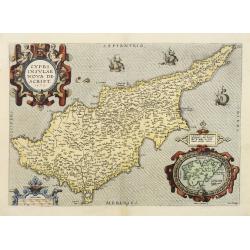
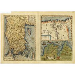
CYPRI INSULAE NOVA DE SCRIPT 1573 - LEMNOS INSULAE.
A striking, old colored example of this important early map of Cyprus from Ortelius' Theatrum Orbis Terrarum, the first modern atlas of the world. Large inset of Lemnos. ...
Place & Date: Antwerp, 1584
Selling price: $700
Sold in 2019
Tafel Der Lender Darin Der Apostel Paulus Geprediget Hat.
The Eastern Mediterranean, from the "Itinerarium Sacrae Scripturae", showing Italy, Sicily, Greece, Cyprus, Asia Minor, the Holy Land and North Africa, with cit...
Place & Date: Magdeburg, 1585
Selling price: $400
Sold in 2014
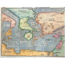
Natoliae Quae Olim Asia Minor, Nova de Scriptio / Carthaginis Celeberrimi Sinus Typus / Aegypti re Centior de Scriptio
Three detailed regional maps by Ortelius, from his Theatrum Orbis Terrarum, the first modern atlas of the world.The first map covers Asia Minor, Cyprus and the Eastern Me...
Place & Date: Antwerp, 1587
Selling price: $210
Sold in 2012