Browse Listings
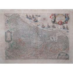
Novus XVII Inferioris Germania Provinciarum Typus.
This is undoubtedly one of the most magnificent maps of the seventeen provinces of the Netherlands. It was first produced as a separately issued wall map in 1608 with fig...
Date: Amsterdam, 1645
Selling price: ????
Please login to see price!
Sold in 2010
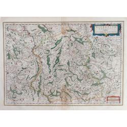
Nivernium Ducatus Gallice Duche de Nevers.
Blaeu map of central France showing, on the east side, the city of Bourges, and to the west, the city of Autun.
Date: Amsterdam, 1645
Selling price: ????
Please login to see price!
Sold in 2010
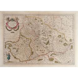
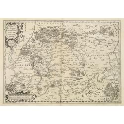
Comitatus Bellovacum Vernacule Beauvais.
Bleau map of northern central France region, showing area just north of Paris.
Date: Amsterdam, 1645
Selling price: ????
Please login to see price!
Sold in 2010

Nivernum Ducatus Gallice duche de Nevers
Map of the Nevers region in central France from Johan Blaeu's Nievwe Atlas. The city of Bourges is depicted on the left edge of the map, and the city of Auton on the righ...
Date: Amsterdam, 1645
Selling price: ????
Please login to see price!
Sold in 2010
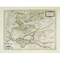
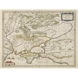
Taurica Chersonesus, Nostra aetate Przecopsca, et Gazara dicitur.
Part of Russia with in the north Smolensk and including Moscow and in the south the Black Sea.More about Willem Blaeu. [+]Taurica, Tauric Chersonese, and Taurida were nam...
Date: Amsterdam, 1645
Selling price: ????
Please login to see price!
Sold in 2011
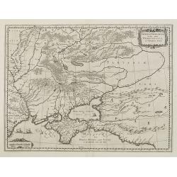
Taurica Chersonesus, Nostra aetate Przecopsca, et Gazara dicitur.
Detailed map of the Ukraine, Russia with in the north Smolensk and Moscow and in the south the Black Sea. Shows ports, fortified cities and the mouths of the Danube. With...
Date: Amsterdam, 1645
Selling price: ????
Please login to see price!
Sold in 2016
L'isle de France. Parisiensis Agri descriptio.
Map of Ile d'France with Paris, the river Seine and the town north of Paris, showing Pontoise, Meaux, Senlis, Meudon.The map was prepared by François de la Guillotière,...
Date: Amsterdam, 1645
Selling price: ????
Please login to see price!
Sold
Taurica Chersonesus, Nostra aetate Przecopsca, et Gazara dicitur.
Part of Russia with in the north Smolensk and including Moscow and in the south the Black Sea.
Date: Amsterdam, 1645
Selling price: ????
Please login to see price!
Sold in 2010
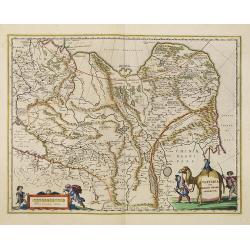
Tartaria sive Magni Chami imperium.
Detailed and decorative map of Tartary [i.e. Mongolia and Siberia] which is annotated with the major cities and towns of the region. Chinae Regni Pars [i.e. China] is sho...
Date: Amsterdam, 1645
Selling price: ????
Please login to see price!
Sold in 2010
Danubius Fluvius Europae Maximus, a Fontibus ad Ostia. . .
Depicts the course of the Danube River, from its sources in the Alps to the Black Sea..Because of the dimensions the map was printed from two copper plates.With two very ...
Date: Amsterdam, 1645
Selling price: ????
Please login to see price!
Sold in 2010
Tartaria sive Magni Chami Imperium.
Detailed and decorative map of Tartary and Northern part of China. Northern tip of Korea included. The Chinese Great Wall is depicted, with Central Asia, extending from M...
Date: Amsterdam, 1645
Selling price: ????
Please login to see price!
Sold in 2010
Danubius Fluvius Europae Maximus, a Fontibus ad Ostia. . .
Depicts the course of the Danube River, from its sources in the Alps to the Black Sea..Because of the dimensions the map was printed from two copper plates.With two very ...
Date: Amsterdam, 1645
Selling price: ????
Please login to see price!
Sold in 2013
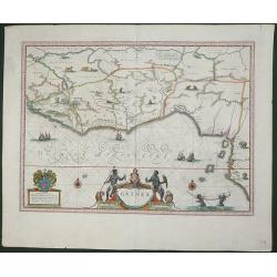
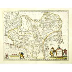
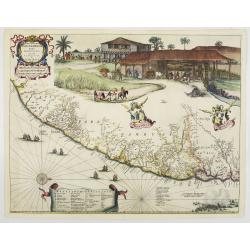
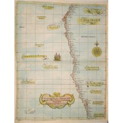
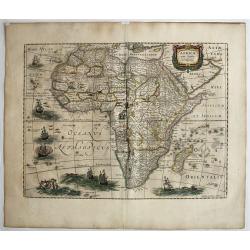
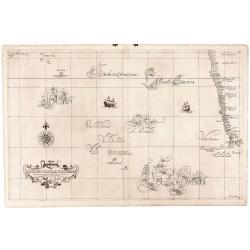
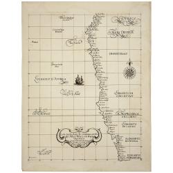
Guinea.
An attractive map covering the coast from Sierra Leone to Gabon, filled with intersecting rhumb lines and decorated with monkeys, lions, elephants, sea monsters, and two ...
Date: Amsterdam, c.1645
Selling price: ????
Please login to see price!
Sold in 2012
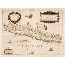
Chili.
Willem Blaeu's very decorative map of Chile with two large and beautiful cartouches, a compass and ships.
Date: Amsterdam 1646
Selling price: ????
Please login to see price!
Sold
Chili.
Very decorative map of Chilli with two large and beautiful cartouches, a compass and ships.
Date: Amsterdam 1646
Selling price: ????
Please login to see price!
Sold
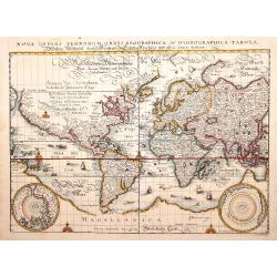
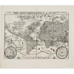
Nova totius terrarum orbis geographica ac hydrographica..
A reduced version of Blaeu's world map lacking the decorative borders. The engraving is neatly executed, with Germanic touches to the lettering, and the Latin title is re...
Date: Frankfurt 1646
Selling price: ????
Please login to see price!
Sold
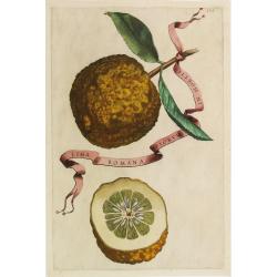
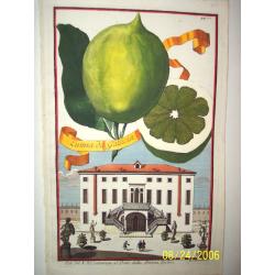
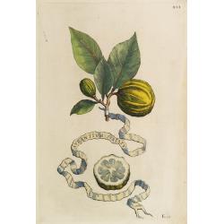
Lima Romana Piorum In Hortis.
Decorative engraving representing a citrus fruit. Taken from the book "Hesperides sive de malorum aureorum" by Giovan Battista Ferrari (Italian botanist, 1584-1...
Date: Rome, Scheus, 1646
Selling price: ????
Please login to see price!
Sold
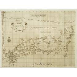
Asia carta di ciasete piu moderna. (Japan)
Rare Japan map of the Blancus/Moreira type. The place names follow Ginnaro, though he invented numerous additional imaginative names. From the first edition of hisDell'Ar...
Date: Florence 1646
Selling price: ????
Please login to see price!
Sold
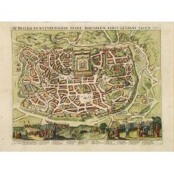
De heylige en wytvermaerde stadt Jerusalem.
Imaginary plan of ancient Jerusalem with all the principal sites numbered and keyed to a table at bottom. Shows the city with the Second Temple and Herrod's Castle and th...
Date: Amsterdam 1646
Selling price: ????
Please login to see price!
Sold
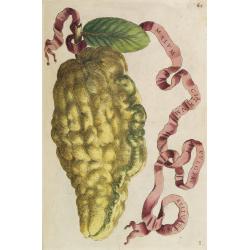
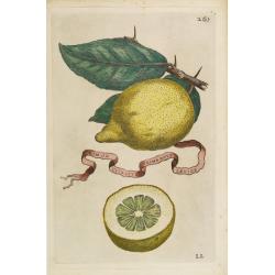
Lumia da Gallicia.
Johann Christopher Volckhamer was a wealthy Germany merchant with an orangerie where he grew exotic citrus fruits. His resources enabled him to engage a talented team of...
Date: Rome, ca. 1646
Selling price: ????
Please login to see price!
Sold
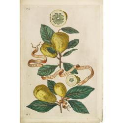
Malum Citreum Vulgare Belluatum.
Decorative engraving representing a citrus fruit. Taken from the book "Hesperides sive de malorum aureorum" by Giovan Battista Ferrari (Italian botanist, 1584-1...
Date: Rome, Scheus, 1646
Selling price: ????
Please login to see price!
Sold in 2009
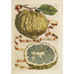
Aurantium Striatum.
Decorative engraving representing a citrus fruit. Taken from the book "Hesperides sive de malorum aureorum" by Giovan Battista Ferrari (Italian botanist, 1584-1...
Date: Rome, Scheus, 1646
Selling price: ????
Please login to see price!
Sold
Limon Citratus Primae Notae Laevior.
Decorative engraving representing a citrus fruit. Taken from the book "Hesperides sive de malorum aureorum" by Giovan Battista Ferrari (Italian botanist, 1584-1...
Date: Rome, Scheus, 1646
Selling price: ????
Please login to see price!
Sold
Peretta Sive Spatafora Duplex.
Decorative engraving representing a citrus fruit. Taken from the book "Hesperides sive de malorum aureorum" by Giovan Battista Ferrari (Italian botanist, 1584-1...
Date: Rome, Scheus, 1646
Selling price: ????
Please login to see price!
Sold
Lima Eadem Rotunda.
Decorative engraving representing a citrus fruit. Taken from the book "Hesperides sive de malorum aureorum" by Giovan Battista Ferrari (Italian botanist, 1584-1...
Date: Rome, Scheus, 1646
Selling price: ????
Please login to see price!
Sold
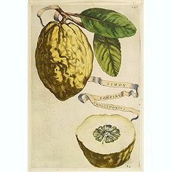
Limon ponzinus chalcedonius.
Decorative engraving representing a citrus fruit. Taken from the book "Hesperides sive de malorum aureorum" by Giovan Battista Ferrari (Italian botanist, 1584-1...
Date: Rome, Scheus, 1646
Selling price: ????
Please login to see price!
Sold
![[Title page] Topographia Sueviae..](/uploads/cache/11848-250x250.jpg)
[Title page] Topographia Sueviae..
Very fine title page by one of Germany most important publishers.
Date: Frankfurt, 1646
Selling price: ????
Please login to see price!
Sold in 2008
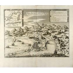
Abbildung der Statt Gigeri in affrica, wie solche der König in Franckreich durch den Hertzogen de Beaufort eingenohmen
Attractive engraving of the Jijel (Djidjelli) in North-west Algeria from Matthaus Merian. Showing the city with several ships and the Atlas Mountains in background. With ...
Date: Frankfurt, 1646
Selling price: ????
Please login to see price!
Sold in 2009
Goa
Beautiful birdeye view of Goa in India from Matthaus Merian. Showing the city at the beginning of the 17th century with many ships in the harbour and a cartouche describi...
Date: Frankfurt, 1646
Selling price: ????
Please login to see price!
Sold in 2009
Carta particolare che comincia con il capo di Oringan in Biscaia è Finisce con la costa di Alcason In Francia . . . di Europa Carta XXIII.
First state of Dudley's magnificent chart showing the Bay of Biscay. Include sailing ships, compass card, notes on prevailing winds and currents and more stylized calligr...
Date: Florence, 1646
Selling price: ????
Please login to see price!
Sold in 2009
Carta Particolare che commincia con il capo Aldea è Finisce?
Engraved by Lucini.Sir Robert Dudley's Dell'Arcano del Mare is the earliest printed sea atlas to cover the entire world, and the first made by an Englishman, and the firs...
Date: Florence 1646
Selling price: ????
Please login to see price!
Sold in 2010
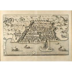
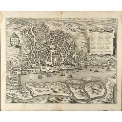
Algier
Attractive birdeye view of Algiers in Algeria from Matthäus Merian. Showing the city with city walls, outlying forts and several ships in the harbour. From J. Gottfried'...
Date: Frankfurt, 1646
Selling price: ????
Please login to see price!
Sold in 2009
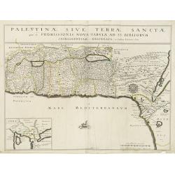
Palestinae sive Terrae Sanctae quae et Promissionis Nova Tabula ad SS. Bibliorum Intelligentiam Delineata ex Christiano Adrichomio collecta
A uncommon map of the Holy Land, based on Christian von Adrichem's two-sheet map of 1590. This map shows the shoreline from Sidon to Alexandria, and includes the mouth of...
Date: Paris, 1646
Selling price: ????
Please login to see price!
Sold in 2010
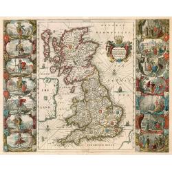
BRITTANNIA prout divisa fuit temporibus Anglo-Saxonum, ...
Decorative "carte à figures" map by Blaeu of the United Kingdom.
Date: Amsterdam, 1646
Selling price: ????
Please login to see price!
Sold in 2009
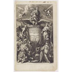
Io. Petri Lotichii Rerum Germanicarum Libri. LV Francofurti Ad Moenum.
Beautiful allegorical engraved frontispiece. Various classical figures represent the war.
Date: Frankfurt, 1646
Selling price: ????
Please login to see price!
Sold in 2018
Africae nova Tabula.
Fine map of Africa, it's the issue of Jodocus Hondius map, without the decorative borders. There are six ships in full sail on the Atlantic and one to the south of Madaga...
Date: Amsterdam, 1646
Selling price: ????
Please login to see price!
Sold in 2017
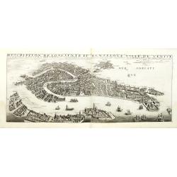
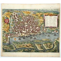
Description de lopulente et manifique ville de Venise.
Extremely rare panoramic town-view of Venice and neighboring islands (Murano, Burano, Torcello and Mazorbo), clearly depicting the city's architectural landmark. The surr...
Date: France, 1646
Selling price: ????
Please login to see price!
Sold in 2012
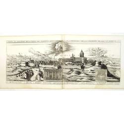
Profil et elevation de la ville de Lorette avec le transport de la chambre de la Ste. Vierge.
Extremely rare panoramic town-view of Loreto, near Ancona in Italy, clearly depicting the city's architectural landmark. Published by Jean Boisseau (fl.1637-1658) a Frenc...
Date: France, 1646
Selling price: ????
Please login to see price!
Sold in 2010
GOA.
This southern oriented map depicts the Portuguese colony of Goa, which is situated on the west coast of India and was a key port of trade for merchants. The map is very d...
Date: Frankfurt, ca. 1646
Selling price: ????
Please login to see price!
Sold in 2020
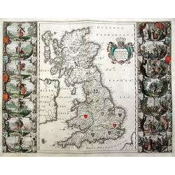
Britannia prout divisa fuit temporibus Anglo-Saxonum, presertim durante illorum Heptarchia.
An important and sought-after double-page map, decorated with the shields of the Saxon kingdoms, and 14 superb scenes of Anglo-Saxon history in full color. Finely engrave...
Date: Amsterdam, ca. 1646
Selling price: ????
Please login to see price!
Sold in 2019
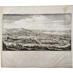
TUNIS.
A beautiful, antique town view of Tunisia, Tunis. Printed in Frankfurt by Merian in 1646. Including zoological and botanical gardens. From J. Gottfried's "Neuwe Arch...
Date: Frankfurt, 1646
Selling price: ????
Please login to see price!
Sold in 2021
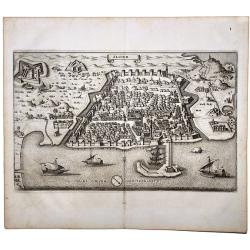
ALGIER.
A beautiful, antique town view of Algiers, printed in Frankfurt by Merian in 1646. An attractive birds-eye view of Algiers in Algeria showing the city with its walls, out...
Date: Frankfurt, 1646
Selling price: ????
Please login to see price!
Sold in 2020
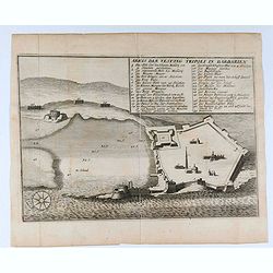
Abris der Vestung Tripoli in Barbarien.
Interesting engraving of the fort of Tripoli in Libya from Matthäus Merian. Showing details of the fort with an 29 key indexMatthäus Merian the Elder was born September...
Date: Frankfurt, 1646
Selling price: ????
Please login to see price!
Sold in 2020
![Monachium. München. [Munich]](/uploads/cache/84272-250x250.jpg)
Monachium. München. [Munich]
City map of the city of Munich with the bavarian and the munich coats of arms, a windrose and an index.Munich-Munchen, the name of the city is derived from the Old/Middle...
Date: Frankfurt, ca. 1646
Selling price: ????
Please login to see price!
Sold in 2020
![Geneue. Genff. [Geneva]](/uploads/cache/84276-250x250.jpg)
Geneue. Genff. [Geneva]
This is a detailed panorama of Geneva, looking towards the lake.Matthäus Merian sr. (the elder; 1593-1630) was born in Switzerland but eventually settled in Frankfurt; h...
Date: Frankfurt, ca. 1646
Selling price: ????
Please login to see price!
Sold in 2021
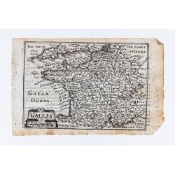
Gallia.
Miniature map of France. Text on verso.
Date: London, William Humble, 1646
Selling price: ????
Please login to see price!
Sold in 2020
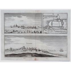
Cales. // Calais. // Duynkerke.
Fine unusual 1646 Merian copper engraved plate including a panoramic view of Calais, France, aerial plan of Calais, with its fortifications and the surrounding area, &a...
Date: Zurich, 1646
Selling price: ????
Please login to see price!
Sold in 2023
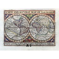
A New and Accurat Map of the World drawne according to ye truest Descriptions latest Discoveries.
A superb miniature map of the world in two hemispheres. With curious coast lines and a huge southern continent. Incomplete North America. Australia appears to be joined t...
Date: Amsterdam, ca 1646
Selling price: ????
Please login to see price!
Sold in 2020
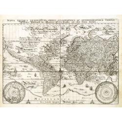
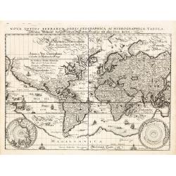
Nova Totius Terrarum Orbis Geographica ac Hydrographica Tabula.
A very decorative world map presented on Mercator’s projection with cartography closely copied from Blaeu’s world map of 1606, second state, without Merian’s name o...
Date: Frankfurt, 1646
Selling price: ????
Please login to see price!
Sold in 2022
Carta particolare del Oceano che comincia con il capo S. Vincentio...
A fine example of Sir Robert Dudley's nautical chart of Portugal that encompass the coast from Lisbon south to Lagos. The map was part of Dell' Arcano Del Mare (Mysteries...
Date: Florence, 1646
Selling price: ????
Please login to see price!
Sold in 2023
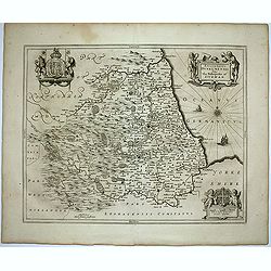
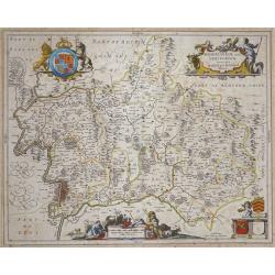
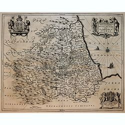
Episcopatus Dunelmensis. Vulgo The Bishoprike of Durham.
Fine double-page map of the bishopric and university city of Durham with two title and scale cartouches, and two impressive coat of arms upper left and right corners. Fre...
Date: Amsterdam, 1646
Selling price: ????
Please login to see price!
Sold in 2020
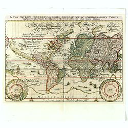
Nova totius terrarum orbis geographica ac hydrographica..
A reduced version of Blaeu's world map lacking the decorative borders. The engraving is neatly executed, with Germanic touches to the lettering, and the Latin title is re...
Date: Frankfurt, 1646
Selling price: ????
Please login to see price!
Sold in 2013
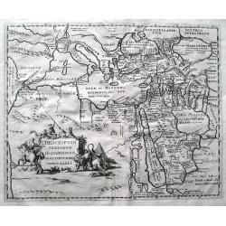
Descriptio terrarum in quasdispersi sunt structores turris Babel.
SCARCE early map of the Mediterranean, the Middle East, and northern Africa. Many areas and coast lines distorted! The Near East is highly detailed with numerous ancient ...
Date: Amsterdam, after1646
Selling price: ????
Please login to see price!
Sold in 2015
Nova totius terrarum orbis geographica ac hydrographica..
A reduced version of Blaeu's world map lacking the decorative borders. The engraving is neatly executed, with Germanic touches to the lettering, and the Latin title is re...
Date: Frankfurt, 1646
Selling price: ????
Please login to see price!
Sold in 2014
Middlesexiae cum Hertfordiae Comitatu: Midlesex & Hertfordshire.
Published in Novus Atlas sive Theatrum orbis Terrarum.The map has Decorative title and scale cartouches with peasants and livestock, upper right and lower centre respecti...
Date: Amsterdam, 1646
Selling price: ????
Please login to see price!
Sold
Nova totius terrarum orbis geographica ac hydrographica tabula. . .
A reduced version of Blaeu's world map lacking the decorative borders. The engraving is neatly executed, with Germanic touches to the lettering, and the Latin title is re...
Date: Frankfurt, 1646
Selling price: ????
Please login to see price!
Sold in 2020
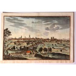
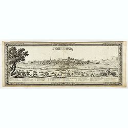
Montpelier.
Fine copper engraving, a bird’s eye view edited by Matthaus Merian, in 1646, in his "Neue Archontologia Cosmica". Matthäus Merian der Ältere (1593–165...
Date: Frankfurt, 1646
Selling price: ????
Please login to see price!
Sold in 2017
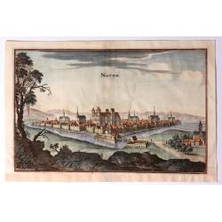
Noyon.
Fine copper engraving, a bird’s eye view, edited by Merian Matthäus, in 1646, in his "Neue Archontologia Cosmica". Matthäus Merian der Ältere (1593–1...
Date: Frankfurt, 1646
Selling price: ????
Please login to see price!
Sold in 2019
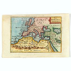
The Romane Empire.
Miniature map of the Roman Empire. The Roman Empire, at its height (c. 117 CE), was the most extensive political and social structure in western civilization.Kaerius (cir...
Date: London, 1646
Selling price: ????
Please login to see price!
Sold in 2016
Episcopatus Dunelmensis. Vulgo The Bishoprike of Durham.
Exquisite black and white map of Durham with two fine title and scale cartouches, and two impressive coat of arms upper left and right corners.
Date: Amsterdam, 1646
Selling price: ????
Please login to see price!
Sold in 2019
Carta particolare che mostra il Capo buona Speranza.
A particularly rich example of the Dudley sea chart with several lush samples of Lucini’s remarkable engraving of calligraphic lettering. The chart, in addition to the ...
Date: Florence, 1646
Selling price: ????
Please login to see price!
Sold in 2018
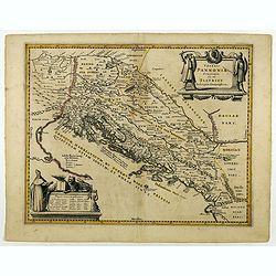
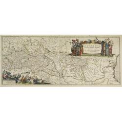
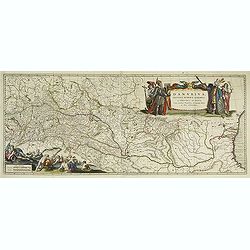
Veteris Pannoniae Utriusque Nec non Illyrici...
Uncommon map of Adriatic Sea. Decorated with two large scale cartouches, one showing two swordsman at odds with one another and the other a royal figure holding a scepter...
Date: Amsterdam, 1646
Selling price: ????
Please login to see price!
Sold in 2018

Den Grooten Figuer-Bibel. Dat is een afbeeldingh en levendighe vertooningh, van alle de voornaemste historien, leeringen en ghelijckenissen der gantscher Heyliger Schrift, in schoone copere figueren by malkander vergadert en in order ghestelt. . .
This fine Dutch Print Bible includes a total of 502 pages with copper engraved prints ; including five engraved titles, 3 folding maps (the Middle East, the Persian Gulf,...
Date: Alkmaar, Simon Cornelisz, 1646
Selling price: ????
Please login to see price!
Sold in 2018
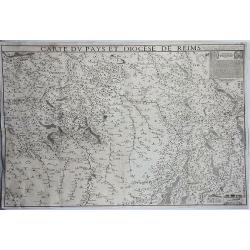
Carte du Pays et Diocese de Reims.
A rare and detailed, very large, copper engraved map of Île-de-France region, France. The map shows the diocese of Reims in the area between Luxembourg in the east, Vitr...
Date: Paris, 1646
Selling price: ????
Please login to see price!
Sold in 2019
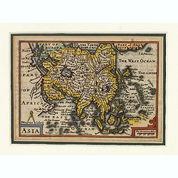
Asia.
This lovely miniature map of the continent of Asia is a single page with text on verso taken from John Speed's folio atlas, and is signed with Van den Keere's Latinized n...
Date: London, 1646
Selling price: ????
Please login to see price!
Sold in 2020
Carta particolare che mostra il Capo buona Speranza con il mare....
The rare first state in a beautiful example.
Date: Florence, 1646
Selling price: ????
Please login to see price!
Sold
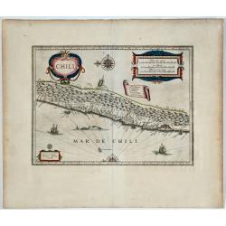
Chili. 

Willem Blaeu's very decorative map of Chile with two large and beautiful cartouches, a compass and ships.
Date: Amsterdam, 1646
Selling price: ????
Please login to see price!
Sold in 2019
Perpignan Capitale de Roussillon.
Panoramic view of Perpignan etched by Romeijn de Hooghe and published by Sebastien de Pontault de Beaulieu (1612-1674). The outer border is printed from a different plate...
Date: Paris, 1646
Selling price: ????
Please login to see price!
Sold in 2020
Magni Mogolis Imperium.
An attractive map of northern India and Central Asia bounded by Pakistan, Afghanistan and Bangladesh and extending inland up the Ganges and Indus Rivers to Tartary and th...
Date: Amsterdam, 1647
Selling price: ????
Please login to see price!
Sold in 2012
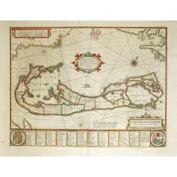
Mappa Aestivarum Insularum, alias Barmudas Dictarum.
A striking map based on the famous survey by Richard Norwood of the Bermuda Company, also known as the Somers Isles Company in 1618. The map shows the division into the o...
Date: Amsterdam, ca.1647
Selling price: ????
Please login to see price!
Sold in 2014
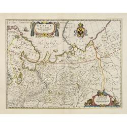
Russiae vulgo Moscovia dictae, Partes Septentrionalis. . .
In the north the Murmansk Sea. Including the western coast of Nova Zembla. Title cartouche and two cartouches, the bottom right one showing two hunters, bears, stags etc....
Date: Amsterdam, 1647
Selling price: ????
Please login to see price!
Sold in 2013
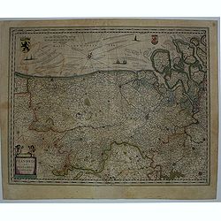
Flandria et Zeelandia Comitatus.
Includes Flanders and Zeeland. The map originally engraved in 1641 for Sanderus 'Flandria Illustrata', was used several times in Blaeu's atlases.
Date: Amsterdam, ca. 1647
Selling price: ????
Please login to see price!
Sold in 2012
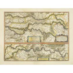
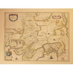
Descriptio fluminum Rheni, Vahalis et Mosae.
Shows that part of the central Netherlands where the three great rivers flow to within but a few kilometers of each below Wesel. The scale allows most of the larger towns...
Date: Amsterdam, 1647
Selling price: ????
Please login to see price!
Sold in 2018
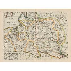
Estats de la Couronne de Pologne.
Map of Poland, from the first edition of the atlas L'Europe.Nicolas Sanson was to bring about the rise of French cartography, although the fierce competition of the Dutch...
Date: Paris, 1647
Selling price: ????
Please login to see price!
Sold in 2012
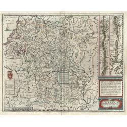
Magni Ducatus Lithuaniae ...
Decorative map of Poland and part of Russia up to the River Dnepr. Sailing ship, cartouche and coat of arms, plus a small mounted battle scene east of Brackaw and a secon...
Date: Amsterdam, 1647
Selling price: ????
Please login to see price!
Sold in 2012
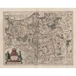
Poloniae Nova et Acurata Descriptio.
Decorative map of Poland, from Ioannis Ianssonni Novus Atlas, Sive Theatrum Orbis Terrarum : In quo Tabulae & Descriptiones omnium Regionum totius Universi accuratiss...
Date: Amsterdam, 1647
Selling price: ????
Please login to see price!
Sold in 2012
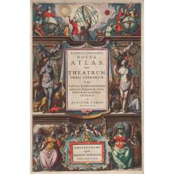
Ioannis Ianssonni Novus Atlas, ...
Title page of Ioannis Ianssonni Novus Atlas, Sive Theatrum Orbis Terrarum : In quo Tabulae & Descriptiones omnium Regionum totius Universi accuratissime exhibentur. I...
Date: Amsterdam, 1647
Selling price: ????
Please login to see price!
Sold in 2012
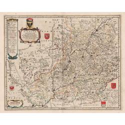
Silesia inferior, ...
Decorative map of Silesia, from Ioannis Ianssonni Novus Atlas, Sive Theatrum Orbis Terrarum : In quo Tabulae & Descriptiones omnium Regionum totius Universi accuratis...
Date: Amsterdam, 1647
Selling price: ????
Please login to see price!
Sold in 2012
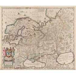
Novissima Russiae Tabula.
Decorative map of Russia, from Ioannis Ianssonni Novus Atlas, Sive Theatrum Orbis Terrarum : In quo Tabulae & Descriptiones omnium Regionum totius Universi accuratiss...
Date: Amsterdam, 1647
Selling price: ????
Please login to see price!
Sold in 2012
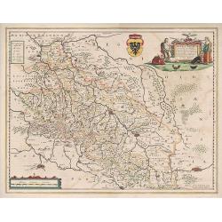
Silesiae Ducatus ...
Decorative map of Silesia, from Ioannis Ianssonni Novus Atlas, Sive Theatrum Orbis Terrarum : In quo Tabulae & Descriptiones omnium Regionum totius Universi accuratis...
Date: Amsterdam, 1647
Selling price: ????
Please login to see price!
Sold in 2012