Browse Listings
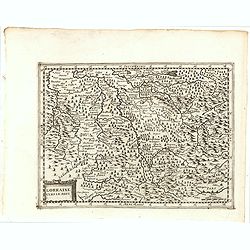
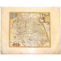
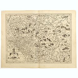
Lorraine Vers Le Midi.
Early map of Lorraine. With Latin text on verso. Engraved by Petrus Kaerius. Shortly after the publication of big folio-atlases the need was apparently felt for a smaller...
Date: Amsterdam, 1632
Selling price: ????
Please login to see price!
Sold in 2018
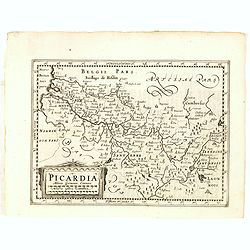
Picardia.
Early map of Northern France. With Latin text on verso. Engraved by Petrus Kaerius. Shortly after the publication of big folio-atlases the need was apparently felt for a ...
Date: Amsterdam, 1632
Selling price: ????
Please login to see price!
Sold in 2018
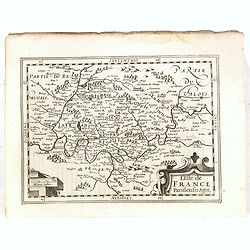
L'Isle de France..
Early map of Paris and surroundings. With Latin text on verso. Engraved by Petrus Kaerius. Shortly after the publication of big folio-atlases the need was apparently felt...
Date: Amsterdam, 1632
Selling price: ????
Please login to see price!
Sold in 2018
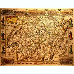
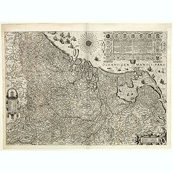
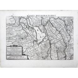
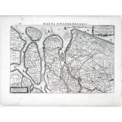
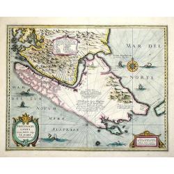
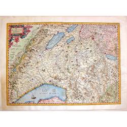
Nova Helvetiae Tabula.
A most decorative map with panoramic views of Lucerne, S.Gal, Bern, Solothurn, Schaffhausen in upper border and Basel and Zurich in lower left and right hand corner. In t...
Date: Amsterdam, 1632
Selling price: ????
Please login to see price!
Sold in 2016
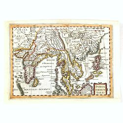
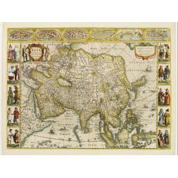
India Orientalis.
The map covers the region from India through southern China and the Philippines including all of the Malay peninsula with parts of northern Sumatra and Borneo. The Gulf o...
Date: Amsterdam, 1632
Selling price: ????
Please login to see price!
Sold in 2016
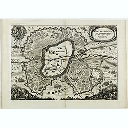
Castra Suecica ad Norimbergam. Kön. Schwedische Läger zu Nürnberg.
Nice print published by Mathias Merian publishing house. The Merian Journal presents the comprehensive defensive measures ordered by the Swedish king Gustav Adolf. Nuremb...
Date: Frankfurt, 1632
Selling price: ????
Please login to see price!
Sold in 2018
Belgicarum Provinciarum Descriptio. Gedruckt te Haerlem. . .
Very rare 2nd state of the map of the Low Countries, first published by Johannes and Baptist van Doetecum, in Haarlem 1588. This state of the map was only discovered in 1...
Date: Amsterdam, 1588/ The Hague, Henricus Hondius, 1632
Selling price: ????
Please login to see price!
Sold in 2019
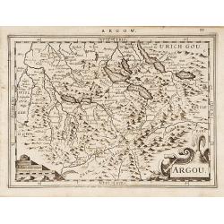
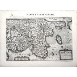
Argou.
Finely engraved map including the towns of Lucerne, Bern and Thuner- and Lucerner See.A profusion of place names and a nice title cartouche. From the scarce first Dutch e...
Date: Amsterdam 1632
Selling price: ????
Please login to see price!
Sold
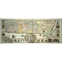
Chorographia Terrae Sanctae in Angustiorem Forman Redacta..
Large map of the Holy Land surrounded with panels of vignettes displaying sacred objects including a menorah, the arc of the covenant, the altar of sacrifices, the Tabern...
Date: Antwerp 1632
Selling price: ????
Please login to see price!
Sold
Asia recens summa cura delineata.
This is the rare early issue with decorative paneled borders. Originally engraved with plans of 6 towns at the top and bottom, c1630, this edition was printed after the l...
Date: Amsterdam 1632
Selling price: ????
Please login to see price!
Sold
![[Title page] Atlas sive Cosmographicae Meditationes..](/uploads/cache/23575-250x250.jpg)
[Title page] Atlas sive Cosmographicae Meditationes..
Decorative title page from an famous pocket atlas.
Date: Amsterdam 1632
Selling price: ????
Please login to see price!
Sold
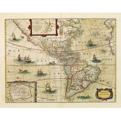
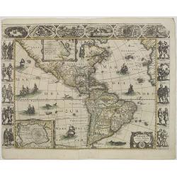
America noviter delineata.
With inset details of the North and South Poles, and several ships and sea-monsters. Hondius shows the imaginary island of Frisland, Southeast of Iceland, and gives Picar...
Date: Amsterdam, 1632
Selling price: ????
Please login to see price!
Sold in 2008
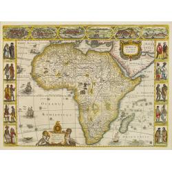
Africae nova Tabula.
Fine "carte à figures"- map of Africa, it's the issue of Jodocus Hondius map, with decorative borders on three sides. There are six ships in full sail on the A...
Date: Amsterdam, 1632
Selling price: ????
Please login to see price!
Sold in 2019
America noviter delineata. Auct. Judoco Hondio. / Ioannes Janssonius Excudit.
Third state of this very rare "carte à figures" - map. It is most easily distinguished by the chipped top right hand corner of the plate that appears in virtua...
Date: Amsterdam, 1632
Selling price: ????
Please login to see price!
Sold in 2011
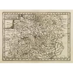
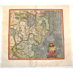
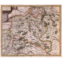
Lithuania.
Early map of Lithuania. No text on verso. Engraved by Petrus Kaerius.
Date: Amsterdam, 1632
Selling price: ????
Please login to see price!
Sold in 2009
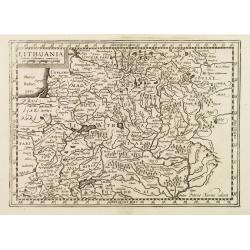
Lithuania.
Early map of Lithuania. With French text on verso. Engraved by Petrus Kaerius.
Date: Amsterdam, 1632
Selling price: ????
Please login to see price!
Sold in 2008
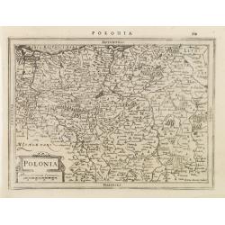
Polonia.
Early map of Poland. With Latin text on verso.
Date: Amsterdam, 1632
Selling price: ????
Please login to see price!
Sold in 2009
![Lithuania. [Lithuanie.]](/uploads/cache/22805-250x250.jpg)
Lithuania. [Lithuanie.]
Early map of present-day Poland and Lithuania. The map is fully engraved with rivers, lakes, forests and mountains and scores of place names. The Baltic is filled with a ...
Date: Amsterdam, 1632
Selling price: ????
Please login to see price!
Sold in 2010
Novissima Tabula Insular, Dordracensis, Alblasser, Crimper, Clundert etc...
A small, highly detailed map of Southern Holland published by Henricus Hondius(fl. 1624-1651) based on the survey by Floriszoon van Berckenrode. Includes the cities of Br...
Date: Amsterdam, 1632
Selling price: ????
Please login to see price!
Sold in 2010
Novissima Delflandiae, Schielandiae et circumiacentium insularum ut Voornae, Overflackeae, Goeree, Iselmonde aliarumque tabula.
A small, highly detailed map of Southern Holland published by Henricus Hondius(fl. 1624-1651) based on the survey by Floriszoon van Berckenrode. Includes the cities of Ro...
Date: Amsterdam, 1632
Selling price: ????
Please login to see price!
Sold in 2010
Totius Hollandiae Septentrionalis vulgo Westfrisiae novissima tabula. . .
A small, highly detailed map of Northern Holland, including the Westfrisia region, published by Henricus Hondius(fl. 1624-1651) based on the survey by Floriszoon van Berc...
Date: Amsterdam, 1632
Selling price: ????
Please login to see price!
Sold in 2010
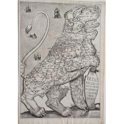
Leo Belgicus.
The largest & rarest of the famous 'Strada Leo Belgicus', here in its first state. This version stood model for nearly all subsequent lions in other Strada editions. ...
Date: Rome, 1632
Selling price: ????
Please login to see price!
Sold in 2020
Chorographia Terrae Sanctae in Angustiorem formam Redacta et ex Variis Auctoribus a Multis Erroribus Expurgata.
A highly attractive and large map of the Holy Land, printed from two plates joined. The map ranges from Syria and Tyre southward as far as the Sinai, Egypt and Thebes. Th...
Date: Antwerp, 1632
Selling price: ????
Please login to see price!
Sold in 2021
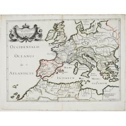
Patriarchatus Romanus . . .
A rare map of the Roman Empire, extending from North Africa to Great Britain and east to the Balkans, adorned with a beautiful cartouche with 2 mermaids. From Melchior Ta...
Date: Paris, 1632
Selling price: ????
Please login to see price!
Sold in 2021
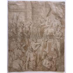
Christ in front of one of his judges.
Drawing: pen/brush in brown, brown wash. Anonymous, German School. Pedigree unknown. Dated: first half of the 17th century, possibly ca. 1611-1630. Depicted is a handcuff...
Date: Stuttgart, 1611-1633
Selling price: ????
Please login to see price!
Sold in 2020
Carte Generalles des Royaumes & Provinces, de la haute et basse Allemagne, Reveües et Corigées, par le Sr. Tassin, Geographe Ordinaire de Sa Ma.té.
Illustrated with 51 (of 52) maps of The Netherlands, Belgiem, Germany, France, Poland, Bohemia...Christophe Tassin, who was active from 1633 till 1655, was appointed 'roy...
Date: Paris, [Sébastien Cramoisy], 1633
Selling price: ????
Please login to see price!
Sold in 2024
Freti Magellanici ac novi Freti vulgo Le Maire exactissima delinatio...
Decorative map of the Straits of Magellan, Le Mair Strait, Fire Lands, and the southern tip of Patagonia. The coastlines of Tierra del Fuego are incomplete. Fully engrave...
Date: Amsterdam, 1633
Selling price: ????
Please login to see price!
Sold in 2013
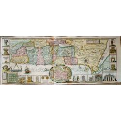
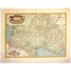
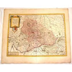
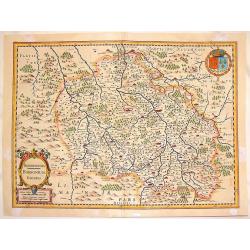
Lorraine, vers le Midy.
Copper-engraving, Decorative map showing the center of the Lorraine. The map provides an enormous amount of place names, small villages, and towns. As well rivers, lakes,...
Date: Amsterdam, 1633
Selling price: ????
Please login to see price!
Sold in 2012
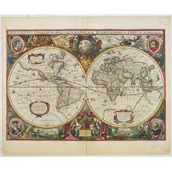
Nova Totius Terrarum Orbis Geographica. .
A first state with the date 1630. In near to mint condition. One of the most beautiful world maps ever engraved and one of the most influential in promulgating the Califo...
Date: Amsterdam, 1630 -1633
Selling price: ????
Please login to see price!
Sold in 2012
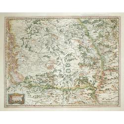
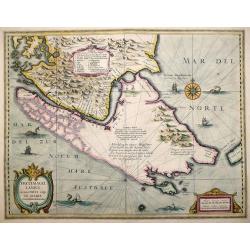
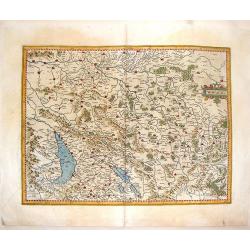
Austria Archiducatus auctore Wolfgango Lazio.
Showing the Danube and its cities. Bordering Bohemia, Moravia, Salzburg, Corinthian and Styria. Vienna is prominently featured and the map is filled with villages, cities...
Date: Amsterdam, 1633
Selling price: ????
Please login to see price!
Sold in 2012
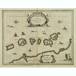
Insularum Moluccarum Nova descriptio.
A decorative map of some of the Spice Islands, off the west coast of the island of Halmahera in the eastern part of the archipelago. The map is oriented with north to the...
Date: Amsterdam, after 1633
Selling price: ????
Please login to see price!
Sold in 2017
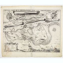
Nouvelle carte de S. Stevens=Weert avec ces fortifications. Anno 1633.
A very rare map of the siege of Stevensweert. In upper part a second map of the river Maas from Maastricht until Venlo. Prepared P. Chatel and F. Boullain, engraved by A....
Date: Brussels, 1633
Selling price: ????
Please login to see price!
Sold in 2015
Freti Magellanici ac novi Freti vulgo Le Maire exactissima delinatio...
Decorative map of the Straits of Magellan, Le Mair Strait, Fire Lands, and the southern tip of Patagonia. The coastlines of Tierra del Fuego are incomplete. Fully engrave...
Date: Amsterdam, 1633
Selling price: ????
Please login to see price!
Sold in 2013
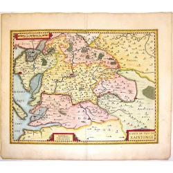
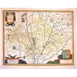
Carte du Pais de Xaintonge.
Decorative copperplate map of the Xaintonge region of France extending from the Atlantic Ocean (La Rochelle, Ille Oleron) to the River Tardoire in the department of Poito...
Date: Amsterdam, 1633
Selling price: ????
Please login to see price!
Sold in 2016
Das Wiflispur Gergov.
This fine copperplate map of Switzerland features the region north east of Geneva. It is decorated by a fancy belted title cartouche and a ship. It is from "Atlas, d...
Date: Amsterdam, 1633
Selling price: ????
Please login to see price!
Sold in 2013
Ultoniae Orientalis Pars.
Early map featuring the Down & Antirm counties of Northern Ireland. Interesting, decorative combination title / scale cartouche and the sea is in moire pattern. Frenc...
Date: Amsterdam, 1633
Selling price: ????
Please login to see price!
Sold in 2015
Miliaria Burgundie Comitatus Commonia.
Fine 381 year old map of Franche Comte (France & Switzerland) including detail of cities,mountains, rivers, lakes and trees. Small decorative combination title & ...
Date: Amsterdam, 1633
Selling price: ????
Please login to see price!
Sold in 2015
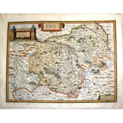
France, Picardie, Champaigne cum Regionibus Adiacentibus.
Pleasant copperplate map of Picardie-Champagne featuring matching chain title & scale cartouches. Notice the crow perched on the title cartouche.Gerard Mercator (1512...
Date: Amsterdam, 1633
Selling price: ????
Please login to see price!
Sold in 2015
Aquitania Australis Regnu Arelatense Cum Consinijs.
Map of Southern France (from the Pyrenees to Monaco),featuring Auvergne, Bourgogne, Limousine, Provence and Languedoc. Decorated with two matching strapwork cartouches (...
Date: Amsterdam, 1633
Selling price: ????
Please login to see price!
Sold in 2013
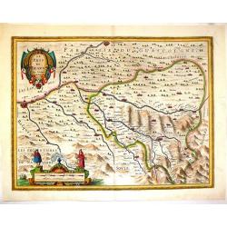
Le Pais de Bearn, avec Privilege du Roy.
Handsome copperplate map of Southern France featuring the Bearn region. The major cities shown include Bayonne, Oloron, St. Esprit, Pau, Orthes etc. The Pyrenese Mountain...
Date: Amsterdam, 1633
Selling price: ????
Please login to see price!
Sold in 2014
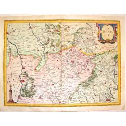
Description du Blaisois, Anno 1630.
Superb copperplate map of the Blois region of France with THREE very fancy cartouches. The title and scale cartouches have faces of monsters. The map features the Loire R...
Date: Amsterdam, 1633
Selling price: ????
Please login to see price!
Sold in 2016
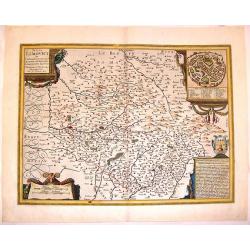
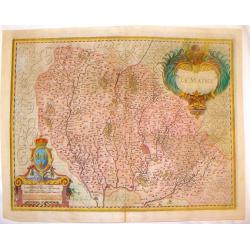
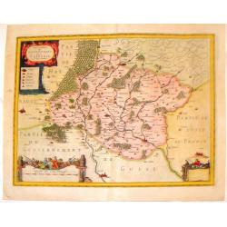
Totius Lemovici et Confinium Provinciarum.
A very decorative map of Limoge, France prepared by Jean du Fayen featuring FOUR lovely cartouches. The cartouche in the upper right corner shows a bird's-eye view of Lim...
Date: Amsterdam, 1633
Selling price: ????
Please login to see price!
Sold in 2015
Beauvaisis Comitatus Belovacium.
Pleasing map of the Beuavais region of France. Decorative title cartouche with royal arms and drapery style scale cartouche with comapass. Gerard Mercator (1512-1594) wa...
Date: Amsterdam. 1633
Selling price: ????
Please login to see price!
Sold in 2016
Biturigum, le Duche de Berry.
Fine detailed copper engraving of the Duchy of Berry including the cities of Nancy, Bourges and St. Marceau. Three decorative cartouches including a rare castle cartouche...
Date: Amsterdam, 1633
Selling price: ????
Please login to see price!
Sold in 2015
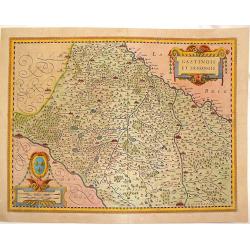
Gastinois et Senonois.
Pleasant copperplate map of regional France with detailed presentation of rivers, lakes, cities towns and forests. Cities include Orleans, Montargis, Sens, Corbeil and Me...
Date: Amsterdam, 1633
Selling price: ????
Please login to see price!
Sold in 2016
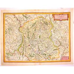
Carte du Pais et Duche de Nivernois.
Fin e map of the Duchy of Nivernois in the Burgogne region of France. Fully detailed with cities, towns, mountains, rivers, lakes and forests. Features tht towns of Bourg...
Date: Amsterdam, 1633
Selling price: ????
Please login to see price!
Sold in 2013
Bourbonois Borbonium Ducatus.
Fine copper engraved map of the Bourbonois region of France. The map shws the Loire River and the cities of Rendan, Moulins, bourbon, Nevers and Brulles. The title/scale ...
Date: Amsterdam, 1633
Selling price: ????
Please login to see price!
Sold in 2013
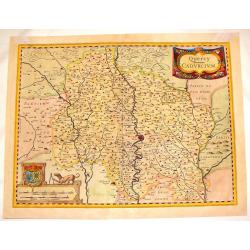
Quercy Cadurcium.
Striking map of the Quercy region of France. The major city is Caors or Cahors. There are two truly remarkable cartouches including the scale cartouche featuring a dog wi...
Date: Amsterdam, 1633
Selling price: ????
Please login to see price!
Sold in 2016
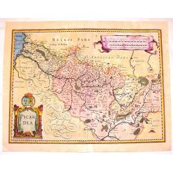
Picardia.
Attractive hand-colored, copper engraved map of Picardie, the most northwestern region of France, bordering with Belgium. It features the cities of Amiens, Abbeville and ...
Date: Amsterdam, 1633
Selling price: ????
Please login to see price!
Sold in 2016
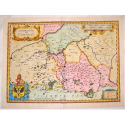
L'Archevesche de Cambray.
Beautiful hand-colored, decorative map of the Cambray region of France that features the cities of Cambray, Valencenne, Douay, and Bouchain. It has four cartouches, one i...
Date: Amsterdam. 1633
Selling price: ????
Please login to see price!
Sold in 2016
La Beauce.
Decorative, hand-colored, copperplate map featuring the Beauce Region of France.Showing miniature views of Paris, Orleans, Chartres, Oriens and Blois. Seine and Loire riv...
Date: Amsterdam, 1633
Selling price: ????
Please login to see price!
Sold in 2016
Le Maine.
Striking hand-colored copperplate map featuring the French province of Le Mans. It is very detailed with cities, towns, rivers, lakes and forests. Two lovely cartouches, ...
Date: Amsterdam. 1633
Selling price: ????
Please login to see price!
Sold in 2016
Description du Gouvernement de la Cappelle.
Striking copper engraved map with three fancy cartouches. Features Cappellein, the region of the Nord-Pas-de-Calais in France. Engraved by Pierre Boubon (1598-1667) Gera...
Date: Amsterdam, 1633
Selling price: ????
Please login to see price!
Sold in 2016
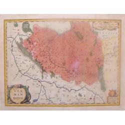
Vermandois.
Hand-colored copper engraved map featuring the region of Vernandois in the northern province of Picardy. The main cities are St. Quentin, Han & Perone. There are thre...
Date: Amsterdam, 1633
Selling price: ????
Please login to see price!
Sold in 2015
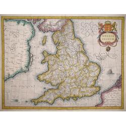
Anglia Regnum.
A later edition of the map that first appeared in Part III of the Mercator Atlas published in Duisburg 1595: The main differences are the cartouch and the size of The Isl...
Date: Duisburg/Amsterdam, 1595/1633
Selling price: ????
Please login to see price!
Sold in 2014
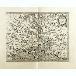
Taurica Chersonesus.
One of the earliest detailed maps of the Crime and Ukraine. Mercator's fine map of the region north of the Black sea encompasses the Crimea and the southern steppes of Uk...
Date: Amsterdam 1633
Selling price: ????
Please login to see price!
Sold in 2018
Polonia et Silesia.
Fine and important map of Poland, including Warsaw, Krakow, Oppeln, Breslau, Gnezna, Graudenz, Lublin etc.Mercator was born in Rupelmonde in Flanders and studied in Leuve...
Date: Amsterdam, 1633
Selling price: ????
Please login to see price!
Sold in 2014
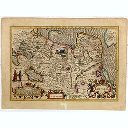
Tartaria.
Published in Hondius' editions of the Mercator Atlas from 1606 onwards, showing China, Korea as an island, and the northern Pacific coast of America showing the two conti...
Date: Amsterdam, 1633
Selling price: ????
Please login to see price!
Sold in 2015
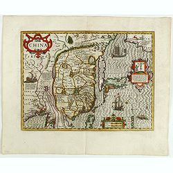
China.
Important map of China. Besides China, the map depicts Korea as an elongated island and Japan from the Teixeira model of 1595. Decorated with strap work cartouches, a Eur...
Date: Amsterdam, 1633
Selling price: ????
Please login to see price!
Sold in 2015
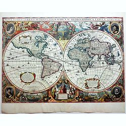
Nova Totius Terrarum Orbis Geographica. . .
The first of four states of the map. French text on verso. One of the most beautiful world maps ever engraved and one of the most influential in promulgating the Californ...
Date: Amsterdam, 1630-1633
Selling price: ????
Please login to see price!
Sold in 2015
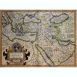
Turcici Imperii Imago.
A very decorative map of the Turkish Empire.
Date: Amsterdam, 1633
Selling price: ????
Please login to see price!
Sold in 2018
Lithuania.
One of the earliest maps of Lithuania and Poland by Mercator.
Date: Amsterdam, 1633
Selling price: ????
Please login to see price!
Sold in 2017
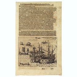
Schlacht for Manille.
Scarce print with German text sheet showing the Dutch anchored near Manila, the Spanish, with 7 soldiers to each Dutchman, tried to conquer the Dutch with their great bat...
Date: Frankfurt, M.Merian, 1633
Selling price: ????
Please login to see price!
Sold in 2017
![[Discovery of the Magellan Strait.]](/uploads/cache/39903-250x250.jpg)
[Discovery of the Magellan Strait.]
Scarce print with a German text sheet shows the great Portuguese explorer, Ferdinand Magellan, navigating the dangerous waters of the channel that bears his name. On 21st...
Date: Frankfurt, M.Merian, 1633
Selling price: ????
Please login to see price!
Sold in 2017
![[Dutch fight with the local Indians in the Magellan Strait.]](/uploads/cache/39904-250x250.jpg)
[Dutch fight with the local Indians in the Magellan Strait.]
Scarce print with a German text sheet shows Noort’s fleet in the Magellan Straits, the Dutch visited an island near Cape Nassau. It was inhabited by Fuegian Indians who...
Date: Frankfurt, M.Merian, 1633
Selling price: ????
Please login to see price!
Sold in 2020
![[Dutch become stranded in the Magallen Strait.]](/uploads/cache/39905-250x250.jpg)
[Dutch become stranded in the Magallen Strait.]
Scarce print with a German text sheet. While the Dutch were killing the birds on Penguin Island, there was a great storm and the waves damaged their boat so badly that it...
Date: Frankfurt, M.Merian, 1633
Selling price: ????
Please login to see price!
Sold in 2023
![[Cavendish reaches Deseado.]](/uploads/cache/39906-250x250.jpg)
[Cavendish reaches Deseado.]
Scarce print with a German text sheet. In December, 1586, during his round-the-world voyage, Cavendish’s fleet landed on the Atlantic coast of Patagonia, near some isla...
Date: Frankfurt, M.Merian, 1633
Selling price: ????
Please login to see price!
Sold in 2017
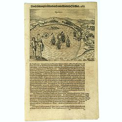
Quintero.
Scarce print with a German text sheet. On 13th June, 1615, Spilbergen’s fleet entered the beautiful Bay of Quintero (A), and anchored there (C). Again the Dutch went as...
Date: Frankfurt, M.Merian, 1633
Selling price: ????
Please login to see price!
Sold in 2017
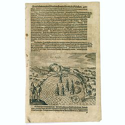
Val Parysa.
Scarce print with a German text sheet. In the June of 1615, the Dutch fleet reached the town of Valparaíso. The natives were dressed as shown (I). The fleet (D) anchored...
Date: Frankfurt, M.Merian, 1633
Selling price: ????
Please login to see price!
Sold in 2017
![[Drake capturing of St. Augustine in Florida].](/uploads/cache/39913-250x250.jpg)
[Drake capturing of St. Augustine in Florida].
Scarce print with a German text sheet showing Drake's men overrunning the settlement of St. Augustine. Fleet is anchored in the bay. From de Bry's "Great American Vo...
Date: Frankfurt, M. Merian, 1633
Selling price: ????
Please login to see price!
Sold in 2017
![[Drake reaches the Rio de la Plata].](/uploads/cache/39915-250x250.jpg)
[Drake reaches the Rio de la Plata].
Scarce print with a German text sheet showing Drake’s fleet of five ships reaching the Rio de la Plata in April, 1578. One of the ships in poor repair had been slowing ...
Date: Frankfurt, M.Merian, 1633
Selling price: ????
Please login to see price!
Sold in 2017
Aquapolque.
Scarce print with a German text sheet. The Dutch had already captured many Spaniards and, in October 1615 when their fleet reached Acapulco, they exchanged them for provi...
Date: Frankfurt, M.Merian, 1633
Selling price: ????
Please login to see price!
Sold in 2020
![[Spilbergen's fleet lands near Manzanillo].](/uploads/cache/39918-250x250.jpg)
[Spilbergen's fleet lands near Manzanillo].
Scarce print with a German text sheet. A few miles north of Manzanillo is the natural harbour of Santiago,(St. Jago) where Spilbergen’s fleet, marked (A), anchored. A s...
Date: Frankfurt, M.Merian, 1633
Selling price: ????
Please login to see price!
Sold in 2020
![[The French reach Port Royal].](/uploads/cache/39919-250x250.jpg)
[The French reach Port Royal].
Scarce print with a German text sheet. When the French arrived, they called it Portuus Regalis or Port Royal because of its size and beauty. There they brought in the sai...
Date: Frankfurt, M.Merian, 1633
Selling price: ????
Please login to see price!
Sold in 2018
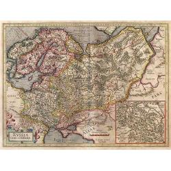
Russia cum confinijs.
An extremely decorative and historic map, showing Scandinavia, Russia, and the regions directly south of the Crimea. With an inset map of the central region round Moscow,...
Date: Amsterdam, 1633
Selling price: ????
Please login to see price!
Sold in 2017
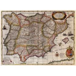
Typus Hispaniae.
A decorative map of the Kingdom of Spain and Portugal by Joan Janssonius, after the cartographic source by Hessel Gerard. Embellished by sailing ship, compass roses, and ...
Date: Amsterdam, 1633
Selling price: ????
Please login to see price!
Sold in 2017
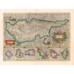
Cyprus Ins.
A decorative map of Cyprus, with six inset maps of Stalimini, Chius, Mitilene, Negroponte, Cerigo, and Rhodes.
Date: Amsterdam, 1633
Selling price: ????
Please login to see price!
Sold in 2017
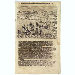
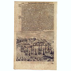
Manila.
Scarce print with German text sheet showing the harbour of Manila, carefully depicted here, is a good place for ships. The letter ‘A’ is the harbour itself. B: Shows ...
Date: Frankfurt, M.Merian, 1633
Selling price: ????
Please login to see price!
Sold in 2017
![[Sebald de Weert arriving in South America].](/uploads/cache/40158-250x250.jpg)
[Sebald de Weert arriving in South America].
Scarce print (150x175mm.) showing Sebald de Weert making landfall in South America on a German text sheet taken from a first edition of Johann Ludwig Gottfried's "Ne...
Date: Frankfurt, M.Merian, 1633
Selling price: ????
Please login to see price!
Sold in 2017
![[Mexican history plate].](/uploads/cache/40175-250x250.jpg)
[Mexican history plate].
Scarce print (150x177mm.) on a German text sheet taken from a first edition of Johann Ludwig Gottfried's "Newe Welt Vnd Americanische Historien/ Jnhaltende Warhaffti...
Date: Frankfurt, M.Merian, 1633
Selling price: ????
Please login to see price!
Sold in 2017