Search Listings matching "cyprus"
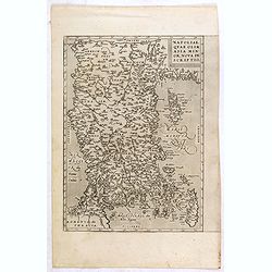
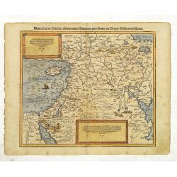
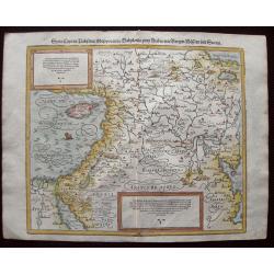
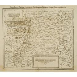
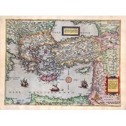
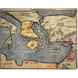
Natoliae Quae Olim Asia Minor, Nova de Scriptio.
Detailed map of Turkey, including Cyprus by Abraham Ortelius, from his "Theatrum Orbis Terrarum", the first modern atlas of the world.East to the top. Latin tex...
Place & Date: Antwerp, 1587
Selling price: $300
Sold in 2015
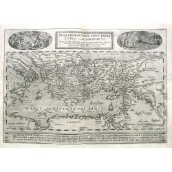
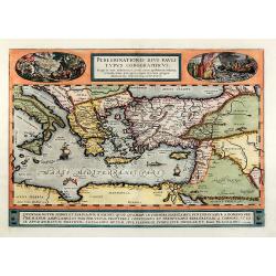
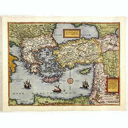
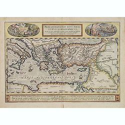
Peregrinationis Divi Pauli Typus Corographicus...
Ortelius's map of Paulus's travels from his Atlas Theatrum Orbis Terrarum. It covers the Mediterranean Sea from Italy and Sicily until the Near East and Egypt, with Cypru...
Place & Date: Antwerp, 1587
Selling price: $180
Sold in 2019
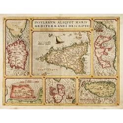
Insularum Aliquot Maris Mediterranei Descriptio.
The decorative composite map of six Mediterranean islands. The larger Sicily map is surrounded by maps of Sardinia, Corfu, Zerbi, Elba, and Malta. Each map is well detail...
Place & Date: Antwerp, 1587
Selling price: $800
Sold
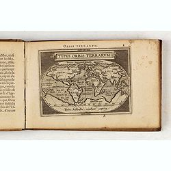
Epitome. Du Theatre du Monde d'Abraham Ortelius.
Third French text edition in an oblong format of this illustrated treatise of geography, which is considered as the first modern pocket-atlas. The atlas was printed by Pl...
Place & Date: Antwerp, 1588
Selling price: $3500
Sold in 2020
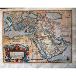
Syria / Cypern / Palestina Mesopotamia / Babylonia / zwen Arabia / mit Bergen / Wasseren und Stetten.
A famous wood block map of the Near East, including Cyprus, Palestine, Iran and Iraq, etc. From his "Cosmographia", that great compendium of Renaissance knowled...
Place & Date: Basle, c.1588
Selling price: $200
Sold in 2012
Syria, Cypern, Palestina, Mesopotamia, Babylonia, zwey Arabia mit Bergen, Waesseren und Stetten.
A famous woodblock map of the Near East, including Cyprus, Palestine, Iran, Iraq, etc. From his 'Cosmographia,' that great compendium of Renaissance knowledge. In 1588, n...
Place & Date: Basle, S.H. Petrie, 1588
Selling price: $110
Sold in 2014
Syria, Cypern, Palestina, Mesopotamia..
A famous wood block map of the Near East, including Cyprus, Palestine, Iran and Iraq, etc. From his Cosmographia , that great compendium of Renaissance knowledge. In 1588...
Place & Date: Basle c.1588
Selling price: $210
Sold
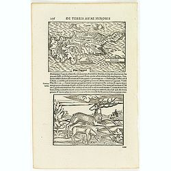
Cyprus.
Two woodcuts on one page. In upper part a map of Cyprus, in lower part a jumping deer and a sheep drinking water. The drinking sheep with old pen scratches. . From a Lati...
Place & Date: Basle, 1550-1590
Selling price: $120
Sold in 2012
![In monte casio iuxta ostracinam. . . [Israel with Cyprus]](/uploads/cache/32575-250x250.jpg)
In monte casio iuxta ostracinam. . . [Israel with Cyprus]
On recto a woodcut engraved map of Israel and Cyprus. Engraved by Hans Rudolf Manuel Deutsch, with his monogram. From a Latin text edition of his Geographia , that great ...
Place & Date: Basle, 1550-1590
Selling price: $20
Sold in 2015
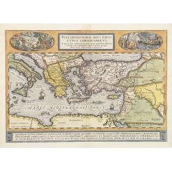
Turcici Imperii Descriptio.
The most famous of all the sixteenth-century maps of the Middle East. It extends from Greece to Arabia and covers the Cradle of Civilisation region. The Eastern Mediterra...
Place & Date: Antwerp, ca 1590
Selling price: $900
Sold in 2016
Natoliae..Aegypti recentior..Carthaginis (3 maps on 1 sheet)
3 Maps on one sheet. Map to the left east to the top. Detailed map Turkey, including Cyprus and Crete. Also map of the Nile delta and another map of Tunis.
Place & Date: Antwerp 1590
Selling price: $310
Sold
Natoliae..Aegypti Recentior..Carthaginis.. (3 maps on 1 sheet)
3 Maps on one sheet. Map to the left east to the top. Detailed map Turkey, including Cyprus and Crete. Also map of the Nile delta and another map of Tunis.
Place & Date: Antwerp 1590
Selling price: $325
Sold
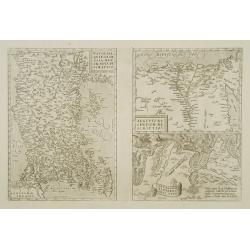
![[Set of 5 maps of the Holy Land: Paradise, Canaan, Israel & Egypt, the Eastern Mediterranean. . .]](/uploads/cache/48407-250x250.jpg)
[Set of 5 maps of the Holy Land: Paradise, Canaan, Israel & Egypt, the Eastern Mediterranean. . .]
A lovely set of biblical maps of the Holy Land and its surrounds and, the Eastern Mediterranean by Cloppenburg, and engraved by Baptista Deuticum. The first map is an ear...
Place & Date: Amsterdam, ca 1590
Selling price: $1700
Sold in 2022
Peregrinationis divi Pauli typus corographicus
Hand colored map of the Eastern Mediterranean by Abraham Ortelius. Covering the Mediterranean Sea between Israel and Sicily with Cyprus, Italy, Greece and Turkey. With tw...
Place & Date: Antwerp, 1592
Selling price: $700
Sold in 2010
Natoliam Moderni dicunt tam partem quam Asiam minrem appelauere veteres (with Cyprus)
Engraved by Van Deutecum, this is a spectacular example of the 1593 edition of the very rare De Jode's map of the Eastern Mediterranean and Asia Minor. It has two title c...
Place & Date: Antwerp, 1593
Selling price: $2900
Sold in 2014
Natoliam Moderni dicunt tam partem quam Asiam minrem appelauere veteres. (with Cyprus).
Engraved by Van Deutecum, this is a spectacular example of the 1593 edition of the very rare De Jode's map of the Eastern Mediterranean and Asia Minor. It has two title c...
Place & Date: Antwerp, 1593
Selling price: $3900
Sold in 2014
![Primae Partis Asiae accurata delineatio... [shows Cyprus]](/uploads/cache/97442-250x250.jpg)
Primae Partis Asiae accurata delineatio... [shows Cyprus]
Engraved by the van Deutecum brothers, based upon an earlier map by Gastaldi.0De Jode's rare map of the region, bounded by the Black Sea and Mediterranean in the West, an...
Place & Date: Antwerp, 1593
Selling price: $1250
Sold in 2017
Primae Partis Asiae.
Includes the eastern part of the Mediterranean with Cyprus and Holy Land and the Black Sea with Turkey in between, the northern part of Egypt, Arabia Persia and Afghanist...
Place & Date: Antwerp 1593
Selling price: $1475
Sold
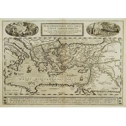
Peregrinationis Divi Pauli Typus?
A splendid map depicting the travels of Paulus. With two fine scenes in top. Showing the countries along the Mediterranean, including Cyprus and Italy. Based on Mercator'...
Place & Date: Antwerp 1595
Selling price: $650
Sold in 2008
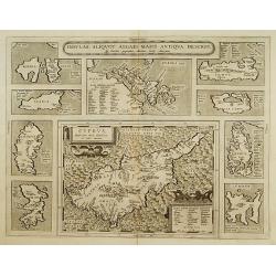
Insular. Aliquot Aegaei Maris Antiqua Descrip.
Ten maps on one plate. Showing Rinia and Dilos, Nicaria, Euboea, Samos, Keos (near Euboea), Rhodus, Chios, Cyprus, Lesbos, Lemnos.This map belongs to a series of historic...
Place & Date: Antwerp 1595
Selling price: $600
Sold
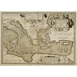
Aeneae Troiani navigatio..
After the destruction of Troy, Aenaeas is reported to have roamed the seas for seven years, as described in the writings of Xenophon, Ovidius, Lycrophonous, but most exte...
Place & Date: Antwerp 1595
Selling price: $320
Sold
Peregrinationis Divi Pauli Typus Corographicus . . .
A splendid map depicting the travels of Paulus. With two fine scenes in top. Showing the countries along the Mediterranean, including Cyprus and Italy. Based on Mercator'...
Place & Date: Antwerp, 1595
Selling price: $1300
Sold
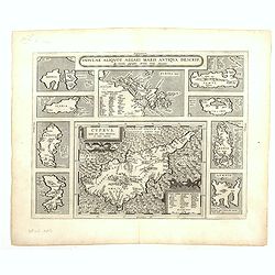
Cyprus - Insular Aliquot Aegaei maris antiqua descrip.
Ten maps on one sheet. With large map of Cyprus. Provenance: This map is from the personal collection of dr. Marcel van den Broecke, author of Ortelius Atlas Maps An...
Place & Date: Antwerp, 1595
Peregrinationis Divi Pauli Typus...
A splendid map depicting the travels of Paulus. With two fine scenes in top. Showing the countries along the Mediterranean, including Cyprus and Italy. Based on Mercator'...
Place & Date: Antwerp, 1595
Selling price: $600
Sold in 2014
Tafel der Lender / darin der Apostel Paulus geprediget hat.
Woodcut showing the Eastern Mediterranean from the "Itinerarium Sacrae Scripturae", showing Italy, Sicily, Greece, Cyprus, Asia Minor, the Holy Land and North A...
Place & Date: Magdeburg, 1595
Selling price: $340
Sold in 2017
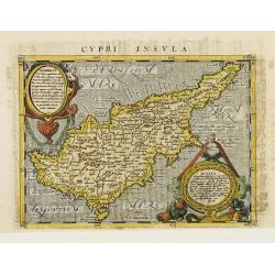
Cypri Insvla.
Lovely copper engraved map of the island of Cyprus featuring two large cartouches and fancy lettering in the seas. Good detail in the interior.The map comes from a scarce...
Place & Date: Cologne 1597
Selling price: $730
Sold
Natoliae quae olim Asia minor.
East to the top. Detailed map Turkey, including Cyprus and Crete. German text on verso.
Place & Date: Antwerp, 1598
Selling price: $160
Sold in 2010
![Rovigno [View of Rovinj]](/uploads/cache/45192-250x250.jpg)
Rovigno [View of Rovinj]
Very rare view of Rovinj in Croatia situated on the north Adriatic Sea. Located on the western coast of the Istrian peninsula, it is a popular tourist resort and an activ...
Place & Date: Venice, Giacomo Franco, 1598
Selling price: $150
Sold in 2023
![[The disposition of the Holy League fleet and that of the Ottoman Army during the Battle of Lepanto.]](/uploads/cache/45225-250x250.jpg)
[The disposition of the Holy League fleet and that of the Ottoman Army during the Battle of Lepanto.]
Very rare print of the disposition of the Holy League fleet and that of the Ottoman Army (semicircle) during the Battle of Lepanto (1571), published in the first edition ...
Place & Date: Venice, Giacomo Franco, 1598
Selling price: $90
Sold in 2023
![Golfo di Lepanto. [Map of the Gulf of Nafpaktos]](/uploads/cache/45227-250x250.jpg)
Golfo di Lepanto. [Map of the Gulf of Nafpaktos]
Very rare map of Gulf of Nafpaktos, known as Lepanto. It is named for Naupaktos, an important Athenian naval station in the Peloponnesian war. As a strategically crucial ...
Place & Date: Venice, Giacomo Franco, 1598
Selling price: $250
Sold in 2023
![Scharpanto [Map of Scharpantos]](/uploads/cache/45234-250x250.jpg)
Scharpanto [Map of Scharpantos]
Very rare map of Karpathos Island published in the first edition of "Viaggio da Venetia, a Costantinopoli. Per Mare, e per Terra, & infieme quello di Terra Santa...
Place & Date: Venice, Giacomo Franco, 1598
Selling price: $450
Sold
![Cipro [Map of Cyprus]](/uploads/cache/45237-250x250.jpg)
Cipro [Map of Cyprus]
Very rare map of Cyprus Island published in the first edition of "Viaggio da Venetia, a Costantinopoli. Per Mare, e per Terra, & infieme quello di Terra Santa. D...
Place & Date: Venice, Giacomo Franco, 1598
Selling price: $625
Sold in 2020
![Famagosta [Plan of Famagusta]](/uploads/cache/45239-250x250.jpg)
Famagosta [Plan of Famagusta]
Very rare plan of Famagusta, situated east of Nicosia and possesses the deepest harbour of the island. During the medieval period (especially under the maritime republics...
Place & Date: Venice, Giacomo Franco, 1598
Selling price: $375
Sold in 2020
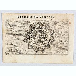
Nicosia.
Very rare view of Nicosia, also known as Lefkosia, which is the divided capital city of Cyprus. Published in the first edition of "Viaggio da Venetia, a Costantinopo...
Place & Date: Venice, Giacomo Franco, 1598
Selling price: $850
Sold in 2020
![Polla/Viaggio Da Venetia [Pola in Istria] Rare 1st edition](/uploads/cache/84452-250x250.jpg)
Polla/Viaggio Da Venetia [Pola in Istria] Rare 1st edition
Very rare view of the City of Pola in Istria. From the rare first edition of "Viaggio da Venetia, a Costantinopoli. Per Mare, e per Terra, & infieme quello di Te...
Place & Date: Venice, Giacomo Franco, 1598
Selling price: $130
Sold in 2021
![[View of Navarino]](/uploads/cache/45229-250x250.jpg)
[View of Navarino]
Very rare view of Navarino published in the first edition of "Viaggio da Venetia, a Costantinopoli. Per Mare, e per Terra, & infieme quello di Terra Santa. Da Gi...
Place & Date: Venice, Giacomo Franco, 1598
Selling price: $135
Sold in 2022
![[View of Napoli Romania]](/uploads/cache/45231-250x250.jpg)
[View of Napoli Romania]
Very rare view of Nafplion published in the first edition of "Viaggio da Venetia, a Costantinopoli. Per Mare, e per Terra, & infieme quello di Terra Santa. Da Gi...
Place & Date: Venice, Giacomo Franco, 1598
Selling price: $200
Sold in 2022
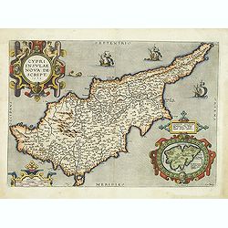
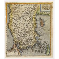
Cypri Insulae Nova descript. 1573.
This is a beautiful copy of a classic map of Cyprus. It is the earliest obtainable version of the best map of Cyprus made to date. Ortelius based his map upon that publis...
Place & Date: Antwerp, 1598
Selling price: $2000
Sold in 2012
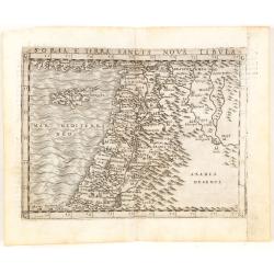
Soria et Terra Santa nuova tavola.
Early map of this classical map of the Holy Land, including Cyprus, prepared by Giovanni Botero. The copper plate was however later used by Giuseppe Rosaccio's expended e...
Place & Date: Venice, 1598
Selling price: $200
Sold in 2014
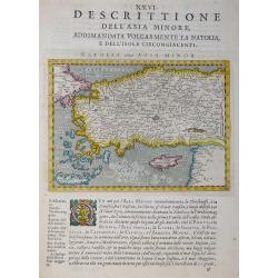
Desrittione Dell'Asia Minore addimandata volgarmente La Natolia e dell'Isole circongiacenti.
Map shows Turkey, Cyprus and Greek Islands along Turkish coast south to the Island of Crete (Candia) and the Syrian coast. Verso: related text.ublished in “Geografia ci...
Place & Date: Venice, 1598
Selling price: $100
Sold in 2017