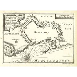
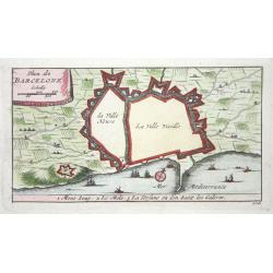
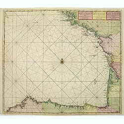
Plan de la Ville det Port de Barcelone.
An attractive chart centered Barcelona. With scale and large compass-rose. Dated 1727, with the privilege of the King. From : Recueil des Plusieurs plans des ports et rad...
Place & Date: Marseille, 1730
Selling price: $400
Sold in 2010
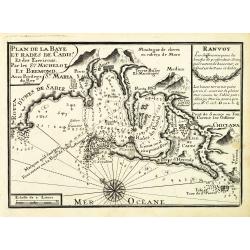
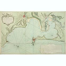
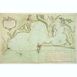
Plan de la Baye et Rade de Cadis.
An attractive chart of Cadiz. With scale and large compass-rose. Dated 1730, with the privilege of the King. From : Recueil des Plusieurs plans des ports et rades de la M...
Place & Date: Marseille, 1730
Selling price: $300
Sold in 2012
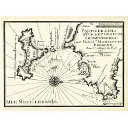
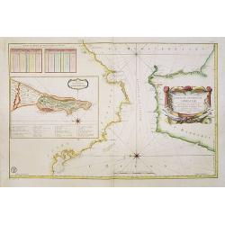
Partie de l'isle d'Yvice, et des isles fromentières.
An attractive chart centered on the south coasts of Ibiza and the Island of Formentera. With scale and large compass-rose. Dated 1730, with the privilege of the King. Fro...
Place & Date: Marseille, 1730
Selling price: $300
Sold
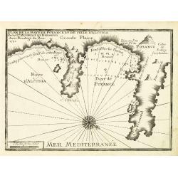
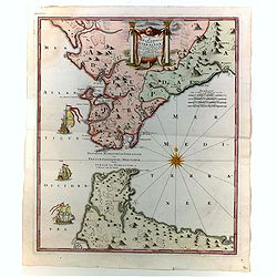
Plan de la Baye de Poyance et de celle d'Alcudia.
An attractive chart centered on the Mediterranean. With scale and large compass-rose. Dated 1727, with the privilege of the King. From : Recueil des Plusieurs plans des p...
Place & Date: Marseille, 1730
Selling price: $240
Sold
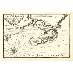
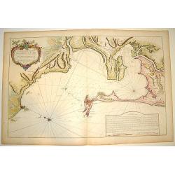
Plan de la Baye et Rades du Sofa.
An attractive chart centered on the Mediterranean. With scale and large compass-rose. Dated 1727, with the privilege of the King. From : Recueil des Plusieurs plans des p...
Place & Date: Marseille, 1730
Selling price: $60
Sold in 2022
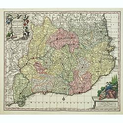
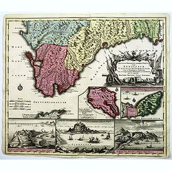
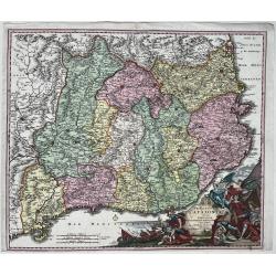
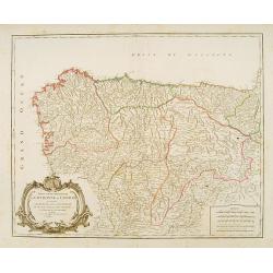
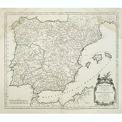
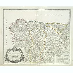
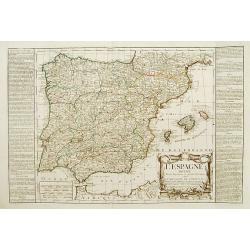
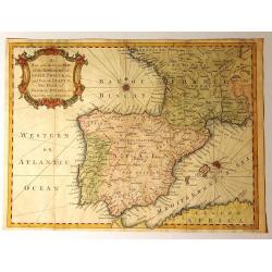
Cataloniae principatus et Ruscionis ae Cerretaniae Comitatuum. . .
Decorative map of Catalonia in southern Spain with a large title cartouche with cherubs and coats of arms.A second state.
Place & Date: Augsburg, 1730
Selling price: $300
Sold in 2012
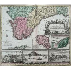
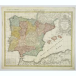
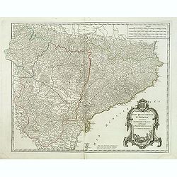
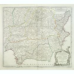
Accurata Designatio Celebris Freti prope Andalusiae Castellum Gibraltar...
Very decorative large-scale map of southern Spain. Shows the area from Cadiz and Jerez to Malaga and Motril in great detail. Includes two inset maps of Minorca and Ceuta,...
Place & Date: Augsburg, 1730
Selling price: $230
Sold in 2016
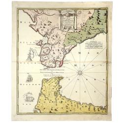
Carte nouvelle de L'ISLE de CADIX & du Detroit de GIBRALTAR.
A decorative map centered on the Strait of Gibraltar. With an inset plan of Gibraltar, decorative title cartouche and four vessels.
Place & Date: Nuremberg, 1730
Selling price: $170
Sold in 2019
![Accurater grundris der […] Spanischen Haupt und Residentz stadt MADRIT. . .](/uploads/cache/48008-250x250.jpg)
Accurater grundris der […] Spanischen Haupt und Residentz stadt MADRIT. . .
An excellent plan of the Spanish capitol of Madrid as it was during the first half of the 18th century by Homann. It is richly decorated by a vignette of the Hermitage St...
Place & Date: Nuremberg, 1730
Carte nouvelle de l'Isle de Cadix & du Detroit de Gibraltar. . .
A wonderful, large scale map of southern Andalusia, Grenada, and the northern tip of Morocco. The map is centered on Gibraltar. The map extends form the mouth of the Guad...
Place & Date: Nuremberg, 1730
Plan de la baye et ville de Cadis, de la rivière de St. Lucas de Barameda, de ses environs.
Beautiful map of the city and bay of Cadiz, engraved by Le Tellier in 1734. Decorated with a title cartridge and several vignettes representing the forts and batteries of...
Place & Date: Paris, 1734
Selling price: $300
Sold in 2017
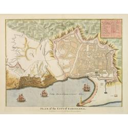
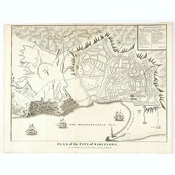
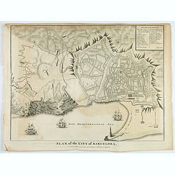
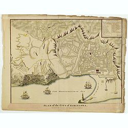
Plan of the City of Barcelona
From Rapin's History of England , a nicely detailed plan of Barcelona, the capital of Catalonia. The plate contains a 19 point legend and the presentation is enhanced wit...
Place & Date: London c.1738
Selling price: $300
Sold
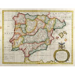
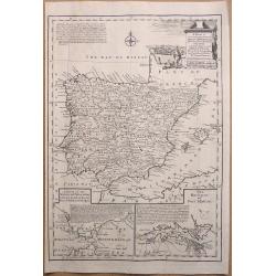
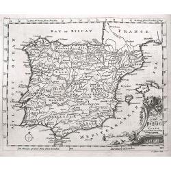
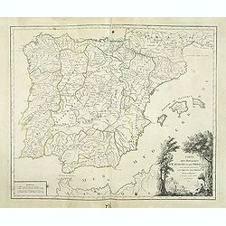
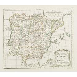
A New Map of Present Spain & Portugal
Decorative colored map of Spain and Portugal with parts of France, the northern part of Africa and the Balearic Islands. From "A New Sett of Maps both of Antient an...
Place & Date: London, 1738
Selling price: $350
Sold in 2012
Plan of the City of Barcelona.
From Rapin's History of England , a nicely detailed plan of Barcelona, the capital of Catalonia. The plate contains a 19 point legend and the presentation is enhanced wit...
Place & Date: London, c.1738
Selling price: $55
Sold in 2020
St. Sebastian. A strong fortified town of Guiapuscoa laying at the bottom of the Bay of Biscay
A very rare plan of San Sebastian in Spain by W.H. TomsThis copper engraved plan of San Sebastian was drawn by G. S. Baudwin and sold, engraved and published by W. H. Tom...
Place & Date: London, 1740
Selling price: $1550
Sold in 2010
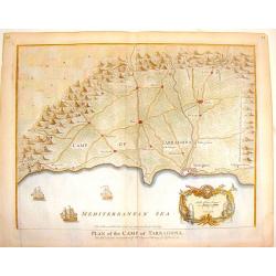
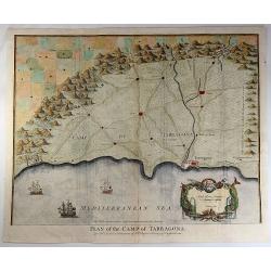
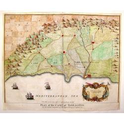
Plan of the Camp of Tarragona.
Interesting battle plan. The cartouche features Neptune and sea serpents and there are three detailed ships at sea. Nicholas Tindal (1687-1774) / Paul de Rapin (1661-172...
Place & Date: London, 1740
Selling price: $28
Sold in 2016
Accurata Designatio Celebris Freti prope Andalusiae Castellum Gibraltar, inter in Europam et Africam, eum circumjacentibus... Portubus, et Castellis cura et impensis. . .
An attractive map by Mattheus Seutter, showing Gibraltar in great detail. With an impressive military style title cartouche, and five beautifully engraved insets of the i...
Place & Date: Augsburg, 1740
Selling price: $220
Sold in 2017
Plan of the Camp of Tarragona.
An interesting map of the Battle of Tarragona in Spain. With a splendid cartouche with Neptune and two sea monsters, and with three detailed ships in the harbour. Paul d...
Place & Date: London, 1740
Selling price: $41
Sold in 2019
Principatus Cataloniae nec non Comitatum Ruscinonensis et Cerretaniae Nova Tabula
Map of the Spanish province of Catalonia and the French provinces Rousillon and Cerdagne. Title in an elaborate cartouche at bottom right among figures, a battle scene, a...
Place & Date: Nuremberg, ca. 1740
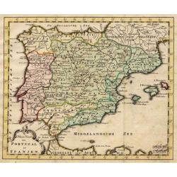
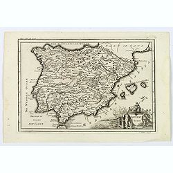
Nieuwe Kaart van Portugal en Spanjen.
A small map of the Iberian peninsula.
Place & Date: Amsterdam/ Deventer, 1742
Selling price: $50
Sold
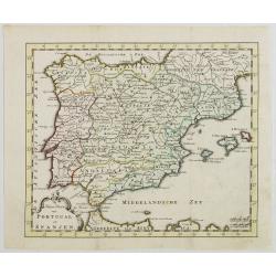
Nieuwe Kaart van Portugal en Spanjen.
Attractive and uncommon map of Spain and Portugal. From Atlas Portatif . RARE.
Place & Date: Amsterdam/ Deventer, 1742
Selling price: $90
Sold in 2008
Plan of the Camp of Tarragona.
Copper engraved map of the Battle of Tarragona in Spain. Slendid cartouche with Neptune and two sea maonsters and with three detailed ships in the harbour. Paul de Rapin...
Place & Date: London, 1743
Selling price: $49
Sold in 2014
Plan of the city of Barcelona.
An interesting copper engraved plan of Barcelona, with ships before the shore, engraved by Basire. Lettered key in upper right corner. Nicholas Tindal (1687-1774) / Paul ...
Place & Date: London, 1743
Selling price: $75
Sold in 2021
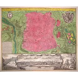
Madritum sive Mantua Carpetanorum celeberrima Castiliae Novae Civitas
A crisply engraved, superbly detailed plan of Madrid. The royal and city arms grace the larger portion of the plate. The lower section provides a prospect of the city, wi...
Place & Date: Nuremberg, ca. 1744
Selling price: $1050
Sold in 2008
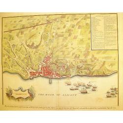
Plan of the city and Castle of Alicant..
A handsome and highly decorative plan of the town of Alicante in south-eastern Spain. The piece contains a 35 point legend along with a cartouche and sailing ships in bat...
Place & Date: London, c. 1745
Selling price: $220
Sold
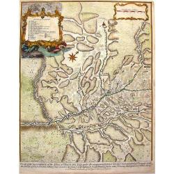
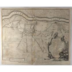
Plan of the Incampment of the Allies at Prats Del Rey.
This large plan of the Encampment at Prat del Rey, Spain, a town approximately 50 Kilometres inland from Barcelona, not far from the modern town of Igualada, in the provi...
Place & Date: London, 1745
Selling price: $65
Sold in 2013
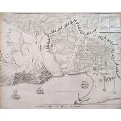
Plan of the City of Barcelona.
From Rapin's History of England , a nicely detailed plan of Barcelona, the capital of Catalonia. The plate contains a 19 point legend and the presentation is enhanced wit...
Place & Date: London, c.1745
Selling price: $100
Sold in 2018
Plan of the City of Barcelona.
Boldly engraved plan of Barcelona. Shows the detailed walled city, surrounded with roads and fields. Numerous fortifications are located, and there is a lettered key (A-X...
Place & Date: London, ca. 1745
Selling price: $110
Sold in 2019
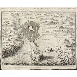
Plan of the Battle of Saragossa.
An original large 18th century copper engraved antique map of the battle of Saragossa or Zaragoza, Aragon, Spain. Fought on Aug 9th 1710 between the troops of the Allies ...
Place & Date: London, 1745
Selling price: $90
Sold in 2019
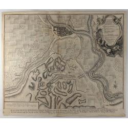
Plan of the Town and Castle of Lerida.
A striking plan of the siege of Lerida by the Bourbon forces under the Duke of Orleans, showing the siege of the town, fortifications, etc. A numbered and lettered key di...
Place & Date: London, 1745
Selling price: $93
Sold in 2019
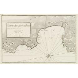
Plan de la Baye de Rose et des Côtes des environs de puis le port de Cadequié jusques au Cap St. Sebastien..
Coastal chart illustrating part of the Spanish Catalan country seacoast. It covers the area from south of Begur to today Cadaqués, close to the French border.From the ra...
Place & Date: Marseille, 1732 - 1746
Selling price: $175
Sold
![[5 charts of Spanish coasts and harbours.] Plan du Port et Rade ... Jacques Ayrouard](/uploads/cache/23140-250x250.jpg)
[5 charts of Spanish coasts and harbours.] Plan du Port et Rade ... Jacques Ayrouard
A set of 5 coastal charts from the rare chart book by Jacques Ayrouard: Recueil de plusieurs Ports ... de la Mer Mediterranie.Plan du Port et Rade de Palamos en Catalogne...
Place & Date: 1732-1746
Selling price: $750
Sold
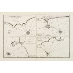
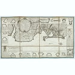
Plan du Passage du Fort Brescon - Plan de la Rade de..
Four charts on one plate : Plan du Passage du Fort Brescon.. - Plan de la Rade de Peniscola en Valence.- Plan de la Rade de Carpi en Valence.- Plan de la Rade de Benidorm...
Place & Date: 1732-1746
Selling price: $100
Sold
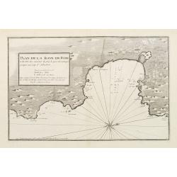
Plan de la Baye de Rose et des Côtes des environs de puis le port de Cadequié jusques au Cap St. Sebastien..
Uncommon chart illustrating part of the Spanish Catalan country seacoast. It covers the area from south of Begur to today Cadaqués, close to the French border.From the r...
Place & Date: Marseille 1732 -1746
Selling price: $425
Sold
![[Untitled Front views of the coastal relief of the Gulf of Valencia as far as Catalonia]](/uploads/cache/23947-250x250.jpg)
[Untitled Front views of the coastal relief of the Gulf of Valencia as far as Catalonia]
Copper engraving presenting separate front views of the southeastern coastal relief of Spain divided in stripes.Covering the area which extends from the Gulf of Valencia ...
Place & Date: Marseille 1732 - 1746
Selling price: $40
Sold
![[Untitled] Front views of the Spanish coastal relief.](/uploads/cache/24838-250x250.jpg)
[Untitled] Front views of the Spanish coastal relief.
Separate front views mainly depicting the coastal relief of Catalonia, divided in stripes.From the rare book by Jacques Ayrouard: Recueil de plusieurs Ports .. de la Mer...
Place & Date: Marseille 1732 - 1746
Selling price: $155
Sold
![[Untitled] Front views of the Spanish coastal relief.](/uploads/cache/28217-250x250.jpg)
[Untitled] Front views of the Spanish coastal relief.
Separate front views depicting great part of the Mediterranean coast of Spain, including Brescon, divided in stripes.It covers the littoral zone between Peñíscola and G...
Place & Date: Marseille, 1732 - 1746
Selling price: $120
Sold in 2010
A New & Accurate Map of Spain & Portugal Drawn from the latest Surveys & most approved Maps & Charts The whole being adjusted by Astron Observations. By Emanuel Bowen
A fine Emanuel Bowen map of Spain and Portugal with two inset plans – ‘The Harbour of Port Mahon’ and ‘A Chart of the Straits of Gibraltar, with the Coast of Spai...
Place & Date: London, 1747
Selling price: $75
Sold in 2017
Antient Spain.
A nice map of Ancient Spain, published in "An Universal History from the Earliest Account of Time to the Present". It shows Spain in Roman times, with Latin spe...
Place & Date: London, 1747
Selling price: $35
Sold in 2019
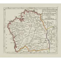
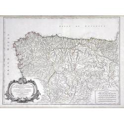
Partie Septentrionale des Etats de Castille où se trouve le Royaume de Gallice..
Detailed map of Galicia, in the northwestern tip of the Iberian Peninsula. From Atlas Portatif Universel, by Robert de Vaugondy.Page 43 outside border top left. Mary Spon...
Place & Date: Paris, later than 1748
Selling price: $105
Sold
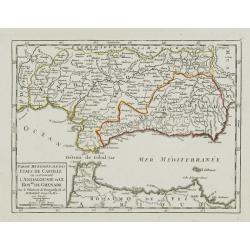
Partie Meridionale des Etats de Castille où se trouvent l'Andalousie et le Roy.me de Grenade.
Small detailed map of Andalusia. From Atlas Portatif Universel, by Robert de Vaugondy.Page 47 outside border top left. Mary Sponberg Pedley does not mention a state witho...
Place & Date: Paris, later than 1749
Selling price: $40
Sold in 2017
Partie Meridion.le des Etats de Castille, où se trouvent l'Estremadure-de-Leon et la Castille Nouvelle.
Small detailed map of Extremadura and New Castile. From Atlas Portatif Universel, by Robert de Vaugondy.Page 45 outside border top left. Mary Sponberg Pedley does not men...
Place & Date: Paris, later than 1749
Selling price: $120
Sold in 2011
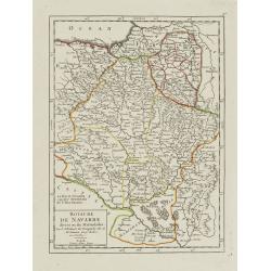
Royaume de Navarre divisé en six Mérindades.
Small detailed map of Navarre. From Atlas Portatif Universel, by Robert de Vaugondy.Page 46 outside border top right. Mary Sponberg Pedley does not mention a state withou...
Place & Date: Paris, later than 1749
Selling price: $120
Sold in 2010
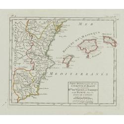
Partie Méridionale de la Couronne d'Aragon.. R.mes de Valence, de Maiorque et de Murcie..
RARE. Small detailed map encompassing the Valencian Community, the region of Murcia and the Balearic Islands.From Atlas Portatif Universel, by Robert de Vaugondy. Page 4 ...
Place & Date: Paris, later than 1749
Selling price: $220
Sold in 2010
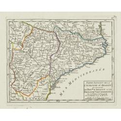
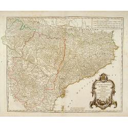
Partie Septent.le de la Couronne d'Aragon où se trouvent le Roy.me d'Aragon.. Catalogne.
Small detailed map of Aragon and Catalonia. From Atlas Portatif Universel, by Robert de Vaugondy.Page 47 outside border top left. Mary Sponberg Pedley does not mention a ...
Place & Date: Paris, later than 1749
Selling price: $85
Sold
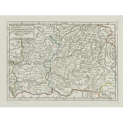
Partie septentrionale de la Couronne de Castille
Detailed map of the north-western part of Spain. Also depicting a small part of southern France.
Place & Date: Paris 1750
Selling price: $112
Sold
Hispania Antiqua.
Map of ancient Spain and Portugal. Engraved by G. Delahaye.
Place & Date: Paris, 1750
Selling price: $30
Sold
Barcelone
Nice small city plan of Barcelona with the fortification walls. With a few ships in the sea.
Place & Date: ca. 1750
Selling price: $100
Sold
Etats de la Couronne d'Aragon?
Detailed map of a province of Spain. Numerous place-names of counties, cities, towns, physical features.
Place & Date: Paris, c.1750
Selling price: $100
Sold
Nieuwe Generale Paskaart van de Bocht van Vrankryk Biscaia en Gallissia tussen I. de Ouessant en C. de Finisterre.
Rare of the Gulf of Biscay including all the south-west coast of France from Brest to the south and continuing along the Spanish coast, including Bilbao, until Ferrol. I...
Place & Date: Amsterdam, ca. 1750
Selling price: $1150
Sold in 2011
Hispania Antiqua.
Map of ancient Spain and Portugal. Engraved by G. Delahaye. From his "Atlas Universel".Gilles Robert de Vaugondy (1688–1766), also known as Le Sieur or Monsie...
Place & Date: Paris, 1750
Selling price: $30
Sold in 2015
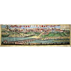
Madrit.
Very rare view of Madrid from Johann Friedrich Probst. Printed on two sheets. Different versions of this exceptional, large view of Madrid were produced by the Probst. No...
Place & Date: Augsburg, ca 1750
Selling price: $890
Sold in 2021
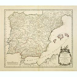
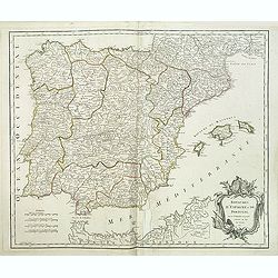
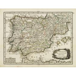
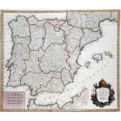
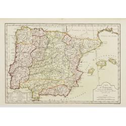
Regnorum Hispaniae et Portugalliae. . .
A beautifully detailed map of Spain and Portugal by Homann. It offers excellent detail of the Iberian Peninsula and the Balearic Islands, plus parts of southwestern Franc...
Place & Date: Nuremberg, ca 1750
Selling price: $66
Sold in 2021
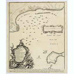
Draught of the Bay of Bulls between the Town of Rotta and Fort St. Catherine. . .
A large plan of the Bay of Bulls in southern Spain, outlining a military action fought by the English there, as part of the ongoing 'War of the Spanish Succession' - foug...
Place & Date: London, ca 1751
Selling price: $40
Sold in 2020
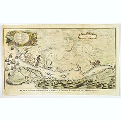
Plan of the Town and Harbour of mahon, St. Philip's Castle, and its Fortifications.
An attractive bird's-eye plan of Mahon and its fortifications and surrounds in the mid eighteenth century. You see the town plan of Mahon, the capitol of the Balearic isl...
Place & Date: London, 1751
Selling price: $100
Sold in 2019
Partie Septentrionale de la Couronne de Castille ou se trouvent Les Royaumes de Castille Vieille de Leon, de Gallice, des Asturies, La Biscaye et la Navarre...
Highly detailed map of Northwestern Spain, including the regions of Gallicia, Leon, Asturias, Castille and Biscaya by Robert de Vaugondy. In the southern portion of the m...
Place & Date: Paris, 1752
Selling price: $110
Sold in 2010
Royaumes d'Espagne et de Portugal.
Detailed map of Spain, Portugal and Baleares islands. Showing also south part of Franc and north Africa from his "Atlas Universel".Gilles Robert de Vaugondy (16...
Place & Date: Paris, 1752
Selling price: $60
Sold in 2015
Partie septentrionale de la Couronne de Castille.
Detailed map of the northern part of Spain. Also depicting a small part of northern Portugal from his "Atlas Universel." Gilles Robert de Vaugondy (1688–1766)...
Place & Date: Paris, 1752
Selling price: $80
Sold in 2011
Etats de la Couronne d'Aragon. . .
Decorative map of the Kingdom of Aragon, with cartouche and coat of arms. Numerous place-names of counties, cities, towns, physical features from his "Atlas Universe...
Place & Date: Paris, 1752
Selling price: $36
Sold in 2015
Spain and Portugal.
A small interesting copper engraved map of the Iberian peninsula. It names many towns, rivers, and includes the Balearic Islands. Extends to show also Tanger and Ceuta.De...
Place & Date: London, ca 1754
Selling price: $32
Sold in 2018
L' Espagne Suivant les Nouvelles Observations.
Fine map of Spain and Portugal with decorative title cartouche. With date 1743 added in manuscript.George Louis Le Rouge was active from 1740- till 1780 as a publisher, a...
Place & Date: Paris 1756
Selling price: $60
Sold

Veduta della Citta di Siviglia../ ..Eglise de Seville.
Fine panoramic view of the Sevillia. Taken from Storia moderna di tutti I popoli del mondo , edited by Thomas Salmon. A italian edition of this famous work, published in ...
Place & Date: Venice 1740-1756
Selling price: $65
Sold
L'Espagne divisée en ses Royaumes et .. avac le Royaumes de Portugal.
RARE map of Spain and Portugal prepared by J.B.Nolin and published by Daumont. A visually stunning map with a large title cartouche. To the left and right text boxes with...
Place & Date: Paris 1757
Selling price: $250
Sold
Partie Meridionale des Etats de Castille où se trouvent l'Andalousie et le Roy.me de Grenade.
Decorative and highly detailed map of Southwestern Spain and including a decorative cartouche from his "Atlas Universel".Gilles Robert de Vaugondy (1688–1766)...
Place & Date: Paris, 1757
Selling price: $50
Sold in 2011
Carte des Royaumes d'Espagne et de Portugal.
Detailed map of Spain, Portugal and Baleares islands. Showing also southwestern part of France and north Africa from his "Atlas Universel".Gilles Robert de Vaug...
Place & Date: Paris, 1757
Selling price: $30
Sold in 2019
LOS REYNOS DE ESPANA Y PORTUGAL...
A nice example of Gendron's map of the Iberian Peninsula. As most 18th Century maps published in Spain, which are based upon non-Spanish sources, are based upon French so...
Place & Date: Madrid, 1757
Selling price: $200
Sold in 2021
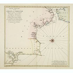
Nieuwe zeekaart van de Straat van Gibraltar..
Decorative map of Gibraltar and the coast of the Algarve (Portugal) till Lisbon. Including northern most tip of Morocco, including towns of Tangier, Ceuta and Tetuan.East...
Place & Date: Amsterdam, 1759
Selling price: $100
Sold in 2017
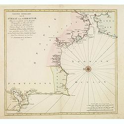
Nieuwe zeekaart van de Straat van Gibraltar. . .
Decorative map of Gibraltar and the coast of the Algarve (Portugal) till Lisbon. Including northern most tip of Morocco, including towns of Tangier, Ceuta and Tetuan.East...
Place & Date: Amsterdam, 1759
Selling price: $65
Sold in 2013
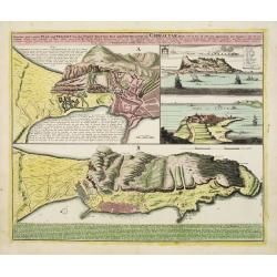
Neuester und exacter Plan .. von Gibraltar..
Scarce decorative plan of Gibraltar with fine views of the mount and Cidix. With a numbered key to the principal places in town.
Place & Date: Nuremberg 1760
Selling price: $230
Sold
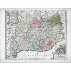
Cataloniae Principatus et Ruscinonis ae Cerretaniae Comitatuum exactissima Delineatio, Cura et Studio. . .
Beautifully colored map of the Catalonia region of northeastern Spain by Tobias Conrad Lotter. The cities of Barcelona, Tortosa, Tarragona are depicted along the Mediterr...
Place & Date: Augsburg, c.1760
Selling price: $200
Sold in 2010
A New and Accurate Map of the Kingdoms of Spain, Portugal and Part of France, The Islands of Majorca, Minorca &c.
Poduced for “Universal Magazine” by J. Hinton. It was engraved by Richard William Seale (1703-1762). The map features an attractive rococo cartouche and compass rose...
Place & Date: London, ca. 1760
Selling price: $115
Sold in 2018

Attaque de deux bastions les breches faites par le mineur.
Optical view. Reversed title. Print of Barcelona’s siege in 1714. (From Hyacinthe Rigaud). Ink annotations in the margins.
Place & Date: Augsburg, ca. 1760
Selling price: $100
Sold in 2020
Carte du Detroit de Gibraltar Dressée au Depost des Cartes et Plans de la Marine pour le service des Vaisseaux du Roy par Ordre de M. le Duc de Choiseul Ministre de la Guerre et de la Marine. . . N° 35
A very detailed chart prepared by J.N. Bellin of the Straits of Gibraltar locating harbors and bays and coastal soundings. Decorative title cartouche. Depicts Cape Trafal...
Place & Date: Paris, 1761
Selling price: $700
Sold in 2009
Carte Hydrographique de la Baye de Cadix..
A large and very handsome chart of the Bay of Cadiz, from the town of Rota to Cadiz. The piece contains dramatic coastal topography, forts, anchorages and soundings. Beau...
Place & Date: Paris, 1762
Selling price: $360
Sold
Royaumes d'Espagne et de Portugal.
Detailed map of Spain, Portugal and Baleares islands. Showing also southwestern part of France and north Africa.
Place & Date: Paris, 1762
Selling price: $40
Sold
Carte hydrographique de la Baye de Cadix. . .
Uncommon of Cadiz and surroundings.Jacques Nicolaas Bellin (1703-1772) was one of the most important and proficient French cartographers of the mid-eighteenth century. H...
Place & Date: Paris, 1762
Selling price: $120
Sold in 2011
Carte Hydrographique de la Baye de Cadix : Dressée au Dépost des Cartes et Plans de la Marine pour le Service des Vaisseaux du Roy / Par ordre de M. le duc de Choiseul. . .
Scarce of Cadiz and surroundings prepared by Étienne-François de Choiseul (1719-1785).Jacques Nicolaas Bellin (1703-1772) was one of the most important and proficient ...
Place & Date: Paris, 1762
Selling price: $200
Sold in 2017

Vue Perspective d'un Jeu de Bague en Espagne.
Optical vue of children playing in Spain. In the eighteenth and nineteenth centuries there were many popular specialty establishments in Paris, Augsburg and London, that ...
Place & Date: Paris, 1762
Selling price: $17
Sold in 2019
Carte d'Espagne, Dirigée par Mr. Philippe..
Detailed map of the Hibernian Peninsula and Baleares islands, showing a short legend in the lower left corner.
Place & Date: Paris, 1763
Selling price: $30
Sold
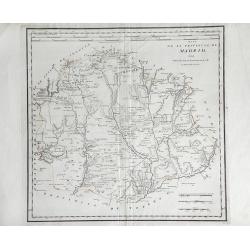
Mapa de La Provincia, de Madrid. . .
Detailed of the region surrounding the city of Madrid, Spain, by Thomas Lopez. Shows the rivers, forests and mountains of the region.
Place & Date: Madrid, 1763
Selling price: $125
Sold in 2010