Browse Listings in Europe > Scandinavia > general
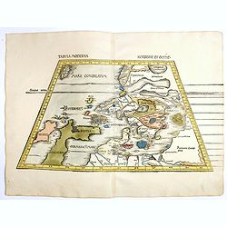
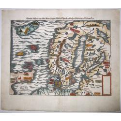
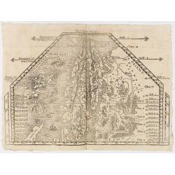
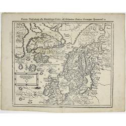
Tabula Moderna Norbegie et Gottie.
Rare woodblock map of Scandinavia published by Waldseemüller, from the first modern atlas, because the 20 new maps in this atlas show all parts of the world based on con...
Place & Date: Strasbourg, Johann Schott, 1513-1520
Selling price: $6000
Sold in 2020
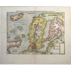
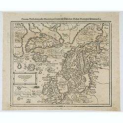
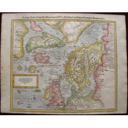
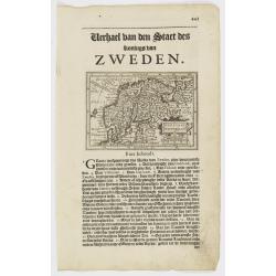
Gemeine Beschreibung Aller Mitnachtigen Lander Schweden, Gothen, Nordwegien, Dennmarck &c.
One of the earliest woodcut maps of Scandinavia. Shows Iceland, Norway, Sweden, Finland, Scotland, Denmark with the North Sea and Baltic Sea. Sebastian Munster's second m...
Place & Date: Basel, ca 1540
Selling price: $325
Sold in 2019
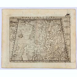
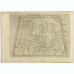
Sconladia Nova.
Gastaldi's modern map of Scandinavia, Iceland, and the Baltic According to Bill Ginsberg the map was "built upon previous publications, in particular, the representa...
Place & Date: Venice, 1548
Selling price: $1100
Sold in 2022
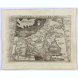
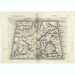
Tabula Europae VIII. (Russia, Ukraine, Baltic, Scandinavia)
Gastaldi's map showing the Baltic in the North and the Black Sea in the south. Based upon Ptolemy.Embellished is a sailing ship, sea monster and several curious animals.I...
Place & Date: Venice, 1548
Selling price: $325
Sold in 2022
Gemeine beschreibung aller Mitnaechtigen Laender, Schweden, Gothen, Nordwegien, Dennmarck, sc.
An early Sebastian Münster's woodcut map of Scandinavia, based on the 'Carta Marina' of Olaus Magnus, 1539. The map includes Norway, Sweden, Finland, Denmark, Iceland, S...
Place & Date: Basel, ca 1550
Selling price: $550
Sold in 2020
![[Lot of 19 leaves of Scandinavia, Greenland, Island]](/uploads/cache/48298-250x250.jpg)
[Lot of 19 leaves of Scandinavia, Greenland, Island]
Nineteen text leaves illustrated with wood block prints and maps relating to Scandinavia, Greenland and Island. From the 1552 Latin text edition of Münster's Cosmographi...
Place & Date: Basel, 1552
Selling price: $155
Sold in 2022
Gemeine beschreibung aller Mitnaechtigen Laender, Schweden, Gothen, Nordwegien, Dennmarck, sc.
An early Sebastian Münster's woodcut map of Scandinavia, based on the 'Carta Marina' of Olaus Magnus, 1539. The map includes Norway, Sweden, Finland, Denmark, Iceland, S...
Place & Date: Basel, 1560
Selling price: $300
Sold in 2021
Schonladia Nuova.
Depicting Scandinavia in a trapezoidal projection, being one of the earliest obtainable modern maps of Scandinavia. The map combines Ptolemaic and modern cartographic inf...
Place & Date: Venice, 1561
Selling price: $200
Sold in 2017
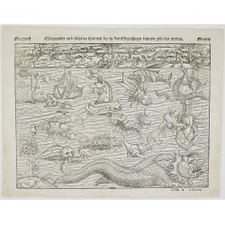
Mörewunder vnd seltzame thier
Spectacular woodcut of mythical land with sea monsters and animals. The monsters were first engraved in the ‘Carta Marina’ of 1539 by Olaus Magnus and have been us...
Place & Date: Basel, 1561
Selling price: $1500
Sold in 2022
![[Southern Scandinavia to central Germany, Netherlands and East England]](/uploads/cache/25014-250x250.jpg)
[Southern Scandinavia to central Germany, Netherlands and East England]
The rare second state is dated 1562, but still lacks the imprint of Camocio. The map has no title and extends from Southern Scandinavia to Central Germany, The Netherland...
Place & Date: Venice, 1562
Selling price: $21200
Sold
(SCANDINAVIE). Monogr. THW (Thomas Weber) dated 1567.
Rare and important map of Scandinavia from Olaus Magnus' Historia Olai Magni gothi archiepiscop upsalensis, de gentium septentrionalium, published in Basel in 1567.The ma...
Place & Date: Basle, 1567
Selling price: $7000
Sold in 2019
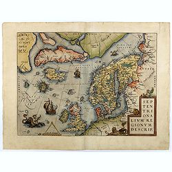
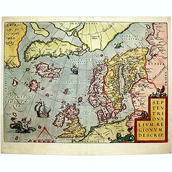
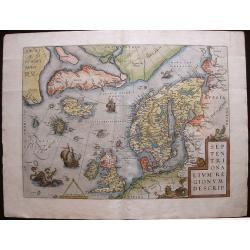
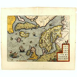
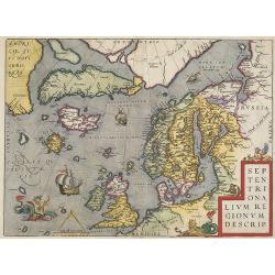
Septentrionalium Regionum Descrip.
Early second state of this influential map of the Arctic, including Scandinavia, Iceland, Greenland and part of the North American continent, includes also the legendary ...
Place & Date: Antwerp, 1571/1573
Selling price: $1750
Sold in 2018
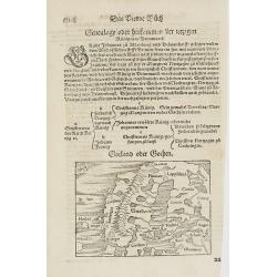
Gotland oder Gothen.
Map of Scandinavia. From his Cosmographia, that great compendium of Renaissance knowledge. An exciting print.Sebastian Münster was born in Nierder-Ingelheim, near Mainz ...
Place & Date: Basle 1550-1580
Selling price: $70
Sold in 2010
![[Map of Scandinavia]](/uploads/cache/91426-250x250.jpg)
[Map of Scandinavia]
Small Scandanvia woodcut map by Sebastian Münster.
Place & Date: Basel, c. 1580
Selling price: $55
Sold in 2010
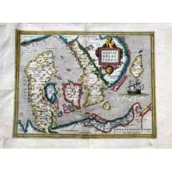
Daniae regni typus.
A very decorative, and nicely colored example of Ortelius' map of Denmark, extending from Schleswig Holstein and Mechlenberg, Pomerania and Prussian coasts to the Norwegi...
Place & Date: Antwerp, ca 1580
Selling price: $310
Sold in 2020
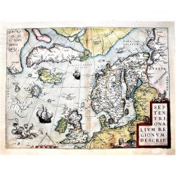
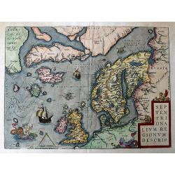
Septentrionalium Regionum Descrip.
This influential map of the Arctic, including Scandinavia, Iceland, Greenland and part of the North American continent, includes also the legendary islands of i.a. Drogeo...
Place & Date: Antwerp, 1584
Selling price: $1950
Sold in 2014
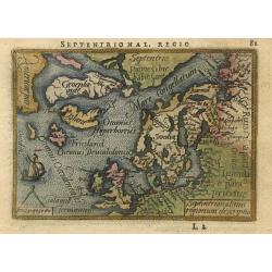
Septentrionalium regionum descriptio
Handsome miniature map based on Ortelius' important map of the Arctic regions with the mythical islands of Drogeo and Frieslant. The map is beautifully engraved with stip...
Place & Date: Antwerp, 1588
Selling price: $260
Sold
Gemeine Beschreibung aller Mitnachtigen Lander/ alsz Schweden / Gothen / Norwegien / Dennmark &c
Interesting wood block printed map of Europe, Scandinavia, England, Denmark, Norway, Sweden, Iceland, The Baltics, Greenland, and America.The map shows two Greenlands, on...
Place & Date: Basle, 1588
Selling price: $950
Sold in 2014
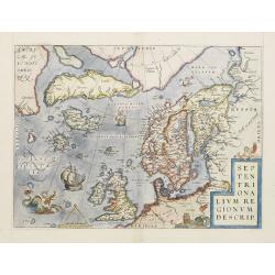
Septentrionalium Regionum Descrip.
Influential map of the Arctic. It includes Scandinavia, Iceland, Greenland and part of the North American continent, together with the legendary islands of the north: Dro...
Place & Date: Antwerp, ca. 1590
Selling price: $1200
Sold in 2015
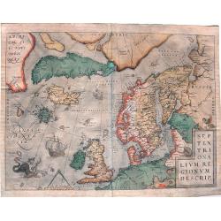
Septentrionalium Regionum Descrip.
A fascinating and important map of the North Atlantic by A. Ortelius in beautiful original colors.
Place & Date: Antwerp, 1590
Selling price: $1400
Sold in 2016
Septentrionalium Regionum Descrip.
An influential map of the Arctic. It includes Scandinavia, Iceland, Greenland and part of the North American continent, together with the legendary islands of the north: ...
Place & Date: Antwerp, 1590
Selling price: $850
Sold in 2018
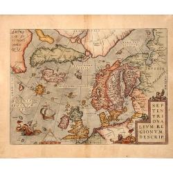
Septentrionalium Regionum Descrip.
This influential map of the Arctic, including Scandinavia, Iceland, Greenland and part of the North American continent, includes also the legendary islands of i.a. Drogeo...
Place & Date: Antwerp 1598
Selling price: $1800
Sold
SEPTENTRIONALIUM REGIONUM DESCRIP, 1598
A copperplate full colored decorative map of North Europe.This influential map of the Arctic, including Scandinavia, Iceland, Greenland and part of the North American con...
Place & Date: Antwerp, 1598
Selling price: $950
Sold in 2019
Europae Tabula VIII.
The third state of Ruscelli's map of Eastern Europe and Scandinavia, based upon Claudius Ptolemy. Showing "Daniae et Norvegiae" as an island, with a separate is...
Place & Date: Venice, 1598
Selling price: $175
Sold in 2018
Septentrionalium Regionum Descrip.
This influential map of the Arctic, including Scandinavia, Iceland, Greenland and part of the North American continent, includes also the legendary islands of i.a. Drogeo...
Place & Date: Antwerp, 1598
Selling price: $1750
Sold in 2018
Gemeine Beschreibung aller Mitnachtigen Lander / alss Schweden / Gothen / Norwegien / Denmarck / &c.
Sebastian Münster’s third and final map of Scandinavia including England, Denmark, Norway, Sweden, Iceland, The Baltics, Greenland and America by Sebastian Munster 159...
Place & Date: Basle, 1598
Selling price: $700
Sold in 2019
Septentrionalium Regionum Descrip.
A fantastic map of the northern Atlantic. Shows a part of America, Greenland, Iceland, the British Islands, Scandinavia, and parts of Europe and Russia. With several phan...
Place & Date: Antwerp, 1601
Selling price: $1500
Sold in 2016
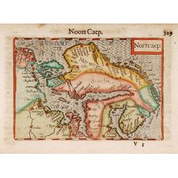
Nortcaep
A beautifully engraved early 17th century map of Scandinavia, west to the top. With lovely hand color.
Place & Date: Amsterdam 1606
Selling price: $200
Sold
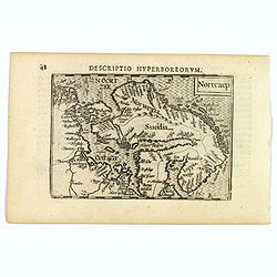
Nortcaep.
A lovely miniature map of Scandinavia, published by Petrus Bertius, in Amsterdam at the beginning of the seventeenth century.North is orientated to the right. The sea is ...
Place & Date: Amsterdam, 1606
Selling price: $140
Sold in 2019
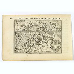
Description Norwegiae et Sveciae.
An attractive miniature map of Sweden and Norway, and northern Europe by Petrus Bertius, published in Amsterdam at the beginning of the seventeenth century. Apart from Sc...
Place & Date: Amsterdam, 1606
Selling price: $80
Sold in 2019
Svecia, et Norwegia etc.
Map of Scandinavia, decorated with a small strap work title cartouche. From the first French-text edition of Jodocus Hondius' Atlas Minor.Shortly after the publication of...
Place & Date: Amsterdam, 1608
Selling price: $150
Sold in 2009
Septentrionalium Regionum Descrip.
From the very rare Italian text edition. This influential map of the Arctic, including Scandinavia, Iceland, Greenland and part of the North American continent, includes ...
Place & Date: Antwerp, 1608
Selling price: $2650
Sold in 2009
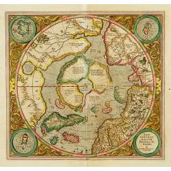
SEPTENTRIONALIUM Terrarum descriptio. Per Gerardum Mercatore
State 2. This is the first map devoted to the Arctic, a hemispherical one on a North Polar projection with an attractive floral design surrounding it. In the corners are ...
Place & Date: Amsterdam 1609
Selling price: $2400
Sold
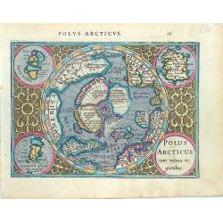
Polus Arcticus cum vicinis regionibus.
Early map of the North Polar regions. Shows the mythical land masses near the pole, the clearly navigable NW and NE passages, a massive California and marvelous detail in...
Place & Date: Amsterdam, 1610
Selling price: $450
Sold in 2014
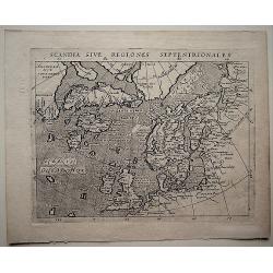
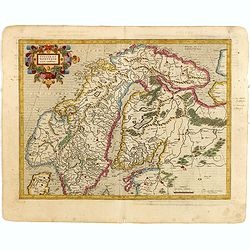
Scandia Sive Regionies Septentrionales.
A detailed map of Scandinavia with Greenland, parts of the North Pole and North America by Magini (1555-1617), from 'Geographiae, tum veteris, tum novae, volumina duo., p...
Place & Date: Arnhem, 1617
Selling price: $165
Sold in 2018
Suecia et Norvegia ect.
Small map of Scandinavia, surrounded by text in Dutch. On verso a copperplate engraving on text leaf depicting a half length oval portrait of "Gustavus D G Sveciae G...
Place & Date: Amsterdam, Cloppenburch, 1621
Selling price: $300
Sold
Suecia et Norvegia cum confiniis.
One of the oldest foreign maps of Scandinavia was designed by Lieven Algoet, a poet, calligrapher and cartographer from Ghent, who died in 1547. Mercator's map has the sa...
Place & Date: Amsterdam, 1630
Selling price: $170
Sold in 2015
![[Lot of 3 maps of the Ukrainia] Taurica Chersonesus, Nostra aetate Przecopsca, et](/uploads/cache/20721-(1)-250x250.jpg)
[Lot of 3 maps of the Ukrainia] Taurica Chersonesus, Nostra aetate Przecopsca, et
[Lot of 3 maps of the Ukrainia]- Tavrica Chersonesus, Nostra Aetate Przecopsca, Et Gazara Dictur. (W.Blaeu) 1642 - Taurica Chersonesus. (la presqu'ile ou chersonese p...
Place & Date: Amsterdam, c. 1635
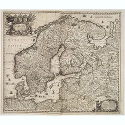
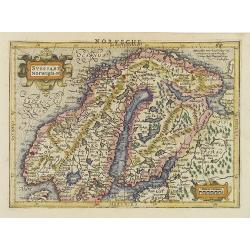
Sueciae, Norvegiae et Daniae Nova Tabula.
Signed lower right. A decorative map of the whole of Scandinavia with a large title cartouche and a decorative scale cartouche, and many ships in the seas and little figu...
Place & Date: Amsterdam, 1640
Selling price: $300
Sold in 2020
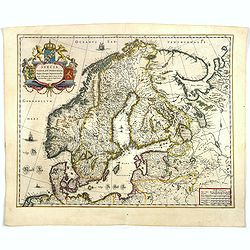
Svecia, Dania, et Norvegia regnae Europe septentrionale.
Famous map of Scandinavia, copied from the wall map (1620) by the Swedish cartographer Andreas Bure (1571-1646).More about Willem Blaeu. [+]
Place & Date: Amsterdam, 1644
Selling price: $600
Sold in 2017