Browse Listings in Europe > Scandinavia
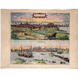
Hafnia vulgo Kopenhagen. (Copenhagen)
Two views of Copenhagen, by Georg Braun & Frans Hogenberg.
Place & Date: Cologne, 1588
Selling price: $350
Sold in 2020
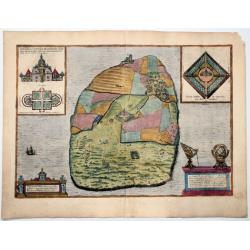
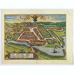
Topographia insulae Hvenae in celebri porthmo regni Daniae, quem vulgo oersunt vocant : effigiata Coloniae 1586 (Hven/Uraniborg - Tycho Brahe)
An antique map showing Uraniborg, which was a Danish astronomical observatory and alchemy laboratory established and operated by Tycho Brahe. It was built c. 15...
Place & Date: Cologne, 1588
Selling price: $625
Sold in 2020
![Helsheborch [on sheet with] Lunden [and] Elbogen [and] Landeskron. (Helsingborg, Lund, Malmö, Landskrona)](/uploads/cache/84389-250x250.jpg)
Helsheborch [on sheet with] Lunden [and] Elbogen [and] Landeskron. (Helsingborg, Lund, Malmö, Landskrona)
Four bird's-eye views of Swedish towns by Braun and Hogenberg : Helsingborg, Lund, Malmö and Landskrona.HELSINGBORG with COMMENTARY BY BRAUN (on verso): "Helsingbor...
Place & Date: Cologne, 1588
Selling price: $1450
Sold in 2020
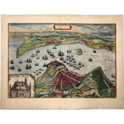
Freti Danici or Sundt Accuratiss Delineatio.
Bird's-eye view of The Sound with Helsingborg, Landskrona and Elbogen, by Georg Braun and Frans Hogenberg. Inset with a view of Kronenborg Castle.Translation of cartouche...
Place & Date: Cologne, 1588
Selling price: $600
Sold in 2020
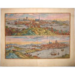
STOCKHOLM - STOCHOLM.
An old, antique map with two bird's-eye/panoramic views(North and South) of Stockholm, by Georg Braun and Frans Hogenberg, after Hieronymus Scholäus. Showing its active ...
Place & Date: Cologne, 1588
Selling price: $1300
Sold in 2021
![Danorum Marca, uel Cimbricum. aut Daniae Regnum. . .[DENMARK]](/uploads/cache/84987-250x250.jpg)
Danorum Marca, uel Cimbricum. aut Daniae Regnum. . .[DENMARK]
The oldest preserved map of Denmark of Danish origin. Drawn by Marcus Jordan at the request of Duke Heinrich Rantzau, viceroy of Schleswig-Holstein. It is a new perceptio...
Place & Date: Cologne, 1588
Selling price: $1850
Sold in 2021
Colding Schloss und Stat.
A bird's eye view of Kolding castle and town from Braun & Hogenberg. The port of Kolding on the Danish Jutland Peninsula is seen in cavalier perspective from the sout...
Place & Date: Cologne, 1589
Selling price: $190
Sold in 2019
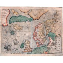
Septentrionalium Regionum Descrip.
Influential map of the Arctic. It includes Scandinavia, Iceland, Greenland and part of the North American continent, together with the legendary islands of the north: Dro...
Place & Date: Antwerp, ca. 1590
Selling price: $1200
Sold in 2015
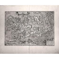
Islandia.
Probably the most famous (and among the most beautiful!) map of Iceland. On the south side an impressive collection of sea monsters. Polar bears on ice flows and volcanoe...
Place & Date: Anwerp, ca 1590
Selling price: $4200
Sold in 2016
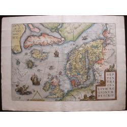
Septentrionalium Regionum Descrip.
A fascinating and important map of the North Atlantic by A. Ortelius in beautiful original colors.
Place & Date: Antwerp, 1590
Selling price: $1400
Sold in 2016