Browse Listings in Europe > Scandinavia
![Hafnia Metropolis et Portus Celeberrimus Daniae. [Coppenhagen]](/uploads/cache/82076-250x250.jpg)
Hafnia Metropolis et Portus Celeberrimus Daniae. [Coppenhagen]
A striking birds-eye view of Copenhagen, from Merian's Neuwe Archontologica Cosmica . . ., published in 1638. It shows town, buildings, churches, harbour, bridges, ships,...
Place & Date: Frankfurt, 1638
Selling price: $110
Sold in 2018
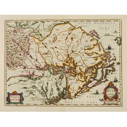
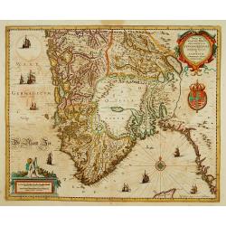
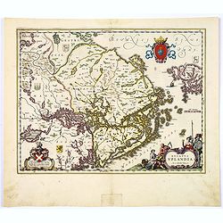
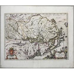
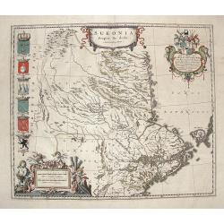
Uplandia.
Covers the area of the modern Uppsala, the vicinity of Stockholm, and includes most of Aland.
Place & Date: Amsterdam, 1639
Selling price: $400
Sold in 2012
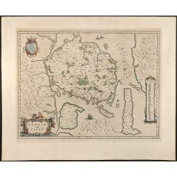
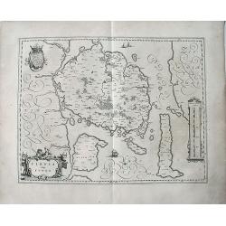
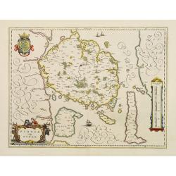
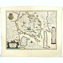
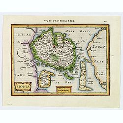
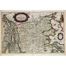
Fionia vulgo Funen
Beautiful old colored map of Funen in Denmark from J. Blaeu. Showing Funen, Als and Langeland. With one colored cartouche and scale.
Place & Date: Amsterdam, 1640
Selling price: $160
Sold in 2009
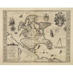
Nova famigerabilis insulae ac ducatus Rugiae descriptio.
Both side borders are filled with coat of arms of the island's leading families. Including two compass roses, sailing ships, sea monsters and a large coat of arms in the ...
Place & Date: Amsterdam, c.1640
Selling price: $100
Sold in 2011
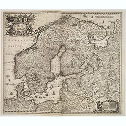
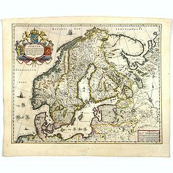
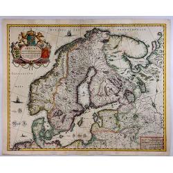
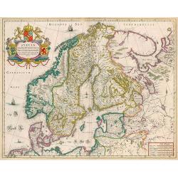
Sueciae, Norvegiae et Daniae Nova Tabula.
Signed lower right. A decorative map of the whole of Scandinavia with a large title cartouche and a decorative scale cartouche, and many ships in the seas and little figu...
Place & Date: Amsterdam, 1640
Selling price: $300
Sold in 2020
Fionia vulgo Funen.
A very decorative, large map of Funen in Denmark from J. Blaeu. Depicted are Funen, Als and Langeland. With one decorative cartouche and scale.
Place & Date: Amsterdam, 1640
Selling price: $100
Sold in 2023
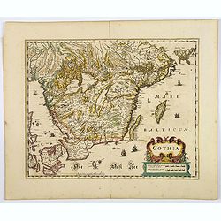
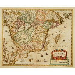
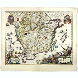
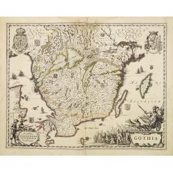
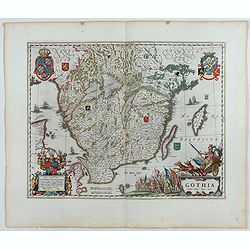
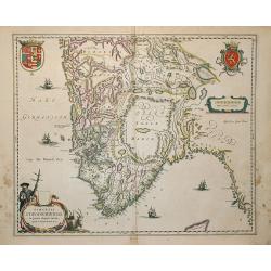
Gothia.
An attractive map of southern part of Sweden including Stockholm, Uppsala, Gothenburg, Malmö. But also Copenhagen and Oslo. A decorative title cartouche and a number of ...
Place & Date: Amsterdam, ca 1640
Selling price: $200
Sold in 2020
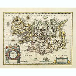
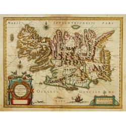
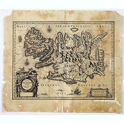
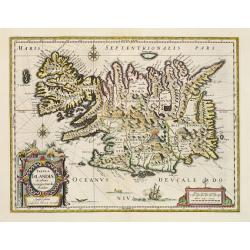
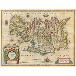
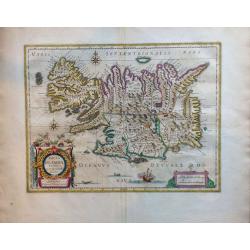
Tabula Islandiae.
A fine map of Iceland. Very attractive title cartouche in the lower left corner: around the island, a ship and two sea monsters are depicted.In spite of it's restorations...
Place & Date: Amsterdam 1641
Selling price: $1080
Sold in 2016
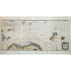
Tabula Portuum Occidentalium Norwegiae et Spizbergi.
Copper engraving sea chart, printed from 2 plates, by M. Merian from J. A. à Werdenhagen, "De rebus publicis Hanseaticis tractatus". Very decorative cartouche.
Place & Date: Frankfurt, 1641
Selling price: $225
Sold in 2018
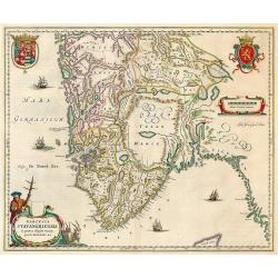
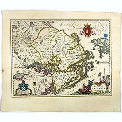
Nova ..Stavangriensis, Bergensis et Asloiensis..
Fine map of the southern part of Norway. Decorated with many ships and a compass rose.
Place & Date: Amsterdam 1639-1644
Selling price: $300
Sold
Gothia.
Southern part of Sweden including Stockholm, Uppsala, Gothenburg, Malmö. But also Copenhagen and Oslo.
Place & Date: Amsterdam 1639-1644
Selling price: $300
Sold
Tabula Islandiae..
Early imprint before Blaeu bought the copper plate for his atlas. Prepared by Georgio Carolo Flandrio. The map has a very decorative cartouche. Very fine imprint.
Place & Date: Amsterdam, 1639-1644
Selling price: $550
Sold
Fionia vulgo Funen
Fine map of Fyn, Langeland and Alsen decorated with three cartouches and a sailing ships.
Place & Date: Amsterdam 1644
Selling price: $130
Sold
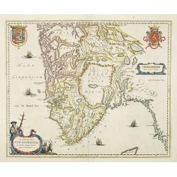
Dioecesis Stavangriensis.
Stavanger by Blaeu. Latin text on verso.
Place & Date: Amsterdam, 1640-1644
Selling price: $285
Sold in 2009
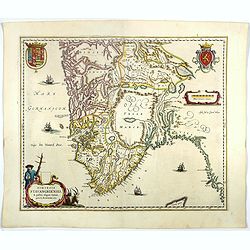
Dioecensis Stavangriensis, Apud Joh. et Cornel. Blaeu.
Fine decorative map of southern Norway from 61 deg. N. Oslo, Stavanger and Bergen prominently shown. The map presents a vivid view of the fjords and mountains topography ...
Place & Date: Amsterdam, 1644
Selling price: $600
Sold
Dioecensis Stavangriensis..
Fine decorative map of southern Norway from 61 deg. N. Oslo, Stavanger and Bergen prominently shown. The map presents a vivid view of the fjords and mountains topography ...
Place & Date: Amsterdam, 1644
Selling price: $325
Sold in 2018
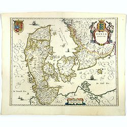
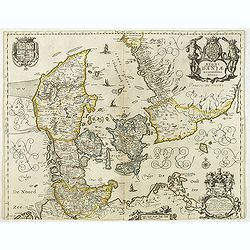
Dania Regnum.
Standard map of Denmark with fine title cartouche and coat of arms.More about Willem Blaeu. [+]
Place & Date: Amsterdam, 1644
Selling price: $240
Sold in 2018
Fionia vulgo Funen
Fine map of Fyn, Langeland and Alsen decorated with three cartouches and a sailing ships. More about Willem Blaeu. [+]
Place & Date: Amsterdam, 1644
Selling price: $100
Sold in 2021
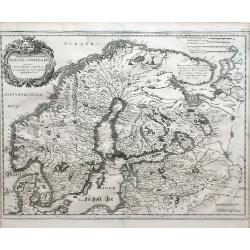
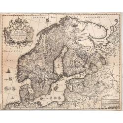
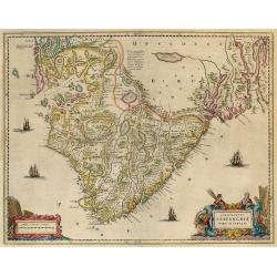
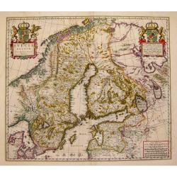
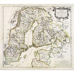
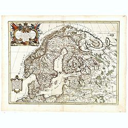
Svecia, Dania, et Norvegia regnae Europe septentrionale.
Famous map of Scandinavia, copied from the wall map (1620) by the Swedish cartographer Andreas Bure (1571-1646).More about Willem Blaeu. [+]
Place & Date: Amsterdam, 1644
Selling price: $600
Sold in 2017
Gothia.
Very decorative map of the southern part of Sweden. The forested topography and lakes are well depicted.The main feature of the engraving is the large title cartouche sur...
Place & Date: Amsterdam, 1644
Selling price: $275
Sold in 2017
Ducatus Uplandia.
Nice map of Central Sweden around Stockholm with a decorative cartouche. More about Willem Blaeu. [+]
Place & Date: Amsterdam, 1644
Selling price: $250
Sold in 2018
Tabula Islandiae. . .
Prepared by Georgio Carolo Flandrio. The map has a very decorative cartouche, and a very fine imprint.
Place & Date: Amsterdam, 1639-1644
Selling price: $100
Sold in 2017
Ducatus Uplandia.
A beautifully engraved and executed map of the area of the modern Uppsala land in the vicinity of Stockholm, and includes most of Aland by Blaeu. With a Swedish coat of a...
Place & Date: Amsterdam, ca. 1644
Selling price: $165
Sold in 2018
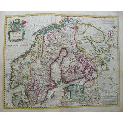
Svecia, Dania et Norvegia, Regna Europa Septentrionalia.
A striking map of the kingdoms of Sweden, Denmark and Norway (Scandinavia), attributed to Anders Bure (1571-1646), a Swedish cartographer and mathematician. Bure, also kn...
Place & Date: Amsterdam, 1644
Selling price: $500
Sold in 2018
Gothia.
Very decorative map of the southern part of Sweden. The forested topography and lakes are well depicted.The main feature of the engraving is the large title cartouche sur...
Place & Date: Amsterdam 1645
Selling price: $100
Sold
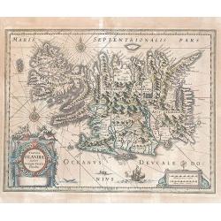
Tabula Islandiae..
This handsome map of Iceland was based on information from a Dutch navigator named Joris Carolus in about 1620. The map shows the influence of both versions of bishop Gud...
Place & Date: Amsterdam 1645
Selling price: $475
Sold
Tabula Islandiae.
Based on information from Joris Carolus collected around 1620. Huge mountains and volcanoes in a labyrinth of fiords. It is embellished by title and distance cartouches, ...
Place & Date: Amsterdam, 1645
Selling price: $350
Sold in 2017
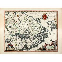
Ducatus Uplandia. Joh. et Cornelius Blaeu exc
Original old colored map of central Sweden showing the area around Stockholm. With a Swedish coat of arms, a figural cartouche with rural people and a knight in amour, a ...
Place & Date: Amsterdam, 1645
Selling price: $500
Sold in 2009
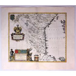
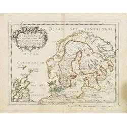
Suecia, Dania et Norvegia, Regna Europae Septentrionalia.
Decorative map of Scandinavia. Latin text on verso.
Place & Date: Amsterdam, 1644-1645
Selling price: $650
Sold in 2010
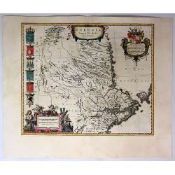
Uplandia.
A nice map of Uplandia, in central Sweden with its capital Stockholm. From 'Theatrum Orbis Terrarum, sive Atlas Novus in quo Tabulæ et Descriptiones Omnium Regionu' by w...
Place & Date: Amsterdam, 1645
Selling price: $165
Sold in 2021
Gothia.
Very decorative map of the southern part of Sweden. The forested topography and lakes are well depicted.The main feature of the engraving is the large title cartouche sur...
Place & Date: Amsterdam, 1645
Selling price: $200
Sold in 2023
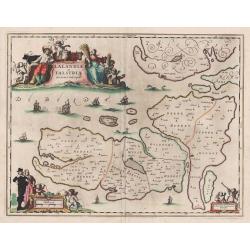
Lalandiae et Falstriae Accurata Descriptio.
Map of some regions of Denmark, from Sive Theatrum Orbis Terrarum. Text in Latin on the back.
Place & Date: Amsterdam, 1647
Selling price: $170
Sold in 2014
Fionia.
A pretty map of Fionia (Funen) from the Mercator Hondius “Atlas Minor” published in Amsterdam in 1648 (with Janssonius) with German text on verso. In 1607, Jodocus Ho...
Place & Date: Amsterdam, ca 1648
Selling price: $50
Sold in 2019
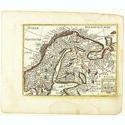
Tabula exantissima Regnoru Suecia et Norvegia
Finely detailed map showing Scandinavia (Denmark, Sweden, Norway, Finland), and White Sea region with a pretty cartouche in the upper left.
Place & Date: Frankfurt, 1649
Selling price: $100
Sold in 2010
Regni Danemark daniae accuratissime delineatio.
Detailed map of Denmark in a first state, without the names of the dioceses in Jutland added in the second state. Three beautiful cartouches with a dedication to Gerardus...
Place & Date: Amsterdam, 1644-1649
Selling price: $150
Sold in 2012
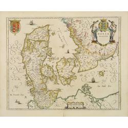
Dania Regnum.
Standard map of Denmark with fine title cartouche and coat of arms.
Place & Date: Amsterdam 1650
Selling price: $255
Sold
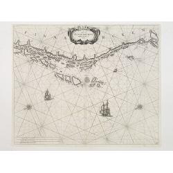
De Cust van Finmarcken tusschen Dronten en Sanien.
Uncommon chart of the coasts of Finnmark, centered on the Moskstraumen (popularly known as the Maelstrom) one of the strongest whirlpools in the world, that forms in a st...
Place & Date: Amsterdam 1650
Selling price: $200
Sold
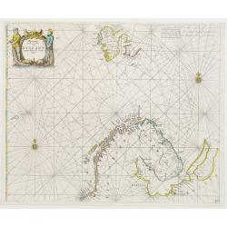
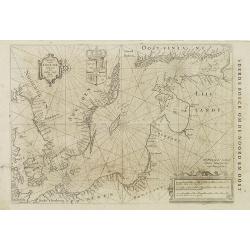
Pascaart Vande zeecusten van Ruslant, Laplant, Finmarcken en Spitzbergen.
It shows the most western part of Russia's north coast, the northernmost part of Scandinavia and Spitsbergen.
Place & Date: Amsterdam 1650
Selling price: $775
Sold
Dioecenis Stavangriensis . . .
Map of Southern Norway with Bergen and Stavanger.
Place & Date: Amsterdam, 1650
Selling price: $300
Sold in 2011
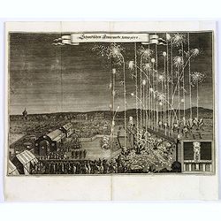
Schwedischen Feiverwerks, Anno 1650,
A night time fireworks display watched by an enthusiastic crowd, a print by M.Merian, published in his "Theatrum Europaeum." Banner title in German.
Place & Date: Frankfurt am Main, 1650
Selling price: $45
Sold in 2019
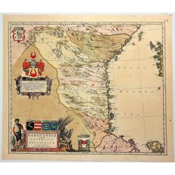
Suecia, Dania et Norvegia, Regna Europae Septentrionalia.
Decorative map of Scandinavia.
Place & Date: Amsterdam, 1655
Selling price: $240
Sold in 2014
Pascaart vande Oost-Zee beschreven door Willem Ians Blauw ao. 1622.
Very rare chart of the Baltic Sea and the Gulf of Finland. Published in De groote Zee-spiegel. inhoudende een korte Onderswij singe in de konst der zeevaert en eene besch...
Place & Date: Amsterdam, Joan Blaeu, 1655-1658
Selling price: $1000
Sold in 2010
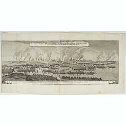
Königl: Dänemarck Haupt u. Reßi: Statt Coppenhagen, wie solche von dem König in Schweden A. 1658.
Impressive large copper engraving with a view of the siege of Copenhagen by, among others, the Swedish king between 1658 and 1659, made by Merian and published around 166...
Place & Date: Frankfurt, ca 1658
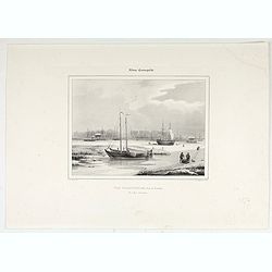
Album Cosmopolite - Vue d'Amsterdam, Prise de Saardam.
View of Amsterdam, from Zaandam. Drawn by L. Mayer, Amsterdam, engraved by St. Aulaire A. and published by Roger & Cte, r.richer, 7.
Place & Date: Frankfurt, ca 1658
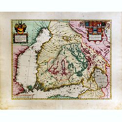
Magnus Ducatus Finlandiae Auct. Andrea Bureo Succo.
The first printed survey map of Finland, composed by the Swedish cartographer Anders Bureus (1571-1661). The map was published in 1662 in the second volume of Joan Blaeus...
Place & Date: Amsterdam, 1660
Selling price: $2500
Sold in 2015
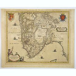
Sueonia Proprie fie dicta.
A very decorative map of eastern Sweden. Several beautiful cartouche are displayed. The left side is adorned with municipal code of arms.
Place & Date: Amsterdam, 1660
Selling price: $265
Sold in 2009
Sueonia Proprie Sie Dicta.
A very decorative map of eastern Sweden. Several beautiful cartouches are displayed. The left side is adorned with six municipal code of arms. There are a total of six pu...
Place & Date: Amsterdam, 1660
Selling price: $375
Sold in 2019
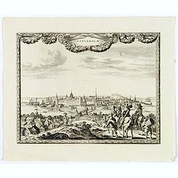
Stockholm.
An excellent and rare copperplate view of the Swedish capitol from the Afbeeldinghe der voornaemste steden van Europa.It shows a group of wealthy noblemen in the foregrou...
Place & Date: Amsterdam, ca 1660
Selling price: $150
Sold in 2018
Dioecensis Stavangriensis. . .
A fine and decorative map of southern Norway from 61 deg. N. with Oslo, Stavanger and Bergen prominently shown. The map presents a vivid view of the fjords and mountains ...
Place & Date: Amsterdam, ca 1660
Selling price: $110
Sold in 2019
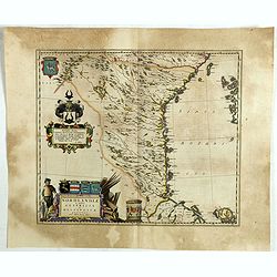
Nordlandiae et quibies Gestricia et Helsingicae regiones.
It shows the east central part of Sweden Gästrikland and Hälsingland). The body of water to the east is the Gulf of Bothnia.The map is enhanced by a number of decorativ...
Place & Date: Amsterdam, 1661
Selling price: $52
Sold in 2019
Ducatus Sleswici Pars Borealis. Johannnes Mejerus Husum.
Johan Blaeu succeeded his father Willem when the latter died in 1638. Johan led the Blaeu firm to its greatest achievement, the ' Atlas Maior' in 12 parts, the greatest a...
Place & Date: Amsterdam, 1662
Selling price: $450
Sold
Tabula Islandiae
Nice copy of Blaeu's Iceland map. Latin text on verso.
Place & Date: Amsterdam, 1662
Selling price: $500
Sold in 2009
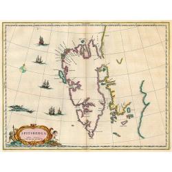
Spitsberga.
Nice copy of Blaeu's map of Spitsbergen.
Place & Date: Amsterdam, 1662
Selling price: $450
Sold in 2009
Episcopatus Stavangriae pars Australis.
South Stavanger from Blaeu's Major atlas.
Place & Date: Amsterdam, 1662
Selling price: $300
Sold in 2009
Norlandiae et Quibies Gestricia et Helsingicae Regiones.
A striking, rare map with a cartouche dedicated to Gabriel Bengtsson Oxenstierna. The 'Atlas Maior' is the epitome of decades of achievement by the famous Blaeu family. P...
Place & Date: Amsterdam, 1662
Selling price: $300
Sold in 2017
Nordlandiae et Quibies Gestricia et Helsingicae Regiones.
A fine antique map of Sweden or Norrland, with two originally colored cartouches, a figured title cartouche and a heraldic cartouche, with a total of six coats-of-arms in...
Place & Date: Amsterdam, 1662
Selling price: $370
Sold in 2018
Danmarck. (30).
Scarce map of Denmark published by Antoine de Fer in 1661 or 1662 in "Cartes de géographie revues et augmentées". With number 30 in lower right bottom of the ...
Place & Date: Paris, Antoine de Fer, 1657 but 1661 or 1662
Selling price: $45
Sold in 2018
Norvege et Suede. (31).
Scarce map of Norway, Finland and Sweden published by Antoine de Fer in 1661 or 1662 in "Cartes de géographie revues et augmentées". With number 31 in lower r...
Place & Date: Paris, Antoine de Fer, 1657 but 1661 or 1662
Selling price: $80
Sold in 2018
Praefectura Apenrade et Luntoft herde.
This highly decorative and map of southern Denmark centres on the town of Aabenraa. This historical map is from the famous Atlas Maior published in Amsterdam in 1662. The...
Place & Date: Amsterdam, 1662
Selling price: $42
Sold in 2021
Sveciae Regnum.
An attractive map of the Kingdom of Sweden from the famous Blaeu company.
Place & Date: Amsterdam, 1664
Selling price: $600
Sold
Daniae Typus.
Charming little map of Denmark made by Gabriel Bucelin (1599-1681). Bucelin was a Swiss genealogist and an author of several books and a number of manuscript maps of Germ...
Place & Date: Ulm, Johannes Görlin, 1658-1664
Selling price: $190
Sold in 2008
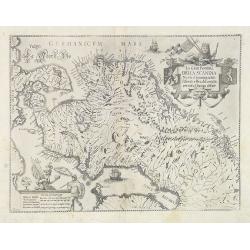
La Gran Penisola DELLA SCANDIA Madre d innumerabili Essercili e Regali Famiglie pertutta l'Europa diffuse.
Scarce map of Scandinavia with decorative cartouche and scale of miles, north orientated to the right. Engraved by Antonio de Piene for "Emmanuele Tesauro's Del Regn...
Place & Date: Turin, 1664
Selling price: $450
Sold
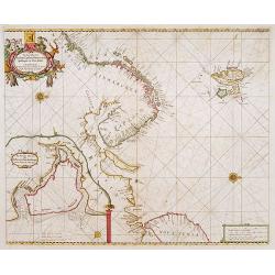
De Zee Custen van Ruslant, Laplant, Finmarcken, Spitsberg..
An eye-catching chart of Scandinavia, including Russia, with west to the topPieter Goos (ca. 1616-1675) was one of the most important cartographer, engraver, publisher an...
Place & Date: Amsterdam 1666
Selling price: $780
Sold
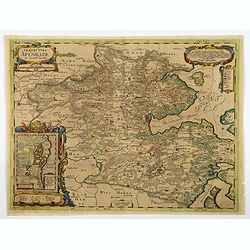
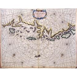
![Finlande septentr[iona]le et Mérid[iona]le, Nylande, et Tavasthus. . .](/uploads/cache/28355-250x250.jpg)
Finlande septentr[iona]le et Mérid[iona]le, Nylande, et Tavasthus. . .
Map of the southern part of Finland, including Helsinki, Salo, Turku, etc.
Place & Date: Paris, Mariette, 1666
Selling price: $400
Sold in 2009
Caarte van Finmarcken van 't Eylandt Sanien tot Noordkyn...
Uncommon chart depicting the coast of Finnmark, in Norway.A decorative title cartouche, rhumb lines, three vessels and two compass roses. Published 1666 by J. Theunisz an...
Place & Date: Amsterdam, 1666
Selling price: $290
Sold in 2018
![Finlande septentr[iona]le et Mérid[iona]le, Nylande, et Tavasthus. . .](/uploads/cache/36574-250x250.jpg)
Finlande septentr[iona]le et Mérid[iona]le, Nylande, et Tavasthus. . .
Map of the southern part of Finland, including Helsinki, Salo, Turku, etc.
Place & Date: Paris, Mariette, 1666
Selling price: $400
Sold in 2017
Scandinavie ou sont les Estats de Danemark, de Suede & C. . .
Map of Scandinavia prepared by N.Sanson and published by Pierre Mariette. Some contemporary manuscript annotations in brown ink. Published in an early edition of the smal...
Place & Date: Paris, P. Mariette, 1667
Selling price: $230
Sold in 2012
Danemarck.
Rare map of Denmark, published by Jollain in 1667. Published in "Trésor Des Cartes Geographiques Des Principaux Estats de Lunivers".This atlas is based upon Bo...
Place & Date: Paris, 1667
Selling price: $60
Sold in 2021
Gouvernement de Bahus tire de divers Memories.
An attractive map covering modern day Sweden and Norway, with just the northern tip of Jutland also. When this map was published Bahus belonged to Norway, however, it now...
Place & Date: Paris, 1668
Selling price: $385
Sold in 2018
Dania.
A detailed miniature map of Denmark, and the southern part of Sweden. Also parts of northern Germany. From the delightful pocket edition of John Speed's atlas by Van Den ...
Place & Date: London, 1668
Selling price: $21
Sold in 2018
Estats de la couronne de SUEDE dans la Scandinavie..
Map of Sweden and Finland, with original or early outline hand-color. Numerous place-names of counties, cities, towns, physical features.
Place & Date: Paris, 1669
Selling price: $425
Sold in 2009
Estats de la Couronne de Suede dans la Scandinavie, ou Sont Suede, Gotlande, Lapponie Suedoise, Finlande, Ingrie et Livonie Subdivisées en leurs Provinces . . .
Attractive map of Sweden, Finland and the Baltic States
Place & Date: Paris, Marriette, 1669
Selling price: $450
Sold
Tabula Regnorum Sueciae et Norvegiae.
Map of Sweden and Norway form a composition atlas from ca 1670.
Place & Date: Amsterdam, 1670
Selling price: $425
Sold in 2009
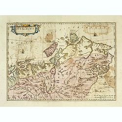
Finmarchia.
The map of Finnmark and northernmost Lapland based on the Great Scandinavian Atlas of Anders Bure (1626). This map was published in a Spanish text edition of the multi-vo...
Place & Date: Amsterdam, 1672
Selling price: $240
Sold in 2014
Tabula Islandiae Auctore Georgio Carolo Flandro.
A fascinating and very beautiful map of Iceland by Willem Janszoon Blaeu based on the work of Juris Carolus.Carolus was a Dutch traveler who probably derived his 1620s ma...
Place & Date: Amsterdam, ca. 1672
Selling price: $600
Sold in 2015
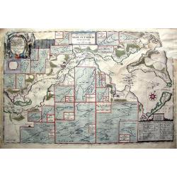
Accuratissima Sliae Fluminis Descriptio.
Rare map of Schlei Inlet of southern Jutland, Denmark. Highly detailed map, gives depth, tidal and channel information never before seen on a published map of the area. ...
Place & Date: Amsterdam, 1674
Selling price: $100
Sold in 2011
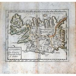
L'Islande.
Uncommon miniature map of Iceland from Pierre Duval's La Geographie Universeille. Following his Cartes de geographie in 1657, Pierre Duval published this smaller size atl...
Place & Date: Paris, 1676
Selling price: $90
Sold in 2008
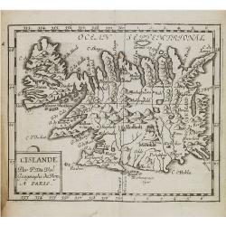
L'Islande par P. Du Val Geographe du Roy a Paris.
A nice, rare miniature map of Iceland from Pierre Duval's "La Geographie Universeille". Duval published a very small sized atlas containing a large number of ma...
Place & Date: Paris, 1676
Selling price: $90
Sold in 2016

Insula Islandia.
Uncommon derivative of this miniature map of Iceland, earlier published in Pierre Duval's La Geographie Universeille.The copper plate is newly engraved, and the name of D...
Place & Date: Nuremberg, 1678
Selling price: $400
Sold in 2016
La Scandinavia...
Giacomo Rossi's fine late 17th century map of Scandinavia. Issued in Il Mercurio geografico In upper left corner an ornate tittle cartouche. The cartographer was Giacomo ...
Place & Date: Rome, 1678
Selling price: $200
Sold in 2017