Browse Listings in Europe > Scandinavia
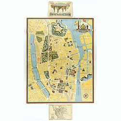
Kobenhavn / North Seeland.
A nice, large, colorful town plan of the Danish capital, published in 1946. The map covers in some detail from the central train station and the Tivoli Gardens, north up ...
Place & Date: Kobenhavn, 1946
Selling price: $65
Sold in 2018
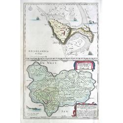
Helgolandia A o. 1649. / Helgoladt in annis Christi 800, 1300 & 1649. Johannnes Mejerus Husum.
Johan Blaeu succeeded his father Willem when the latter died in 1638. Johan led the Blaeu firm to its greatest achievement, the 'Atlas Maior' in 12 parts, the greatest an...
Place & Date: Amsterdam, 1662,
Selling price: $230
Sold
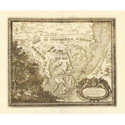
Castra Suedica ad Fridirici Uddam.
From Pufendorf's famous chronicle on the Baltic area, ' Histoire du règne de Charles Gustave, roy de Suède'The Swedish fortifications in front of Fredericia, 1657.
Place & Date: Nürnberg, C. Riegel, 1697.
Selling price: $75
Sold in 2008
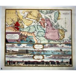
Accurate Carte der Uplandischen Scheren mit der Situation und Gegend umb die Konigle Schwedisch Haupt und Residentz Stadt Stockholm.
A decorative map and a pair of views, focusing on Stockholm and its environs. The map shows Stockholm and the area around it, focusing on the approach from the sea. The ...
Place & Date: Nuremberg , ca 720
Selling price: $335
Sold in 2021
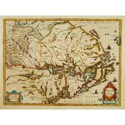
Uplandia.
Covers the area of the modern Uppsala, the vicinity of Stockholm, and includes most of Aland.
Place & Date: Amsterdam 1639-44
Selling price: $360
Sold
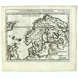
Suede, Danemark, et Norwege.
Scarce small map of Scandinavia based on cartography of Guillaume Delisle (. Published in "Nouveau traité de geographie par M**** ", published by La veuve Lott...
Place & Date: Paris, La veuve Lottin & Butard, P.G. Le Mercier, Rollin, David, Delag
Selling price: $50
Sold in 2016
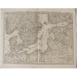
Seconde Carte des Carte des Courones Du Nord qui Comprend le Royaume De Denemark &c. A. Amsterdam chez J. Covens et C. Mortier
A map of the Baltic Sea Region with Denmark, Estonia and parts of Norway Sweden Finland Russia, Latvia Poland and Germany.
Place & Date: Amsterdam