Browse Listings in Europe > Russia / Baltic / Black Sea region > Russia general
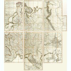
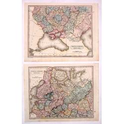
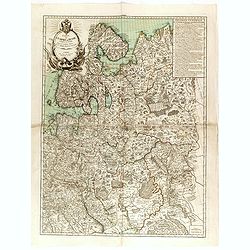
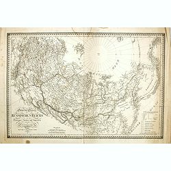
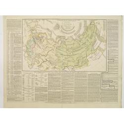
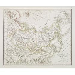
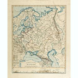
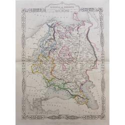
Carte des Europaisch- und eines Theils des Asiatisch russischen Reichs, nach den Neuesten Astronomischen Ortsbestimungen, den Grossen Atlas und Andern Karten des Russich-Kaiserl: Karten-Depots Verfasst ...
A large, rare (wall map sized) folding map of Russia, Lithuania, Poland with title in German and French published during the year of the Napoleonic campaign. Set consists...
Place & Date: Vienna, T. Mollo, 1812
Selling price: $1000
Sold in 2018
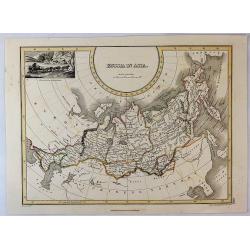
Asiatisches Russland.
Exciting and unusual copper-engraved map covering the area from Turkey to central Russia, showing parts of today's Russia, Kazakhstan, Ukraine, Georgia, Armenia, and Azer...
Place & Date: Vienna, 1813
Selling price: $100
Sold in 2010
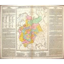
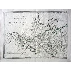
Geographical & Statistical Map of Russia.
Fine copper engraved map featuring Russia in Europe. Engraved by J. Walker after C. Gros and published by J. Barfield for Lavoisne's "COMPLETE GEOGRAPHICAL ATLAS&quo...
Place & Date: London, 1813
Selling price: $28
Sold in 2014
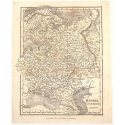
European Russia.
A fine 1815 Thomson map of the European part of Russia, engraved in the minimalist English style pioneered in the early part of the 19th century. Coincidentally, it was p...
Place & Date: Edinbourgh, 1815
Selling price: $15
Sold in 2021
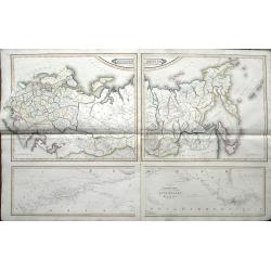
Russia In Europe - North Part & South Part (Two Maps).
Two fine hand-colored maps of Russia with excellent detail. (North and South Part) The mapmaker was Arrowsmith and they were engraved by Sidney Hall in London in 1817.
Place & Date: London, 1817
Selling price: $125
Sold in 2014
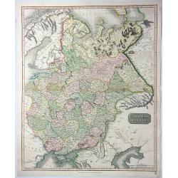
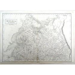
Russian Empire from the Best Authorities.
A fine copper engraved map of the Russian Empire, published in “An Atlas to Guthrie's Geographical Grammar” published in London in 1818.
Place & Date: London, 1818
Selling price: $19
Sold in 2018
Russian Empire from the Best Authorities.
A detailed map of Russia by Guthrie from “Guthrie’s Geography” published in London in 1818.William Guthrie (1708-1770) Guthrie was born in Brechin in Scotland. He w...
Place & Date: London, 1818
Selling price: $6
Sold in 2020
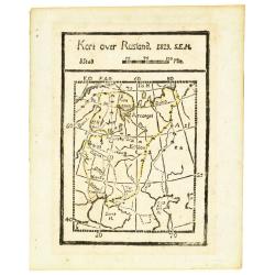
Kort over Rusland 1819 S.E.H.
Rare wood block printed map of European part of Russia, including Finland.
Place & Date: Denmark, 1819
Selling price: $50
Sold in 2013
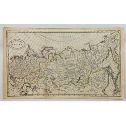
Russia in Asia.
An interesting map Russian Asia, mainly that of Siberia. It extends from Europe to the NW coast of America. Features a decorative vignette of a winter scene with sled and...
Place & Date: Edinburgh, 1819
Selling price: $65
Sold in 2019
Carte générale de l'Empire de Russie comprise en Europe, pour l'intelligence de la guerre présente entre l'Impératrice de toutes les Russies et le Turc. . .
Rare and detailed two-sheet map of European Russia, Finland, Lapland and Baltic States with an ornamental title cartouche in the upper left corner. Prepared by Maurille A...
Place & Date: Paris, ca. 1820
Selling price: $1500
Sold in 2014
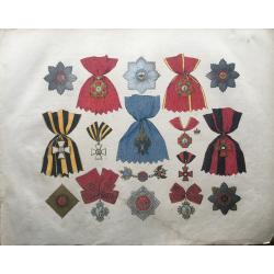
Russie Les Ordres Impériaux et Royaux et Marques d'honneurs
Extremely large, very decorative list of the medals and decorations of Russia. From an exceptionally rare lithographic work of Sperber and Herwig, printed in colors by He...
Place & Date: Deutschland, ca 1820
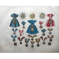
Russie Les Ordres Impériaux
Extremely large, very decorative list of the medals and decorations of Russia. From an exceptionally rare lithographic work of Sperber and Herwig, printed in colors by He...
Place & Date: Germany, ca 1820
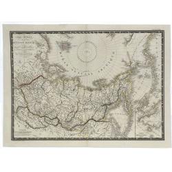
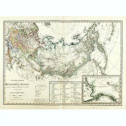
Carte Générale de la Russie d'Asie et des Regions Polaires Boreales.
A fine large-format 1821 Brué map of Russia and the Arctic Ocean featuring the North Pole at the upper centre of the map. Though not a true polar projection, it suggest...
Place & Date: Paris, 1821
Selling price: $17
Sold in 2019
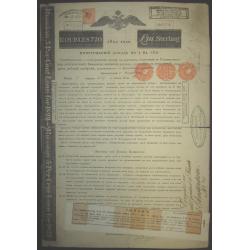
Russian 19th century loan with signature of famous Jewish German banker
Russian Empire, 5% Bond for 720 Roubles = £111, #62365 / 8174, issued 1822, as so often in heavily used condition with folds as well as one larger tear at centerfold (ap...
Place & Date: 1822
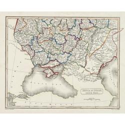
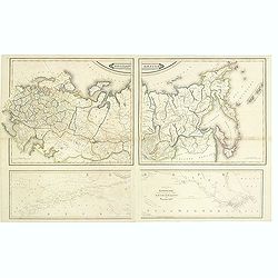
Russia in Europe south past.
Map showing the south of Russia around the Black Sea. Fine steel engraving by Sidney Hall after a drawing by A . Arrowsmith. Published by Archibald Constable
Place & Date: Edinburg, c. 1823
Selling price: $100
Sold in 2010
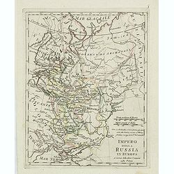
Impero della Russia in Europa. . .
Charming map of European part of Russia from the rare atlas Atlante Tascabile o sia Serie di Num. XXI Cartine Geografiche nelle quali si rappresenta in ristretto lo Stato...
Place & Date: Rome, 1823
Selling price: $100
Sold in 2011
General Charte des Russischen Reichs in Europa, Asien, und America. . .
Uncommon map of Russia, prepared by C.F.Weiland. In the upper right corner the tip of Alaska Major Russian cities are underlined in orange ink lines. To the lower right a...
Place & Date: Weimar, 1825
Selling price: $360
Sold in 2014
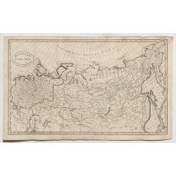
Russia in Asia
An attractive map of the eastern part of Russia. Published by Thomson in his "A GENERAL ATLAS...." in Edinburgh in 1825. The map is by James Wyld, the renowned ...
Place & Date: Edinburgh, 1825
Selling price: $20
Sold in 2016
General Charte des Russischen Reichs. . .
Rare map of Russia, including Poland, Baltic, Ukraine, Siberia, Kurilles and in the lower right corner an inset map of Alaska and Bering Street. Engraved and published by...
Place & Date: Nürnberg, 1826
Selling price: $950
Sold in 2014
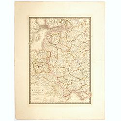
Carte Générale de la Russie d'Europe, du Royaume de Pologne, des environs de Caucase et d'une partie des Pays Adjacents.
A fine large-format 1826 A. H. Brué's map of the European Russia. It shows all of Poland and extends east to the Black Sea to show all of the Crimea, and north to above ...
Place & Date: Paris, 1826
Selling price: $12
Sold in 2019
L'Empire Russe en Europe et en Asie avec ses acquisitions..
Map showing the extension of the Russian Empire at the beginning of the XIXth century. Several letterpress notations are present on the map.Surrounding letterpress explan...
Place & Date: Paris, 1827
Selling price: $80
Sold in 2009
![[67 sheets - The Russian Empire in EUROPE & ASIA ]](/uploads/cache/35290-250x250.jpg)
[67 sheets - The Russian Empire in EUROPE & ASIA ]
A set of 67 maps covering the Russian Empire at time of publication. From his famous Atlas Universel . This atlas was one of the most remarkable world atlases ever produc...
Place & Date: Brussels, 1825-1827
Selling price: $4000
Sold in 2014
Mawman's Russia in Europe.
Fine little map of "Russia in Europe" published by J. Mawman & the Other Proprietors" in London in 1827. It was engraved by J. Neele.
Place & Date: London, 1827
Selling price: $26
Sold in 2015
Russia in Europe, Northern Part.
Detailed map of Northern Russia in Europe by Sidney Hall in 1827, published in London. It includes "Russian Lapland".
Place & Date: London, 1827
Selling price: $16
Sold in 2016
Carte de la Russie occidentale et du Royme. de Pologne par A. Brue, Geographe du Roi . . .
A large folio steel engraved map of Russia and Poland from his the Brue "Universal Atlas of physical geography, politics, ancient & modern." It shows wester...
Place & Date: Paris, 1827
Selling price: $40
Sold in 2020
Russie d'Asie. . .
Detailed map of Siberia, China and part of Alaska, prepared by A. H. Basset, rue Saint-Jacques, no. 64, Paris and published in Atlas classique et Universel de Géographie...
Place & Date: Paris, A.H. Basset, 1828
Selling price: $200
Sold in 2010
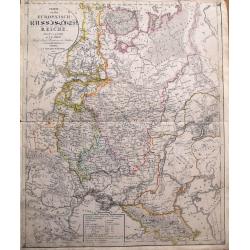
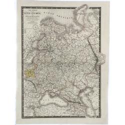
Charte von dem Europaeisch-Russischen Reiche...
Highly detailed map of Eastern Europe, from Finland to the Caspian Sea, centered on Moscow. Includes the Baltic's and the Ukraine. With a legend indicating the number of ...
Place & Date: Leipzig, 1829
Selling price: $56
Sold in 2014
Russian Empire / Chart of the communication between the archipelago and Black Sea.
Large 2-sheet map (from 4 plates) of the Russian Empire, pubslished by Daniel Lizars son, William Hole Lizars. The unusual map shows Russia in great detail with many plac...
Place & Date: Edinburgh, ca 1830
Selling price: $35
Sold in 2019
Russian empire. / Chart of the communication between the archipelago and black sea.
Printed on 2 sheets, each sheet has two maps printed from different copper plates. The lower map at 1:400,000 scale and includes northern part of the Black Sea with, Hell...
Place & Date: Edinburg, 1831
Selling price: $400
Sold in 2014
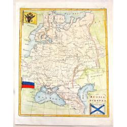
Russia Europa.
Pleasing map of Russia with three pertinant flags. Includes Russian flag as well as flags of war and mercantile marine. The flags covers Russia, poland, Lithuania, Estoni...
Place & Date: Florence, 1838
Selling price: $90
Sold in 2013
Empire de Russie.
Finely engraved map of Russia prepared by A.H.Dufour and engraved by Giraldon-Bovinet. Published by Jules Renouard in his uncommon atlas "Le globe Atlas classique Un...
Place & Date: Paris, Jules Renouard, ca.1840
Selling price: $40
Sold in 2012
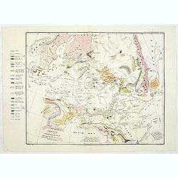
Sketch, to serve as a Basis for a Geological Map of European Russia, colored to show the connections of its Strata with those of the Surrounding Countries.
Uncommon geological map of Russia. Lithographed by B.R.Baker and printed by C.Hullmandel. From "Transactions of the Geographical Society".' With color key to th...
Place & Date: Transactions of the Geological Society c. 1840
Selling price: $100
Sold in 2011
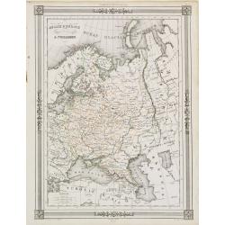
Russie d'Europe..
"Decorative map of Russia, prepared by J.G.Barbié du Bocage.Engraved by Ch.Smith, published by Basset who was established in Paris, rue de Seine 33. From ...
Place & Date: Paris 1846
Selling price: $10
Sold
Europaïsches Russland (Manuscript map)
Map of Russia, including Finland, Poland, Sweden and Norway and the Aral Sea in the east. Signed lower right "Carl Hoeckner" and most likely drawn by Carl Hoeck...
Place & Date: Hildburghausen, ca. 1849
Selling price: $700
Sold in 2014
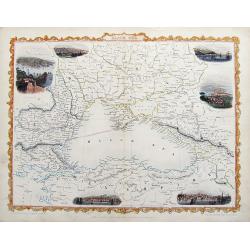
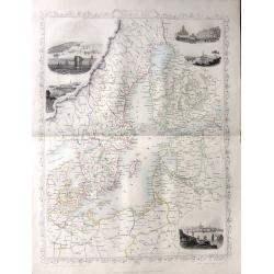
Black Sea.
A fine steel engraved map of the Black Sea and surrounding areas. With small decorative views of Sevastopol, Varna, Odessa, Sinope, Constantinople, and Silistria, all nic...
Place & Date: London, ca 1850
Selling price: $35
Sold in 2019
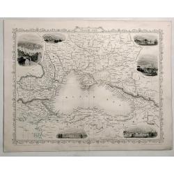
Black Sea.
Detailed and decorative map of The Black Sea with six vignettes of Sebastopol, Varna, Odessa, Sinope and Constantinople.. A John Tallis map published by The London Prin...
Place & Date: London, 1850
Selling price: $75
Sold in 2019
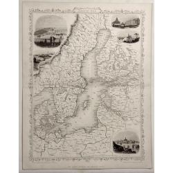
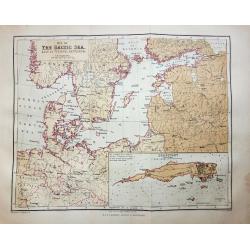
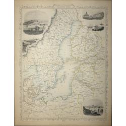
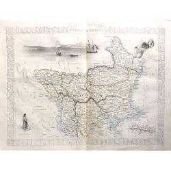
Baltic Sea.
Detailed and decorative map of The Baltic Sea with five vignettes of Kronstadt, Revel, St. Petersburg, Abo and Helsingfors. A John Tallis map published by The London P...
Place & Date: London, 1850
Selling price: $75
Sold in 2019
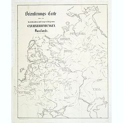
Orientirungs-Carte über die bestehenden und vorgechlagenen Canalverbindungen Russlands.
Uncommon map of the European part of Russia, showing the existing and proposed Canal system. Published in "Allgemeine Bauzeiting".The Allgemeine Bauzeitung was ...
Place & Date: Vienna, 1851
Selling price: $100
Sold in 2011
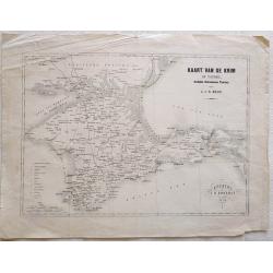
Kaart van de Krim of Taurië, (oudtijds Chersonesus Taurica).
Map of the southern part of Ukrain, between the Sea of Azov, The Black Sea, Karkinyts'ka Gulf and the Nogaic desert. After H.J.N. Huot.With the capitals, towns, villages,...
Place & Date: Utrecht, 1854
Selling price: $50
Sold in 2013
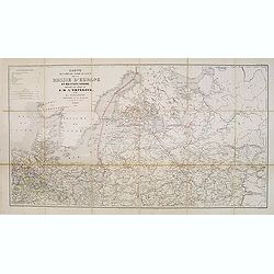
Carte des voies de cummunication de la Russie d'Erope et des etats voisins dressée par ordre se s.m. L'Empereur. . .
Detailed folding map of Northern part of Russia, prepared by L. Sagansan. The map is engraved on stone by the brothers Avril and printed by Kaeppelin in Paris.
Place & Date: Paris, 1854
Selling price: $250
Sold in 2015
The Russian & Ottoman Empires, Sweden, Denmark, Prussia & Austria.
Detailed map of Russia, Scandinavia, Turkey, Crimea and Black Sea and Caspian Sea. Including railway from Moscow to St. Petersburg.James Wyld (the younger) was geographer...
Place & Date: London, 1854
Selling price: $170
Sold in 2017
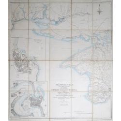
Cronstadt in the Baltic with the fortifications, batteries's & range of the guns &c.
A rare map showing the area around Cronstadt, which was an island defense for St Petersburg. The map includes the range of guns in addition to the position of the fortifi...
Place & Date: London, 1854
Selling price: $500
Sold in 2015
Philips' new map of the Crimea with map of Europe and view of Sevastopol.
A well-preserved copy of this charming folding map of Russia, Poland and the Baltic States. With charming original hardcover red wrapper richly decorated with flower desi...
Place & Date: London, 1854
Selling price: $100
Sold in 2014
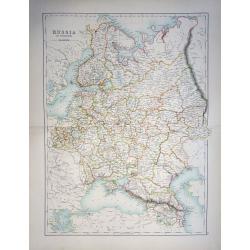
Russia in Europe
A highly detailed and attractive map of European Russia engraved by William Hughes – Sidney Hall, steel engraved.Published by Adam & Charles Black in the ‘General...
Place & Date: Edinburgh, 1854
Selling price: $65
Sold in 2019
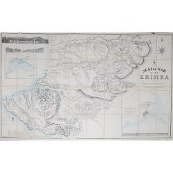
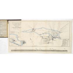
Seat of War in the Krimea.
Steel engraved folding map of the Krimea with original hand color. With panoramic views of Sevastopol, Balaklava and Eupatoria from Anchorage. Maps of the Black Sea and a...
Place & Date: London, 1855
Selling price: $140
Sold in 2012
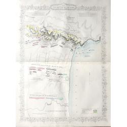
Stanford's Map of the Roads &c. Between Odessa, Nikolaief, Perekop, Simfieropol, and Sebastopol.
Folding map of south-eastern Ukraine, focusing on the region between Odessa and just east of Balaklava. Large inset maps of Odessa and Nikolayev to left edge. The whole d...
Place & Date: London, 1855
Selling price: $220
Sold in 2012
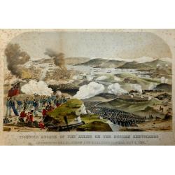
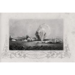
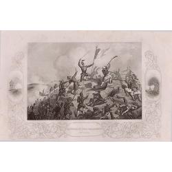
Vigorous Attack of the Allies on the Russian Ambuscades In front of the Mamelon and Malakoff Towers, May 9, 1855.
A highly detailed lithograph showing the battle to silence the Malakoff Towers. In the distance a view of Sebastopol looking towards the Dockyard Harbour... The Malakoff ...
Place & Date: London, 1855
Selling price: $40
Sold in 2017
Russia in Europe showing the Territorial Acquisitions since the time of Peter the Great.
"Russia in Europe showing the Territorial Acquisitions since the time of Peter the Great" This map shows the acquisitions from Turkey, Sweden, Poland and Persia...
Place & Date: London, 1855
Selling price: $80
Sold in 2019
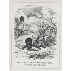
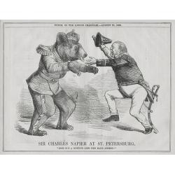
A set of 15 humorous prints from the Russian Empire's war with the French and British Empire's.
This set of 15 are from 1847 - 1856. Mostly engraved by Joseph Swain. Joseph Swain was one of the most important woodblock engravers. Punch was responsible for the word s...
Place & Date: London 1847 - 1856
Selling price: $100
Sold in 2015
A set of 15 humorous prints from the Russian Empire's war with the French and British Empire's.
This set of 15 are from 1846 - 1856. Mostly engraved by Joseph Swain. Joseph Swain was one of the most important woodblock engravers. Punch was responsible for the word s...
Place & Date: London 1846 - 1856
Selling price: $100
Sold in 2015

A set of 16 humorous woodblock prints from the Russian Empire's war with the French and British Empire's.
This set of 16 are from 1853 - 1856, mostly engraved by Joseph Swain. Joseph Swain was one of the most important woodblock engravers.Punch was responsible for the word se...
Place & Date: London, 1853 - 1856
Selling price: $100
Sold in 2015
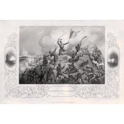
Four lithographic scenes from the Crimean War.
Four lithographic scenes from the Crimean War, based on sketches by William Simpson, which were published in London by Paul and Dominic Colnaghi & Co.- The Charge of ...
Place & Date: London, 1856
Selling price: $200
Sold in 2017
A set of 8 maps from The Crimea War.
A set of 8 maps from The Crimea War 1856. By W. & A.K Johnston, published by W & R Chambers London 1856. The titles: 'Portion of The Crimea Forming Chief Scene of...
Place & Date: London, 1856
Selling price: $120
Sold in 2016

A set of 16 humorous woodblock prints from the Russian Empire's war with the French and British Empire's.1853 - 1857.
This set of 16 are from This set of 16 are from 1853 - 1857, mostly engraved by Joseph Swain. Joseph Swain was one of the most important woodblock engravers. Punch was re...
Place & Date: London, 1853 -1857
Selling price: $100
Sold in 2015
(Crimea) A complete set of 26 engravings depicting The Crimea war, the Battles between the Russian Empire ...
A complete set of 26 engravings depicting The Crimea war, the Battles between the Russian Empire and several European powers for influence over territories of the declini...
Place & Date: London, 1858
Selling price: $1000
Sold in 2015
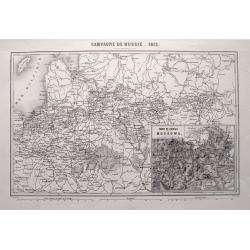
CAMPAGNE DE RUSSIE 1812.
Highly detailed map showing the area from Poland and the Baltics to Moscow, including the cities of Kiev, Minsk, Smolensk, Riga, and many more. An inset map shows the are...
Place & Date: Paris, 1858
Selling price: $32
Sold in 2015
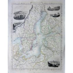
Baltic Sea - John Tallis
A highly detailed and decorative map of the Baltic Sea and surrounding countries with five vignette illustrations.One of the John Tallis maps published around the time of...
Place & Date: London, 1858
Selling price: $75
Sold in 2015
(Crimea) A set of 24 engravings depicting The Crimea war, the Battles between the Russian Empire and several European powers for influence over territories of the declining Ottoman Empire.
A set of 24 engravings depicting The Crimea war, the Battles between the Russian Empire and several European powers for influence over territories of the declining Ottoma...
Place & Date: London, 1858
Selling price: $250
Sold in 2015
Baltic Sea - John Tallis
A highly detailed and decorative map of the Baltic Sea and surrounding countries with five vignette illustrations.One of the John Tallis maps published around the time of...
Place & Date: London, 1858
Selling price: $65
Sold in 2016
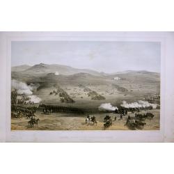
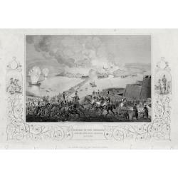
Plan of The Battle of The Alma
A highly detailed battle plan depicting the 'Battle of the Alma River in Crimea', one of the first battles of the Crimean War.The Battle of the Alma was fought September ...
Place & Date: London, 1858
Selling price: $65
Sold in 2016
'Turkey in Europe'
A highly decorative and detailed mid-19th century map of 'Turkey in Europe' The Balkans: northern Greece, Macedonia, Bulgaria, Albania, Serbia, Bosnia-Herzogovina, southe...
Place & Date: London, 1858
Selling price: $60
Sold in 2016
‘The Crimea War' 18 engravings depicting the Battles between the Russian Empire and the European powers for influence over territories of the declining Ottoman Empire, and the Military Leaders of the European powers.
‘The Crimea War.’ 18 engravings depicting the Battles between the Russian Empire and the European powers for influence over territories of the declining Ottoman Empir...
Place & Date: London, 1858
Selling price: $140
Sold in 2016
Baltic Sea
A highly detailed and decorative map of the Baltic Sea and surrounding countries with five vignette illustrations.One of the John Tallis maps published around the time of...
Place & Date: London, 1858
Selling price: $65
Sold in 2016
20 engravings depicting The Crimea war, the Battles between the Russian Empire and several European powers for influence over territories of the declining Ottoman Empire, Nicholas I. Emperor of Russia and Military Leaders of the European Powers.
An interesting set of 20 engravings depicting The Crimea war, the Battles between the Russian Empire and several European powers for influence over territories of the dec...
Place & Date: London, 1858
Selling price: $120
Sold in 2017
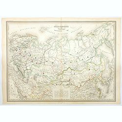
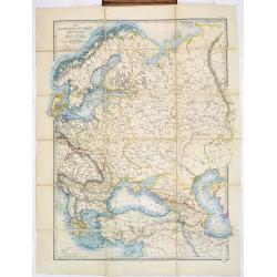
Russie Europeenne et Asiatique.
A large detailed map of the entirety of the Russian Empire, as it was under Czar Alexander II in the middle of the nineteenth century. Also shown as part of the map are F...
Place & Date: Paris, 1858
Selling price: $16
Sold in 2020
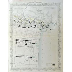
Plan of the Battle of the Alma.
A detailed steel engraved map of the Battle of Alma The map includes a hand colored key as to the positions of the English, French, Turks, and Russians. Inscription: Draw...
Place & Date: London, 1858
Selling price: $80
Sold in 2020
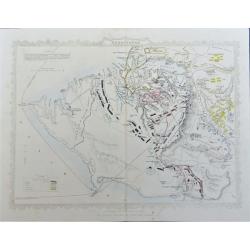
Siege of Sebastopol.
A detailed steel engraved map of Sebastopol. The map includes a hand colored key as to the positions of the English, French, Turks, Russians, and Sardinians. Dates and po...
Place & Date: London, 1858
Selling price: $80
Sold in 2020

A set of 16 humorous woodblock prints from the Russian Empire's war with the French and British Empire's.
This set of 16 plates are from 1854 - 1859, mostly engraved by Joseph Swain. Joseph Swain was one of the most important woodblock engravers. Punch was responsible for the...
Place & Date: London, 1854 -1859
Selling price: $100
Sold in 2015
Europish Rusland.
Uncommon map of Russia. Lithography by J.H. van Weijer, published in Atlas der geheele Aarde [?] in 24 kaarten. With colored key to processions.
Place & Date: Groningen, ca. 1860
Selling price: $30
Sold in 2008
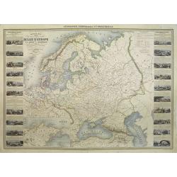
Nouvelle carte illustrée des Etats du Nord et de l'Europe donnant la Russie d'Europe La Suède et le Danemark . . .
A most decorative mid 19th century map, in left and right part 20 vignettes giving a wealth of statistic and commercial information. Besides Russia's provinces the neighb...
Place & Date: Paris, ca. 1860
Selling price: $300
Sold in 2009
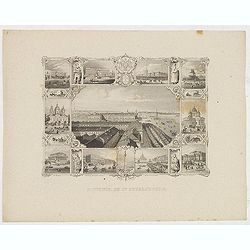
Souvenir de St. Petersbourg.
Panoramic view of St. Petersburg surrounded with ten little views of different places and monuments.
Place & Date: France, ca. 1860
Selling price: $100
Sold in 2013
Europa und der nördliche Theil von Asien.
Somewhat later but very finely drawn map of Europe and the rendering of Russia. Including "Berings Srasse" and tip of North America with "Aleutische Inseln...
Place & Date: Germany, ca. 1860
Selling price: $55
Sold in 2014
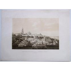
KIEV. Kyiv-Pechersk Lavra Monastery
Extremely rare, fine tinted lithographed general view of the Kyiv-Pechersk Lavra Monastery. [Kiev Monastery of the Caves] An edition of the Kyiv-Pechersk Lavra Monastery...
Place & Date: KIEV, 1860
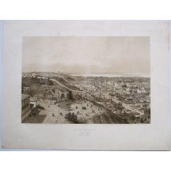
KIEVO-PODOL. - KIEV, GENERAL VIEW
Extremely rare, fine tinted lithographed general view of Kiev/Kyiv from the South. With key under the view on the main churches and monasteries of the town.An edition of ...
Place & Date: KIEV[Paris], 1862
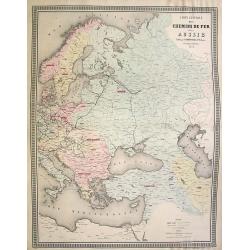
Carte generale des Chemins de fer de la Russie..
Fine map of Russia, Scandinavia, Germany, showing the early railway system of the area. From Atlas des Chemins de Fer published by Napoléon Chaix and printed by Imprimer...
Place & Date: Paris 1863
Selling price: $90
Sold in 2008
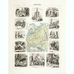
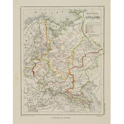
Russland.
This is a rare decorative map of Russia with informative borders, published in Brockhaus' Illustrierter Handatlas .
Place & Date: Leipzig, 1863
Selling price: $190
Sold in 2011

A set of 16 humorous woodblock prints from the Russian Empire's war with the French and British Empire's.
This set of 16 are from 1853 - 1863, mostly engraved by Joseph Swain. Joseph Swain was one of the most important woodblock engravers.Punch was responsible for the word se...
Place & Date: London, 1853 - 1863
Selling price: $100
Sold in 2015
A set of 16 humorous woodblock prints from the Russian Empire's war with the French and British Empire's.
This set of 16 are from 1853 - 1863, mostly engraved by Joseph Swain. Joseph Swain was one of the most important woodblock engravers. Punch was responsible for the word s...
Place & Date: London 1853 - 1863
Selling price: $100
Sold in 2015
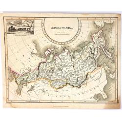
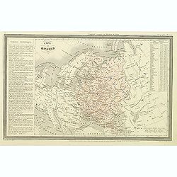
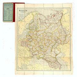
Russia in Europe.
A highly detailed map of Russia in the late 19th century. The provinces are separated by coloring. Published in Edinburgh by Adam & Charles Black
Place & Date: Edinburgh, 1870
Selling price: $60
Sold in 2014
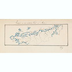
![[Tittle in Russian] Kapta. . . (Map of the Russian North Coast).](/uploads/cache/29142-250x250.jpg)
[Tittle in Russian] Kapta. . . (Map of the Russian North Coast).
A detailed wall map sized map of the Northern coast of Russia with a color key in top which seems to highlight the various Russian Artic explorations along the coast usin...
Place & Date: Moscow, 1872
Selling price: $650
Sold in 2014