Browse Listings in Europe > Russia / Baltic / Black Sea region > Estonia / Latvia / Lithuania
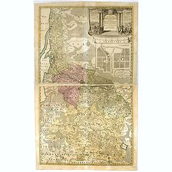
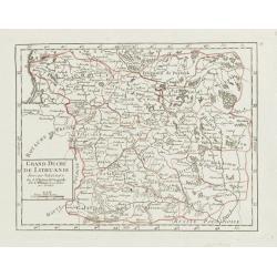
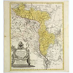
Potentissimo Borussorum Regi Friderico Wilhelmo Maiestate, Fortitudine Clementia Augustissimo Hancce Lithuaniam Borussicam : in qua luca coloniis Salisburg., ad incolendum Regio nutu concessa chorographice exhibentur D. D. D. Regiae Suae Maiestatis.
Large 2-sheet map of an area of Lithuania and Eastern Prussia (Russian province of Kaliningrad) stretching from Klaipeda (Memel) in the north to Goldap in the south (a to...
Place & Date: Nuremberg, 1735
Selling price: $650
Sold in 2016
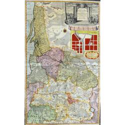
Potentissimo Borussorum Regi Friderico Wilhelmo...
Large and sought-after 2-sheet map of an area of Lithuania and Eastern Prussia (Russian province of Kaliningrad) stretching from Klaipeda (Memel) in the north to Goldap i...
Place & Date: Nuremberg, 1735
Selling price: $600
Sold in 2020
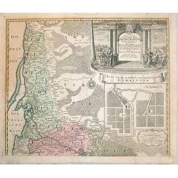
Potentissimo Borussorum Regi Friderico Wilhelmo Maiestate, Fortitudine Clementia Augustissimo Hancce Lithuaniam Borussicam : in qua luca coloniis Salisburg., ad incolendum Regio nutu concessa chorographice exhibentur D. D. D. Regiae Suae Maiestatis'
Upper part of a 2-sheet map of an area of Lithuania and Eastern Prussia (Russian province of Kaliningrad) stretching from Klaipeda (Memel) in the north to Goldap in the s...
Place & Date: Nuremberg, ca. 1740
Selling price: $330
Sold in 2016
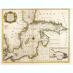
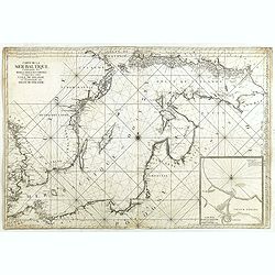
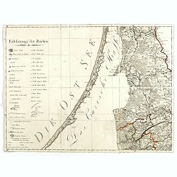
A correct chart of the Baltick or East Sea from ye Sound to St. Petersburg. . .
Attractive uncommon sea chart of the Baltic Sea. Inset plan of St Petersburg (97x131mm.) . Compass rose and rhumb lines. Decorative title cartouche. Engraved by R.W. Seal...
Place & Date: London, 1742
Selling price: $200
Sold in 2015
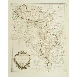
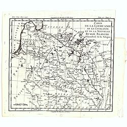
Grand Duché de Lithuanie divisé par Palatinats.
Small detailed map centered on Lithuania and Belarus. From Atlas Portatif Universel, by Robert de Vaugondy.Unrecorded state with erased date. Page 38 outside border top r...
Place & Date: Paris, later than 1748
Selling price: $106
Sold
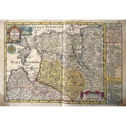
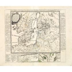
Die Hertzogthümer Curland und Liefland...
Unusual map of the Baltic area which nowadays is mainly covered by Latvia and Estonia. Extends from Libau to St. Petersburg in Russia, including Riga, Revel (Tallinn), Na...
Place & Date: Leipzig, 1749
Selling price: $46
Sold in 2016
Carte de la Mer Baltique contenant les bancs, isles et costes comprises entre l'isle de Zelande et l'extrémité du Golfe de Finlande.
Important chart of the Baltic Sea with the coasts of Sweden, Finland, Russia, Estonia, Lettland, Lithuania and Poland. With many place names along the coasts, anchor plac...
Place & Date: Versailles, 1753
Selling price: $1000
Sold in 2014
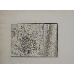
Plan de MEMEL
Very rare and highly detailed miniature map of Memel city (Klaipėda, Lithuania). It is detailed view of the year 1757 19th of June march of the Russian army to Prussia a...
Place & Date: 1757
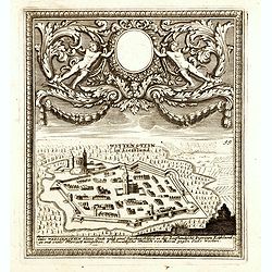
(Paide) Wittenstein in Lieffland / Wittenstein in Lieffland Oder Weissenstein kleine Stadt nebst eine Starken Schloss in der Lieflandische Provinz Estland. . .
Rare bird's eye view of Paide in Estonia by George Christian Kilian. The upper part of the engraving has very nice baroque decoration with an empty shield.Georg Christian...
Place & Date: Augsburg, 1760
Selling price: $100
Sold in 2014

Dvcatvvm Livoniae et Cvrlandiae cum vicinis. . .
A very attractive of Livonia, Estonia, Curlandia and the Baltic coast.
Place & Date: Nuremberg, 1760
Selling price: $300
Sold in 2016
![KLAIPEDA, Lithuania: [Regni Borussiae Episcopatus Warmiensis Palatinatus Mariaeburgensis] et Culmensis cum Territorio Dantiscano et Ichnographia Urbis. . .](/uploads/cache/37064-250x250.jpg)
KLAIPEDA, Lithuania: [Regni Borussiae Episcopatus Warmiensis Palatinatus Mariaeburgensis] et Culmensis cum Territorio Dantiscano et Ichnographia Urbis. . .
Second plate of a rare wall map, shows the territory around Klaipeda (Memel) in Lithuania. Between 1701–1871 the area belonged to the Kingdom of Prussia. This wall map ...
Place & Date: Berlin, Preussische Akademie der Wissenschaften 1763-1766
Selling price: $800
Sold in 2016
Suite de la route de Paris a Tobolks par Rotnica, Riga et Kipina.
Rare map showing Lithuania, Latvia, Estonia and part of Poland. The map has original out line color and the route taken by Jean Chappe d'Auteroche crossing this area is d...
Place & Date: Paris, 1768
Selling price: $500
Sold in 2017
Charte von Russisch Litauen, ...
An uncommon map of Belarus, together with parts of the Ukraine and Lithuania. Shows the rivers Dnieper and Dwiner.
Place & Date: Nuremberg, 1775
Selling price: $285
Sold in 2017
Carte de la Lithuanie Russienne qui comprend les Palatinats de Livonie de Witepsk, de Miscislaw..
Detailed map of Belarus, Latvia with the river Dnepr. Included are towns as Smolensk, Orsa, Minsk, etc.Santini gives credit to Homann Heirs in the cartouche. °
Place & Date: Venise 1776
Selling price: $210
Sold
Carte de la Lithuanie Prussienne qui comprend les Palatinats de Livonie, de Witepsk, de Liscislaw, et une partie de ceux de Polock et de Minsk cédés par la Pologne à la Russie. Dressée sur l'Exemplaire des Héritiers Homann 1775.
Detailed map of the areas along the river Dnieper and Duna. Santini gives credit to Homann Heirs in the cartouche.The map was prepared by the Venetian cartographer and pu...
Place & Date: Venice, 1776
Selling price: $500
Sold in 2009
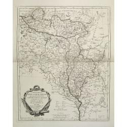
Carte de la Lithuanie, de la Courlande, et de la nouvelle Russie Blanche démembrée de la Pologne.
A map of the Lithuania territories of Louis Brion de la Tour, from the work "Histoire universelle depuis le commencement du monde jusqu a present" published in ...
Place & Date: Paris, 1779
Selling price: $75
Sold in 2019
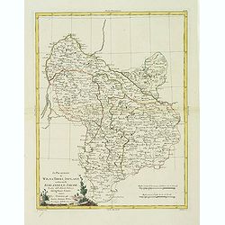
Li Palatinati di Wilna, Troki, Inflant, coi Ducati di Kurlandia, e Smudz. . .
A attractive and detailed map Latvia and northern Lithuania, marking Vilnius (Wilno), Riga and many other towns.. The decorative and large pictorial title cartouche is fu...
Place & Date: Venice, 1782
Selling price: $290
Sold in 2012
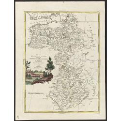
Ducati di Livonia, e di Estonia, e governi di Nowogorod, Bielogorod e Kiowia.
The nice map depicting vast territory of present days Estonia, Latvia, Belarus, Russian Federation and Ukraine. Those days territory belonged to Livonia, Polish-Lithuania...
Place & Date: Venice, 1782
Selling price: $100
Sold in 2019
Neue Karte von den gegenwärtigen Kriegs-Schauplatze zwischen den Russisch-Kayserl.
Very rare separately published map showing the Russian War seat including Finland, Lithuania, Denmark and parts of Poland, Norway and Sweden. In lower part inset maps of ...
Place & Date: Leipzig, 1788
Selling price: $2100
Sold in 2013
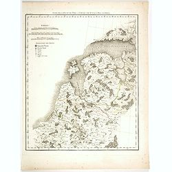
Der Baltische Hafen.
A curious map of the Pakri Islands in Estonia. With Suur-Pakri and Väike-Pakri and the near coast of Paldiski.A legend (a-h) names a sunken ship among other things! Furt...
Place & Date: Unknown, ca. 1800
Selling price: $100
Sold in 2017
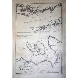
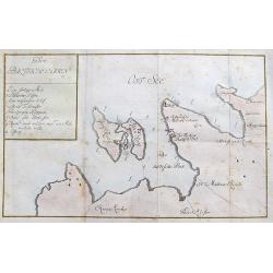
SPECIAL KARTA ösver RÄGER-VIK
Rare page with two maps. The map on top showing the coasts of Estonia and Finland at the Finnish sea bosom. Includes the city of Tallinn (Revel). The map below is a lar...
Place & Date: Stockholm, 1808
Selling price: $55
Sold in 2012
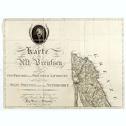
(Single sheet from) Karte von Alt-Preussen enthaltend Ost=Preusen nebst Preussisch Lithauen. . . 1796 bis 1802.
The title section of this important multi-sheet map of Prussia, Lithuania, and Poland, showing territories of present Lithuania (Klaipeda district). With a medallion repr...
Place & Date: Berlin, 1802-1810
Selling price: $300
Sold in 2014
(Key sheet) General Tableau zur Karte von Alt Ost und West Preussen nebst dem aufgenommenen Trigonometrischen Netz. . .
Sheet II with part of Lithuania and the Key of this important multi sheet map of Prussia, Lithuania and Poland.The rare first edition of this important 25-sheet map prepa...
Place & Date: Berlin, 1802-1810
Selling price: $300
Sold in 2014
![[No tittle] Lithuania and Poland. "A.6".](/uploads/cache/30629-250x250.jpg)
[No tittle] Lithuania and Poland. "A.6".
Very detailed map of Lithuania. Show the cities of Tilse, Chavli, Vilna. With parts of Poland. In upper right corner "A.6".Scale 1: 500.000. One sheet of from &...
Place & Date: Paris, 1812-1813
Selling price: $17
Sold in 2012
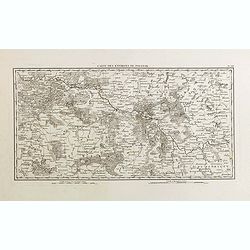
Carte des environs de Polotsk.
Very detailed map taken from the atlas part of the rare work "Mémoires pour servir à L'Histoire de la Guerre entre la France et la Russie, en 1812". Guillaume...
Place & Date: Paris, Barrois L'Aine, 1817
Selling price: $210
Sold in 2015
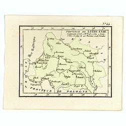
Province de Lithuanie contenant 15 Col. 2 M.on Prof. 2 Sém. 2 Novic. 3 Rés. Et plus de 40 Jésuites.
Rare map of Lithuania from "Atlas Universel indiquant les établissemens des Jésuites: avec la manière dont ils divisent la terre, suivi desévénemens remarquable...
Place & Date: Paris, Ambroise Dupont , 1826
Selling price: $225
Sold in 2017
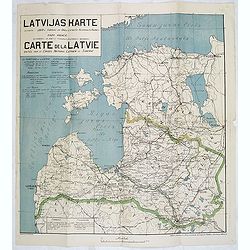
Latvijas Karte. . . Carte de la Latvie editée par le conseil national Latvien en Siberie.
One of the earliest maps showing an independent Latvia, in 1919. Estonia in upper right corner. Prepared by Luit. MantnieksOn July 21, 1919, Latvia and Estonia signed a b...
Place & Date: Latvia, 1919
Selling price: $275
Sold in 2017
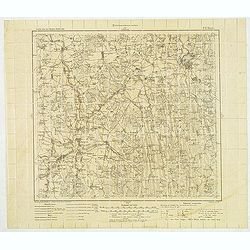
(Military map as paper for stamps of the newly formed Latvia.) No. P. 17 Birze)
The first stamps of Latvia – printed on German military maps almost 100 years ago. Military map with red 5. Kap stamps - the rarer perforated and gummed version, showin...
Place & Date: Riga, Schnaekenburg printing, 1918-1919
Selling price: $210
Sold in 2012