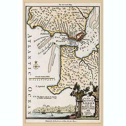
Partie Meridionale du Royaume de Portugal.
Small detailed map encompassing the whole southern half of Portugal. From Atlas Portatif Universel, by Robert de Vaugondy.Page 51 outside border top right. Mary Sponberg ...
Place & Date: Paris, later than 1749
Selling price: $70
Sold in 2012
![Les Ports de, Lisbonne [. . .] Le Detroit de Gibraltar...Cadis](/uploads/cache/90434-250x250.jpg)
Les Ports de, Lisbonne [. . .] Le Detroit de Gibraltar...Cadis
A finely engraved two section map of the Lisbon coast / Setubal area of Portugal and Cadiz / Straights of Gibraltar in Spain. The work contains two elaborate cartouches a...
Place & Date: Paris, ca. 1751
Selling price: $250
Sold in 2008
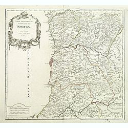
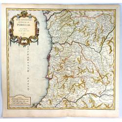
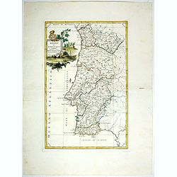
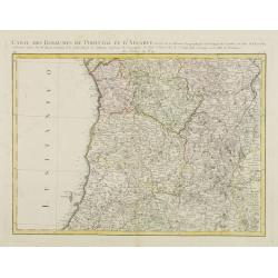
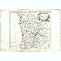
Partie Septentrionale du Royaume de Portugal.
Detailed map encompassing the whole northern half of Portugal from his "Atlas Universel".Gilles Robert de Vaugondy (1688–1766), also known as Le Sieur or Mons...
Place & Date: Paris, 1751
Selling price: $55
Sold in 2011
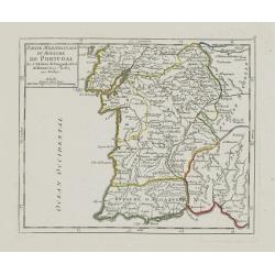
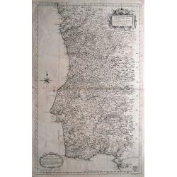
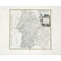
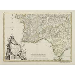
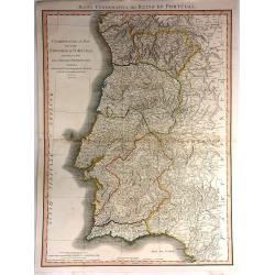
Partie Meridionale du Royaume de Portugal.
Detailed map encompassing the whole southern half of Portugal from his "Atlas Universel".Gilles Robert de Vaugondy (1688–1766), also known as Le Sieur or Mons...
Place & Date: Paris, 1751
Selling price: $45
Sold in 2011
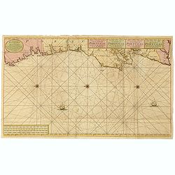
Nieuwe Generale Paskaart van de Cust van PORTUGAL tusschen C: de Finisterre. . .
Decorative chart of the coast of Portugal, from Pontevedra (Spain) to the Cape Saint Vincent (Vila do Bispo). East to the top. More about Van Keulen dynasty [+]
Place & Date: Amsterdam, 1751
Selling price: $800
Sold in 2015
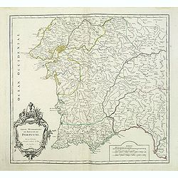
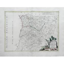
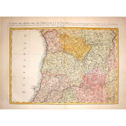
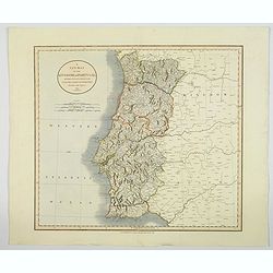
Partie Septentrionale du Royaume de Portugal
A finely engraved map of the northern portion of Portugal by Robert de Vaugondy. It covers northern Portugal from Tui in Spain, southward to Santarem, and inland as far a...
Place & Date: Paris, 1751
Selling price: $57
Sold in 2019
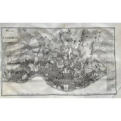
![Plan Du Port De Lisbonne Et Des Costes Voisines.. [Lisbon]](/uploads/cache/23031-250x250.jpg)
Plan Du Port De Lisbonne Et Des Costes Voisines.. [Lisbon]
A well engraved and highly detailed chart of Lisbon harbour with a decorative horizontal panorama along upper part. It shows soundings, anchorage's, channels, shoals, nav...
Place & Date: Paris, 1756
Selling price: $1000
Sold
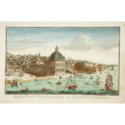
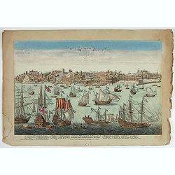
A view of the Palace of the King of Portugal at LISBONE.
One of the lesser-known publishers of optical prints, established in Paris.In the eighteenth and nineteenth centuries there were many popular speciality establishments in...
Place & Date: Paris, ca. 1760
Selling price: $250
Sold in 2017
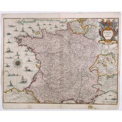
Novissima Regnorum Portugalliae et Algarbiae descriptio.
Map of Portugal. Fine title and scale cartouche. With privilege of the State of Holland. The edition published by Covens and Mortier. Now with their address added.The Ams...
Place & Date: Amsterdam, ca. 1760
Selling price: $200
Sold in 2010
Plan du port de Lisbonne.
Highly detailed chart of the bay of Lisbon by the famous French geographer Nicolas Bellin. Shows the area with numerous forts, towns, and important landmarks along the co...
Place & Date: Paris, ca. 1760
Selling price: $110
Sold in 2012
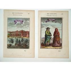
Belem (left) and Portugais (right)
A pair of well defined and decorative 18th century prints. One depicts Mosteiro dos Jeronimos in the Belem section of Lisbon and the other an affluent couple in typical l...
Place & Date: Paris, ca. 1760
Selling price: $50
Sold in 2011
Lisbone Ville Capitale du Royaume de Portugal…
A very RARE panoramic view of the city of Lisbon, including a numbered legend in the lower part : 1-28.The plate, at the joint address of Esnault et Rapilly and Daumont,...
- $1000 / ≈ €936
Place & Date: Paris, c. 1760
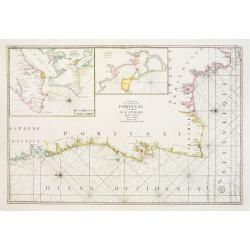
Carte Des Costes De Portugal et de Partie D'Espagne depuis le Cap de Finisterre Jusques au Dêtroit De Gibraltar.
Large scale chart of Portugal engraved by H. van Loon Sculp. With inset of the Bay of Lisbon and Cadiz.With rhumb lines radiating across the chart. Published by the Depot...
Place & Date: Paris 1762
Selling price: $700
Sold
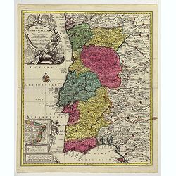
Le Royaume de Portugal divisé en cinq grandes Provinces...
Rare and large map of entire Portugal, extending from Vigo in the North to Cadiz in the South. Highly decorative map, superbly engraved, with a large title cartouche, a s...
Place & Date: Paris, 1762
Selling price: $500
Sold in 2011
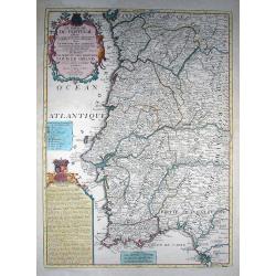
Le Portugal et ses Frontieres avec l'Espagne. . .
Impressive large-scale map of Portugal with the border areas of Spain, published by the Depot de la Marine. Highly detailed filled with information on the topography, fo...
Place & Date: Paris, 1762
Selling price: $130
Sold in 2014
Regna Portugalliae et Algarbiae. . .
A large and imposing map of the Kingdoms of Portugal and the Algarves, beautifully rendered by tobias Lotter during the 18th century. Relief is shown pictorially with riv...
Place & Date: Augsberg, ca 1762
Spain and Portugal.
Uncommon miniature map of Portugal, engraved by J. Gibson for "A New General and Universal Atlas Containing Forty five Maps by Andrew Dury".This miniature atlas...
Place & Date: London, 1761-1763
Selling price: $25
Sold in 2019
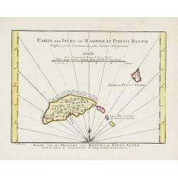
Carte des Isles de Madere et Porto Santo.
An uncommon issue of this very nice map of the Island of Madera and Porto Santo.With French text in title cartouche and an additional title in Dutch underneath the map.
Place & Date: Amsterdam, 1773
Selling price: $90
Sold
L'Estremadura di Portogallo Alentejo, ed Algarve. . .
Map of the regions of Algarve and Alentejo of Southwestern Portugal by Antonio Zatta. The city of Lisbon is depicted along the western coast, as are the other towns, vill...
Place & Date: Venice, 1775
Selling price: $100
Sold in 2010
Regno Di Portogallo.
Map from "Atlas Novissimo" printed in Venice between 1776 and 1785. The map was issued in Zatta's Atlas Novissimo a monumental four volume work and one of the l...
Place & Date: Venise, 1775
Selling price: $62
Sold in 2018
![Il Portogallo Cioé le provincie . . . [with] L'Estremadura Di Portogallo alentejo . . .](/uploads/cache/39014-250x250.jpg)
Il Portogallo Cioé le provincie . . . [with] L'Estremadura Di Portogallo alentejo . . .
Two maps of north and South Portugal from "Atlas Novissimo" printed in Venice between 1776 and 1785. The map was issued in Zatta's Atlas Novissimo a monumental ...
Place & Date: Venise, 1775
Selling price: $70
Sold in 2017
Il Portogallo Cioe le Provincie di Entredouro, e Minho, Traz-os-Montes, e Beira Di Nuova Projezione. . .
Map of the provinces of Minho, Biera, Tras-os-Montes e Alto Duoro and Beira, of northern Portugal, by Antonio Zatta. Towns, villages, forests, mountains and rivers of the...
Place & Date: Venice, 1776
Selling price: $100
Sold in 2010
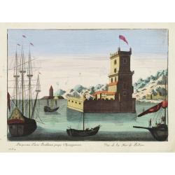
Prospectus Turris Bethlemi prope Ulyssipponem - Vue de la Tour de Bellem.
Optical view of the Belém Tower located in the Belém district of Lisbon, Portugal.In the eighteenth and nineteenth centuries there were many popular speciality establis...
Place & Date: Italy 1780
Selling price: $135
Sold

Vue Perspective du Palais du Duc d'Aveiro a Lisbonne.
Perspective view of the Palace of the Duke of Aveiro in Lisbon. A well-known publisher of optical prints, established in rue St.Martin in Paris.In the eighteenth and nine...
Place & Date: Paris, 1780
Selling price: $50
Sold in 2021
A Plan of the City of Lisbon with the Harbour, Forts, Depths of Water and Country adjacent.
A lovely small plan of the city and immediate surrounds of the Portuguese capitol, complete with a mileage scale, compass rose and a decorative title vignette in the lowe...
Place & Date: London, ca 1780
Selling price: $25
Sold in 2021
Carte des Royaumes de Portugal et D\'Algarve..
Map of the northern part of Portugal prepared by Giovanni Antonio Bartolomeo Rizzi Zannoni, one of the leading cartographers of the late 18th century, as well as being an...
Place & Date: Paris, ca 1783
Selling price: $80
Sold in 2010
Mapa dos Reynos de Portugal e Algarve. . .
Map of the southern part of Portugal, including part of Spain and Gibraltar. The large decorative title cartouche presents the coat of arms surmounted by a crown, a repre...
Place & Date: Paris, ca 1783
Selling price: $75
Sold in 2020
Carte des Royaumes de Portugal et D'Algarue.
Detailed engraved map of the northern part of Portugal including cities, towns, rivers, lakes, forests and mountains. Giovanni Antonio Bartolomeo Rizzi Zannoni (1736 - 1...
Place & Date: Paris, 1783
Selling price: $15
Sold in 2015
Partie Septentrionale du Royaume de Portugal. . .
Detailed map encompassing the whole northern half of Portugal, with part of the neighboring Spain.Venetian edition of the map by Bellin, to whom Santini gives credit in t...
Place & Date: Venice, 1776 - 1784
Selling price: $25
Sold in 2022
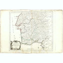
Partie Septentrionale.. Partie Meridionale du Royaume de Portugal..
A detailed map of southern part of Portugal showing the roads, prepared by N.Bellin.Venetian edition of the map by Bellin, to whom Santini gives credit in the cartouche.F...
Place & Date: Venice, 1776 - 1784
Selling price: $60
Sold in 2015
![[2 maps] Partie Septentrionale... & Partie Meridionale du Royaume de Portugal...](/uploads/cache/81817-250x250.jpg)
[2 maps] Partie Septentrionale... & Partie Meridionale du Royaume de Portugal...
A pair of large maps of Portugal with bordering Spanish areas. From Fisterra, Vigo and Pontevedra until Cadiz. Extends east until Salamanca and Sevilla. Very detailed, fi...
Place & Date: Venice, 1784
Selling price: $100
Sold in 2018
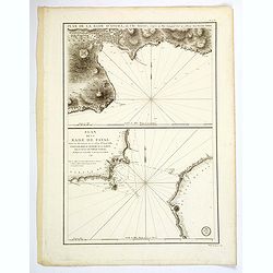
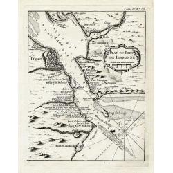
Plan de la Rade d'Angra, en L'Ile Tercere. . . / Plan de la Rade de Fayal. . .
A twin chart of the two harbours of Angra and Fayal (Faial) in the Azores, surveyed by the Depot General de la Marine in Paris towards the end of the eighteenth century. ...
Place & Date: Paris, ca 1791
Selling price: $100
Sold in 2019
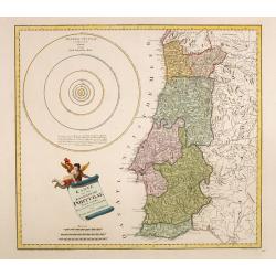
Karte von dem Konigreiche Portugal.
An attractive map of Portugal, including a representation of the solar system in the upper left-hand corner. With a charming title cartouche held by a cherub in the lower...
Place & Date: Vienna, 1795
Selling price: $220
Sold in 2016
Chorographical Map of the Kingdom of Portugal divided into its Grand Provinces
A very large, pleasant map of Portugal, with roads, provinces, settlements and towns published by William Faden in 1797, Filled with detail including mountains.William Fa...
Place & Date: London, 1797
Selling price: $40
Sold in 2016
Plan von Lissabon.
Scarce city map of Lisbon. With 54 places named in the panel on the right. Published in Merkwürdigkeiten der Welt by Schrämbl.
Place & Date: Vienna, 1806
Selling price: $70
Sold in 2019
A New Map of the Kingdom of Portugal.
A fine and detailed map of Portugal by John Cary, with the various provinces in pale wash color. Showing mountains, roads, rivers and numerous village and towns. Interest...
Place & Date: London, 1819
Selling price: $65
Sold in 2020
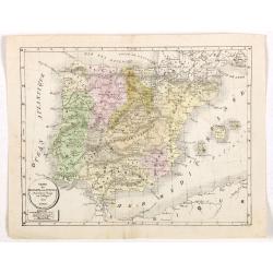
Carte de l'Espagne et du Portugal dréssée pour l'usage des Collèges 1822.
Uncommon lithographed map of Spain and Portugal taken from " Atlas Géographique. Géographie moderne actuelle. Pour l'usage des Collèges."
Place & Date: Paris, 1822
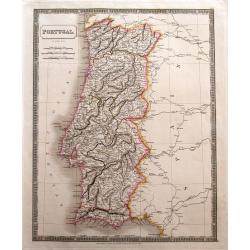
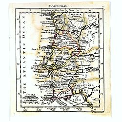
Portugal.
Large and detailed steel-engraved map of Portugal with original outline handcoloring. A fine map, nicely engraved. Extends to show the Spanish cities of Vigo, Truxillo, C...
Place & Date: London, 1829
Selling price: $46
Sold in 2014
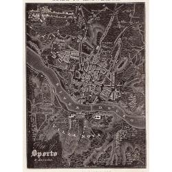
Oporto.
A distinctive woodblock engraved map of Oporto where the printing is reversed - white on black. The map was published in London in 1832 in William Pinnock's "The Gui...
Place & Date: London, 1832
Selling price: $55
Sold in 2012
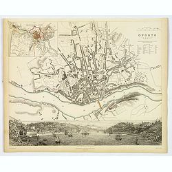
Oporto.
An appealing plan of the second largest Poruguese city of Oporto, famed for giving its name to Port wine. There is a detailed town plan, plus a small table of notes to as...
Place & Date: London, 1833
Selling price: $40
Sold in 2019