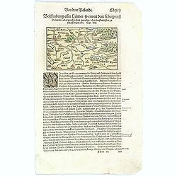
Beschreibung aller Laender so Etwann dem Koenigreich Poland...
An attractive, small wood cut map of Poland by Sebastian Münster, from his popular 'Cosmography' atlas. Text below and verso is German. With a small colored illustration...
Place & Date: Basle, ca. 1580
Selling price: $60
Sold in 2017
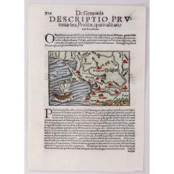
De Germania Descriptio Prutentiae Seu, Prussiae, Quam Alii Uo.
A fine Münster woodcut map of Prussia. Features a large sailing ship in the sea and many little animals. One of the largest cities is Pomern.Sebastian Münster (1488–1...
Place & Date: Basel, 1580
Selling price: $55
Sold in 2016
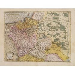
Poloniae, Lituaniaeq descriptio.
Fine general map of Poland, the first plate. Based on the now lost map of Waclaw Grodecki (1588). Shows the Polish kingdom near its greatest territorial limits, stretchin...
Place & Date: Antwerp, 1584
Selling price: $700
Sold in 2013
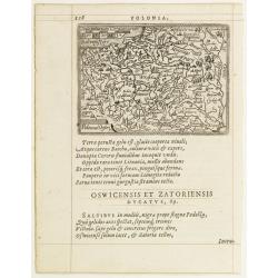
Poloniae Descrip.
Map of Poland from the first Latin edition and the only not issued in an oblong format of this illustrated treatise of geography, which is considered as the first modern ...
Place & Date: Antwerp, 1585
Selling price: $350
Sold in 2009
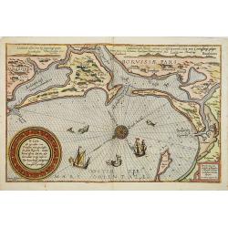
De caerte ofte zee cuften van Pruijssen, met zijne haffen ofte groote Rivieren. . .
A detailed chart of part of the coastline of Poland and the city of Danzig (Gdansk). Decorated by a title, scale and descriptive cartouche, a compass rose, several vessel...
Place & Date: Leiden, Plantijn, 1585
Selling price: $3600
Sold
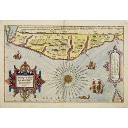
Caerte van de zee custe vant Landt te Pomere. . .
A detailed chart of part of the coastline of Poland and the city of Pomeren, and part of the Danish island of Bornholm. Decorated by a title and scale cartouche, a compas...
Place & Date: Leiden, Plantijn, 1585
Selling price: $2400
Sold
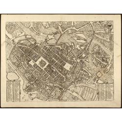
Wratislavia
Beautiful birdeye view of Wroclaw (Breslau) in Lower Silesia, Poland by Braun & Hogenberg from "Civitated Orbis Terrarum". Dated in plate 1587. ...
Place & Date: Cologne, 1587
Selling price: $700
Sold in 2009
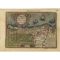
Pomeraniae wandalicae regnionis tipus.
Nice map features Pomerania and is based on the Peter Artopaus map published in 1550 by Sebastian Munster. With a nice title cartouche and 2 monsters in the sea. Latin te...
Place & Date: Antwerp, 1588
Selling price: $120
Sold
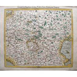
Landtafel des Ungerlands, Polands, Reussen, Littaw, Walachen und Bulgaren.
Early edition Munster's map of Poland, Lithuania, the Ukraine, Moscovy and the Balkans, extending from Prussia, Vilna and Smolensky in the north to Bosnia, Bulgaria, Cons...
Place & Date: Basle, 1588
Selling price: $170
Sold in 2014
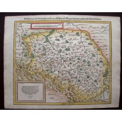
Schlesia nach aller Gelegenheit / in stetten / wassern und bergen / mit sampt andern anstossenden Laendern.
An attractive woodblock map centered on Bresla (Wroclaw) with pictorial representations of forests, towns and mountains. The region is Silesia, Poland. German text and il...
Place & Date: Basle, S.H. Petrie, 1588
Selling price: $120
Sold in 2021