Browse Listings in Europe > Greece > Greek Islands
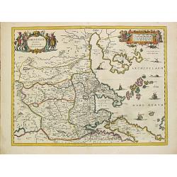
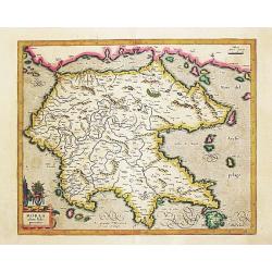
Thessaliae accurata descriptio.
A map of northeast of Greece in classical times by the hand of Johannes Laurenberg appeared in part V of Johannes Janssonius? ?Atlantis Majoris?.Embellished with two deco...
Place & Date: Amsterdam, 1650-57.
Selling price: $260
Sold
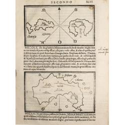
Charusa, Zinara Levita / Micole / (on verso) Stapodia and Nicaria.
Benedetto Bordone (1460-1531), cartographer and engraver. Published in 1528 his islands book, 'Isolario'.Three maps from Bernadetto Bordone?s ?Isolario?.
Place & Date: Venice, 1532
Selling price: $150
Sold
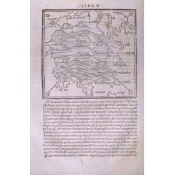
(Morea / Peloponnese peninsula)
Very early map of the Peloponnese peninsula, naming several towns and smaller islands. Published in Bordone's important "Isolario". Italian text below the map a...
Place & Date: Venice, c1534
Selling price: $110
Sold in 2014
![[Map of Morea]](/uploads/cache/31508-250x250.jpg)
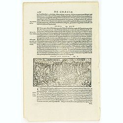
[Map of Morea]
Page with an early representation of the Greek Island of Morea. This text page with a fine wood block printed map is from the rare work "C. Iulii Solini Polyhistor, ...
Place & Date: Basle, Michael Isengrin, 1544
Selling price: $150
Sold in 2013
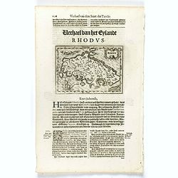
![[Map of Rhodes]](/uploads/cache/31507-250x250.jpg)
[Map of Rhodes]
Page with an early representation of the Greek Island of Rhodes. This text page with a fine wood block printed map is from the rare work "C. Iulii Solini Polyhistor,...
Place & Date: Basle, Michael Isengrin, 1544
Selling price: $60
Sold in 2018
![[Crete] EL VERO ET NVOVO DISEGNO, DI TVTTA LA ISOLA, DI CANDIA.](/uploads/cache/23788-250x250.jpg)
[Crete] EL VERO ET NVOVO DISEGNO, DI TVTTA LA ISOLA, DI CANDIA.
Fine map of Crete. No further states are recorded.Engraved by Paolo Forlani (active 1561-1577). Title in banner in top. In lower right corner a cartouche including the hu...
Place & Date: Venice 1564
Selling price: $2500
Sold in 2010
Vogliono alcuni l'isola di Corfu fosse prima ..
Fine map of the island of Kerkyra (Corfu), based on a map of the French artist Jacques Prevost. The present edition by Fernando Bertelli (ascribed by D.Woodward to Paolo ...
Place & Date: Venice, 1564
Selling price: $2100
Sold in 2010
![[Versalis Lib I]](/uploads/cache/38533-250x250.jpg)
[Versalis Lib I]
One text page with Latin text with reference to Delos, Rhodes, Alone, Thera/ Sicilia and Therasia, illustrated with a fancy wood cut map (130 x 145 mm) with three dimensi...
Place & Date: Basle, ca. 1564
Selling price: $25
Sold in 2018
Tabula Thraciae. (Bulgaria, northern Greece, and the European part of Turkey)
Double-page woodcut Ptolemaic-style map by Sebastian Münster figuring Thrace, roughly corresponding to modern day Bulgaria, northern Greece, and the European part of Tur...
Place & Date: Basle, Henri Petri, 1571
Selling price: $150
Sold in 2018
![[Rhodus].](/uploads/cache/41985-250x250.jpg)
[Rhodus].
Woodcut Ptolemaic-style map by Sebastian Münster figuring Rhodes Island, published in the edition of Strabo by Henri Petri in 1571."Strabonis rerum geographicarum&q...
Place & Date: Basle, Henri Petri, 1571
Selling price: $50
Sold in 2018
![[Lesbos].](/uploads/cache/41986-250x250.jpg)
[Lesbos].
Woodcut Ptolemaic-style map by Sebastian Münster figuring Lesbos Island, published in the edition of Strabo by Henri Petri in 1571."Strabonis rerum geographicarum&q...
Place & Date: Basle, Henri Petri, 1571
Selling price: $55
Sold in 2018
![[Creta].](/uploads/cache/41987-250x250.jpg)
[Creta].
Woodcut Ptolemaic-style map by Sebastian Münster figuring Crete Island, published in the edition of Strabo by Henri Petri in 1571."Strabonis rerum geographicarum&qu...
Place & Date: Basle, Henri Petri, 1571
Selling price: $60
Sold in 2018
![[Cephaelenia].](/uploads/cache/41988-250x250.jpg)
[Cephaelenia].
Woodcut Ptolemaic-style map by Sebastian Münster figuring Cephalonia or Kefalonia Island, published in the edition of Strabo by Henri Petri in 1571."Strabonis rerum...
Place & Date: Basle, Henri Petri, 1571
Selling price: $50
Sold in 2018
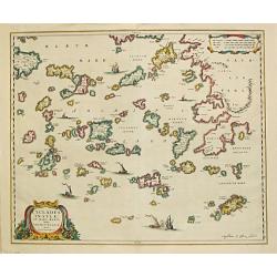
Tabula Europae X - (Greek Islands)
One of the earliest maps of the Greek Islands. From Girolamo Ruscelli's edition of "Ptolemy's Geographia". The woodcut map is drawn on the trapezoidal projectio...
Place & Date: Venice, 1575
Selling price: $130
Sold in 2013
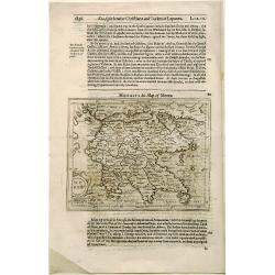
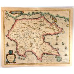
Morea Penisola.
One of the earliest separate maps of Morea. Includes decorative cartouche and compass rose. Nice wide margin example, with Italian text.From: L'isole piu famose del mondo...
Place & Date: Padova 1576
Selling price: $100
Sold
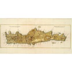
Candia feu Creta insula.
Very early map of the island of Crete. From his Cosmographia, that great compendium of Renaissance knowledge. An exciting print.Sebastian Münster was born in Nierder-Ing...
Place & Date: Basle 1550-1580
Selling price: $50
Sold in 2008
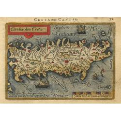
Candia olim Creta
Nice miniature map of the island that shows several place names and the mythological Labyrinth where the Minotaur was confined. The map is beautifully engraved with stipp...
Place & Date: Antwerp, 1588
Selling price: $160
Sold
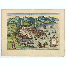
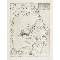
Chios.
The engraving shows the seaport of Chora, the capital of Chios, as seen from the east in a bird's-eye view.
Place & Date: Cologne, ca 1588
Selling price: $420
Sold in 2018
![[De Graecia.- Euböa or Evia ]](/uploads/cache/32552-250x250.jpg)
[De Graecia.- Euböa or Evia ]
On verso an early wood block printed map of the island of Euböa (Evia) in Greece. Below a portrait of Aristote. From a Latin text edition of his Geographia , that great ...
Place & Date: Basle, 1550-1590
Selling price: $20
Sold in 2017
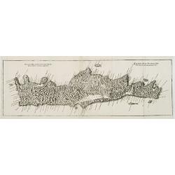
Candia seu Creta insula.
On recto an early map of the Island of Crete (77x156mm.). From a Latin text edition of his Geographia , that great compendium of Renaissance knowledge.Read more [+]
Place & Date: Basle, 1550-1590
Selling price: $20
Sold in 2020
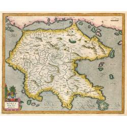
Morea olim Peloponnesus.
Peloponnisos by Mercator. Latin text on verso.
Place & Date: Amsterdam, 1595
Selling price: $300
Sold in 2009
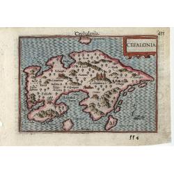
Cefalonia
Very fine early miniature map of the Greek island of Cefalonia (Cephalonia), this map is from the first edition of the Langenes atlas, (later well known under the name of...
Place & Date: Middelburg, 1598
Selling price: $60
Sold in 2010
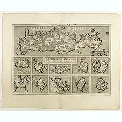
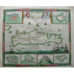
Archipelagi Insularum Aliquot Descrip.
Very decorative map showing map of Crete and 10 insets of Greek islands: Candia, Metellino, Santorini, Milo, Rodus, Scio, etc.Dare to go in Black. All early maps are prin...
Place & Date: Antwerp, 1598
Selling price: $300
Sold in 2021
![Golfo di Lepanto. [Map of the Gulf of Nafpaktos]](/uploads/cache/45227-250x250.jpg)
Golfo di Lepanto. [Map of the Gulf of Nafpaktos]
Very rare map of Gulf of Nafpaktos, known as Lepanto. It is named for Naupaktos, an important Athenian naval station in the Peloponnesian war. As a strategically crucial ...
Place & Date: Venice, Giacomo Franco, 1598
Selling price: $250
Sold in 2023
![Scharpanto [Map of Scharpantos]](/uploads/cache/45234-250x250.jpg)
Scharpanto [Map of Scharpantos]
Very rare map of Karpathos Island published in the first edition of "Viaggio da Venetia, a Costantinopoli. Per Mare, e per Terra, & infieme quello di Terra Santa...
Place & Date: Venice, Giacomo Franco, 1598
Selling price: $450
Sold
![Famagosta [Plan of Famagusta]](/uploads/cache/45239-250x250.jpg)
Famagosta [Plan of Famagusta]
Very rare plan of Famagusta, situated east of Nicosia and possesses the deepest harbour of the island. During the medieval period (especially under the maritime republics...
Place & Date: Venice, Giacomo Franco, 1598
Selling price: $375
Sold in 2020
![[View of Navarino]](/uploads/cache/45229-250x250.jpg)
[View of Navarino]
Very rare view of Navarino published in the first edition of "Viaggio da Venetia, a Costantinopoli. Per Mare, e per Terra, & infieme quello di Terra Santa. Da Gi...
Place & Date: Venice, Giacomo Franco, 1598
Selling price: $135
Sold in 2022
![[View of Napoli Romania]](/uploads/cache/45231-250x250.jpg)
[View of Napoli Romania]
Very rare view of Nafplion published in the first edition of "Viaggio da Venetia, a Costantinopoli. Per Mare, e per Terra, & infieme quello di Terra Santa. Da Gi...
Place & Date: Venice, Giacomo Franco, 1598
Selling price: $200
Sold in 2022
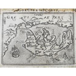
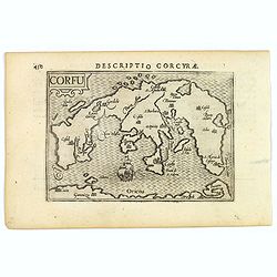
Corcyra vel Corfu
Unusual edition of this early miniature map of Corfu. With a sailing ship and a sea-monster. Latin title above the map.
Place & Date: Antwerp, ca. 1600
Corcyra vel Corfu
Unusual edition of this early miniature map of Corfu. With a sailing ship and a sea-monster. Latin title above the map.
Place & Date: Antwerp, ca. 1600
Morea olim Peloponnesus.
Gerard Mercator's map of the Greece's Peloponnesus peninsula called and labelled Morea. A few of the other smaller islands appear included the larger Cerigo (today's Cyth...
Place & Date: Amsterdam 1606
Selling price: $160
Sold
Corfu.
A lovely miniature map of the Greek island of Corfu, published by Petrus Bertius, in Amsterdam at the beginning of the seventeenth century. The map is orientated with nor...
Place & Date: Amsterdam, 1606
Selling price: $65
Sold in 2023
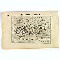
Candia.
An attractive miniature map of Crete by Petrus Bertius, published in Amsterdam at the beginning of the seventeenth century. The sea is hatched, it has a strap-work title ...
Place & Date: Amsterdam, 1606
Selling price: $40
Sold in 2023
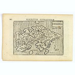
Cefalonia.
A fine miniature map of Cephalonia, the largest of the Ionian islands in western Greece, published by Petrus Bertius in Amsterdam early in the seventeenth century. The ma...
Place & Date: Amsterdam, 1606
Selling price: $50
Sold in 2021
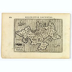
Zante Insula.
A fine miniature map of Zante (Zakynthos), the third largest of the Ionian islands in western Greece, published by Petrus Bertius in Amsterdam early in the seventeenth ce...
Place & Date: Amsterdam, 1606
Selling price: $50
Sold in 2021
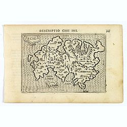
Scio.
A fine miniature map of Scio (Chios) in the Aegian Sea, in eastern Greece, published by Petrus Bertius in Amsterdam early in the seventeenth century. The lovely map and h...
Place & Date: Amsterdam, 1606
Selling price: $50
Sold in 2021
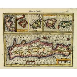
Candia, Corfu Zante, Milo, Nicsia, Scarpanto.
Early map of Crete, Corfu, Zante, Milos, Naxos and Scarpanto. From the first French-text edition of Jodocus Hondius' Atlas Minor.Shortly after the publication of the big ...
Place & Date: Amsterdam, 1608
Selling price: $160
Sold in 2010
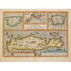
CRETA - CORSICA - INSULAE MARIS IIONI - SARDINA.
Abraham Ortelius(1527-98), Dutch cartographer and publisher of the first modern atlas, ' Theatrum Orbis Terrarum' in 1570. Editions till 1612. Also an atlas of ancient ca...
Place & Date: Antwerp, Robert Bruneau, 1609
Selling price: $800
Sold
Candia / Candie.
A miniature map of Crete. Title cartouche on the lower right corner. Surrounding the island, two sea monsters and a ship are depicted.First published in 1598 in his Caert...
Place & Date: Amsterdam/ Frankfurt, 1609
Selling price: $230
Sold in 2012
![Scio. [Chios]](/uploads/cache/23064-250x250.jpg)
Scio. [Chios]
A miniature map of Scio, the Italian name for the Greek Island of Chios.First published in 1598 in his Caert-Thresoor, the plates were executed by the most famous engrave...
Place & Date: Amsterdam/Frankfurt 1609
Selling price: $65
Sold
Morea olim Peloponnesus. per Gerardum Mercatorum.
Gerard Mercator's ' Atlas sive Cosmographica' was augmented and published in 1606 by Jodocus Hondius.Gerard Mercator's map of the Peloponesus, published by Jodocus Hondiu...
Place & Date: Amsterdam, 1609
Selling price: $200
Sold in 2018
Morea olim Peloponnesus.
Early map of Peloponnesus, Greece.
Place & Date: Amsterdam, 1610
Selling price: $120
Sold in 2014
Rhodi.
One of the earliest separate maps of Rhodos. Includes decorative cartouche, sea monsters, sailing ship, etc. Nice wide margin example, with Italian text. A decorative com...
Place & Date: Padova, (1572-) 1620
Selling price: $110
Sold
Rhodi.
Small map illustrating the island of Rhodes, oriented with West on top and surrounded by text in Dutch.Nicolaes de Clerck (de Klerc) was active as engraver and publisher ...
Place & Date: Amsterdam, Cloppenburch, 1621
Selling price: $100
Sold in 2008
Rhodi.
Small map illustrating the island of Rhodes, oriented with West on top and surrounded by text in Dutch.Nicolaes de Clerck (de Klerc) was active as engraver and publisher ...
Place & Date: Amsterdam, Cloppenburch, 1621
Selling price: $90
Sold in 2018
Morea.
The rare Samuel Purchas' edition of the Mercator/Hondius Atlas Minor atlas map. Early map of Peloponnesus, Greece published in his famous collection of voyages His Pilgri...
Place & Date: London 1625
Selling price: $240
Sold in 2013
Candia, Corfu, Zante, Milo, Nicsia, Scarpanto.
The rare Samuel Purchas' edition of the Mercator/Hondius "Atlas Minor" atlas map. Early map of Crete, Greece. With descriptive text in English on both sides. Si...
Place & Date: London, 1625
Selling price: $350
Sold in 2011
Morea olim Peloponnesus.
Gerard Mercator's map of the Greece's Peloponnesus peninsula called and labeled Morea. A few of the other smaller islands appear included the larger Cerigo (today's Cythe...
Place & Date: Amsterdam, 1628
Selling price: $65
Sold in 2018
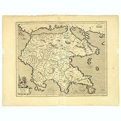
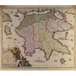
![[Lot of 7 maps/ views of Achaia, Greece.] Achaiae Nova accurata Descriptio. Autore L. Laurenbergio.](/uploads/cache/20638-(1)-250x250.jpg)
[Lot of 7 maps/ views of Achaia, Greece.] Achaiae Nova accurata Descriptio. Autore L. Laurenbergio.
Johannes Laurenberg’s uncommon and very decorative map of Achaia. Embellished with two large cartouches. Johannes Janssonius, the great rival of Willem Blaeu, was the s...
Place & Date: Amsterdam, c. 1630
Selling price: $140
Sold in 2022
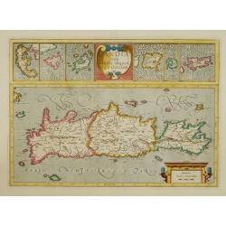
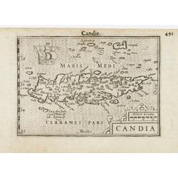
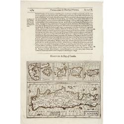
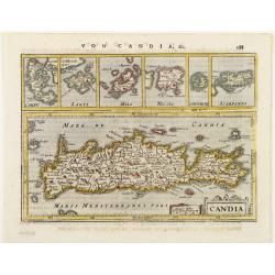
Candia cum insulis aliquot..
Early map of Crete, Greece. With inset maps in top of Corfu, Zante, Milo, Nicosia, Santorini and Scarpanto.
Place & Date: Amsterdam 1633
Selling price: $325
Sold
Morea olim Peloponensis.
A small map of the Peloponnesus decorated with a strapwork title cartouche. Latin text on verso.
Place & Date: Amsterdam 1634
Selling price: $120
Sold
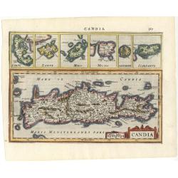
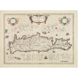
Candia
Map of the island with smaller inset maps above: Corfu, Zante, Milo, Nicsia, and Scarpanto. Strapwork title cartouche and Latin text on verso.
Place & Date: Amsterdam 1634
Selling price: $140
Sold
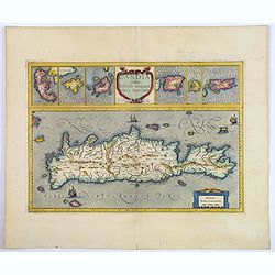
Candia cum Insulis aliquot circa Graeciam.
An attractive (if rather inaccurate) map of Crete, with insets of the islands of Corfu, Zante, Milos, Nicsia, Santorini, and Scarpanto.
Place & Date: Amsterdam, ca 1636
Selling price: $200
Sold in 2018
Candia.
Detailed miniature map of Crete, with 6 inset plans of other Greek islands on top. From a German text edition of his Atlas Minor. Engraved by Petrus Kaerius.
Place & Date: Amsterdam (1628) 1648
Selling price: $50
Sold
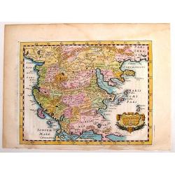
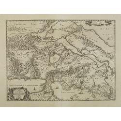
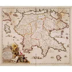
Macedonia Thessalia Epirus.
Fine detailed map of Macedonia by Briet. Decorated with strapwork cartouche. Philippe Briet (1601 - 1668) was a French Jesuit priest, a writer and a mapmaker. His “Par...
Place & Date: Paris, 1649
Selling price: $30
Sold in 2013
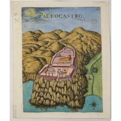
Paleocastro.
A copper engraved view of the Castle of Paleokastro, near Iraklion from Marco Boschini's "Il Regno tutto di Candia”. Marco Boschini, [1613-78] was a Venetian paint...
Place & Date: Venice, 1651
Selling price: $15
Sold in 2022
Candia, olim Creta.
One of the most beautiful ever produced maps of Crete.
Place & Date: Amsterdam 1655
Selling price: $300
Sold
Cyclades Insulae In Mari Aegaeo, hodie Archipelago.
Johan Blaeu succeeded his father Willem when the latter died in 1638. Johan led the Blaeu firm to its greatest achievement, the ' Atlas Maior' in 12 parts, the greatest a...
Place & Date: Amsterdam, 1659
Selling price: $400
Sold
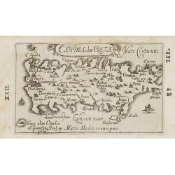
Genuina delineatio insulae Cretae..
A beautifully engraved map of Crete.
Place & Date: Frankfurt 1660
Selling price: $250
Sold
Genuina delineatio insulae Cretae..
A beautifully engraved map of Crete.
Place & Date: Frankfurt, 1660
Selling price: $200
Sold in 2008
Attica Megarici, Corinthiaca, Boeotia, Phocis Locri.
Fine copperplate engraving of Attica and the surrounding regions with the cities of Athens, Thebes, Opus, and Corinth accentuated. The map is graphically engraved to illu...
Place & Date: Amsterdam 1660
Selling price: $50
Sold in 2009
![[Lot of 5 maps of Greece]. Candia olim Creta.](/uploads/cache/IMG_0748-250x250.jpg)
[Lot of 5 maps of Greece]. Candia olim Creta.
Johannes Blaeu's attractive map of Crete. Johan Blaeu succeeded his father Willem when the latter died in 1638. Johan led the Blaeu firm to its greatest achievement the...
Place & Date: Amsterdam, 1660
Selling price: $400
Sold in 2023
![[Lot of 3 maps] Candia olim Creta.](/uploads/cache/IMG_9432-250x250.jpeg)
[Lot of 3 maps] Candia olim Creta.
Johannes Blaeu's attractive map of Greta. Johan Blaeu succeeded his father Willem when the latter died in 1638. Johan led the Blaeu firm to its greatest achievement the '...
Place & Date: Amsterdam, c. 1660
Selling price: $155
Sold in 2022
Creta
A small historical map of Crete with a simple strapwork title cartouche. The map is based on the cartography of Ubbo Emmius, who worked for Hondius and Jansson, and engra...
Place & Date: Amsterdam 1661
Selling price: $80
Sold in 2014
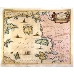
Maris Aegaei Quod hodie Archipelago Nuncupatur, Pars Septentrionalis.
Fine copperplate map featuring the Aeagean Islands of Greece. The map is decorated by a pleasant figural title cartouche and seven detailed ships in the seas. The cartogr...
Place & Date: Amsterdam, 1663
Selling price: $275
Sold in 2015
Candia olim Creta. . .
Charming little map of Crete made by Gabriel Bucelin (1599-1681). Bucelin was a Swiss genealogist and an author of several books and a number of manuscript maps of German...
Place & Date: Ulm, Johannes Görlin, 1658-1664
Selling price: $200
Sold in 2008
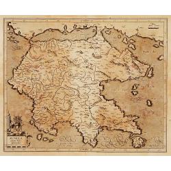
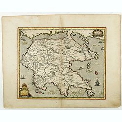
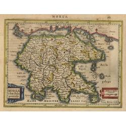
Morea Olim Peloponnesus
An attractive map of the Peloponnesos peninsula in southern Greece that was called Morea until well into the 19th century. The narrow isthmus between the mainland and the...
Place & Date: Amsterdam, 1666
Selling price: $120
Sold in 2016
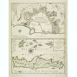
Candie ville metropolitaine de l'Isle de même nom . . . Isle de Candie . . .
Two maps on one sheet: In top Crete's metropolitan town Heraklion with a descriptive text inside the town "Candie ville metropolitaine de méme nom soûmise au grand...
Place & Date: Paris, 1667
Selling price: $425
Sold in 2012
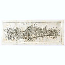
Insula Candia Ejusque Fortificatio.
Nice map of Crete (candia) with inset maps of Canea, Candia, Suda, Thise, Retimo and Spina Longa in an unusual fresh color.The map is in a strictly contemporary coloring ...
Place & Date: Amsterdam, 1670
Selling price: $710
Sold in 2013
Carta del Regno di Candia.
Scarce map of Crete from "Historia di Leopoldo Cesare" by Galeazzo Gualdo Priorato. The map is after a map by Marco Boschini but less detailed in island place-n...
Place & Date: Vienna, 1670
Selling price: $100
Sold in 2020
Peloponnesus Hodie Moreae regnum..
Decorative map of the Greece island Peloponnesus.Unfortunately with some holes and browning. Can be restored.Sold as is.
Place & Date: Amsterdam 1680
Selling price: $115
Sold
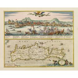
Candia./ Insula Candia olim Creta.
Richly engraved work, one of the most beautiful ever produced maps of Crete.Upper part showing the Turkish siege of the town of Candie.
Place & Date: Amsterdam, 1680
Selling price: $1500
Sold in 2009
Peloponnesus hodie Morea..
Detailed map of the southern part of Greece, including Peloponnesus, Zakinthos, and Kefallinia. Good detail throughout. Large (colored) cartouche depicting a mythical lio...
Place & Date: Amsterdam ca.1680
Selling price: $100
Sold in 2014
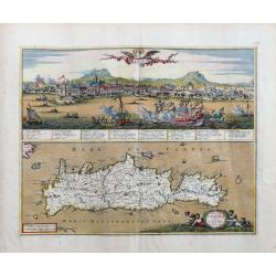
Insula Candia olim Creta.
Superbly engraved and highly beautiful map of Crete, with a large panorama of Heraklion during the Turkish siege on top. The view is very detailed with a number of shi...
Place & Date: Amsterdam, c1680
Selling price: $650
Sold in 2023
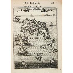
Isle de Stampalia.
Alain Manneson Mallet (1603-1706) published in 1683 his ' Description de l' Univers' in 5 volumes. In 1686 a German edition appeared. A map depicting the island of Stampa...
Place & Date: Paris, 1683
Selling price: $55
Sold
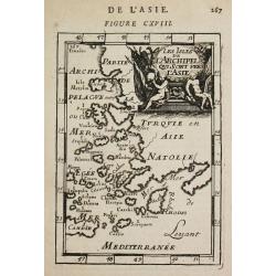
Les Isles de l'Archipel qui sont vers l'Asie.
Alain Manneson Mallet (1603-1706) published in 1683 his ' Description de l' Univers' in 5 volumes. In 1686 a German edition appeared.A map from Alain Manesson Mallet's 'D...
Place & Date: Paris, 1683
Selling price: $55
Sold
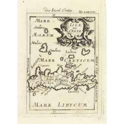
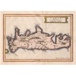
Isle de Crete.
A charming late 17th century map of the Island of Crete. By Allain Manneson Mallet (1630-1706), a well traveled military engineer and geographer who worked in 17th centur...
Place & Date: Frankfurt, 1684
Selling price: $120
Sold in 2011
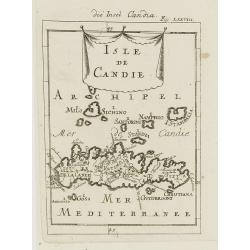
Isle de Candie.
A charming late 17th century French map of Crete and surrounding islands.By Allain Manneson Mallet (1630-1706), a well traveled military engineer and geographer who worke...
Place & Date: Frankfurt, 1684
Selling price: $50
Sold in 2009
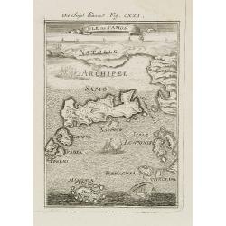
Isle de Samos.
A charming late 17th century map of the Samos Island. Samos is a Greek island in the North Aegean sea, south of Chios, north of Patmos and the Dodecanese, and off the Ion...
Place & Date: Frankfurt, 1684
Selling price: $50
Sold in 2010
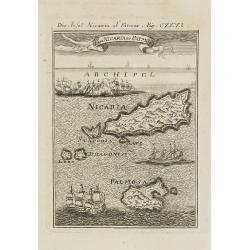
I. de Nicaria et Patmos.
A charming late 17th century map of the Island of Nicaria and Patmos. Located on the eastern borderline of the Aegean Sea, Patmos is the northernmost island of the Dodeca...
Place & Date: Frankfurt, 1684
Selling price: $50
Sold in 2011