Browse Listings in Europe > France > France Cities

Plan de Besancon. Capitalle du Compté de Bourgogne.
A rare plan of Besancon in the Bourgogne by Le Rouge. Showing the fortified city with the adjacent streets, title to the left, and a keys to the right. We could not locat...
Place & Date: Paris, 1752
Selling price: $240
Sold
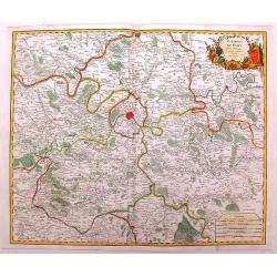
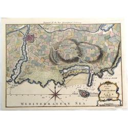
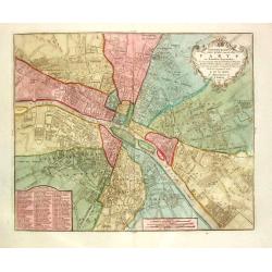
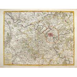
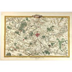
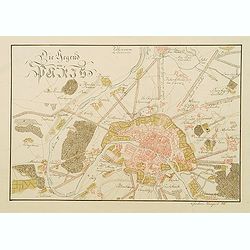
Environs de Paris
Detailed map of Paris and its surroundings with a decorative title cartouche and with cities, towns, forests. lakes, rivers & mountains clearly delineated. Gilles Rob...
Place & Date: Paris, 1753
Selling price: $71
Sold in 2014

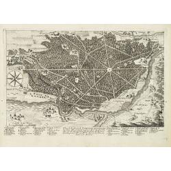
La Citta di Nizza Capitale della Contea di Nizza.
Fine panoramic views of Nice, taken from Storia moderna di tutti I popoli del mondo , edited by Thomas Salmon. A Italian edition of this famous work, published in 26 volu...
Place & Date: Venice, 1740-1756
Selling price: $210
Sold in 2011
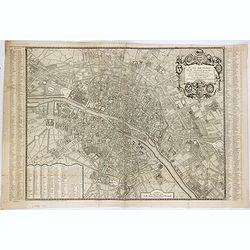
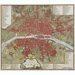
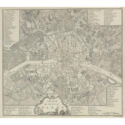
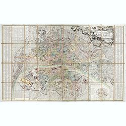
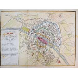
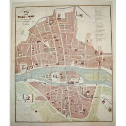
Plan de Paris divisé en seize quartiers. . .
Large decorative plan with lettered key to the streets, parishes, colleges, hospitals and communities. The end of the address has been erased, state not cited by Vallée.
Place & Date: Paris, 1756
Selling price: $625
Sold in 2021
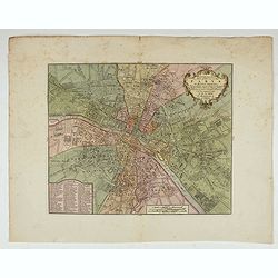
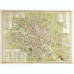
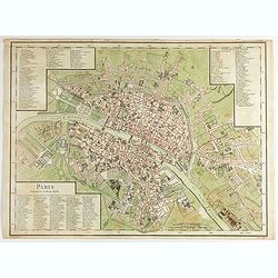
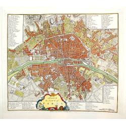
Nieuw kaart der platte Grond van de Stad Parys..
Fine plan of Paris, with detailed keys to the principal buildings of the city. Dated 1756.
Place & Date: Amsterdam, 1756

Paris.
Very rare bird's-eye plan of Paris. To the sides a historical description and a numbered key.George Christophe Kilian (1709-1780) active as engraver of Augsburg published...
Place & Date: Augsburg 1757
Selling price: $150
Sold
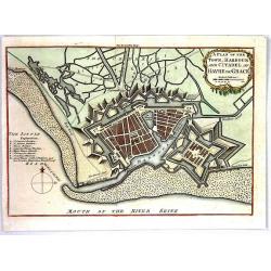
A Plan of the Town, Harbour and citadel of Havre de Grace
A handsome plan of the French port city of Havre de Grace that shows its many fortifications. A key at left locates churches, bastions, etc. Excellent detail of jetties, ...
Place & Date: London, 1759
Selling price: $26
Sold in 2016

Lille.
"A very RARE panoramic view of the city of Lille, including a numbered legend in both lower corners. The plate is numbered in black pencil in upper right corner. Pub...
Place & Date: Paris, 1760
Selling price: $180
Sold

Bourdeaux.
"A very RARE panoramic view of the city of Bordeaux, including a numbered legend in both lower corners. The plate is numbered in black pencil in upper right corner. ...
Place & Date: Paris, 1760
Selling price: $120
Sold

Vüe Méridionale de la Place Royale de Nancy.
So-called optical print illustrating the southern side of the Royal Square in Nancy. Published by Daumont, active at rue St.Martin, who was a well-known publisher of opti...
Place & Date: Paris 1760
Selling price: $185
Sold in 2011

Vue perspective de la Place Royale de Nancy 1760.
So-called optical print illustrating a perspective view of the Royal Square in Nancy.Mondhare, active at rue St.Jacques a l'Hotel Saumur, was a well-known publisher of op...
Place & Date: Paris, 1760
Selling price: $200
Sold in 2011

54e Vue d'Optique Representant Les Cascades de Versailles.
So-called optical print, illustrating a water basin with fountains in the gardens of Versailles.In the eighteenth and nineteenth centuries there were many popular special...
Place & Date: Paris 1760
Selling price: $230
Sold in 2015

Vue du grand Bassin au bas des Tuilleries d'où l'on decouvre la place de Louis XV. Les Champs Elisée tel que cela doit être executé
So-called optical print illustrating a perspective view of the big basin in the Tuileries gardens, in Paris.Mondhare was a well-known publisher of optical prints, establi...
Place & Date: Paris 1760
Selling price: $180
Sold

Vue du Chateau de Maisons du Côté de l'Avenue..
Uncommon, so-called optical print illustrating a perspective view of a castle, probably Fontainebleau.In the eighteenth and nineteenth centuries there were many popular s...
Place & Date: Paris, 1760
Selling price: $200
Sold in 2009

Vüe de la Maison Royalle de choisy du Côté du Jardin
So-called optical print illustrating a perspective view of a royal mansion in Choisy, near Paris.In the eighteenth and nineteenth centuries there were many popular specia...
Place & Date: Paris, 1760
Selling price: $160
Sold in 2010
Plan of the Town and Mole of Agde with the Fort de Brescou.
Fine copper engraved map of Agde near the towns of Marseillan and Bessan, on the coastline of southern France in the Gulf of Lion. By John Hinton engraved for the "N...
Place & Date: London, 1760
Selling price: $50
Sold in 2019

Vue de l'Hôtel de Ville de Marseille du Côté du Port.
Striking copper engraved optical print illustrating a perspective view of the City Hall of Marseille, France, taken from the harbour.In the eighteenth and nineteenth cent...
Place & Date: Paris, 1760
Selling price: $17
Sold in 2018

L'Exterieur de la Chapelle du Chateau de Versailles, du Cote de la Cour.
So-called optical print of The Exterior of the Chapel of the Chateau de Versailles, the Court of Approval (lOUIS XIV'S CHAPEL) by Basset.Basset was a well-known publisher...
Place & Date: Paris , 1760
Selling price: $16
Sold in 2016
A plan of the city of Paris.
Uncommon plan of Paris with a very decorative title cartouche with globe, sun, etc. A numbered key (1-78) to most important buildings and streets in town. Engraved by J. ...
Place & Date: London 1760
Selling price: $170
Sold in 2019

Veuë et Pers-pective de l'Entrée du Château de Marly en général.
A rare panoramic view of the Château de Marly (Marly-le-Roi) by Aveline. The plate, at the joint address of Esnault et Rapilly and Daumont, is numbered in upper right co...
- $250 / ≈ €234
Place & Date: Paris, c. 1760
Plan of the Town and Citadel of St. Martin in the Isle of Re.
This print depicts the town and citadel of St. Martin.
Place & Date: London, 1762
Selling price: $165
Sold in 2017
![Plan de VillaFranche. [22]](/uploads/cache/12242-250x250.jpg)
Plan de VillaFranche. [22]
Charming of Villefranche. Showing town and harbor plan, with soundings, anchorages, rocks, shoals, fortifications, lighthouses.Joseph Roux (1725-1793) was a Marseilles h...
Place & Date: Marseille, 1764
Selling price: $45
Sold

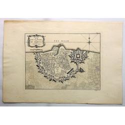
Plan du port ville et chateau de Ville-Franche.
Detailed chart which shows forts and buildings in Villefranche-sur-Mer . Decorative title cartouche. Relief shown pictorially. Depth shown by soundings. Engraved by Grois...
Place & Date: Paris, 1764
Selling price: $50
Sold in 2015
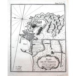
Plan de St. Torpés.
Detailed chart which shows the port, the fort and buildings in Saint-Tropez. Decorative title cartouche. Relief shown pictorially. Published in Bellin's famous "Le P...
Place & Date: Paris, 1764
Selling price: $75
Sold in 2016

Plan de Nice.
Detailed chart of Nice and its surrounding area. Indicated the outline of buildings, streets, and the fortifications. Decorative title cartouche. Published in Bellin's fa...
Place & Date: Paris, 1764
Selling price: $75
Sold in 2016
Nieuwe kaart der platte Grond van de Stad Parys en derzelve voorsteden
Izaak Tirion (d. 1769) Amsterdam publisher. His ' Nieuwe en beknopte handatlas' saw 6 editions between before 1740 and after 1784. Also ' Tegenwoordige staat van alle vol...
Place & Date: Amsterdam, c. 1770
Selling price: $160
Sold

Vue et Perspective de la Superbe Colomnade de Versailles.
Striking optical print featuring the columns and the gardens at Versailles, near Paris. France. In the eighteenth and nineteenth centuries many specialty establishments i...
Place & Date: Paris, 1770
Selling price: $109
Sold in 2016

Vue de la Nouvelle Decoration de la Foire St. Germain.
A hand colored optical print published in Paris by Jacques Chereau in about 1770. During the 18th century there were several manufacturers of optical viewing devices and...
Place & Date: Paris, ca. 1770
Selling price: $17
Sold in 2019
![Illumination en réjouissance du Mariage de Louis Auguste Dauphin de France avec l'Archiduchesse Marie Antoinette sœur de l'Empereur : [16 mai 1770].](/uploads/cache/37420-250x250.jpg)
Illumination en réjouissance du Mariage de Louis Auguste Dauphin de France avec l'Archiduchesse Marie Antoinette sœur de l'Empereur : [16 mai 1770].
J. Chereau was a publisher of optical print, established in Paris, rue St.Jacques. In the eighteenth and nineteenth centuries there were many popular speciality establish...
Place & Date: Paris, ca. 1770
Selling price: $75
Sold in 2017
A Plan of the City of Paris.
Nicely detailed 18th century map of Paris, published in A collection of plans of the most capital cities of every empire, kingdom and electorate in Europe and some remark...
Place & Date: London, 1771
Selling price: $90
Sold in 2009
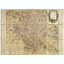
Plan routier de la Ville et Faubourg de Paris.
Grid plan. On both sides of the map, an alphabetical map of the streets Updates: North, opening of Thiroux Street, new name of St. Anne Street, which becomes rue Poissonn...
Place & Date: Paris, 1776
Selling price: $900
Sold
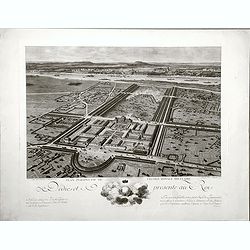
Plan perspective de l'École royale militaire.
A decorative bird's eye view of the complex of the French military school in Paris, 1777, showing all grounds and buildings of the 'Ecole Royale Militaire', drawn 'd'apr�...
- $250 / ≈ €234
Place & Date: Paris, 1778

Hotel des Monnoies, Projete sur le Terrein de l'Hotel de Conty
Very large copper engraving featuring a view of the Hotel de Monnaies, a C-shaped mansion with steps outside the courtyard. The engraver was Claude Rene Gabriel Poulleau ...
Place & Date: Paris, c1780
Selling price: $220
Sold in 2020

Vue Perspective de la Place des Victoires.
Optical print of Place des Victoires in Paris.
Place & Date: Paris, 1780
Selling price: $23
Sold in 2018

Vue General du Chateau de Monseigneur le Duc de Richelieu en Poitou.
Optical print of Place des Victoires in Paris. Basset was a well-known publisher of optical prints, established in rue St Jacques in Paris. In the 18th century the optica...
Place & Date: Paris, 1780
Selling price: $17
Sold in 2018
Carte de la Prevoste et Vicomte de Paris.
The large very detailed map of Paris was originally created by Guilliame Deslise or De L'Isle (1675-1726). Delisle is best known for his changes to cartography that resul...
Place & Date: Paris, 1782
Selling price: $120
Sold in 2013
Paris Superficie 5,280,000 Toises.
FIRST EDITION of this finely engraved plan of Paris by P. F. Tardieu and prepared by DuBuisson. This detailed plan of Paris includes la Place Louis XV, la Bastille, but d...
Place & Date: Paris, 1779-1782
Selling price: $325
Sold in 2020
Paris Superficie 5,280,000 Toises.
FIRST EDITION of this finely engraved plan of Paris by P. F. Tardieu and prepared by DuBuisson. This detailed plan of Paris includes la Place Louis XV, la Bastille, but d...
- $600 / ≈ €561
Place & Date: Paris, 1779-1782
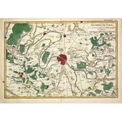
Environs de Paris.
Rigobert Bonne (1727-1795), French cartographer. His maps are found in a.o. Atlas Moderne (1762), Raynal's 'Histoire Philos. du Commerce des Indes' (1774) and 'Atlas Ency...
Place & Date: Paris, 1784
Selling price: $80
Sold
Les Environs de Paris...
A fine hand colored copperplate map of Paris featuring The Versailles Gardens. The map extends along the Seine. It was engraved by Herault in 1787.
Place & Date: Paris, 1787
Selling price: $73
Sold in 2019
Plan de la forest de Compiègne appartenante au Roy. . .
A very decorative and rareof Forest of Compiegne, in the Picardy reggion. Including a numbered key (A-Z and 1-10) in lower part. Engraved by Pierre-Alexandre Aveline. Wit...
Place & Date: Paris, ca.1792
Selling price: $150
Sold in 2013
Nouveau plan routier de la ville et faubourgs de Paris Divisé en 48 sections d'après le Décret de l'Assemblée.
Beautiful plan of Paris in original colors. Second edition dated 1792 of five issues published between 1790 and 1797.Title cartouche decorated with a view of the Seine, a...
Place & Date: Paris, 1792
Selling price: $700
Sold in 2020

Pianta di Forti, e Trincieramenti Della Vitta di Tolone
A bird’s-eye view of the fort Toulon, France with the surrounding area. The map features the siege of Toulon which took place in 1793. After loyalist royalists had take...
Place & Date: Paris, 1793
Selling price: $20
Sold in 2016

Plan Geometral De Paris Et De Ses Fauxbourgs...
This exceptionally large, rare plan de Paris is a revision of De Vaugondy's smaller plan of 1783. This print was published by Delamarche who was the successor of Vaugondy...
Place & Date: Paris, 1797
Selling price: $290
Sold in 2019

Piano di Nizza.
Rare 1797 manuscript map of Nice, with the French navy attacking from the sea. Unknown author, Italian, but map attributed to an original, probably broadsheet map by Moll...
Place & Date: Italy, after 1797
A Plan of the City of Paris.
A handsome and finely engraved plan of Paris based on late 18th century information. The work contains three legends identifying 78 points of interest, including major la...
Place & Date: London, dated 1800
Selling price: $340
Sold
Paris sous le regne de Louis XIII.
Unusual plan which shows Paris as it was in the beginning of the 17th century. A very detailed map, with street names, parks, places, hospitals, and important buildings s...
Place & Date: after 1800
Selling price: $50
Sold in 2016
Plan de la ville de Paris dressé géométriquement d'après celui de la Grive, avec ses changements et augmentations.
Charming book forming a plan of Paris engraved by Perrier Oncle and written by Pelicier. Beautiful copy in very fresh colors.
Place & Date: Paris, 1803
Selling price: $1500
Sold in 2020

Vue du Pont des Arts.
Fine Vue Optique featuring the neighbourhood close to the Louvre. The bridge was the first iton bridge in Paris. Unlike most Vue Optique prints, the hand-coloring on this...
Place & Date: Paris, 1805
Selling price: $27
Sold in 2019

Ceremony of Te Deum by the allied armies..
View of a military ceremony at the square Louis XV in Paris.
Place & Date: London 1815
Selling price: $160
Sold

PLAN DE LA VILLE DE PARIS, DIDIE ET PRESENTE AU ROI
A very large and exceedingly rare copperplate engraved plan of Paris with the River Seine at its center. An incredibly detailed work that identifies all streets, parks, g...
Place & Date: Paris, dated 1816
Selling price: $600
Sold
Die Gegend um Paris.
Very detailed manuscript plan in pen and ink with water color of Paris and it immediate environs. Singed with brown ink: "Christian Laugart (1)816 ".
Place & Date: Paris, 1816
Selling price: $300
Sold in 2008

Departement de Paris en 12 Justices de Paix et 12 Maires.
Detailed map centered on Paris. Taken from "Atlas national de France", the first atlas with the departments of France published by Pierre Grégoire Chanlaire.
Place & Date: Paris, P.G. Chanlaire, 1818
Selling price: $120
Sold

Vue du Palais de la Bourse.
Optical view of the stock exchange in Paris. In the eighteenth and nineteenth centuries there were many popular specialty establishments in Paris, Augsburg and London, wh...
Place & Date: Paris, ca. 1820
Selling price: $26
Sold in 2019

Carte des Environs de Paris.
A large, very detailed map of Paris and her surrounding area by Pichon (Ingeniur Geographe) and corrected by Amedee Martin. It was published by Chez Esnault in Paris in 1...
Place & Date: Paris, 1821
Selling price: $40
Sold in 2019

Plan de la Ville de Lyon, et ses environs, réduit d'apres les meilleurs levés, corrigé, augmenté et gravé d'après des plans particuliers et des reconoissances faites sur les lieux.
With the title at upper right, an alphabetical street index at upper left, an index of other features at lower left and right, and a scale of metres at lower right, the r...
Place & Date: Lyon, chez Midan libraire, 1830
Selling price: $200
Sold
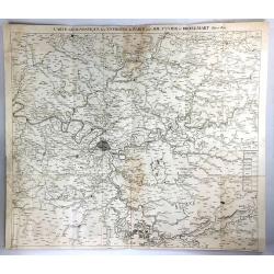
Carte Geognostique des Environs de Paris
A large detailed map from "Memoires de la Classe des Sciences Mathematiques et Physiques de l`Institut Imperial de France", by Cuvier & Brongniart, publishe...
Place & Date: Paris, 1835
Selling price: $21
Sold in 2016
Plan de la Ville de Paris, sous Phillipe de Bel...
An uncommon, large scale, decorative early 19th century plan of Paris. The work was commissioned by architect Albert Lenoir. Important buildings are highlighted and stree...
Place & Date: Paris, 1837
Selling price: $425
Sold

Château de Rustephan. (Bretagne).
A view of the ruin of Rustephan Castle. Made "after nature" by Serda in 1837.
Place & Date: Paris, ca. 1840
Selling price: $20
Sold in 2009

Eglise et cimetière a St. Marc. (Bretagne).
A view of the cemetery of St. Marc in Bretagne. Made "after nature" by Serda in 1837. Lithographed by Vulleneuve.
Place & Date: Paris, ca. 1840
Selling price: $20
Sold in 2009

Vue de Monaco du côté du nord . . .
Extremely rare lithographed view of Monaco seen from the north side, lithographed by Jean Baptiste François Bosio, born June 17, 1764 in Monaco, and died July 6, 1827 in...
Place & Date: Monaco, 1841
Selling price: $1000
Sold
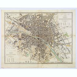
Western & Eastern Division Of Paris.
A detailed map of the French capital. Below it are 21 outlined perspectives of the iconic and important buildings and monuments within the city. Western and Eastern Quart...
Place & Date: London, 1842
Selling price: $65
Sold in 2018
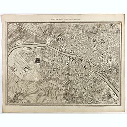
Plan de Paris Par Roussel Caqpt. Ingénieur en 1700.
Plan of the center of Paris by Claude Roussel (1655-172.?). here in a later reprint from around 1844.
Place & Date: Paris, after or ca. 1844
Selling price: $150
Sold
![[Fortifications de Paris.]](/uploads/cache/48146-250x250.jpg)
[Fortifications de Paris.]
A lovely quite detailed plan of Paris published towards the middle of the 19th century. The plan identifies the various fortifications that surrounded the city. They are ...
Place & Date: Paris, ca 1845
Selling price: $100
Sold in 2022

PARIS. Vue prise au dessus du Rond-Point des Champs-Elysées.
From Voyage aerien en France, L'Italie à vol d'oiseau. Made by Jules Arnout and printed by Lemercier. Published by A.Hauser. Bd. des Italiens.The publication is extrem...
Place & Date: Paris, c.1850
Selling price: $400
Sold

Departement de La Seine Environs de Paris.
A decorative 19th century map of the French department de La Seine with its capital Paris. The map is surrounded by two descriptive text panels to the left and right and ...
Place & Date: Paris, ca. 1850
Selling price: $300
Sold
Plan Itinéraire De Paris.
Folding plan of Paris divided into numbered and lettered squares, corresponding indices of streets and public buildings to left and right edges. Original color in block a...
Place & Date: Paris: J. Andriveau-Goujon, 1853
Selling price: $120
Sold in 2012
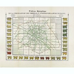
Tableau synoptique de la circulation des omnibus à correspondances de Paris.
Synoptic table of the circulation of omnibuses with connections of Paris indicating at first sight the resources presented by the one hundred and sixty-seven connections ...
- $750 / ≈ €702
Place & Date: Paris, ca. 1854
Plan de Paris - Paris
PRINTED ON VELLUM. Large nine panel plan of Paris, if joined height: 52 inches (1321 mm). width: 58 inches (1473 mm). This is the 1856 edition etched by E.Lebel for "...
Place & Date: Paris, Société des Bibliophiles, 1856
Selling price: $5000
Sold

Dépt. De La Seine. - Paris.
A Decorative map of Paris, including the region of Versailles.Beautiful map from one of the finest decorative atlases of the nineteenth century. This attractive map is fr...
Place & Date: Paris, 1856
Selling price: $40
Sold in 2017

Souvenir de Paris.
Decorative bird's-eye view of the current Louvre Museum, with river Seine and the Notre Dame cathedral on the right. of Paris. After a design by P. St. Martin.
Place & Date: Paris, ca. 1858

Toulouse. Vue du Pont de pierre prise du Quai de Brienne. N°293.
Lithographed view of St. Pierre bridge in Toulouse by C.Mercereau who made the design at the spot and afterwards the lithography.Included in "La France de nos jours&...
Place & Date: Paris, 1860
Selling price: $120
Sold

Paris sous Francois 1er. Vue générale à vol d'oiseau...
Fantastic color lithographed birds-eye view of Paris. Published by Charpentier in "Paris dans sa splendeur".
Place & Date: Paris, ca. 1860
Selling price: $65
Sold in 2016
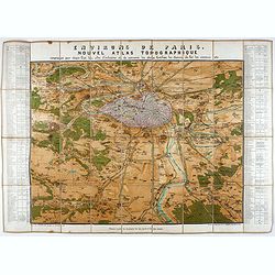
Environs de Paris. Nouvel Atlas Topographique comprenant pour chaque Etat les villes d'industrie et de commerce, les places fortifiées, les chemins de fer, les canaux etc.
A bird's eye-view of Paris and vicinity by Guittet. Centered on Paris and the Seine River and including Versailles, St. Germain, Neuilly, Orly, etc.Paris, in pink, shown ...
Place & Date: Paris, ca. 1862
Selling price: $250
Sold in 2021
Nouveau Plan de Paris divisé en 20 arrondissements.
Detailed plan of Paris and its 20 arrondissements. Also shown are the railway system of the city with its railway stations.From Atlas des Chemins de Fer published by Napo...
Place & Date: Paris 1863
Selling price: $200
Sold in 2010
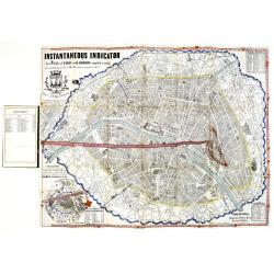
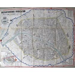
Instantaneous Indicator New Plan of Paris with Ribbon. . .
Instantaneous Indicator New Plan of Paris with Ribbon complete & reetify [sic], for circulating in Paris like the most acquinted [sic] with it, System Acklin, patente...
Place & Date: Paris, Logerot, ca. 1870
Selling price: $400
Sold

La Canonnière la Farcy amarrée en face des Tuileries pendante l'incendie de Paris dans la nuit du 24 Mai 1871.
Very fine lithography in decorative original hand color of the Palais des Tuileries set on fire in the last days of the Paris Commune, either by Communards or by petrol b...
Place & Date: Paris, F. Sinnett, 1871
Selling price: $300
Sold
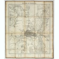
Environs de Strasbourg.
Map of Strasbourg and its direct vincinity, prepared by the Historical Section of the Major General Prussian State, map at 1 / 25,000. Published by E.S. Mittler and Sons,...
Place & Date: Berlin, 1871
Selling price: $950
Sold in 2020
![Portrait de la Ville, Cité et Université de Paris avec les Faubourgs di celle dédié au Roy. [photogravure facsimile from 1880]](/uploads/cache/32083-250x250.jpg)
Portrait de la Ville, Cité et Université de Paris avec les Faubourgs di celle dédié au Roy. [photogravure facsimile from 1880]
This very fine photogravure plate is showing Paris at medieval times after Nicolay. This late 19th century and slightly reduced facsimile of this famous and very rare pla...
Place & Date: Paris, c.1880
Selling price: $1900
Sold
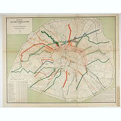
Recettes des lignes d'omnibus de Paris en 1880.
Detailed plan of Paris showing the movements of passengers between the different stations in the year 1880. Legends in the lower right and left corners, including the num...
Place & Date: Paris, Monrocq, 1882