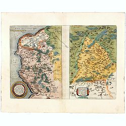
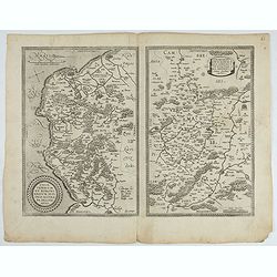
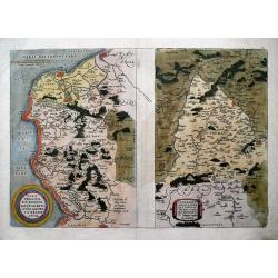
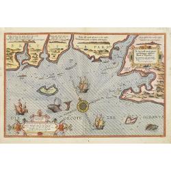
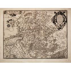
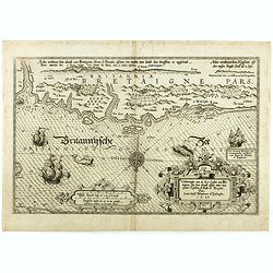
Caletensium et Bononiensium.. / Veromandorum. . .
Two maps on one sheet. Left map, entitled Caletensium, depicts the French and Belgian coastline from Estables to Calais. The right map, entitled Veromandorum, depicts the...
Place & Date: Antwerp, 1580
Selling price: $75
Sold in 2016
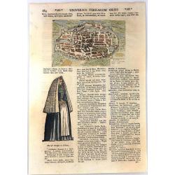
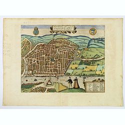
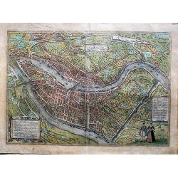
Metz Antiqua et Precipue Belgra Urbs.
A rare early miniature view of Metz by an Italian engraver Francesco Valegio. From the'Nuova raccolta di le piu illustri et famose citta di tutto mondo' by Francesco Vale...
Place & Date: Venice, 1580
Selling price: $95
Sold in 2017
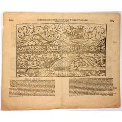
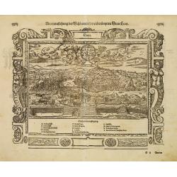
Schletstatt erwan ein Dorff des Heiligen Römischen Reichs.
Woodcut. A topographical map of the imperial city of SELESTAT or Schletstad in the province of Alsace, France. Published by Münster in the German edition of “Cosmogra...
Place & Date: Basel, 1580
Selling price: $19
Sold in 2016
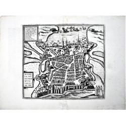
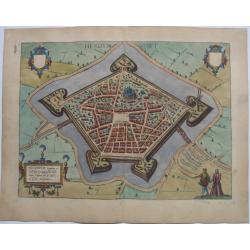
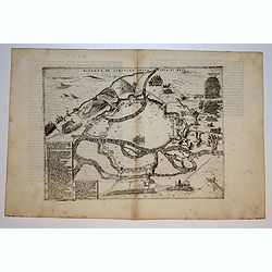
Rochella Munitissimum Galliae Opp.
A fine example of the plan of La Rochelle, with its defensive fortifications. From the greatest publication in this genre!. The plates from Georg Braun and Frans Hogenber...
Place & Date: Cologne, 1580
Selling price: $88
Sold in 2022
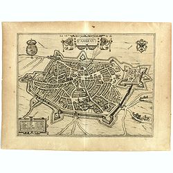
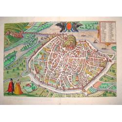
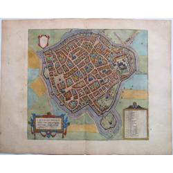
La Ville de Cambray.
Bird's eye view with citadel. - From the greatest publication in this genre!. The Civitates was compiled and written by George Braun, Canon of Cologne Cathedral. Braun ga...
Place & Date: Cologne, 1580
Selling price: $55
Sold in 2020
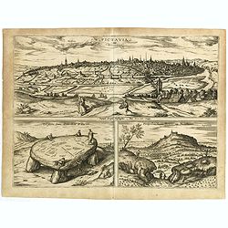
Pictavia vulgo Poictiers / La pierre leuee demie lieue de Poictiers / Prospectus Montis Henrici vulgo Montherri.
Bird's-eye view of Nocera Umbra and Castelnuovo. - From the greatest publication in this genre!. The Civitates was compiled and written by George Braun, Canon of Cologne ...
Place & Date: Cologne, 1580
Selling price: $70
Sold in 2019
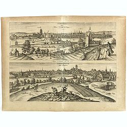
Tvrones vulgo Yours le jardon de France / Andegavvm vulgo Angiers.
Two decorative views on one double page. - From the greatest publication in this genre!. The Civitates was compiled and written by George Braun, Canon of Cologne Cathedra...
Place & Date: Cologne, 1580
Selling price: $200
Sold in 2018
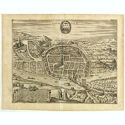
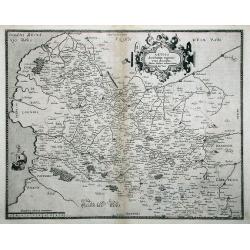
Saintes.
Decorative bird's-eye view on one double page. - From the greatest publication in this genre!. The Civitates was compiled and written by George Braun, Canon of Cologne Ca...
Place & Date: Cologne, 1580
Selling price: $60
Sold in 2020
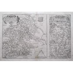
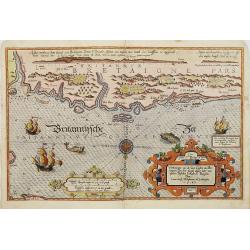
1) Caletensivm et Bononiensivm..2) Veromandvorvm eorvmque..
Prepared by Jean Surhon, cartographer, goldsmith and engraver. From 'Theatrum Orbis Terrarum [Atlas of the Whole World]': published in Antwerp.
- $200 / ≈ €187
Place & Date: Antwerp, 1580
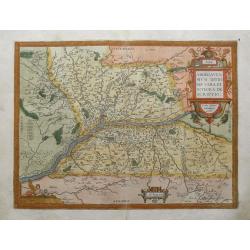
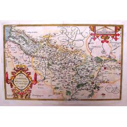
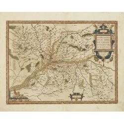
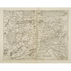
Regionis Biturigum Exactiss: Descriptio per D. Ioannem Calamaeum / Limaniae Topographia Gabriele Symeoneo Auct.
A pair of fine maps on a full folio sheet. The map of Biturigum is centered on Chateau Neuf and Bourges, with the Loire River flowing at the top right of the map to Never...
Place & Date: Antwerp, 1581
Selling price: $45
Sold in 2016
![Grenoble & Romans-sur-Isère. - Gratianopolis Acusianoru Colonia, ... [on sheet with] Romans Delfinatus vulgo Daufine in Gallia Oppidu.](/uploads/cache/85902-250x250.jpg)
Grenoble & Romans-sur-Isère. - Gratianopolis Acusianoru Colonia, ... [on sheet with] Romans Delfinatus vulgo Daufine in Gallia Oppidu.
Fine antique copper engraved sheet with two bird's-eye views/plans by Braun and Hogenberg: Grenoble & Romans-sur-Isère from the third volume of Braun & Hogenberg...
Place & Date: Cologne, 1581
Selling price: $230
Sold in 2021
![Autun & Nevers. - Augustodunum [on sheet with] Noviodunum.](/uploads/cache/85903-250x250.jpg)
Autun & Nevers. - Augustodunum [on sheet with] Noviodunum.
Fine antique copper engraved sheet with two bird's-eye plans on one sheet: Autun and Nevers, from the third volume of Braun & Hogenberg's "Civitas Orbis Terrarum...
Place & Date: Cologne, 1581
![Chartres & Châteaudun. - Autricum, Prolemeo in Gallia Lugdunensis Urbs; vulgo, cum Villa nouano, Chartres. [on sheet with:] Chasteaudunum, Comitatus vulgo Dunoys in Gallia Oppidum primorium.](/uploads/cache/85904-250x250.jpg)
Chartres & Châteaudun. - Autricum, Prolemeo in Gallia Lugdunensis Urbs; vulgo, cum Villa nouano, Chartres. [on sheet with:] Chasteaudunum, Comitatus vulgo Dunoys in Gallia Oppidum primorium.
Fine antique copper engraved sheet with two bird's-eye plans by Braun and Hogenberg: Chartres and Châteaudun. From the third volume of Braun & Hogenberg's "Civi...
Place & Date: Cologne, 1581

Lille - Insula - Ryssele.
A fine antique bird's-eye plan of Lille with key to locations, by Braun and Hogenberg, from the: Civitates Orbis Terrarum, ... Part 3. Köln, 1581. COMMENTARY BY BRAUN: ...
Place & Date: Cologne, 1581

Valenciennes, Valencena, quondam Cygnorum Vallis, Urbs Han: Perelegas, et Valde Magnifica.
A fine antique bird's-eye plan of Valenciennes, by Braun and Hogenberg, from the: Civitates Orbis Terrarum, ... Part 3. Köln, 1581. TRANSLATION OF CARTOUCHE TEXT: Valen...
Place & Date: Cologne, 1581

Arras - Atrebatum, fertilissimae Artesiae Urbs primaria, elegantissimo situ, . . .
A fine antique bird's-eye plan of Arras with key to locations, by Braun and Hogenberg, from the: Civitates Orbis Terrarum, ... Part 3. Köln, 1581. TRANSLATION OF CARTOU...
Place & Date: Cologne, 1581

Douai, - Duacum, Catuacorum Urbs, tam situ, quam incolis, et litterarum studijs elegantissime ornata.
A fine antique map - bird's-eye view of Douai, by Braun and Hogenberg, from the: Civitates Orbis Terrarum, ... Part 3. Köln, 1581. TRANSLATION OF CARTOUCHE TEXT: ...
Place & Date: Cologne, 1581
Selling price: $200
Sold in 2022

Rouen, - Rhotomagus, Galliae Lugdunensis as Sequanam flu. Opp. vulgo Rouen.
A fine antique map - bird's-eye view of Rouen, by Braun and Hogenberg, from the: Civitates Orbis Terrarum, ... Part 3. Köln, 1581.With a French key to locations. Two ...
Place & Date: Cologne, 1581
Selling price: $290
Sold in 2022
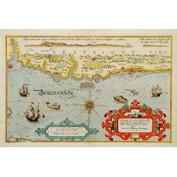
Verthoninghe van de Zee Custen van Bretaignen..
A very decorative chart covering the coast along the coast of Britany. South to the top. A first edition, without the previlegio. Engraved by the master engraver, Johanne...
Place & Date: Amsterdam 1584
Selling price: $1700
Sold
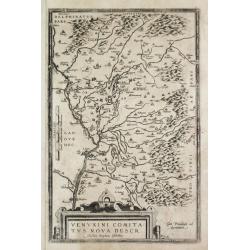
Venuxini Comitatus Nova Descr. Auctore Stephano Ghebellino.
Abraham Ortelius(1527-98), Dutch cartographer and publisher of the first modern atlas, ' Theatrum Orbis Terrarum' in 1570. Editions till 1612. Also an atlas of ancient ca...
Place & Date: Antwerp, 1584
Selling price: $150
Sold
Caletensium Et Bononiensium Ditionis Accurata Delineatio & Veromanduorum Eorum Que Confinium Exactissima Descriptio...
Two detailed regional maps by Ortelius. The first map shows Belgian and French Coastal region, from Etaples to Gravelines, with Calais, Boulogne-sur-Mer. The second map s...
Place & Date: Antwerp, 1584
Selling price: $102
Sold in 2013
Anjou / Andegavensium Ditionis Vera et Integra Desciptio.
Very decorative map of a region in France, centered on the Loire River and Angiers. Highly detailed with hundreds of villages shown, forests, hills, etc. Includes several...
Place & Date: Antwerp, 1584
Selling price: $45
Sold in 2015
Avignon.
A fine bird?s eye view of the ancient capital of Provence, Avignon, from the famous CIVITATES ORBIS TERRARUM. The work contains a 45 point legend, identifying key sights....
Place & Date: Cologne, 1585
Selling price: $475
Sold
Chartae orarum . . . . Caerte vanden zee Custen, eensdeels Normandien, en Brittangen. . .
A detailed chart of the Normandy coast and the channel islands of Jersey, Guernsey, Alderney and Sarck decorated by a colorful title cartouche and scale cartouche, two co...
Place & Date: Leiden, Plantijn, 1585
Selling price: $3400
Sold in 2008
De zee Custe, met de England van Bretaignen, tusschenn Blauet en Picqueliers. . .
DUTCH TEXT EDITION. A detailed chart of the coast of southern part of Brittany, covering the coast from Vannes till Hilaire-de-Riez. Decorated by a colorful title cartouc...
Place & Date: Leiden, Plantijn, 1585
Selling price: $3000
Sold in 2009
Verthoninghe van zee Cuften van Bretaignen. . .
DUTCH TEXT EDITION. A detailed chart of the coast of Brittany decorated by a very colorful title cartouche and scale cartouche, one compass rose, several vessels and sea ...
Place & Date: Leiden, Plantijn, 1585
Selling price: $3000
Sold
Picardiae Belgicae Regio Nis Descriptio
A highly detailed copper engraved map of the Picardie region in Northwest France by Abraham Ortelius. This map is finely engraved with forests, cities, villages along the...
Place & Date: Antwerp, ca. 1585
Selling price: $69
Sold in 2015
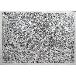
ARTESIA Comit.
Mercator's early map of the northern French region of Artois. Divisions in outline colors, strap-work title cartouche and mileage scale in the upper right, and lower left...
Place & Date: Duisbourg, 1585
Selling price: $12
Sold in 2021

Beschrijvinge vande de zee Cuften va Vlanderen en Picardien. . .
A detailed description of the coast of Picardie and Normandy decorated by a large colored baroque title cartouche, and the coat of arms of Flanders with a colorful scale ...
- $1750 / ≈ €1638
Place & Date: Amsterdam, 1585
Nobilis Hannoniae Comitatus Descrip. 1579.
Abraham Ortelius(1527-98), Dutch cartographer and publisher of the first modern atlas, ' Theatrum Orbis Terrarum' in 1570. Editions till 1612. Also an atlas of ancient ca...
Place & Date: Antwerp, 1588
Selling price: $80
Sold in 2018
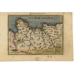
Normandia.
Miniature map of the coast of France at Normandy. Latin text on verso.
Place & Date: Antwerp, 1588
Selling price: $100
Sold
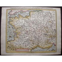
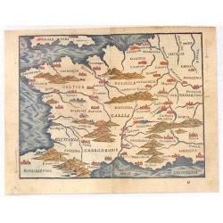
Das gantz Franckreich, so vorzeiten Narbonensis, Lugdunensis, Belgica und Celtica, ist genennt worden.
This nicely colored, charming early woodcut map of France was published in the 1588-edition of Sebastian Münster’s Cosmographia. Mountains, villages, churches and wood...
Place & Date: Basle, S.H. Petrie, 1588
Selling price: $120
Sold in 2014
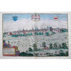
Bethunae urbis Artesiae Genvina Descrip.
An uncommon view of Bethune, located in Pas-de-Calais. Shows the city behinds its walls, with numerous detailed buildings, some named above.The view provides a fine depic...
Place & Date: Cologne, 1588
Selling price: $175
Sold in 2016
![Mâcon & Chalon-sur-Saône. - Matiscona, vulgo Mascon; ad Araeim flu: probe munitum Burgundiae Oppidum M.D.LXXX [on sheet with] Cabillinum, Indigenis, Chalon, ut agri uberiimi, ita saluberrimi coeli, . . .](/uploads/cache/85899-250x250.jpg)
Mâcon & Chalon-sur-Saône. - Matiscona, vulgo Mascon; ad Araeim flu: probe munitum Burgundiae Oppidum M.D.LXXX [on sheet with] Cabillinum, Indigenis, Chalon, ut agri uberiimi, ita saluberrimi coeli, . . .
Fine antique copper engraved sheet with two bird's-eye views by Braun and Hogenberg: Mâcon and Chalon-sur-Saône. from the forth volume of Braun & Hogenberg's &quo...
Place & Date: Cologne, 1588
St. Omer. - S. Audomari Fanum S. Aulmer, ...
A handsome birds-eye view/map of the northwest French city of St. Omer, from "Civitates Orbis Terrarum", in fine color. From the uncommon forth volume of Brau...
Place & Date: Cologne, 1588
Hesdin, - Hesdyn Fort
A fine antique map - bird's-eye view of Hesdin, by Braun and Hogenberg, from the: Civitates Orbis Terrarum, ... Part 4. Köln, 1588. This striking bird's-eye plan ...
Place & Date: Cologne, 1588

Bethune.
A fine antique panoramic view of Bethune, by Braun and Hogenberg, from the: Civitates Orbis Terrarum, ... Part 4. Köln, 1588. TRANSLATION OF CARTOUCHE TEXT: True-to-lif...
Place & Date: Cologne, 1588

Cambrai - Cambray.
A fine antique panoramic view of Cambrai, by Braun and Hogenberg, from the: Civitates Orbis Terrarum, ... Part 4. Köln, 1588.COMMENTARY BY BRAUN: "Cambrai is a bro...
Place & Date: Cologne, 1588
Abcontrafehtung der schönen und weitberümpten Statt Leon.
Map shows the city of Lyon wit a beautiful border.From a German text edition of his Cosmographia , that great compendium of Renaissance knowledge.
Place & Date: Basle 1550-1590
Selling price: $90
Sold
Andegavensium Ditionis Vera et Intregra Descriptio.
Decorative map centered on the Loire River and Angiers. Includes several bridges across the Loire and its tributaries.Prepared by Licimo Guyeto Andegauense.
Place & Date: Antwerp, 1590
Selling price: $220
Sold in 2013
Andegavensium Ditionis Vera et Intregra Descriptio.
Early map of the Loire Valley, with Angiers in the center. Prepared by Lézin Guyet in 1579.
Place & Date: Antwerp, 1590
Selling price: $55
Sold in 2010
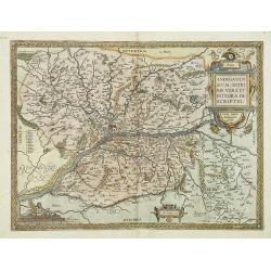
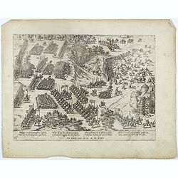
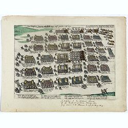
Hie siechstu wie gelegen seint . . Plate 261.
Early print showing an army position near the town of Dreux in France on 14 March 1590 during the French Wars of Religion.Plate from the series about the " Eighty Ye...
Place & Date: Cologne, ca. 1590
Selling price: $25
Sold in 2020
Des Konigs undder Fursten regiment . . . Plate 32.
Plate from the series about the " Eighty Years' War" or the independence war of Holland against Spain, we know of approximately four hundred engravings by Frans...
Place & Date: Cologne, ca. 1590
Selling price: $25
Sold in 2020
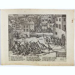
PARIS
Early print showing the capture of Barnabé Brisson in Paris, who was hanged on 15 November by the Spanish.Plate from the series about the " Eighty-Years War" o...
Place & Date: Cologne, ca. 1590
Selling price: $75
Sold in 2020
![[Matiscona / Chalon-sur-Soane].](/uploads/cache/43146-250x250.jpg)
[Matiscona / Chalon-sur-Soane].
MACON: This is a bird's-eye view from the south of the town, which is fortified with moats, walls and bastions. With numerous churches, including the Gothic cathedral of ...
Place & Date: Cologne, ca 1590
Selling price: $70
Sold in 2019
![[Hesdin]. Hesdinum. . .](/uploads/cache/43147-250x250.jpg)
[Hesdin]. Hesdinum. . .
A perspective birds-eye view of the northern French city of Hesdin. It lies in the 'Pay-de-Calais region. The city is dominated by a large town square and the church of N...
Place & Date: Cologne, ca 1590
Selling price: $50
Sold in 2019
RHOTOMAGUS Galliae... Rouen.
A lovely bird's-eye plan of Rouen by Braun and Hogenberg, with a French key to locations. Two costume figures at bottom. This bird's-eye view from the north conveys a cle...
Place & Date: Cologne, ca 1590
Selling price: $130
Sold in 2019
![[St. Omer]. S. Audomari Fanum A. Aulmer. Omer Iccius portus Abrahamo Orttelio, artesij urbs munitissima.](/uploads/cache/43145-250x250.jpg)
[St. Omer]. S. Audomari Fanum A. Aulmer. Omer Iccius portus Abrahamo Orttelio, artesij urbs munitissima.
This is a bird's-eye view from the south of the town, which is fortified with moats, walls and bastions. Numerous churches stand out, including the Gothic cathedral of No...
Place & Date: Cologne, ca 1590
Selling price: $50
Sold in 2020
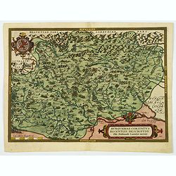
Burgundiae Comitatus Recentiss. Descriptio.
A decorative and attractive regional map of Burgundy in France, that is centered on Besancon, Poligny, Quingey and St Anne. It includes a number of famous wine regions, f...
Place & Date: Antwerp, ca 1590
Selling price: $80
Sold in 2020
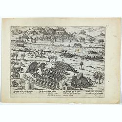
Philippus Scrossy Italianisscher Capitein uber des Bapstes kriegsher zogh hinein. . . Plate 65.
Early print showing the battle between Captain Stossi and the Hugonots at la Roche-l'Abeille on 5 June 1569.Plate from the series about the " Eighty Years War" ...
Place & Date: Cologne, ca. 1590
Selling price: $50
Sold in 2023
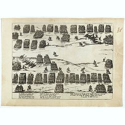
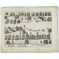
(Possitions of a battle at Ivry (Dreux), 1590 )
Early print showing the positions of a battle at Ivry (Dreux), 1590..Plate from the series about the " Eighty Years War" or the independence war of Holland agai...
Place & Date: Cologne, ca. 1590
Selling price: $25
Sold in 2022
Der Teutschen fursten neu Wer zug auff gericht an 1591.
Early print showing the troops of German princes en route to France, 1591.Plate from the series about the " Eighty Years War" or the independence war of Holland...
Place & Date: Cologne, ca. 1590
Selling price: $25
Sold in 2022
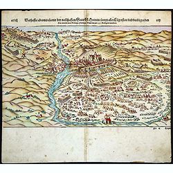
Warhaffte abcontrafactur der namhafften Statt St. Quintin sampt aller Laegerstatt und umbligenden Ort wie sie von Konigs Philippi Heer im jar 1557 belagert worden.
On recto a wood block printed view of the town of St. Quintin besieged by the army of Spanish King Philip II in 1557. From a German text edition of his Geographia , that ...
Place & Date: Basle, 1592
Selling price: $70
Sold in 2018
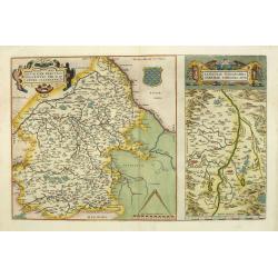
Nova et integra caenomaniae descriptio vulg. Le Mans.
Rare map centered on Le Mans.
Place & Date: Antwerp, 1593
Selling price: $130
Sold
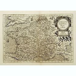
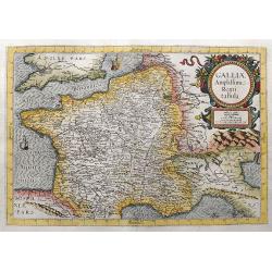
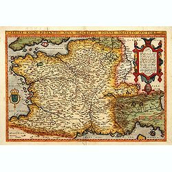
Galliae Amplissimi regni tabula..
Rare map of France.
Place & Date: Antwerp, 1593
Selling price: $715
Sold
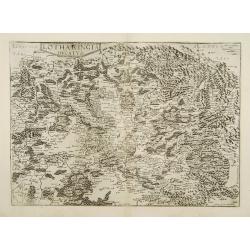
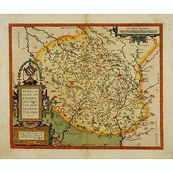
Lotharingia ducatus.
Very rare and beautifully engraved map from De Jode's atlas Speculum Orbis Terrarum . Detailed map of Lorraine.Engraved by Joan and Lucas van Doetecom.RARE.
Place & Date: Antwerp 1593
Selling price: $180
Sold
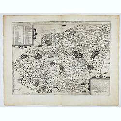
Typus Corographicus Veromanduae.. / Sabaudiae ducatus..
Very rare and beautifully engraved map from De Jode's atlas Speculum Orbis Terrarum . Detailed map of regions along the river Saône River, including Lyon.Engraved by Joa...
Place & Date: Antwerp 1593
Selling price: $270
Sold
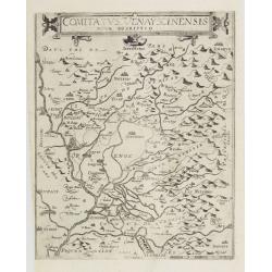
Comitatus Venayscinensis Nova Discriptio.
Rare map depicting part of Provence with Avignon, Cavaillon, Orange, Carpentras, etc.Gerard De Jode was the great rival of Ortelius, both made a living out of selling map...
Place & Date: Antwerp, 1593
Selling price: $280
Sold in 2008
ARTOIS Atrebatum regionis vera descriptio.
De Jode's superb map of Artesia/Flanders. Includes the cities of Calais, Lille, Lens, Arras, Douai, Boulogne-sur-mer,... The map is based on the manuscript map Jacques Su...
Place & Date: Antwerp, 1593
Selling price: $300
Sold in 2011
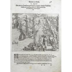
Wie wir zu Honfleur zu Schiff giengen... (Honfleur, Normandy)
The view depicts numerous ships at harbour in Honfleur for loading proviant for their journey to the Americas. From the 3rd book, part 1 of Le Moyne's highly important ac...
Place & Date: Frankfurt, 1593
Selling price: $105
Sold in 2016
Lugdunum (Lyon).
A nice, old-colored view of the French city of Lyon, from the first volume of the famous Civitates Orbis Terrarum. A very decorative, large early map of Lyon, that descri...
Place & Date: Antwerp, 1593
Selling price: $260
Sold in 2018
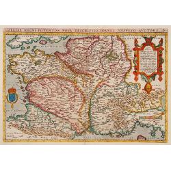
Galliae Amplissimi Regni tabula.
Very rare map which was only published once in the 1593 edition of the Speculum orbis terrae. A highly decorative and beautifully engraved map. Centered on France, also ...
Place & Date: Antwerp, 1593
Selling price: $700
Sold in 2021
Nova et integra caenomaniae descriptio vulg. Le Mans.
Fine separately issued example of Gerard De Jode's map of Caenomaniae (Maine Province), from his Speculum Orbis Terrarum. Gérard de Jode (1508? -1590) published in Antwe...
Place & Date: Antwerp, ca. 1593
Artois. Atrebatum Regionis Vera Descriptio.
Map of Artois, a former province at the northwest tip of France, by Abraham Ortelius. Accompanying Latin text with hand-colored rubric letters on verso. Vibrant, original...
Place & Date: Antwerp, c.1595
Selling price: $120
Sold in 2010
Gallia.
Rather crude but quite charming little woodcut map of Gallia with Celtica, Aquitania, Angliar Pars, Narbonensis, Hispaniae Pars etc., based on Ortelius. Published in 1595...
Place & Date: Venice, 1595
Selling price: $169
Sold in 2016
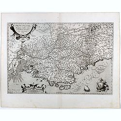
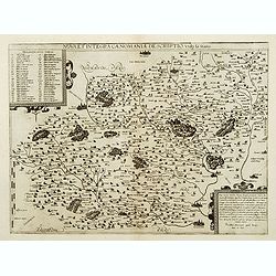
Provinciae, Regionis Galliae, vera exactissimaq. Descriptio..
Early imprint of this decorative map of the Province prepared by Pierre-Jean de Bompar who published a single sheet map of the Province in 1591.Title cartouche on the upp...
Place & Date: Antwerp, 1595
Selling price: $110
Sold in 2016
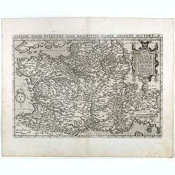
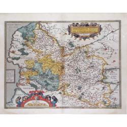
Galliae Regni Potentiss: Nova Descriptio Ioanne Ioliveto Auctore.
A decorative view of 16th Century France that is derived from Jean Jolivet's woodcut map of 1560. Decorated with one large cartouche and one smaller royal crest. The map ...
Place & Date: Antwerp, 1595
Selling price: $70
Sold in 2016
Verthoninghe van de Zee Custen van Bretaignen.
A very decorative chart covering the coast along the coast of Britany. South to the top. A first edition, without the privilege. Engraved by the master engraver, Johannes...
Place & Date: Amsterdam, 1596
Selling price: $1000
Sold in 2018
METZ.
Rare Lafreri School of the siege of Metz by imperial troops of Charles V in 1552-1553, engraved by Paolo Forlani, of the Lafreri school of mapmakers, first published in &...
Place & Date: Venice, 1596
Selling price: $35
Sold in 2018
Artesia cuius incolae Atrebates. . .
A scarce copper engraved map of the Arras region of France by Matthias Quad, a German cartographer based in Cologne. Engraved by Johannes Bussemacher. The map shows the a...
Place & Date: Cologne, ca 1596
Selling price: $27
Sold in 2018
CAMBRAI. - La Ville de Cambray.
A handsome birds-eye view/map of the northeast French city of Cambrai, from "Civitates Orbis Terrarum", in fine color. With a strong graphic element of the ...
Place & Date: Cologne, 1596
Selling price: $220
Sold in 2021

Calais, - Caletum, sive Calesium, vulgo Cales, ..
A fine antique map - bird's-eye view of Calais, by Braun and Hogenberg, from the: Civitates Orbis Terrarum, ... Part 5. Köln, 1596/7.Uncommon, from the 5th Volume ! T...
Place & Date: Cologne, 1597
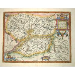
Burgundiae inferioris quae Ducatus Nomine Censetur, Des.
Centered on the province of Burgundy, from his 'Theatrum Orbis Terrarum'.
Place & Date: Antwerp 1598
Selling price: $335
Sold
Galliae Regni Potentiss: Nova Descriptio Ioanne Ioliveto Auc
A decorative view of 16th Century France that is derived from Jean Jolivet's woodcut map of 1560. Decorated with one large cartouche and one smaller royal crest. The map ...
Place & Date: Anvers, 1598
Selling price: $385
Sold
Galliae Regni Potentiss: Nova Descriptio Ioanne Ioliveto Auctore.
A decorative view of 16th Century France that is derived from Jean Jolivet's woodcut map of 1560. Decorated with one large cartouche and one smaller royal crest. The map ...
Place & Date: Antwerp, 1598
Selling price: $360
Sold
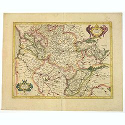
Regionis Biturigum... Per Ioannem Calamaeum. / Limaniae Topographia Gabriele Symeoneo Auct.
Two maps on one sheet.
Place & Date: Antwerp 1598
Selling price: $180
Sold in 2009
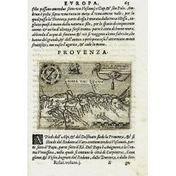
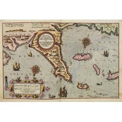
PROVENZA. GALLI NARBONESIS ORA MARITIMA RECETI
Rare copper-engraved miniature map by Giovanni Botero. Shows the Provence with North orientated to the bottom. Charming map with many place names. Decorated with a smal...
Place & Date: Venice, 1598
Selling price: $131
Sold in 2011
Andegavensium Ditionis Vera et Integra Descriptio.
A superbly engraved map of the area around Angers on the Loire exhibiting all the qualities for which Ortelius maps are renowened more that four hundred years after their...
Place & Date: Antwerp, 1598
Selling price: $280
Sold in 2013
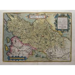
Poictou / Pictonum Vicinarum Que Regionum Fidiss Descriptio...
Beautiful old colored map of the Poitou in Western France by Abraham Ortelius. Showing the Atlantic coast with La Rochelle up to Limoges in the East. Includes the Loire r...
Place & Date: Antwerp, 1598
Selling price: $120
Sold in 2015
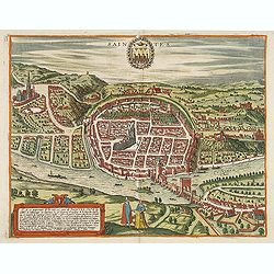
Saintes.
Bid's-eye view of Saintes with the river la Charente in the front. French text on verso.
Place & Date: Cologne, 1598
Selling price: $400
Sold in 2014