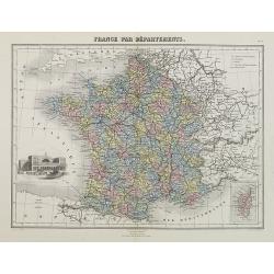
France par Départements.
Decorative map of France from Géographie Universelle, Atlas Migeon. published by J. Migeon. In lower left hand corner a view of a building in Strasbourg engraved by Schr...
Place & Date: Paris 1874
Selling price: $5
Sold
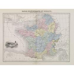
Gaule Indépendante et Romaine.
A decorative map of Ancient France from Géographie Universelle, Atlas Migeon. With an engraving of a Dolmen menhir lower left corner and an inset map of Lutecia (Paris) ...
Place & Date: Paris, 1874
Selling price: $20
Sold
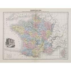
France en 1789 donnant la comparaison immédiate des anciennes Provinces et des Départements actuels.
A thematic showing France in 1789 with its "departments" from Géographie Universelle, Atlas Migeon. With an engraving of the Bastille fortress in 1789 in the l...
Place & Date: Paris, 1874
Selling price: $30
Sold in 2010
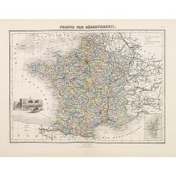
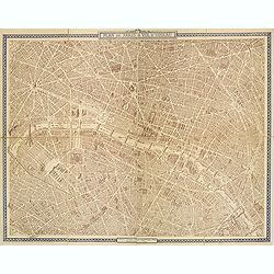
France par Départements.
A decorative map of France divided in its departments from Géographie Universelle, Atlas Migeon. With an engraving of Strasbourg's Rail Road Station in the lower left co...
Place & Date: Paris, 1874
Selling price: $30
Sold in 2017
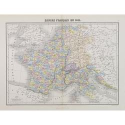
Empire Français en 1811.
A decorative map of the French Empire in 1811 from Géographie Universelle, Atlas Migeon. published by J. Migeon.From one of the last decorative atlases published in the ...
Place & Date: Paris, 1874
Selling price: $20
Sold
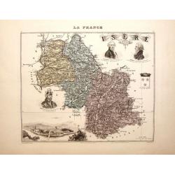
La France - Isere.
Nice decorated hand colored map of the Isere department of France. There are five cartouches including portraits of Vaucanson, Barnave & Bayart, the city of Grenoble ...
Place & Date: Paris, 1878
Selling price: $33
Sold in 2014
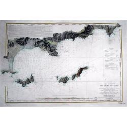
Carte particulière des cotes de France Dept. du Var...
Very large sea chart of a part of the Provence - Côte d'Azur region. From Hyères to Cap Camarat. Includes Ile de Porquerolles, Port-Cros, Ile du Levant. Dated 1843 but ...
Place & Date: Paris, 1879
Selling price: $81
Sold in 2016
![Portrait de la Ville, Cité et Université de Paris avec les Faubourgs di celle dédié au Roy. [photogravure facsimile from 1880]](/uploads/cache/32083-250x250.jpg)
Portrait de la Ville, Cité et Université de Paris avec les Faubourgs di celle dédié au Roy. [photogravure facsimile from 1880]
This very fine photogravure plate is showing Paris at medieval times after Nicolay. This late 19th century and slightly reduced facsimile of this famous and very rare pla...
Place & Date: Paris, c.1880
Selling price: $1900
Sold
Recettes des lignes d'omnibus de Paris en 1880.
Detailed plan of Paris showing the movements of passengers between the different stations in the year 1880. Legends in the lower right and left corners, including the num...
Place & Date: Paris, Monrocq, 1882
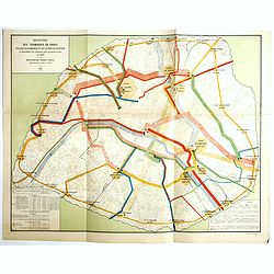
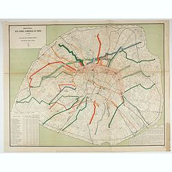
Recettes des tramways de Paris des bateaux-omnibus et du chemin de ceinture et mouvements des voyageurs dans les gares de paris en 1880.
Detailed plan of Paris showing the movements of passengers between the different stations in the year 1880. Legends in the lower right and left corners, including the num...
Place & Date: Paris, Monrocq, 1888
Selling price: $450
Sold in 2018
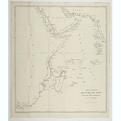
Carte Générale de la Mer des Indes du Cap Bonne Espérance au Cap Comorin.
Map of a part of the Indian Ocean, from Cape of Good Hope to Comorin Cape. Printed by Imp. Dufrénoy, in Paris.
Place & Date: Paris, 1888
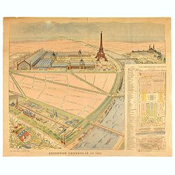
Exposition universelle de 1889.
Very rare broad sheet plan made for The Exposition Universelle of 1889, which was a world's fair held in Paris, from 6 May to 31 October 1889.A bird's eye view of the fai...
Place & Date: Paris, Maison Quantin, 1889
Selling price: $180
Sold
Carte routière de France de Dion Bouton spéciale pour automobiles.
Highly decorative folding wall map of France in a scale of 1 : 800 000. In the upper left hand corner an inset plan of Paris, upper right Algeria and lower right map of C...
Place & Date: Paris, J. Barreau, no date, circa 1900
Selling price: $250
Sold in 2014
![[Les anciennes provinces Françaises à la ville de Saint Denis].](/uploads/cache/41682-250x250.jpg)
[Les anciennes provinces Françaises à la ville de Saint Denis].
Nine small chromolithography's trade cards for Ville de Saint Denis, each with French regions and places, with description in French on each verso.Cards of the regions : ...
Place & Date: Paris, circa 1900
Selling price: $55
Sold in 2018

Eventail cycliste. Boulogne, Paris et ses environs.
Fan, double leaf decorated with a framed map of Bois de Boulogne and two views of Paris. The verso with two plans, one of Paris, the other from the Paris region. Wooden f...
Place & Date: Paris, 1905
Selling price: $200
Sold in 2021
Plan commode deParis rues & monuments autobus & tramways - Guide indicateur des rues de Paris avec les stations du Métropolitain le plus proches. . .
A well-preserved copy of this charming folding map of Paris, in its original hardcover gilted red wrapper. This tourist map starts with a 162pp of index to the streets an...
Place & Date: Paris, ca. 1925
Selling price: $180
Sold
The Picture Map of France.
A large, colorful picture map of France, published by Bowker Co. in New York in 1929. The map was designed and drawn by Harold Haven Brown.This lovely map shows historica...
Place & Date: New York, 1929
Selling price: $50
Sold in 2018
Mer Méditerranée - Côte de France - Golfe de la Napoule Rade de Cannes. . .
Large centered on the Gulf of La Napoule with the harbour of Cannes, the islands Sainte Marguerite and Saint Honorat on the right side. Showing towns, buildings, banks, ...
Place & Date: Paris, 1903 updated 1931
Selling price: $600
Sold
LA CÔTE D'AZUR.
Cover of an illustrated flyer. Printed by E.Imbert & Cie, Grasse -
Place & Date: Grasse, ca. 1935
Selling price: $325
Sold in 2020
Plan de Paris à vol d'oiseau.
A very detailed plan of Paris for the year 1920. Design by Georges Peltier and published by Blondel la Rougery. Lower left "Ce plan dressé d'après nature est la pr...
Place & Date: Paris, Monroco, 1920-1940
Selling price: $180
Sold in 2013

Plan de métro de Paris par Girard et Barrère. Edition de 1942
Miniature metro map of Paris, published by Girard et Barrère, Géographes - Editeurs, 17 rue de Buei, Paris.
Place & Date: Paris, 1942
Selling price: $10
Sold in 2020
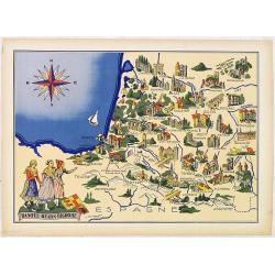
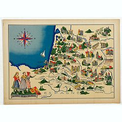
Basque - Bearn - Bigorre.
Very decorative, informative map of Basque - Bearn - Bigorre in south western France. Including the towns of Biarritz, Dax, Bayonne, Lourdes, etc. The map is filled with ...
Place & Date: France, 1943
Selling price: $90
Sold in 2013
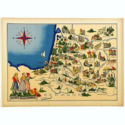
Basque - Bearn - Bigorre.
Very decorative, informative map of Basque - Bearn - Bigorre in south western France. Including the towns of Biarritz, Dax, Bayonne, Lourdes, etc. The map is filled with ...
Place & Date: France, 1943
Selling price: $65
Sold in 2014
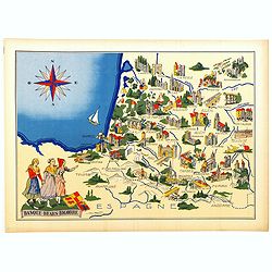
Basque - Bearn - Bigorre.
Very decorative, informative map of Basque - Bearn - Bigorre in south western France. Including the towns of Biarritz, Dax, Bayonne, Lourdes, etc. The map is filled with ...
Place & Date: France, 1943
Selling price: $60
Sold in 2016
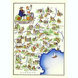
Languedoc - Foix Roussillon.
Very decorative, informative map of Languedoc - Foix Roussillon region in south eastern France. Including the towns of Carcassonne, Montpellier,, Albi, Toulouse, etc.The ...
Place & Date: France, 1943
Selling price: $95
Sold in 2016
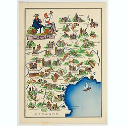
Languedoc - Foix Roussillon.
This is a very decorative, informative map of the Languedoc - Foix Roussillon region in southeastern France, including the towns of Carcassonne, Montpellier,, Albi, Toulo...
Place & Date: France, 1943
Selling price: $40
Sold in 2023
Languedoc - Foix Roussillon.
Very decorative, informative map of Languedoc - Foix Roussillon region in south eastern France. Including the towns of Carcassonne, Montpellier,, Albi, Toulouse, etc.The ...
Place & Date: France, 1943
Selling price: $40
Sold in 2022
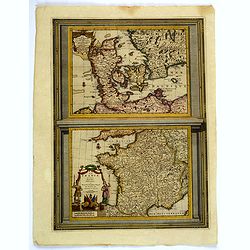
Le Danemarc. . . / La France. . .
A very nice pair of European maps, one the single plate by Pierre Van der Aa. Top map is that of Denmark, with grid lines, compass rose, mileage scales and a decorative t...
Place & Date: Leiden, 1713-29
Selling price: $60
Sold in 2019
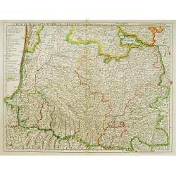
Carte du Bearn de la Bigorre de l'Armagnac..
Map of south-west part of France covering the Landes country with Dax, Bayonne and Pau till Montauban and Toulouse on the right.
Place & Date: Paris [c. 1780]
Selling price: $120
Sold
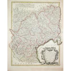
Carte des Gouvernements de Languedoc, de Foix et de Rousillon avec la Partie Oreintale du Gouvernement de Guienne.
Jean Lattré, Paris-based engraver and publisher. Worked with Robert de Vaugondy, J. Janvier and R. Bonne. " Atlas Monderne', 1771, 1783 , 1793. Rigobert Bonne (1727...
Place & Date: Paris, 1783.
Selling price: $120
Sold