Browse Listings in Europe > British Isles > British Counties
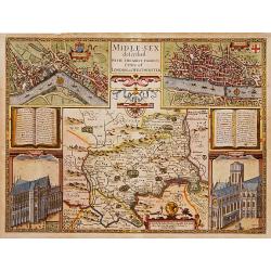
Middle-Sex described with the most famous cities of London and Westminster.
One of the most famous and sought-after of Speed's County maps. The County of Middlesex surrounded by a splendid border incorporating a plan of Westminster and London. In...
Place & Date: London 1610-23
Selling price: $1950
Sold
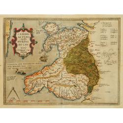
Cambriae Typus..
Ancient map of Wales, prepared by Humphrey Lhuyd. With fine cartouche, ship and a sea monster.
Place & Date: Antwerp 1579
Selling price: $390
Sold
De Zee Custen tuschen Dovere eñ Orfordts nesse, daer de Teemse de Vermaerde Riviere vã Lõnen gelegens is, met alle sanden ondiepte, naer haren wesen eñ ghedaente / Orae maritimae inter Doverium et Ortfortnissam &tc.
Lucas Janszoon Waghenaer (1533/4-1606) published in 1583 his famous pilot-guide ' Spieghel der Zeevaerdt', the first printed pilot-guide with charts, in 1592 he published...
Place & Date: Leiden, 1585
Selling price: $1850
Sold in 2008
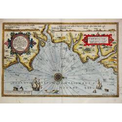
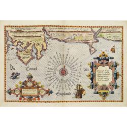
Zee caerte van Engelants Eijndt, Alsoe hem tselfde Landt verthoont beginnende van Sorlinges tot Pleijmondt . . .
A detailed chart of the sea coast of England, from the Sorlinges islands to the Plymouth region along the English Channel decorated by a very colorful title cartouche and...
Place & Date: Leiden, Plantijn, 1585
Selling price: $2200
Sold in 2009
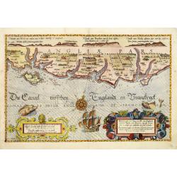
Befchrijvinghe der Zee, custen van Engelandt, tusschen Pleijmouth en Porthlandt. . .
A detailed chart of the sea coast of England, from Plymouth region along the English Channel to Portland decorated by a very colorful title cartouche and scale cartouche,...
Place & Date: Leiden, Plantijn, 1585
Selling price: $2400
Sold in 2009
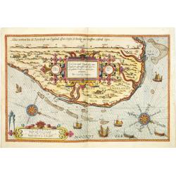
Befchrijvinghe der Zeecusten van Engelandt tusschen Wicht ende Doveren. . .
A detailed chart of the English channel coastland, from the island of Wight to Dover. Decorated by a very colorful title cartouche and scale cartouche, one compass rose, ...
Place & Date: Leiden, Plantijn, 1585
Selling price: $3400
Sold in 2008
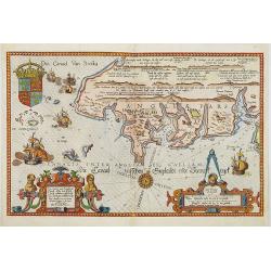
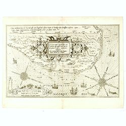
Zee Caerte vande Noordt custe van Engelandt, alsoe tzelffde landt aldaer. . .
A detailed chart of the northern coast of England. Decorated by a colorful title cartouche and scale cartouche, one compass rose, several vessels. A very early edition ra...
Place & Date: Leiden, Plantijn, 1585
Selling price: $2600
Sold in 2008
Zee Caerte vande Noordt custe van Engelandt, alsoe tzelffde landt aldaer. . .
A detailed description of the northern coast of England. Decorated by a title cartouche and scale cartouche, one compass rose, several vessels. A very early edition rare ...
Place & Date: Leiden, Plantijn, 1585
Selling price: $1000
Sold in 2016
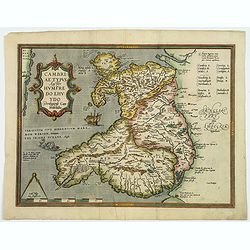
Cambriae Typus Auctore Humfredo Lhuydo Denbigiense Cambrobritano.
A beautiful hand colored copper-engraved map of Wales. It is the first separately printed map of Wales, by Humphrey Lhuyd. This is the second variant of the Ortelius publ...
Place & Date: Antwerp, ca 1595
Selling price: $120
Sold in 2019
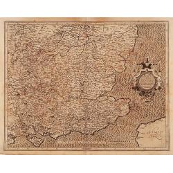
Warwicum Northamtonia Huntingdonia Cantabrigia..
A map of the south-eastern part of England.Mercator was born in Rupelmonde in Flanders and studied in Louvain under Gemma Frisius, Dutch writer, astronomer and mathematic...
Place & Date: Amsterdam 1606
Selling price: $140
Sold