Browse Listings in Europe > British Isles
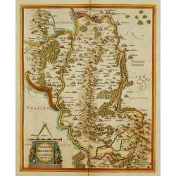
Udrone Irlandiae in Catherlagh Baronia.
Depicts present day County Carlow in Leinster Province & Catherlaugh which is now Carlow. The title is surrounded by a strap work design cartouche topped with caliper...
Place & Date: Amsterdam 1639-44.
Selling price: $160
Sold
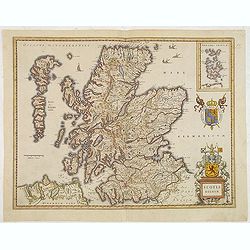
Scotia Regnum.
A attractive example of this fine map of Scotland.
Place & Date: Amsterdam, ca.165
Selling price: $260
Sold in 2013
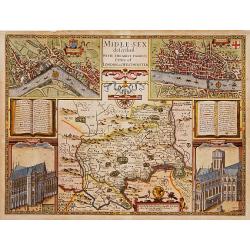
Middle-Sex described with the most famous cities of London and Westminster.
One of the most famous and sought-after of Speed's County maps. The County of Middlesex surrounded by a splendid border incorporating a plan of Westminster and London. In...
Place & Date: London 1610-23
Selling price: $1950
Sold
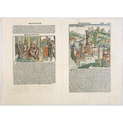
Anglie Provincia (Tercia estas mundi Foliu XLVI ) / Salomon's genealogy tree (XLVI) / Genealogy tree & Abner & Joab (XLVII) / Judgment of Solomon (XLVII).
Woodcuts depicting an imaginary England countryside, showing a fortified city above a fast-flowing river. According to Rodney Shirley "[the two woodcuts] are masterf...
Place & Date: Nuremberg, 12 July 1493
Selling price: $800
Sold in 2020
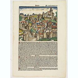
Anglia Fo CCLXXXVIIII (Town in England)
Text page in latin on recto a hill-side city in England with a series of gates leading up to a citadel. It is one of two woodcuts used for England in the work. On the rer...
Place & Date: Nuremberg, 12 July 1493
Selling price: $500
Sold in 2017
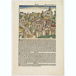
Anglia / Hispania. Fo CCLXXXVIIII.
Text page in Latin on recto a hill-side city in England with a series of gates leading up to a citadel. It is one of two woodcuts used for England in the work. On the ver...
Place & Date: Nuremberg, 12 July 1493
Selling price: $325
Sold in 2017
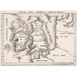
Tabula nova Hibernie Anglie et Scotie.
Martin Waldseemuller's issue of "Geographia," published in 1513 and 1520, was one of the most important atlases of the first half of the sixteenth century as th...
Place & Date: Strasbourg, 1513-1520
Selling price: $4000
Sold in 2009
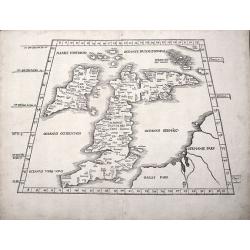
TAB I EURO PRINCIPIUM EUROPAE....TABULA I EUROPAE
Martin Waldseemuller's edition of the classical cartography of Claudius Ptolemy that had first appeared in 1513.The British Isles, set in a trapezoid frame this woodblock...
Place & Date: Stassburg, 1522
Selling price: $2500
Sold in 2012
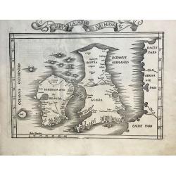
Tabula Moderna Hiber.
One of the Earliest obtainable Modern Maps of the British Isles. A nice example of the 1525 edition of Lorenz Fries's double-page woodblock modern map of the British Isl...
Place & Date: Strasbourg, 1525
Selling price: $1300
Sold in 2021
![[Map of the British Isles]](/uploads/cache/40500-250x250.jpg)
[Map of the British Isles]
First edition Inghilterra.Rare: A very early woodblock map of the British Isles by the Italian cartographer Benedetto Bordone, an 16th century illuminator and wood engrav...
Place & Date: Venice, 1528
Selling price: $650
Sold in 2017