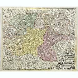
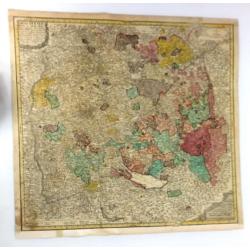
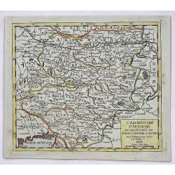
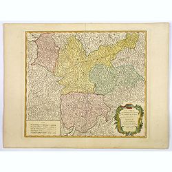
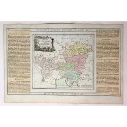
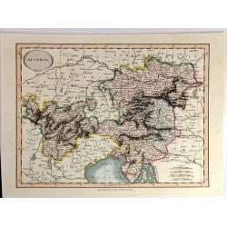
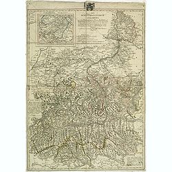
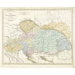
Archiducatus Austriae inferioris . . .
Decorative map of Austria, centered on the course of the Danube River and Vienna. Shows the region from Enss and sTeyr to Presburg and Altenburg.
Date: Nuremberg, 1724
Selling price: ????
Please login to see price!
Sold in 2014
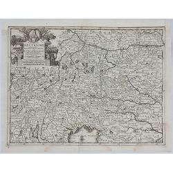
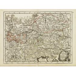
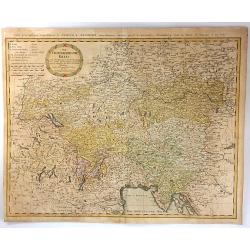
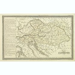
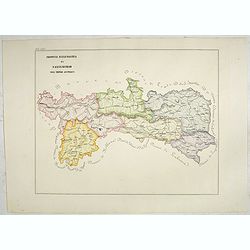
Cercle D'Autriche suivant les Nouvelles Observations.
An attractive, detailed map of Austria, part of Italy and the Czech Republic. Features a decorative cartouche with arms and a native holding a spear. Also portrait of a p...
Date: Amsterdam, 1729
Selling price: ????
Please login to see price!
Sold in 2021
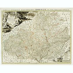
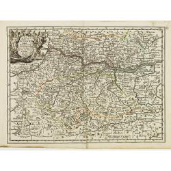
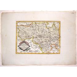
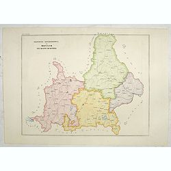
Carte générale du marquisat de Moravie..
Very detailed map of Moravia.
Date: Amsterdam, 1730
Selling price: ????
Please login to see price!
Sold
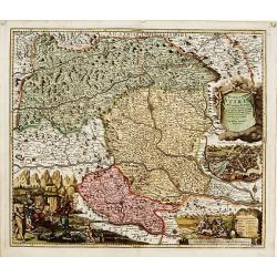
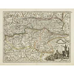
Ducatus Stiriae novissima Tabula.
"Showing Stiria in Austria, centered on Grütz, with to the right an inset with a bids-eye view of the town. Lower left and right splendid cartouches The car...
Date: Nurenberg 1740
Selling price: ????
Please login to see price!
Sold
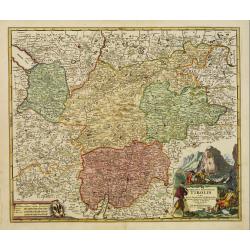
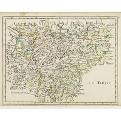
Comitatus Principalis Tirolis..
Very fine and detailed map of Tyrol, covering the towns of Kuffstein, Innsbruck, western part of Boden See, and as far south as tip of Lake Garda with the Italian area Tr...
Date: Nuremberg 1740
Selling price: ????
Please login to see price!
Sold in 2009
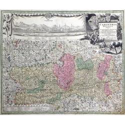
Carinthia Ducatus destineta in Superiorem, et Inferior. Cum infertis Dominiis ad Archiep Salisburgens et Episcop. Bambergensis pertinentibus nova mappa Geographica ob oculos et venum exposita per Matth. Seutter.
Decorative map of the region of the duchy of Carinthia in southern Austria bordering the eastern Alps. The map shows many details of the regions, such as mountains, abbey...
Date: Augsburg, 1730-1740
Selling price: ????
Please login to see price!
Sold in 2010
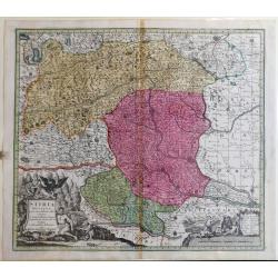
Stiria Ducatus
A fine map of Stiria /Austria includes Graz, Wiener Neustadt (Vienna Newtown), down to Croatia.
Date: Augusburg, ca 1740
Selling price: ????
Please login to see price!
Sold in 2023
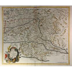
Le Duché de Stirie Suivant les Dernières Observations
The map shows the area of the Steiermark in Austria, comprising Sofron, Nagykanizsa to the east, the south Krsko, Klagenfurth and Radstadt in the west and in the north of...
Date: Paris, 1742
Selling price: ????
Please login to see price!
Sold in 2023
Circuli Sveviae Mappa ex Subsidijs Mechalanis...
A map of Württemberg and the Swabish principality in Austria. On the left side is Strasberg, on the top is Heidleberg, on the right is Neuberg and on the bottom is Zuric...
Date: Nuremberg, 1743
Selling price: ????
Please login to see price!
Sold in 2016
Le duché de Stirie. . .
Fine map of part of Austria with a splendid cartouche. George Louis Le Rouge was active between 1740 and 1780, in Paris at, rue des Augustins as a publisher, and was appo...
Date: Paris, 1744
Selling price: ????
Please login to see price!
Sold in 2016
L'Archeveché de Saltzbourg dedié A S.A.S. Monseigneur le Prince de Conty, . .
Fine map of part of Austria and centered on Salzburg with a splendid title, scale and key cartouches. George Louis Le Rouge was active between 1740 and 1780, in Paris at,...
Date: Paris, 1744
Selling price: ????
Please login to see price!
Sold in 2016
La Basse Autriche.
Fine detailed map of lower Austria by Le Rouge. Features a cartouche depicting a battle between soldiers.George Louis Le Rouge was active from 1740- till 1780 as a publis...
Date: Paris, 1748
Selling price: ????
Please login to see price!
Sold in 2018
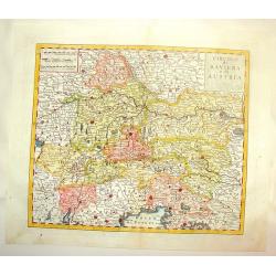
L'Archiduche D'Autriche et les Duches de Stirie, Cartinthie et Carniole.
A fine map of Inner Austria, or currently Austria, Slovenia and Hungary. This region referred to the Duchies and Habsburg hereditary lands. It was published in the 1748 e...
Date: Paris, 1748
Selling price: ????
Please login to see price!
Sold in 2017
Principatus Silesiae Teschinensis nova et accurata delineatio distincte insimul exhibens Status minores. . .
Detailed map centered on the Duchy Teschen in Austrian Silesia. Published in Atlas Silesiae Id Est Ducatus Silesiae Generaliter Quatuor Mappis Nec Non Specialiter XVI Map...
Date: Nuremberg, 1736 / 1750
Selling price: ????
Please login to see price!
Sold in 2012
Partie Septentrionale du Cercle d'Autriche..
Detailed map of Austria, with an ornamental cartouche. Relief shown pictorially.
Date: Paris 1752
Selling price: ????
Please login to see price!
Sold
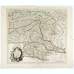
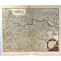
Partie Septentrionale du Cercle D'Autriche Qui Comprend L'Archiduche D'Autriche.
A pleasing map of North Austria centered around the Danube River which flows through the top part of the map through Vienna. Large title cartouche is featured in the righ...
Date: Paris, 1752
Selling price: ????
Please login to see price!
Sold in 2018
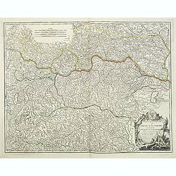
Partie Septentrionale du Cercle D'Autriche
A fine map of northern Austria by Robert de Vaugondy. It covers from Radstadt north to Scharding and east as far as Bratislava.The entire region is depicted in detail, of...
Date: Paris, 1752
Selling price: ????
Please login to see price!
Sold in 2017
Partie Septentrionale du Cercle d'Autriche. . .
Detailed map of Austria, with an ornamental cartouche. Relief shown pictorially from his "Atlas Universel".Gilles Robert de Vaugondy (1688–1766), also known a...
Date: Paris 1752
Selling price: ????
Please login to see price!
Sold
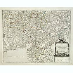
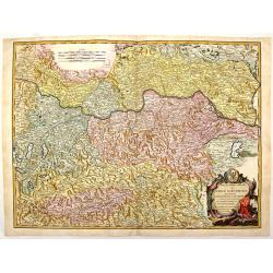
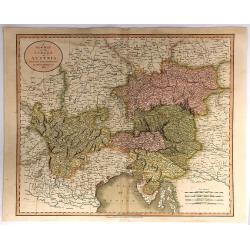
Partie Méridionale du Cercle d'Autriche. . .
Detailed map of Austria, with an ornamental cartouche. Relief shown pictorially from his "Atlas Universel".Gilles Robert de Vaugondy (1688–1766), also known a...
Date: Paris 1752
Selling price: ????
Please login to see price!
Sold in 2019
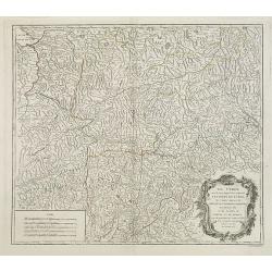
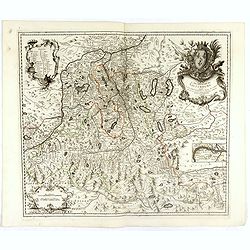
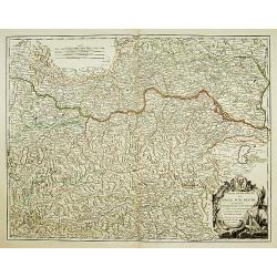
Le Tyrol sous le nom duquel. . .
De Vaugondy's large map of the mountainous Tirol region spanning portios of northern Italy, eastern Switzerland, and western Austria from his "Atlas Universel"....
Date: Paris 1753
Selling price: ????
Please login to see price!
Sold in 2016
Le Tyrol sous le nom duquel. . .
Robert de Vaugondy's large map of the mountainous Tirol region spanning portions of northern Italy, eastern Switzerland, and western Austria from his "Atlas Universe...
Date: Paris, 1753
Selling price: ????
Please login to see price!
Sold in 2020
Le Cercle d'Autriche.
Fine map of Austria. It presents a decorative title cartouche and a cartouche depicting knights whose impression is slightly faded. George Louis Le Rouge was active from ...
Date: Paris 1756
Selling price: ????
Please login to see price!
Sold
La Haute Autriche..
Fine map of the western part of Austria with a decorative title cartouche. George Louis Le Rouge was active from 1740- till 1780 as a publisher, and was appointed enginee...
Date: Paris 1756
Selling price: ????
Please login to see price!
Sold
La Basse Autriche.
Fine map of the eastern part of Austria with a decorative title cartouche. George Louis Le Rouge was active from 1740- till 1780 as a publisher, and was appointed enginee...
Date: Paris 1756
Selling price: ????
Please login to see price!
Sold
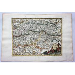
Le Tirol.
Fine map of Tyrol. In lower part Lake Garda and in upper right the skiing grounds of Innsbruck, Kuffstein, etc.George Louis Le Rouge was active from 1740- till 1780 as a ...
Date: Paris 1756
Selling price: ????
Please login to see price!
Sold
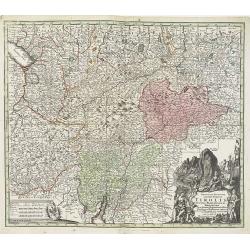
Principali Dignitate Gaudens Comitat. Tirolis Episcopat. Tridentinum et Brixiensem ut et Comitat. Brigantinum Feldkirch Sonneberg et Pludentinum contingens quo ad omnes Urbes. . .
The mountainous borders of Italy, Switzerland & Austria, with an allegorical title cartouche lower right. Centered on the course of the Inn River and including Lake G...
Date: Nuremberg, ca. 1760
Selling price: ????
Please login to see price!
Sold in 2020

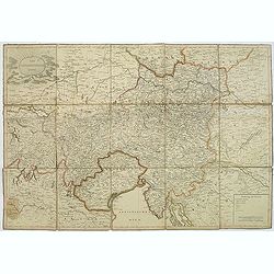
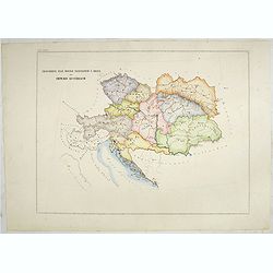
Circuli Austriaci pars Septentrionalis in qua Archiducatus. . .
Decorative and detailed map of Austria, here in a second state with the address of Jean Covens and Cornelis Mortier.The Amsterdam publishing firm of Covens and Mortier (1...
Date: Amsterdam, c. 1760
Selling price: ????
Please login to see price!
Sold in 2011
Circulo di Baviera e di Austria.
Fine, detailed, copper engraved map of Bavaria & Austria. Two block style cartouches, by Albrizi after I. Tirion.Giambattista Albrizzi (1698-1777) was a Venetian publ...
Date: Venice, from 1740-1762
Selling price: ????
Please login to see price!
Sold in 2016
![[No title] Carte générale d'Allemagne divisée et numérotée...des postes et autres routes de cet empire.](/uploads/cache/29330-250x250.jpg)
[No title] Carte générale d'Allemagne divisée et numérotée...des postes et autres routes de cet empire.
Map of Istria, part of Austria and Hungary.A so called post road mapspost route map.Desnos, born in a small village close to Beauvais, was apprenticed to Joseph-Simon Gui...
Date: Paris, 1766
Selling price: ????
Please login to see price!
Sold in 2011
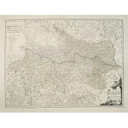
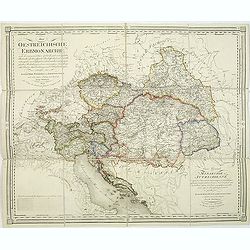
Der Oesterreichische Kreis.
The map shows the ancient Austrian Empire with the Duchy of Austria, Styria, KŠrnten, Krain (Slowenia) Istria, Tyrol, and diocese Trient. In 1716, Homann published his m...
Date: Nuremberg, 1788
Selling price: ????
Please login to see price!
Sold in 2016
Carte D'Austriche Divisee en Toutes ses Provinces...
An attractive and informative map of Austria by French cartographer, Louis Brion de la Tour. It notes numerous towns, cities, rivers, forests, mountains and other topogra...
Date: Paris, 1790
Selling price: ????
Please login to see price!
Sold in 2018
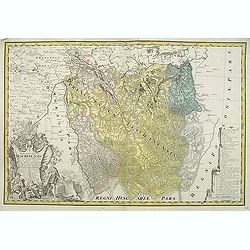
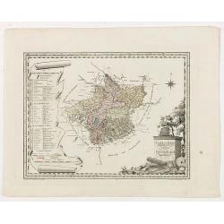
Die Markgraftschaft in ihre Kreise Eingetheilt Nro. 103.
Nice detailed copper engraved map of the Margraviate of Lustia divided into parts. Embellished with a unique diamond-shaped, ribboned cartouche.Joseph von Reilly (1766–...
Date: Vienna, 1791
Selling price: ????
Please login to see price!
Sold in 2016
Karte von dem Erzherzogthum Oesterreich.
An attractive oversized map of Austria. With a decorative title cartouche in the lower right-hand corner and a legend on the left side.Franz Johann Josef von Reilly (Vien...
Date: Vienna, 1796
Selling price: ????
Please login to see price!
Sold in 2012
Natur und Kunst Producten karte von Oestreich Obderens.
Rare map that shows the locations of the factories or growing areas of "natural products". The title cartouche at the bottom right, the explanations of symbols ...
Date: Vienna, 1796
Selling price: ????
Please login to see price!
Sold in 2020
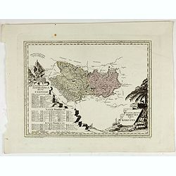
Natur und Producten Karte von Kaernten.
Nature and products map of Carinthia. Map of J.W. Engelmann after H.W. von Blum, taken from "Natur und Kunst Producten Atlas der Oesterreichischen, deutschen Staaten...
Date: Viena, 1796
Selling price: ????
Please login to see price!
Sold in 2022
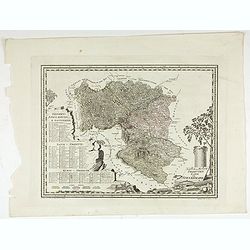
Natur und Producten Karte von Steyermark.
Nature and products map of Styria. Map of J.W. Engelmann after H.W. von Blum, taken from "Natur und Kunst Producten Atlas der Oesterreichischen, deutschen Staaten&qu...
Date: Viena, 1796
Selling price: ????
Please login to see price!
Sold in 2022
Austria By John Cary
A fine map of Austria and Slowenia. John Cary (1754 –1835) was an English cartographer. He served his apprenticeship as an engraver in London, before setting up his own...
Date: London, 1801
Selling price: ????
Please login to see price!
Sold in 2015
Der Osterreichische Kreiss. Nach dem neusten Grenz=Berichtigung verlast.
Folding map of Austria, engraved by F. Reisser and published by Tranquillo Mollo in Vienna. Maria Laurentio Tranquillo Mollo (born August 10, 1767 in Bellinzona, Ticino, ...
Date: Vienna, 1803
Selling price: ????
Please login to see price!
Sold in 2013
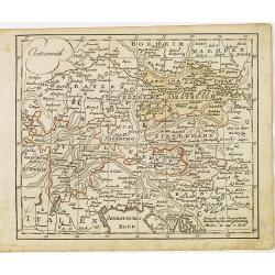
Das Kurfüstenthum Salzburg. . .
Map of Salzburg in Austria. Many annotation in black lead-pencil. More about folding maps. [+]
Date: Nurmberg, 1805
Selling price: ????
Please login to see price!
Sold in 2013
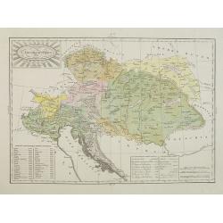
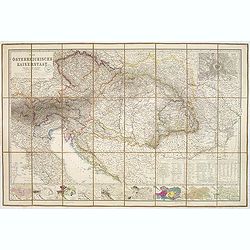
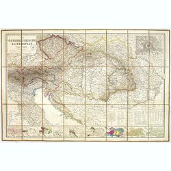
Die Oestreichische Erbmonarchie nach ihrem gegenwärtigen Zustande Kartenmaterial mit vorzüglicher Rücksicht auf ihre physische Beschaffenheit. . . / Carte générale de la monarchie autrichienn.
Detailed map showing Central Europe and showing the Austria-Hungarian Monarchy. The map includes Austria, with parts of Poland, Germany, Italy, prepared by Joseph Wüstin...
Date: Vienna, Kunst und Industrie Comptoirs,1806
Selling price: ????
Please login to see price!
Sold in 2013
A New Map of the Circle of Austria, From the Latest Authorities . . .
A detailed map of John Cary’s Austria, from the important early 19th century “NEW UNIVERSAL ATLAS”. It covers from Lake Constance and eastward as far as Lake Pelso...
Date: London, 1811
Selling price: ????
Please login to see price!
Sold in 2018
Oesterreich.
Nice small map of Austria by Johannes Walch in his rare Allgemeiner Atlas Nach den bewährsten Hülfsmitteln und astronomischen Ortsbestimungen…, edition of 1812.Johann...
Date: Augsburg, 1812
Selling price: ????
Please login to see price!
Sold in 2015
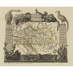
Autriche
Attractive map of Austria with decorative borders depicting typical artifacts and produce of the continent. Published in Les jeunes voyageurs en Europe.. . Engraved by va...
Date: Brussels, 1824
Selling price: ????
Please login to see price!
Sold in 2013
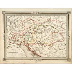
Empire d'Autriche.
Finely engraved map of Austria prepared by A.H.Dufour and engraved by Giraldon-Bovinet. Published by Jules Renouard in his uncommon atlas "Le globe Atlas classique U...
Date: Paris, Jules Renouard, ca.1840
Selling price: ????
Please login to see price!
Sold in 2011
L'Impero Austriaco . . .
A rare and detailed double-page map of Austrian Empire, including Northern Italy, Hungary, Czech Republic, etc. From l'Atlante Storico, Letterario, Biografico, Archeologi...
Date: Venice, 1840
Selling price: ????
Please login to see price!
Sold in 2014
Empire d'Autriche..
Decorative map of Austria, prepared by J.G.Barbié du Bocage.Engraved by Ch.Smith, published by Basset who was established in Paris, rue de Seine 33. From atlas Illustré...
Date: Paris 1846
Selling price: ????
Please login to see price!
Sold
Karta öfver Österrike.
An very rare map of Austria, including present-day Hungary, Poland, Northern Italy, Trieste, the Dalmatian coast (with inset) with Swedish text. This is an updated versio...
Date: A. Wiborgs förlag, Stockholm, ca. 1848
Selling price: ????
Please login to see price!
Sold in 2016
Austria.
A striking hand-colored lithographed map of Austria by Montegue. It features inserted vignettes of the city of Vienna, the Fortress of Komorn and Croatian Irregular Troop...
Date: London, ca 1850
Selling price: ????
Please login to see price!
Sold in 2019
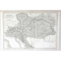
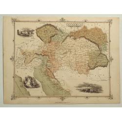
Austrian Dominions
A fine map of the Austrian empire, covering the territories claimed by the once vast Austrian empire, including in whole or part the modern day nations of Austria, Hungar...
Date: London, 1851
Selling price: ????
Please login to see price!
Sold in 2016
Circoscrizione delle province ecclesiastiche e diocesi nell Impero austriaco (Tav LXIV)
This large-format map of Austria with it different dioceses. The map is finely engraved and beautifully colored and was prepared by Girolamo Petri, a lawyer who served as...
Date: Rome, 1858
Selling price: ????
Please login to see price!
Sold in 2019
Provincia ecclesiastica di Salisburgo nell' Impero Austriaco (Tav LXVI)
A large-format map of Austria / Salzburg with it different dioceses. The map is finely engraved and beautifully colored and was prepared by Girolamo Petri, a lawyer who s...
Date: Rome, 1858
Selling price: ????
Please login to see price!
Sold in 2019
Province ecclesiastica di Monaco nel regno di Baviera (Tav LXXVII)
This large area of southern Germany, centered on Regensburg and western Austria, with the tip of Lake Constance to the left.The map is finely engraved and beautifully col...
Date: Rome, 1858
Selling price: ????
Please login to see price!
Sold in 2021
Der Osterreichische Kaiserstaat Entworfen von Herm. Berghaus. . .
Very detailed large-scale 19th century folding map of Austria, published in the birth year of Franz Ferdinand, became Archduke of Austria. Covers from Northern part of It...
Date: Gotha, Justus Perthes, 1863
Selling price: ????
Please login to see price!
Sold in 2014
Der Osterreichische Kaiserstaat Entworfen von Herm. Berghaus. . .
Very detailed large-scale 19th century folding map of Austria, published in the birth year of Franz Ferdinand, became Archduke of Austria. Covers from Northern part of It...
Date: Gotha, Justus Perthes, 1863
Selling price: ????
Please login to see price!
Sold in 2023
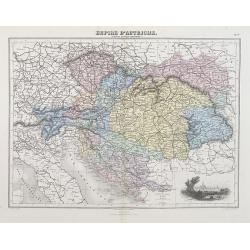
Empire d'Autriche (Empire Autro-Hongrois).
A decorative map of Austria and Hungary from Géographie Universelle, Atlas Migeon, published by J. Migeon. With an engraving of Vienna lower right corner.From one of the...
Date: Paris, 1874
Selling price: ????
Please login to see price!
Sold in 2012
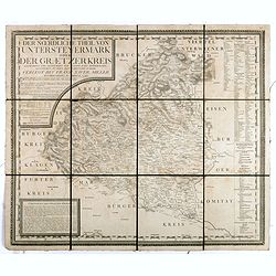
Der noerdliche Theil von Untersteyermark oder der Graetzer Kreis, Entworfen und gezeichnet von Joseph Karl Kindermann
Beautiful, rare and decorative copper engraved map of Styria, Austria. Prepared by Jos. Karl Kindermann, engraved by Christoph Junker in Vienna and published by Xavier Mi...
Date: Graetz, 1789-1894
Selling price: ????
Please login to see price!
Sold in 2018
