Browse Listings in Europe
![Die ander Tafel des Rheinstromes, begreiffendt die Pfaltz, Westereich, Eyfel,sc. [Course of the Rhine from approx. Strassbourg to Andernach]](/uploads/cache/84787-250x250.jpg)
Die ander Tafel des Rheinstromes, begreiffendt die Pfaltz, Westereich, Eyfel,sc. [Course of the Rhine from approx. Strassbourg to Andernach]
Wood block map of a part of the course of the Rhine and surrounding lands, by Sebastian Munster.One of the Earliest Modern Maps of the Rhine river. This map is the second...
Place & Date: Basel 1550 ca.
Selling price: $130
Sold in 2020
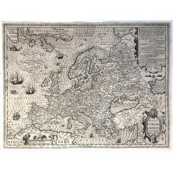
Nova Europae Descriptio.
A fine uncolored version of Hondius' second map of Europe, first issued in 1606. From: Jodocus Hondius, 'Atlas sive cosmographicæ meditationes de fabrica mundi et fabric...
Place & Date: Amsterdam, 1621-/23
Selling price: $615
Sold in 2020
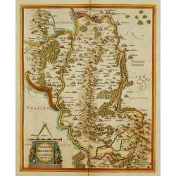
Udrone Irlandiae in Catherlagh Baronia.
Depicts present day County Carlow in Leinster Province & Catherlaugh which is now Carlow. The title is surrounded by a strap work design cartouche topped with caliper...
Place & Date: Amsterdam 1639-44.
Selling price: $160
Sold
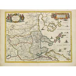
Thessaliae accurata descriptio.
A map of northeast of Greece in classical times by the hand of Johannes Laurenberg appeared in part V of Johannes Janssonius? ?Atlantis Majoris?.Embellished with two deco...
Place & Date: Amsterdam, 1650-57.
Selling price: $260
Sold
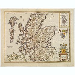
Scotia Regnum.
A attractive example of this fine map of Scotland.
Place & Date: Amsterdam, ca.165
Selling price: $260
Sold in 2013
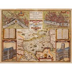
Middle-Sex described with the most famous cities of London and Westminster.
One of the most famous and sought-after of Speed's County maps. The County of Middlesex surrounded by a splendid border incorporating a plan of Westminster and London. In...
Place & Date: London 1610-23
Selling price: $1950
Sold
![Partie septentrionale du cercle de Haute Saxe [...] Brandebourg.](/uploads/cache/36760-250x250.jpg)
Partie septentrionale du cercle de Haute Saxe [...] Brandebourg.
Finely and crisply engraved map of north eastern part of Germany, including part of Poland. With inset map of Brandenburg. Prepared by Giles Didier Robert De Vaugondy wit...
Place & Date: Venice, 1178
Selling price: $20
Sold in 2016
![Florencia. [Florence]](/uploads/cache/14367-250x250.jpg)
Florencia. [Florence]
A very fine view of Florence. Verso showing the genealogy of the Syrian kings and priests.Page from the richest illustrated Incunable, the famous: Liber chronicarum or Nu...
Place & Date: Nuremberg, 12 July 1493
Selling price: $2500
Sold in 2011
![Neapolis [Naples] Folium XLII](/uploads/cache/12287-250x250.jpg)
Neapolis [Naples] Folium XLII
A imaginary view of Naples (19x22cm.), however the earliest obtainable view of this period.Page from the richest illustrated Incunable, the famous: Liber chronicarum or N...
Place & Date: Nuremberg, 12 July 1493
Selling price: $350
Sold in 2014
![Sexta Etas Mundi. Patavia. [Passau]](/uploads/cache/13552-250x250.jpg)
Sexta Etas Mundi. Patavia. [Passau]
A very fine presentation of the city of Passau, in Germany, centered on the cathedral (Dim. : 232 mm W : 520 mm).Overleaf, the different kings are depicted.Page from the ...
Place & Date: Nuremberg, 12 July 1493
Selling price: $1500
Sold