Browse Listings in Asia > Thailand / Burma / Vietnam
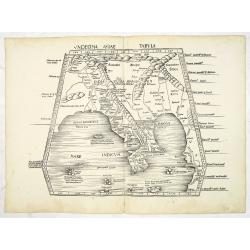
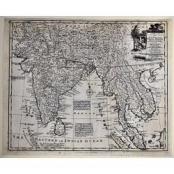
Undecima Asiae Tabula (Bangladesh, Burma, India, Thailand)
Wood block printed large-format Ptolemaic map showing Bangladesh, Burma, India, Thailand, from the 1513 edition of Waldseemüller's Geographia.Showing region east of the ...
Place & Date: Strasburg, 1513
Selling price: $2700
Sold in 2013
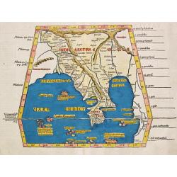
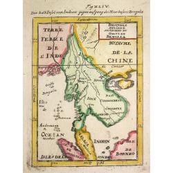
Tabula IX Asia (map of Bengal and Burma.).
Laurent Fries reduced version of Martin Waldseemüller’s map of Ptolemy’s ninth map of Asia, depicting northeast India and Birma. Martin Waldseemüller (1470-1521) dr...
Place & Date: Lyon, 1535
Selling price: $275
Sold in 2019
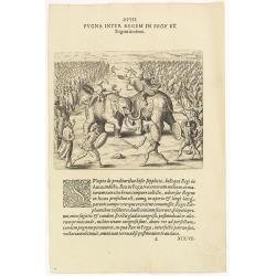
XVIII. Pugna Inter Regem in Pegu . . . [A battle between King Pegu and King Auua)
Battle with two elephants between King Pegu and King Auua. After King Pegu had burnt the traitors, he gathered together three hundred thousand men and declared war on Kin...
Place & Date: Frankfurt, 1599
Selling price: $75
Sold in 2016
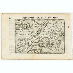
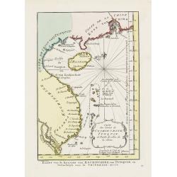
Descriptio Arachan et Pegu / Aracam.
A rare miniature map of Thailand. Title cartouche on the upper left corner.First published in 1598 in his Caert-Thresoor, the plates were executed by the most famous engr...
Place & Date: Amsterdam, Cornelis Claes, 1606
Selling price: $200
Sold in 2016
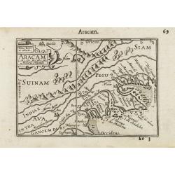
Aracam.
A miniature map of Burma, orientated with north to the left, with Pegu. Title cartouche on the upper left corner.First published in 1598 in his Caert-Thresoor, the plates...
Place & Date: Amsterdam / Frankfurt, 1609
Selling price: $120
Sold in 2012
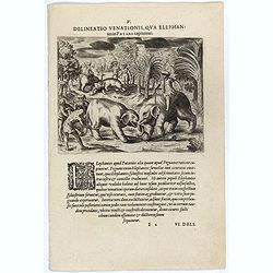
Delineatio Venationis, Qua Elephantes Patane Capiuntur. (Capturing elephants)
A fine early illustration of capturing elephants in Pegu Kingdom.Theodore de Bry, a German engraver and book dealer, began a compilation of early voyages in 1590 and had ...
Place & Date: Frankfurt, 1609
Selling price: $90
Sold
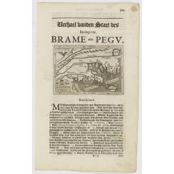
Arachan & Pegu.
Small map illustrating part of the Martaban seacoast belonging to today Myanmar. Surrounded by text in Dutch.Nicolaes de Clerck (de Klerc) was active as engraver and publ...
Place & Date: Amsterdam, Cloppenburch, 1621
Selling price: $120
Sold
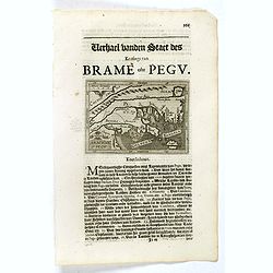
Arachan & Pegu.
Small map illustrating part of the Martaban seacoast belonging to today Myanmar. Surrounded by text in Dutch.Nicolaes de Clerck (de Klerc) was active as engraver and publ...
Place & Date: Amsterdam, Cloppenburch, 1621
Selling price: $140
Sold in 2019
Royaume d'Annan Comprenant Les Royaumes de Tumkin et de la Cocinchine Designé par les Peres de la Compagnie de Iesus
Engraved by Somer. Map of the region from Macao to Laos and Cambodia, centered on Vietnam, Annam and Tonkin region. One of the earliest maps of the region in detail, incl...
Place & Date: Paris, 1650
Selling price: $750
Sold in 2011
Royaume d'Annan Comprenant Les Royavmes de Tvmkin et de..
Showing the Indo China coast till Macao. Engraved by Somer. RARE.
Place & Date: Paris, 1650
Selling price: $750
Sold in 2011
Royaume d'Annan, comprenant les royaumes de Tumkin et de la Cocinchine / désigné par les peres de la Compagnie de Jesus. . .
Showing the Indo China with Vietnam and small portion of southeastern China with coastline till Macao. Engraved by Somer. RARE.
Place & Date: Paris, 1650
Selling price: $900
Sold in 2012

Daniel Taverniers Land Charte des KönigreichsTUNQUIN.
Covers northern parts Vietnam. From a German edition of Travernier's travel book. According to Cox: Travernier ... Wil always continue among the most valuable travellers ...
Place & Date: Nuremberg 1681
Selling price: $340
Sold
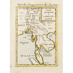
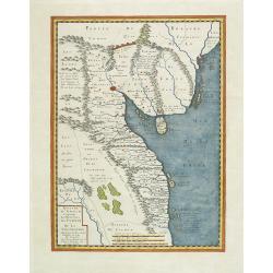
Inde Ancienne A L'Orient Du Gange.
A charming late 17th century French map of the area east of Ganges River, covering Myanmar, Thailand, Cambodia, Laos, Vietnam, part of Malaysia and Sumatra.By Allain Mann...
Place & Date: Franckfurt 1684
Selling price: $80
Sold
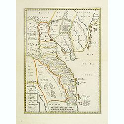
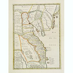
Presqu'isle de l 'lnde a l' Orient de Bengala.
Alain Manneson Mallet (1603-1706) published in 1683 his ' Description de l' Univers' in 5 volumes. In 1686 a German edition appeared.A map from Alain Manesson Mallet's 'D...
Place & Date: Paris, 1686
Selling price: $105
Sold in 2008

Voyage de Siam des pères jesuites envoyés par le roy, aux Indes & à la Chine.
Third edition. Covers the voyage from Brest to Siam, and the ports of stop in between. The majority of the work is on Siam, but an interesting portion also on Batavia and...
Place & Date: Amsterdam, P.Mortier, 1688
Selling price: $1200
Sold in 2018
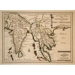
Les Vrays Indes dits Grands Indes ou Indes Orientales
Striking map of India and the Malaysian Peninsula, showing excellent detail throughout. From De Fer's Atlas Curieux. Nice wide margins and decorative cartouche.
Place & Date: Paris, 1705
Selling price: $250
Sold in 2009
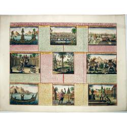
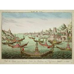
VUE & DESCRIPTION DE LA VILLE DE SIAM . . .
A copper engraved sheet with set of 9 decorative views of Thailand, including the king of Siam riding on his elephant. A very decorative item ! - It features the capital ...
Place & Date: Amsterdam, ca 1715
Selling price: $220
Sold in 2021
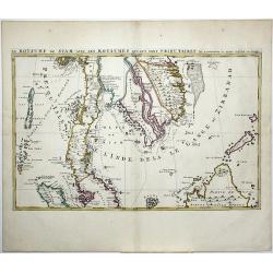
Le Royaume de Siam avec Les Royaumes Qui Luy sont Tributaries & c.
Part of Mortier's large Format multiple sheet Map of the Kingdom of Siam, Malaysian Peninsula, Singapore, Indonesia, etc. A gorgeous full color example of Pierre Mortier'...
Place & Date: Amsterdam, ca 1720
Selling price: $160
Sold in 2021
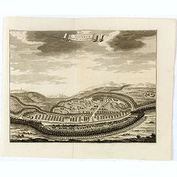
![Eauweck. Hoofdstad van Cambodia. [Lawec]](/uploads/cache/25002-250x250.jpg)
Eauweck. Hoofdstad van Cambodia. [Lawec]
Decorative panoramic view of the town of Lawec in Cambodia. The city of shown in the centre of this illustration and is surrounded by hills, forests and a river.François...
Place & Date: Amsterdam, 1726
Selling price: $80
Sold
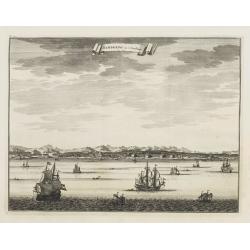
Samboepo in 't Verschiet.
Decorative panoramic view of the town of Samboupo on the island of Celebes (Sulawesi) in today's Indonesia. Dutch (V.O.C.) sailing ships and various local craft fill the ...
Place & Date: Amsterdam, 1726
Selling price: $80
Sold
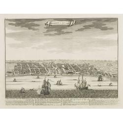
Samboepo in platte Grond.
Decorative panoramic view of the town of Samboupo on the island of Celebes (Sulawesi) in today's Indonesia. Dutch (V.O.C.) sailing ships and various local craft fill the ...
Place & Date: Amsterdam, 1726
Selling price: $70
Sold in 2009
Eauweck. Hoost Stad van Cambodia.
Map shows the jungle city in Cambodia.François Valentijn (1666-1727), a missionary, worked at Amboina from 1684 to 1694 and 1705 to 1713 and travelled extensively in the...
Place & Date: Amsterdam, 1726
Selling price: $100
Sold in 2016
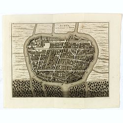
Judia, De Hoofd Stad van Siam.
A rare plan of map of Ayutthaya named "Judia, De Hoofd-Stad van Siam", copied after Johannes Vingboons.François Valentijn (1666-1727), a missionary, worked at ...
Place & Date: Amsterdam, 1726
Selling price: $425
Sold in 2016
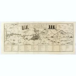
De Groote Siamse Rievier Me-Nam ofte Moeder der Wateren inharen loop met de in vallende Spruyten Verbeeld. . .
Rare map centred on Ayutthaya which town was situated eighty kilometres inland from the mouth of the Gulf of Thailand at the juncture of three rivers. Access required man...
Place & Date: Amsterdam, 1726
Selling price: $545
Sold in 2016
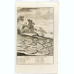
Siamsche Rochevellen.
Engraving of drying sting ray skins on the beach, with below a lettered key A-M.François Valentijn (1666-1727), a missionary, worked at Amboina from 1684 to 1694 and 170...
Place & Date: Amsterdam, 1726
Selling price: $30
Sold in 2017
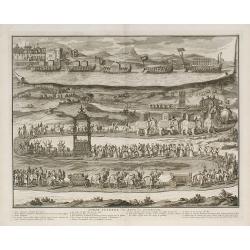
Pompe funèbre des rois de Tunquin.
Place & Date: London, 1729
Selling price: $160
Sold in 2010
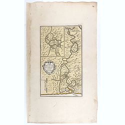
Carte du cours de la Riviere de Meinam depuis Judia jusqui..
Very rare single sheet map of the Meinam river delta from the ancient capital Juthia, shown in inset top left with its continuation on the larger map to the sea. A compli...
Place & Date: Amsterdam, 1737
Selling price: $1000
Sold in 2017
A New and Accurate Map of the Empire of the Great Mogul, Together with India on Both Sides the Ganges, and the Adjacent Countries.
A copper engraved map. Finely engraved map centered on the mouth of the Ganges, and covering India, Pakistan, Thailand, Ceylon, Siam, Laos, Cambodia, part of Tibet, and t...
Place & Date: London, ca. 1747
Selling price: $190
Sold in 2017
Carte des Costes de Cochinchine Tunquin.
Shows today's Vietnam, southern China and Hainan Island in the Gulf of Tonkin. Attractive cartouche and fleur-de-lys.FromAtlas Portatif pour servir a l'intelligence de l'...
Place & Date: Amsterdam, 1749
Selling price: $600
Sold in 2010
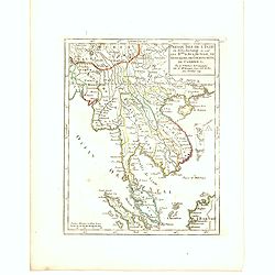
Presqu Isle fr L'Inde au dela du Gange ou sont les R.mes dAva, De Siam, De Tong-King, de Cochinchine de Cambodge, &c. Par le Sr. Robert de Vaugondy fils de Mr. Robert Geog. Ord du Roi avec Privilege 1749.
Small detailed map of Thailand, Cambodia, Malaysia. From Atlas Portatif Universel, by Robert de Vaugondy.Page 165 outside border top right. First and only state.
Place & Date: Paris, 1749
Selling price: $120
Sold in 2016
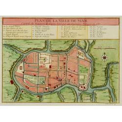
Plan de la ville de Siam.
Early plan of Siam, Thailand. Across the top is an extensive list of 22 important sites and locations keyed to the plan with tiny letters and numbers.Jacques Nicolaas Bel...
Place & Date: Paris 1750
Selling price: $320
Sold
Vue de Siam avec diverses Sortes des Ballons, ou Vaisseaux Chinoise a Rame.
Optical print with view of Thailand.A so-called optical print. In the eighteenth and nineteenth centuries there were many popular speciality establishments in Paris, Augs...
Place & Date: Augsburg, 1750
Selling price: $325
Sold in 2008
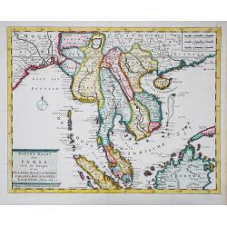
Nieuwe kaart van India over de Ganges, of van Malakka, Siam, Cambodia, Chiampa, Kochinchina, Laos, Pegu, Ava, enz.
Isaac Tirion's attractive map of Indochina, the Malaysian Peninsula and the northern parts of Sumatra and Borneo. The mythical Lac Chaamay is still shown in Acham. Isaak ...
Place & Date: Amsterdam, c. 1750
Selling price: $450
Sold in 2016
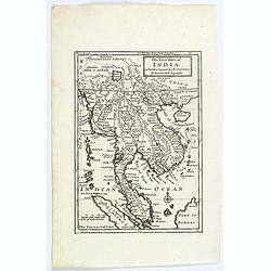
The East Part of India, or India beyond the R. Ganges.
Herman Moll's map of those Asian countries.
Place & Date: London, ca 1750
Selling price: $190
Sold in 2020
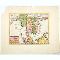
Nieuwe kaart van India over de Ganges, Malakka, Siam..
A nice detailed map, incorporating information provided by French Jesuits, of Indochina, the Malayan peninsular and the northern parts of Sumatra and Borneo. The mythical...
Place & Date: Amsterdam, 1750
Selling price: $90
Sold in 2020
![INDONESIA [Lot of 9 maps] views of the Indonesian archipelago. Carte des Isles de Java, Sumatra Borneo ...](/uploads/cache/IMG_0095-250x250.jpg)
INDONESIA [Lot of 9 maps] views of the Indonesian archipelago. Carte des Isles de Java, Sumatra Borneo ...
Nicolas Bellin's map of the Indonesian archipelago, also depicting Malaysia.Jaques Nicolas Bellin (1702-720) was the most important French hydrographer of the 18th centur...
Place & Date: Paris, c, 1750
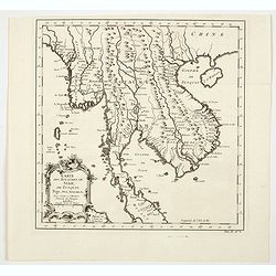
Carte des Royaumes de Siam, de Tunquin, Pegu, Ava, Aracan, &c.
A beautiful map showing the Kingdoms of Siam (Thailand), Aracan, Pegu, and Ava (Burma/Myanmar), Laos, Cambodia and Tunquin (Vietnam). Map extent is from southern China to...
Place & Date: Paris, ca 1750
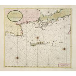
Afteekening van een gedeelte van de kust van Arracam, Pegu en Siam van de rivier Arracam, tot aan de Noordhoek van 't Eyland Sumatra.
Very rare chart of the Andaman Sea and Strait of Malacca. East to the top. In the top the town of Pegu in Miyanmar is shown, than the chart follows the coast of Thailand ...
Place & Date: Amsterdam 1753
Selling price: $3000
Sold
![[2 charts] Kaart van Pulo Condor, of het Eiland Condor.. / Paskaart van de Baay van Padaran op de Kust van Tsiompa..](/uploads/cache/23819-250x250.jpg)
[2 charts] Kaart van Pulo Condor, of het Eiland Condor.. / Paskaart van de Baay van Padaran op de Kust van Tsiompa..
Two finely engraved and detailed charts of Condor Island and the Bay of Pandaran.Very rare: only included in 6th volume (so-called secret atlas) of Van Keulen's. Latitude...
Place & Date: Amsterdam, 1753
Selling price: $220
Sold in 2013
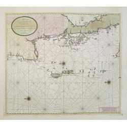
Afteekening van een gedeelte van de kust van Arracam, Pegu en Siam van de rivier Arracam, tot aan de Noordhoek van 't Eyland Sumatra.
Very rare chart of the Andaman Sea and Strait of Malacca. East to the top. In the top the town of Pegu in Myanmar is shown, than the chart follows the coast of Thailand t...
Place & Date: Amsterdam, 1753
Selling price: $4000
Sold in 2017