Browse Listings in Asia > Thailand / Burma / Vietnam
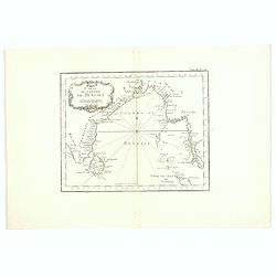
![[2 charts] Kaart van Pulo Condor, of het Eiland Condor.. / Paskaart van de Baay van Padaran op de Kust van Tsiompa..](/uploads/cache/31196-250x250.jpg)
[2 charts] Kaart van Pulo Condor, of het Eiland Condor.. / Paskaart van de Baay van Padaran op de Kust van Tsiompa..
Two finely engraved and detailed charts of Condor Island and the Bay of Pandaran near Vietnam.Latitude scale, compass rose and system of rhumb lines, soundings, anchorage...
Place & Date: Amsterdam, 1753
Selling price: $350
Sold in 2011
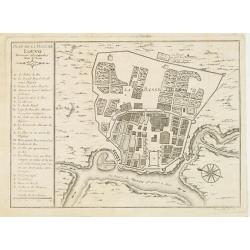
Plan de la ville de Louvo Demeure ordinaire des Rois de Siam.
From Prevost\'s Histoire des Voyages. Jacques Nicolas Bellin (1703-1772) was one of the most important and proficient French cartographers of the mid-eighteenth century. ...
Place & Date: Paris, 1757
Selling price: $50
Sold in 2008
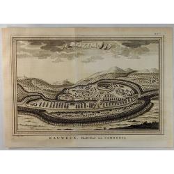
Eauweck Capitale de Camboye.
A highly detailed 1757 Bellin copper engraved panoramic view of the city of Lawec, Cambodia situated halfway along the Mekong River on the way to Phnom Penh. A new Lawec ...
Place & Date: Paris, 1757
Selling price: $99
Sold in 2019
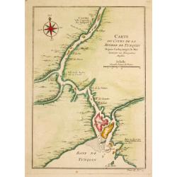
Carte du Cours de la Riviere de Tunquin.
Jaques Nicolas Bellin (1702-720) was the most important French hydrographer of the 18th century. Sea-atlas 'Hydrographique Français' , 1756-65, atlas to accompany Prévo...
Place & Date: Paris, c. 1760
Selling price: $75
Sold in 2009
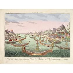
Vue de Siam avec diverses Sortes des Ballons, ou Vaisseaux Chinoise a rame.
So-called optical print illustrating a parade of vessels. Engraved by F.X. Habermann (1721-1796). The Academie Imperiale was a well-known publisher of optical prints, est...
Place & Date: Augsburg, 1760
Selling price: $600
Sold in 2014
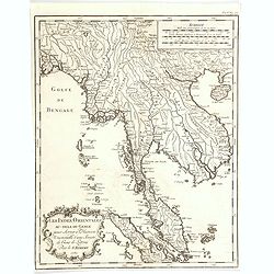
Les Indies Orientales au-dela Gange. . .
A nice map of Indo-China, taking in Burma, Thailand, Laos, Vietnam, Malaysia, Sumatra and Singapore. With good map detail, covering rivers, mountains, small islands, and ...
Place & Date: Paris, 1762
Selling price: $85
Sold in 2020
Carte du Golphe de Bengale.
An uncolored example of the Gulf on Bengal from Bellin's "Le Petit Atlas Maritime". Showing the island of Ceylon (Sri Lanka), the east coast of India, across in...
Place & Date: Paris, 1764
Selling price: $50
Sold in 2017
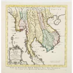
Carte Des Royaumes de Siam, de Runquin, Pegu. Ava..
Uncommon edition of this fine map incorporating information provided by French Jesuits, of Indochina, Malayan peninsular, Thailand, etc.From Atlas Portatif pour servir a ...
Place & Date: Amsterdam, 1773
Selling price: $380
Sold
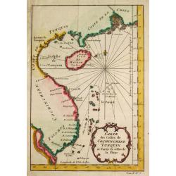
Carte des Costes de Cochin Chine, Tunquin et Partie de celles de la Chine.
Jaques Nicolas Bellin (1702-720) was the most important French hydrographer of the 18th century. Sea-atlas 'Hydrographique Français' , 1756-65, atlas to accompany Prévo...
Place & Date: Amsterdam, 1773
Selling price: $85
Sold
Carte Des Royaumes de Siam, de Runquin, Pegu. Ava. . .
Uncommon edition of this fine map incorporating information provided by French Jesuits, of Indochina, Malayan peninsular, Thailand, etc.From Atlas Portatif pour servir a ...
Place & Date: Amsterdam, 1773
Selling price: $350
Sold in 2021