Browse Listings in Asia > South East Asia > Java / Bali
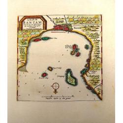
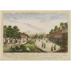
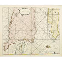
La Rade de Bantam.
Map of the Bay of Bantam on Java. Decorated with a frame cartouche. Pieter van der Aa (1659 - 1733) was a Dutch publisher best known for preparing maps and atlases. He a...
Place & Date: Amsterdam, 1732
Selling price: $49
Sold in 2014
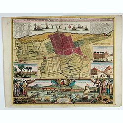
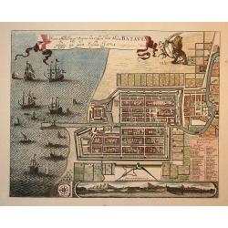
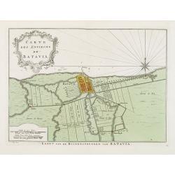
Der Hollaendisch-Ostindianischen Compagnie Weltberühmte Haupt - Handels und Niederlags stadt BATAVIA..
A very fine decorative plan of Batavia showing the City and its immediate environs, the surrounding rice fields intersected by a network of waterways, canals and outlying...
Place & Date: Nuremberg, 1733
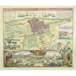
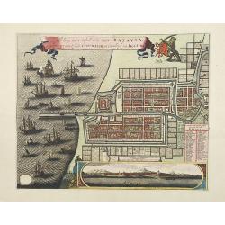
Der Hollaendisch-Ostindianischen Compagnie Weltberühmte Haupt - Handels und Niederlags stadt BATAVIA..
Very fine decorative town-plan of Batavia (Jakarta) showing the City and its immediate environs, the surrounding rice fields intersected by a network of waterways, canals...
Place & Date: Nuremberg, 1733
Selling price: $1600
Sold in 2012
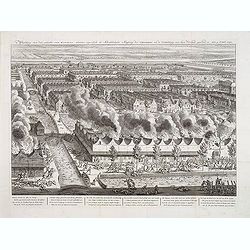
Afbeelding van dat gedeelte van BATAVIA, alwaar eigentlyk de Schrikkelyke Slagting der CHINEZEN, na de Ontdekking van hun Verraad, geshied is, den 9. Octob: 1740.
Very rare bird's-eye view of part of the city of Batavia, houses burning in foreground, canals filled with dead and drowning bodies and massacre of Chinese in progress on...
Place & Date: B. Mourik, after 1740
Selling price: $1000
Sold in 2013
Vue de la Bastion de Gelderland, hors de la Ville Batavia.
Complete title : Vuë de la bastion de Gelderland hors de la ville Batavie [mirror-reversed] / Collection des Prospects / Prospect von der Bastion Gelderland ausserhalb d...
Place & Date: Augsburg, 1740
Selling price: $400
Sold in 2010
Waere Affbeeldinge Wegens het Casteel ende Stadt Batavia Gelegen opt Groot Eylant Java.
Batavia (Jakarta), the Dutch capital in the East Indies, is an exquisite and detailed plan. The plan is based on Clement de Jonghe's map of 1650, except for a modificatio...
Place & Date: Amsterdam, 1740
Selling price: $1100
Sold in 2010
Afbeldinge van het casteel en de stadt Batavia. . .
Copied after Clement de Jonghe's map of 1650. Map of Jakarta, head quarters of the V.O.C.Joachim Ottens (1663 - 1719) and his sons Renier and Joshua were prominent Dutch ...
Place & Date: Amsterdam, 1740
Selling price: $2800
Sold in 2011
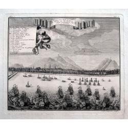
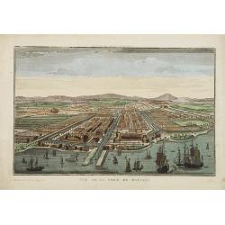
Ein Prospect der Stadt Batavia, wie sich dieselbe von der Reede oder dem Hafen praesentiret.
An uncommon view of Batavia (today known as Jakarta) shown from the sea, which was the main city of the Dutch East India Company (the VOC). The harbour is filled with sai...
Place & Date: Nuremberg, 1744
Selling price: $40
Sold in 2018
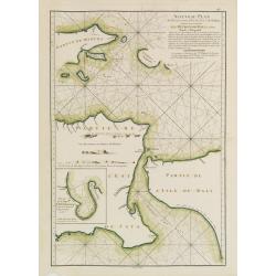
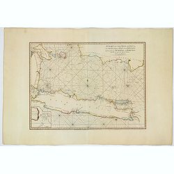
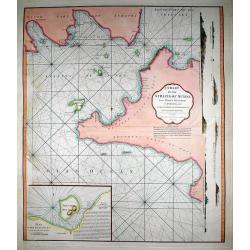
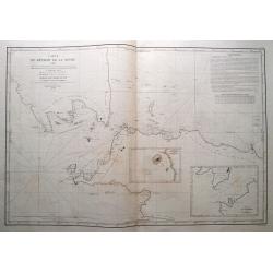
A large Draught of the East End of Java and Madura. . .
Oriented with west at the top, this large-scale and detailed chart of the Bali Strait and Java Sea, shows the eastern ends of Java and Madura, and the western end of Bali...
Place & Date: London 1745
Selling price: $400
Sold in 2023
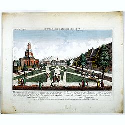
Prospect des Rathhauses in Batavia wie dasselbige auf dem grossen Platz nebst der um liegende Gegend (von fornen anzusehen).
A view of present-day Fatahillah Square in Jakarta. In the middle of the print the Raadhuis , headquarters of the VOC -nowadays the Jakarta museum-is clearly visible.
Place & Date: Augsburg, 1750
Selling price: $250
Sold in 2016
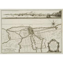
Carte des environs de Batavia avec la vuë de cette ville.
Map of Jakarta and surroundings with a separate view on top.From Prévost's important Collection of Voyages.
Place & Date: Paris, 1750
Selling price: $110
Sold
Insulae Java Pars Occidentalis Edente Hadriano Relando. . .
Second state of this finely engraved and detailed chart of Java important for its Dutch trading connections - annotated panels, clearly indicated rice fields, mountains, ...
Place & Date: Amsterdam, ca. 1753
Selling price: $2800
Sold in 2018
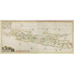
Insulae Java Pars Occidentalis Edente Hadriano Relando. . .
Very rare first state of this finely engraved and detailed map of Java important for its Dutch trading connections - annotated panels, clearly indicated rice fields, moun...
Place & Date: Amsterdam, 1753
Selling price: $5200
Sold in 2009
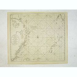
Pas-Kaaart van de Haven van Nangasequi.
A rare and finely engraved and detailed chart of Nagasaki.Latitude scale, compass rose and system of rhumb lines, soundings, anchorage's, etc.Very rare: only included in ...
Place & Date: Amsterdam, 1753
Selling price: $5500
Sold
Zee-Caart van het Eyland Sumatra Met de Straaten Malacca, Sincapoera, Banca en Sunda..
A rare and finely engraved and detailed chart of Sumatra important for its Dutch trading connections. In upper right corner a detailed depiction of southern tip of Malays...
Place & Date: Amsterdam 1753
Selling price: $4900
Sold
Insulae Iava Pars Occidentalis Edente Hadriano Relando..
Rare first state of this finely engraved and detailed map of Java important for its Dutch trading connections - annotated panels, clearly indicated rice fields, mountains...
Place & Date: Amsterdam 1753
Selling price: $3000
Sold
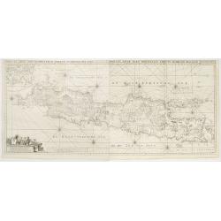
Insulae Java Pars Occidentalis Edente Hadriano Relando. . .
Second state of this finely engraved and detailed chart of Java important for its Dutch trading connections - annotated panels, clearly indicated rice fields, mountains, ...
Place & Date: Amsterdam, 1753
Selling price: $7000
Sold
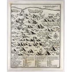
Carte du Chemin Entre Samarang et Cartasoera.
A highly detailed 1757 Bellin map depicting the Road between Semarang and Kartasuro in Java, Indonesia. Semarang is the capital and largest city of Central Java province ...
Place & Date: Paris, 1757
Selling price: $24
Sold in 2019
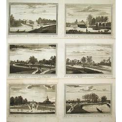
Vue de la Maison de Ville á Batavia / Vue de la Batterie Anjol / Vue du Fort Noortwyck en venant de Ryswyck / Vue du Fort noortwyck en venant de Jacatra / Vue de Poste Ryswyck / Vue du Fort Tangeran.
Jan van Schley is the engraver of the maps (by J.N. Bellin) and views in the Dutch edition of A.F. Prévost d\' Exile\'s \'Histoire Géneral des Voyages.A set of 6 engrav...
Place & Date: Amsterdam, 1759
Selling price: $350
Sold
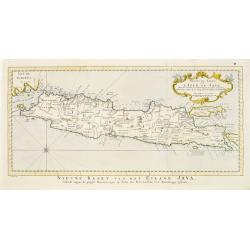
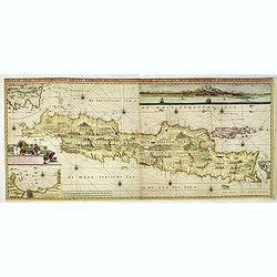
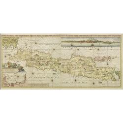
Nouvelle carte de l'Isle de Java.
A very nice map centered on the island of Java.With French text in title cartouche and an additional title in Dutch underneath the map.
Place & Date: Amsterdam 1773
Selling price: $200
Sold
Carte Des Environs de Batavia.
Uncommon edition of this fine plan of Batavia, head quarters of the V.O.C. In lower right engraved 13.From Atlas Portatif pour servir a l'intelligence de l'Histoire Philo...
Place & Date: Amsterdam, 1773
Selling price: $250
Sold in 2013
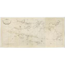
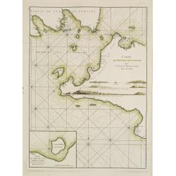
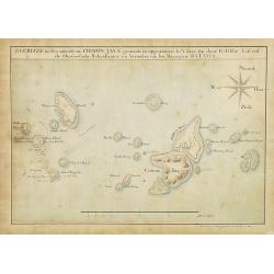
Nouveau Plan des Détroits, situés à l'Est de Java et de Madura, nommmés communément les Détroits de Bali et d'entre Pondi et Respondi..
French chart of straits of Bali. With eastern tip of Java, part of Madura and western tip of Bali. Inset chart of harbour of Ballembouang. The chart is giving credit to t...
Place & Date: Paris, ca 1775
Selling price: $190
Sold

Carte de l\'Isle de Java avec les Isles de Banca, de Biliton, et une partie de cellesd de Sumatra et de Bornéo.
French chart of the Island of Java, Banca, Billiton, and part of Sumatra and Borneo.Latitude and longitude scales, compass rose and system of rhumb lines, soundings near ...
Place & Date: Paris, ca 1775
Selling price: $400
Sold in 2008
Carte du Détroit de la Sonde depuis la Pointe de winerou jusqu'à l'Isle du Nord.Plan de la Baye de l'Ile de Mew ou Cantaye?
French chart of Sunda Street with the southeast cost of Sumatra and the western tip of Java.Latitude and longitude scales, compass rose and system of rhumb lines, soundin...
Place & Date: Paris, ca 1775
Selling price: $400
Sold in 2008
Carte de l'Isle de Java avec les Isles de Banca, de Biliton, et une partie de cellesd de Sumatra et de Bornéo.
French of the Island of Java, Banca, Billiton, and part of Sumatra and Borneo.Latitude and longitude scales, compass rose and system of rhumb lines, soundings near coast...
Place & Date: Paris, Brest, chez Demonville, 1775
Selling price: $180
Sold in 2013
Vue de la ville de Batavia.
A so-called optical print showing a bird's eye view of Batavia, Java (now Djakarta, Indonesia), the headquarters of the V.O.C. in Indonesia. In the foreground many Dutch ...
Place & Date: Paris, 1780
Selling price: $550
Sold in 2009
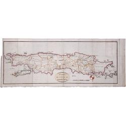
CARTE DE L'ISLE DE GRAND JAVA.
A scarce copperplate hand colored map of the island of Java. It shows the island upside down with the north to the bottom. Divided by regions with names of territories, s...
Place & Date: Paris, ca. 1780
Selling price: $130
Sold in 2020
A Chart of the Isle of Java, with the Islands of Banca and Billiton. . .
An English edition, published by Robert Sayer in London, of the Island of Java, Banca, Billiton, and part of Sumatra and Borneo. With an iInset part of Lubeck Island. Lat...
Place & Date: London, 1787
Selling price: $400
Sold in 2021
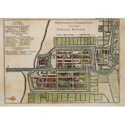
Grundriss von der Stadt und dem Schlosse Batavia.
From 'Algemeine Welthistorie (der Neuern Zeiten)'.
Place & Date: Halle, 1763-1792
Selling price: $150
Sold in 2017
A Chart of the Straits of Sunda, from Point Winerow to North Island...
SCARCE nautical from "The country East-India Pilot" published in 1799 by Laurie & Whittle. After D'Apres de Mannevillette's map from his Neptune Oriental. ...
Place & Date: London, 1794
Selling price: $55
Sold in 2011
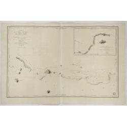
Zeereize in den omtrek van CRIMON JAVA gemaakt en opgenomen in 't jaar 1812 door G:Tibbe Lid van de Oostindische Rekenkamer en Verwalter van het Magazyn te BATAVIA.
Extremely well detailed and well-drawn manuscript map of Crimon Java Islands. To the left the track of the 1812 voyage by G.Tibbe is drawn. Map is in Dutch and all island...
Place & Date: Batavia, 1816
Selling price: $1275
Sold in 2014
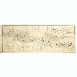
A map of Java chiefly from surveys made during the British administration, constructed in illustration of an Account of Java by T S Raffles . . ,
Rare and detailed map of Java to accompany his monumental two-volume History of Java published in 1817. The topography is particularly well represented, along with the lo...
Place & Date: Java, 1817
Selling price: $875
Sold in 2019
![[ Javanese people in local dress].](/uploads/cache/25842-250x250.jpg)
[ Javanese people in local dress].
Aquatint depicting Javanese people in local dress, in the center what look like a Dutch lady. Engraved by D.K. Bonatti, after drawings by C. Bottigella. Plate N° 51 From...
Place & Date: Milan, 1827
Selling price: $30
Sold in 2012
![[Batavia (Jakarta), view of V.O.C. warehouse. ]](/uploads/cache/25841-250x250.jpg)
[Batavia (Jakarta), view of V.O.C. warehouse. ]
Aquatint depicting workers preparing wood for shipping on the docks in Batavia. In the back ground a V.O.C. ware house, engraved by G.Castellini. Plate N° 50 From...
Place & Date: Milan, 1827
Selling price: $450
Sold in 2009
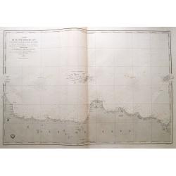
Carte de la Partie Nord-Ouest de' l'Ile de Java. . . Pl. 33. N° 1086.
Sea chart depicting the north west part of the Island of Java, up to Batavia (present-day Jakarta). Also an inset chart of part of the Java coast line.Prepared by Clémen...
Place & Date: Paris, 1839
Selling price: $500
Sold in 2022
Carte du détroit de la Sonde. . .
Fantastic large-scale sea-chart of the Sunda Strait with parts of Sumatra and Java. Includes Batavia (Jakarta), Telukbetung, and many small islands in great detail (Tabua...
Place & Date: Paris, 1846
Selling price: $255
Sold in 2014
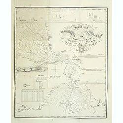
Kaart der vaarwaters van Soerabaya naar de trigonometrische opname van den Luit. ter Zee M.H. Jansen. . .
Chart of Surabaya the capital of the province of East Java. Prepared by Lieutenant M.H. Jansen (1817-1893) and improved in 1848 by baron P.Melvill de Carnbee. Engraved in...
Place & Date: The Hague, 1848
Selling price: $350
Sold in 2014
Verkenningen Genomen in de Wijnkoops-Baai.
A large so-called Blue-back chart of a part of Java, dated 1849, shows the results of local surveys in 1835-1849. No publisher mentioned (probably the Dutch Geographical ...
Place & Date: Jakarta, 1849
Selling price: $400
Sold in 2008
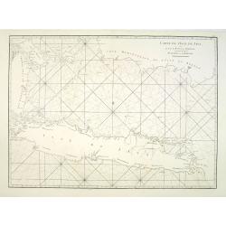
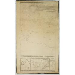
Carte de la côte nord de Java (de la pointe d'Intramayoe au détroit de Sourabaya). . .
Great large-scale sea-chart of a part of northern Java and the Java Sea. Shows the area from Indramayu to Surabaya, including Karimunjawa and Bawean. With numerous depth ...
Place & Date: Paris, 1850
Selling price: $62
Sold in 2014
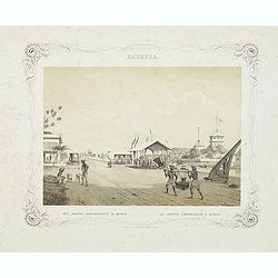
BATAVIA. Het jaagpad, landingsplaats te Batavia. Le jagpad, embarcadere à Batavia.
Rare lithographed view of the harbour of Batavia (Jakarta). Beautiful lithography drawn by Charles Theodore Deeleman (1823 - 1884), lithographed by G.J. Bos and printed b...
Place & Date: Batavia, 1859-1860
Selling price: $200
Sold in 2011