Browse Listings in Asia > South East Asia > Borneo
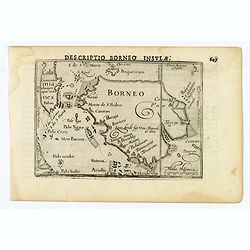
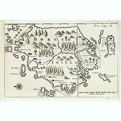
Descriptio Borneo Insula.
A miniature map of the Indonesian island of Borneo. Title is in bold capitals above the map. North is orientated to the left. The Equator runs through the southern part o...
Place & Date: Amsterdam, 1606
Selling price: $65
Sold in 2019
-250x250.JPG)
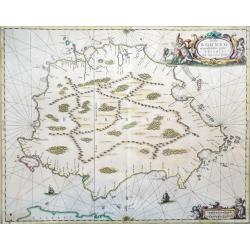
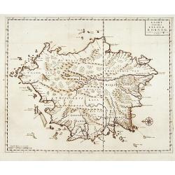
Insula Borneo et occidentalis pars Celebis cum adjacentibus insulis
Rare folio format map of the island of Borneo (Kalimantan) in Indonesia (with parts belonging to Malaysia and Brunei). North is on the right.This is the first large forma...
Place & Date: Amsterdam, 1659
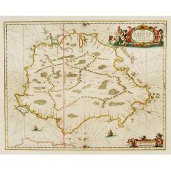
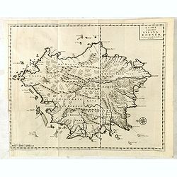
Insula Borneo et occidentalis pars Celebis cum adjacentibus insulis
Folio format map of the island of Borneo (Kalimantan) in Indonesia (with parts belonging to Malaysia and Brunei). North is on the right.This is the first large format map...
Place & Date: Amsterdam, 1659
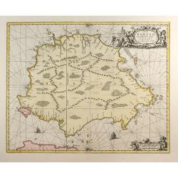
Insula BORNEO et occidentalis pars celibis cum adjacentibus Insulis.
An elegant map of Borneo. The map includes only coastal detail.The beautiful map is richly embellished with two fine cartouches featuring mermaids surrounding the scale o...
Place & Date: Amsterdam 1660
Selling price: $1105
Sold
Insula Borneo et Occidentalis Pars Celebis cum Adjacentibus Insulis
Reissue of Jansson map.
Place & Date: Amsterdam, c.1660
Selling price: $700
Sold in 2009
Borneo.
From a travel book deScribing the early Dutch voyages by René Augustin Constantin de Renneville Recueil des voiages qui ont servi à l'établissement & aux progrès ...
Place & Date: Amsterdam, E. Rogers, 1702
Selling price: $370
Sold in 2012
Kaart van het eyland Borneo.
Fine chart depicting the Island of Borneo. North is orientated to the left of the page.Little interior detail is given but the coastlines, settlements and principal coast...
Place & Date: Amsterdam 1724
Selling price: $400
Sold
Kaart van het eyland Borneo.
Fine map depicting the Island of Borneo. North is orientated to the left of the page. Little interior detail is given but the coastlines, settlements and principal coasta...
Place & Date: Amsterdam, 1726
Selling price: $950
Sold in 2015
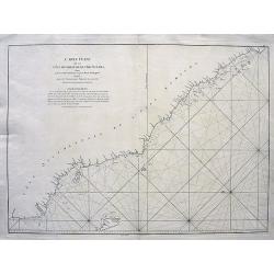
Carte Plate de la Cote Occidentale de l'Isle Sumatra depuis la Riviere de Touroumane jusqu'a la Pointe d'Indrapour...
Highly detailed and large sea-chart showing a part of the Sumatran westcoast. With numerous depth soundings and anchor places, showing even the smallest shoals, to help n...
Place & Date: Paris, c1775
Selling price: $200
Sold in 2008
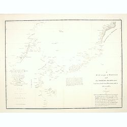
A Mar of part of Borneo and the Sooloo Archipelago: Laid down chiefly from observations made in 1761, 2,3, and 4.
Most important milestone based upon the surveys made from navigational surveys in 1761-64 by Alexander Dalrymple (1737-1808]. He was the first hydrographer of the Britis...
Place & Date: Paris, ca 1775
Selling price: $105
Sold in 2014