Browse Listings in Asia > Philippines
![Insulae Philippinae [Philippines].](/uploads/cache/42048-250x250.jpg)
Insulae Philippinae [Philippines].
A miniature map of Philippines, centered on Mindanao and Luzon. Title cartouche on the upper left corner. First published in 1598 in his Caert-Thresoor, the plates were e...
Place & Date: Middelburg, 1598
Selling price: $1500
Sold in 2018
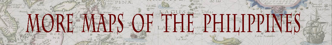
Descriptio Philippinarum / Insulae Philippinae.
A rare miniature map of Philippines. East is at the top. Title cartouche on the upper left corner.First published in 1598 in his Caert-Thresoor, the plates were executed ...
Place & Date: Amsterdam, Cornelis Claes, 1606
Selling price: $1075
Sold in 2016
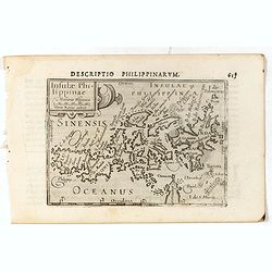
Insulae Philippinae.
This lovely miniature map shows the Philippine Islands. Published by Petrus Bertius, in Amsterdam at the beginning of the seventeenth century, this map is embellished wit...
Place & Date: Amsterdam, 1606
Selling price: $1550
Sold in 2019
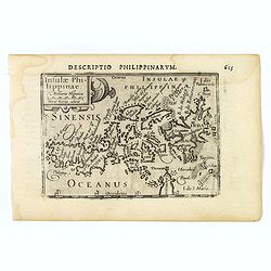
Insulae Philippinae.
A very rare map of the Philippines from 'Tresor des cartes…'; chapter: 'Les Philippines', 2 vols.; vol. 2, p. 55-56, French edition; published by A. Henry La Haye. T...
Place & Date: Amsterdam / Paris, 1606
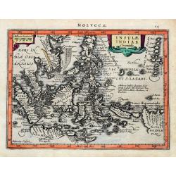
Insulae Indiae Orientalis.
An early and decorative map of South East Asia or Indochina. Shows Indonesia, the Philippines, Malaya, and a part of New Guinea. Filled with islands and names. Latin text...
Place & Date: Amsterdam, ca 1630
Selling price: $150
Sold in 2020
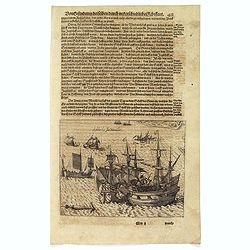
Schlacht for Manille.
Scarce print with German text sheet showing the Dutch anchored near Manila, the Spanish, with 7 soldiers to each Dutchman, tried to conquer the Dutch with their great bat...
Place & Date: Frankfurt, M.Merian, 1633
Selling price: $500
Sold in 2017
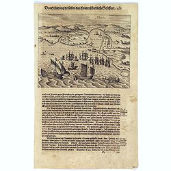
Manila.
Scarce print with German text sheet showing the harbour of Manila, carefully depicted here, is a good place for ships. The letter ‘A’ is the harbour itself. B: Shows ...
Place & Date: Frankfurt, M.Merian, 1633
Selling price: $800
Sold in 2017
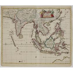
Tabula Indiae orientalis.
Detailed map of East Indies, the first of three maps of the East Indies that de Wit produced. It extending from Persia to northern Australia including the Philippine arch...
Place & Date: Amsterdam, 1662
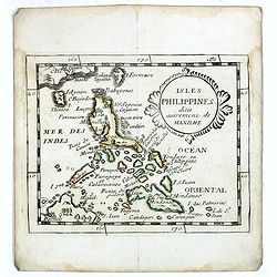
Isles Philippines dites autrement de Manilhe.
Uncommon miniature map of the Philippines, from Pierre Duval's La Geographie Universeille dated 1676.The fictitious island of San Juan (I. S. Iuan) appears in one of its ...
Place & Date: Paris, 1663
Selling price: $325
Sold in 2016

Les Iles Philippines. . .
Map of the Philippine Islands prepared by N.Sanson and published by Pierre Mariette.Published in an early edition of the small Sanson atlas L'Europe Dediée a M...
Place & Date: Paris, P. Mariette, 1667
Selling price: $250
Sold in 2009