Browse Listings in Asia > Philippines
![Insulae Philippinae [Philippines].](/uploads/cache/42048-250x250.jpg)
Insulae Philippinae [Philippines].
A miniature map of Philippines, centered on Mindanao and Luzon. Title cartouche on the upper left corner. First published in 1598 in his Caert-Thresoor, the plates were e...
Place & Date: Middelburg, 1598
Selling price: $1500
Sold in 2018
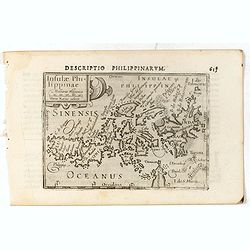
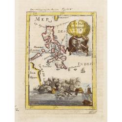
Descriptio Philippinarum / Insulae Philippinae.
A rare miniature map of Philippines. East is at the top. Title cartouche on the upper left corner.First published in 1598 in his Caert-Thresoor, the plates were executed ...
Place & Date: Amsterdam, Cornelis Claes, 1606
Selling price: $1075
Sold in 2016
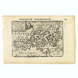
Insulae Philippinae.
This lovely miniature map shows the Philippine Islands. Published by Petrus Bertius, in Amsterdam at the beginning of the seventeenth century, this map is embellished wit...
Place & Date: Amsterdam, 1606
Selling price: $1550
Sold in 2019
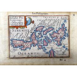
Insulae Philippinae.
A very rare map of the Philippines from 'Tresor des cartes…'; chapter: 'Les Philippines', 2 vols.; vol. 2, p. 55-56, French edition; published by A. Henry La Haye. T...
Place & Date: Amsterdam / Paris, 1606
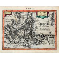
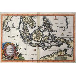
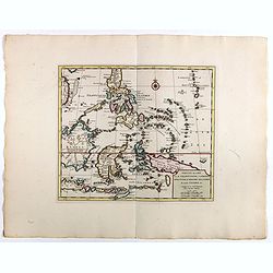
Insulae Indiae Orientalis.
An early and decorative map of South East Asia or Indochina. Shows Indonesia, the Philippines, Malaya, and a part of New Guinea. Filled with islands and names. Latin text...
Place & Date: Amsterdam, ca 1630
Selling price: $150
Sold in 2020
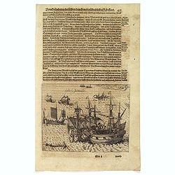
Schlacht for Manille.
Scarce print with German text sheet showing the Dutch anchored near Manila, the Spanish, with 7 soldiers to each Dutchman, tried to conquer the Dutch with their great bat...
Place & Date: Frankfurt, M.Merian, 1633
Selling price: $500
Sold in 2017
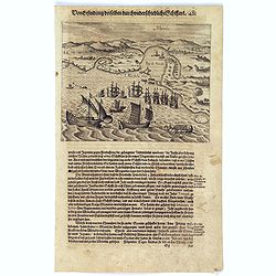
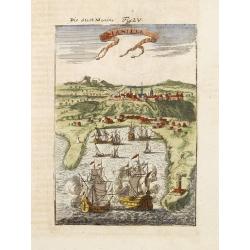
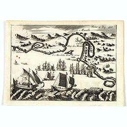
Manila.
Scarce print with German text sheet showing the harbour of Manila, carefully depicted here, is a good place for ships. The letter ‘A’ is the harbour itself. B: Shows ...
Place & Date: Frankfurt, M.Merian, 1633
Selling price: $800
Sold in 2017
Tabula Indiae orientalis.
Detailed map of East Indies, the first of three maps of the East Indies that de Wit produced. It extending from Persia to northern Australia including the Philippine arch...
Place & Date: Amsterdam, 1662
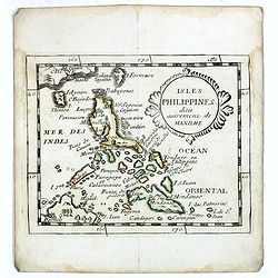
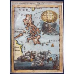
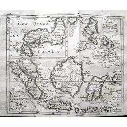
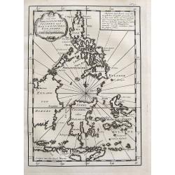
Isles Philippines dites autrement de Manilhe.
Uncommon miniature map of the Philippines, from Pierre Duval's La Geographie Universeille dated 1676.The fictitious island of San Juan (I. S. Iuan) appears in one of its ...
Place & Date: Paris, 1663
Selling price: $325
Sold in 2016

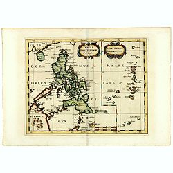
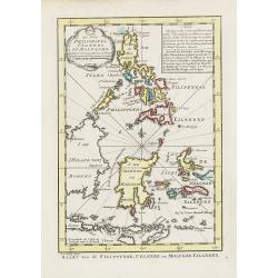
Les Iles Philippines. . .
Map of the Philippine Islands prepared by N.Sanson and published by Pierre Mariette.Published in an early edition of the small Sanson atlas L'Europe Dediée a M...
Place & Date: Paris, P. Mariette, 1667
Selling price: $250
Sold in 2009
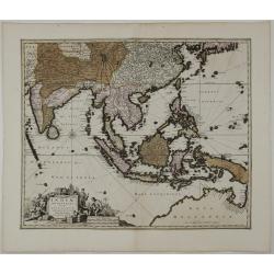
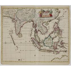
Indiae Orientalis nec non Insularum Adiacentium Nova Descriptio.
Detailed map of East Indies, extending from India to northern Australia. A decorative title cartouche, comprised of a carved stone block, surrounded by oriental figures, ...
Place & Date: Amsterdam, c. 1670
Insulae Philippinae (with inset of the Ladrones).
Fine example of this detailed map the Philippines, including a large inset map of the Ladrones. This is one of the earliest obtainable maps to focus on the Philippine isl...
Place & Date: Utrecht/Amsterdam, J.Halma, 1683
Selling price: $500
Sold in 2019
Les Isles Philippines 1684.
A charming late 17th century French map of the Philippines with a large pictorial cartouche depicting a mermaid with sea horses, a nautical sailing ship scene across the ...
Place & Date: Franckfurt 1684
Selling price: $125
Sold
Manille.
A charming late 17th century French bird's-eye view of Manila and its harbour. With a ribbon style title cartouche and a nautical sailing ship scene on the bottom.By Alla...
Place & Date: Franckfurt 1684
Selling price: $385
Sold
Les Isles Philippines 1684 - Die Philippinische Inseln
Uncommon map of the Philippines taken from '...Beschreibung des gantzen Welt-Kreyses..., das alte & neue Asia… [Description of the Entire Globe…Old and New Asi...
Place & Date: Frankfurt, ca. 1684
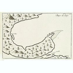
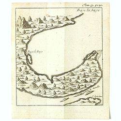
Baye la Baye.
Early map of Albay Bay on the Southeast Coast of Luzon, with the northern tip of Samar in the lower right. The mountains rising in the upper left lead to Mayon Volcano.Fr...
Place & Date: Amsterdam, E. Rogers, 1703
Selling price: $200
Sold in 2015
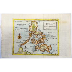
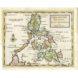
Philippine Islands. Agreable to Modern History
A fine map of the Philippines from 'Atlas Minor', vol. 1, p. 110, published in London. Herman Moll (c. 1654-1732) was one of the most important London mapmakers in th...
Place & Date: London, 1708
Insulae Indicae Cum Terris Circumvicinis.
Highly sought-after map of Southeast Asia. Includes today's Malaysia, Thailand, Vietnam, Singapore, Indonesia, Ceylon,< etc. Nova Hollandia (Australia) is depicted at ...
Place & Date: Munich, c1710
Selling price: $850
Sold in 2016
Les Isles Philippines, Molucques et de la Sonde.
Detailed map of the Philippines, Borneo and Indonesia. With an inset map of Japan. Names Singapore (Sincapura) and extends until Timor. The equator line is shown.
Place & Date: Paris, ca. 1710
Selling price: $135
Sold in 2019
![[Manilhas Bay]](/uploads/cache/15798-250x250.jpg)
[Manilhas Bay]
Fine chart depicting Manilla Bay. Little interior detail is given but the coastlines, settlements and principal coastal features are identified. An attractive early chart...
Place & Date: Amsterdam 1724
Selling price: $200
Sold
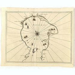
![[Lucon of Luconia]](/uploads/cache/15797-250x250.jpg)
[Lucon of Luconia]
Fine chart depicting the Islands of the Philippines. Little interior detail is given but the coastlines, settlements and principal coastal features are identified. An att...
Place & Date: Amsterdam 1724
Selling price: $650
Sold
![Lucon of Luconia. [ Map of the Philippines]](/uploads/cache/39345-250x250.jpg)
Lucon of Luconia. [ Map of the Philippines]
Fine chart depicting the Islands of the Philippines. Little interior detail is given but the coastlines, settlements and principal coastal features are identified. An att...
Place & Date: Amsterdam, 1724
Selling price: $2400
Sold in 2017
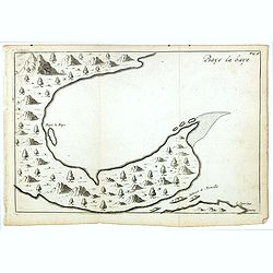
Baye la Baye.
Early map of Albay Bay on the Southeast Coast of Luzon, with the northern tip of Samar in the lower right. The mountains rising in the upper left lead to Mayon Volcano.Fr...
Place & Date: Amsterdam, F. Bernard, 1725
Selling price: $200
Sold in 2016
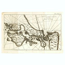
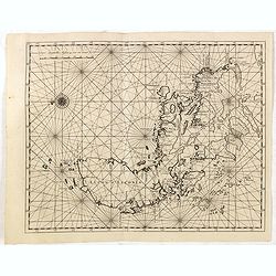
Typus freti Manilensis. Détroit de Manilles.
This is a scarce map of Southern Luzon and the Manila Strait. Includes the Islands of Kalusunan, Mindoro, Burias, Ticao, and Isla han Samar. Includes fleets of ships and ...
Place & Date: Rouen, Jean-Baptiste Machuel jr. 1725
Selling price: $700
Sold in 2017
Baye la Baye.
Early map of Albay Bay on the Southeast Coast of Luzon, with the northern tip of Samar in the lower right. The mountains rising in the upper left lead to Mayon Volcano.Fr...
Place & Date: Amsterdam, F. Bernard, 1725
Selling price: $180
Sold in 2018
Manila.
A rare and important early engraving of the Bay and city of Manila as visited by the Dutch fleet of Joris van Spilbergen in March 1616. The Dutch fleet are seen to be app...
Place & Date: Amsterdam, 1725
Selling price: $360
Sold in 2019
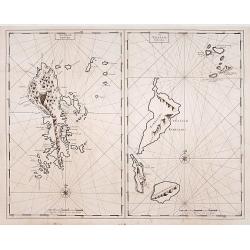
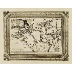
Het Eyland Sangir. / De Talautse Eylanden.
To the left map of the island of Sangir. To the right map of Talautse Islands.François Valentijn (1666-1727), a missionary, worked at Amboina from 1684 to 1694 and 1705 ...
Place & Date: Amsterdam 1726
Selling price: $100
Sold
(Philippine Islands)
Oriented to the east. The northern Philippines, showing all of Luzon.François Valentijn (1666-1727), a missionary, worked at Amboina from 1684 to 1694 and 1705 to 1713 a...
Place & Date: Amsterdam, 1726
Selling price: $1600
Sold in 2015
(Manilhas)
Untitled chart of Manila Bay [MANILHAS BAY] ... One of three maps and views of the Philippines published by François Valentijn (1666-1727), a missionary, who worked at A...
Place & Date: Amsterdam, 1726
Selling price: $1000
Sold in 2016
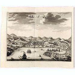
De Stad Manilhia.
A view of the city of Manila taken from the Bay. The view shows Intramuros, Cavite and churches then existing in the countryside around Manila at the beginning of the eig...
Place & Date: Amsterdam, 1726
Selling price: $950
Sold in 2016
De Manilles of Philippines Eylanden benevens de Moluccos, Macassar, Tymor en andere door P.W.Verhoeve aangedaan.
A beautifully engraved map of the area around the Philippines. Showing the track of the voyage by Pieter Willem Verhoeve.From Galerie Agréable du Monde, a sixty-six volu...
Place & Date: Leiden 1729
Selling price: $600
Sold
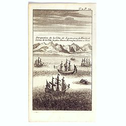
Perspective de la côte de Lucon pres de Manille a 6 lieues de la cote la plus haute montagne etant à l'est.
The print shows most likely Albay Bay on the Southeast Coast of Luzon with mountains risng in the back. Showing Dutch vessels in the foreground, likely those of Olivier v...
Place & Date: Paris / Amsterdam, ca 1730
Selling price: $375
Sold in 2017
Philippine islands Agreable to Modern History. . .
Map of the Philippines, with insets of Manila, Manila vicinity, Borneo. . .
Place & Date: London, c. 1732
Selling price: $975
Sold in 2011
Les Isles Philippines Moluques et de la Sonde.
A very nice map of Southeast Asia with the Philippines including Borneo, Java, Sumatra and the Moluccas, with an inset map of Japan. From Francisco Giustiniani for El Atl...
Place & Date: Leon de Francia (Lyon), Jaime Certa, 1739
Selling price: $450
Sold in 2021
Nieuwe kaart van de Filippynsche, Ladrones, Moluccos of Specery Eilanden als mede Celebes etc.
Shows the western islands of the archipelago, Borneo, Java and Sumatra, up to and including New Guinea. With very good detail to Philippines.Read more Early maps of South...
Place & Date: Amsterdam, 1740
Selling price: $350
Sold in 2018
![Plan de la baye de Manille capitale des isles Philippines située en l'isle Luçon [with] Plan de Pulo Condor ou Isle Condor située à l'extrémité orientale du golfe de Siam [and] Veue de l'Isle Condor. . .](/uploads/cache/39244-250x250.jpg)
Plan de la baye de Manille capitale des isles Philippines située en l'isle Luçon [with] Plan de Pulo Condor ou Isle Condor située à l'extrémité orientale du golfe de Siam [and] Veue de l'Isle Condor. . .
A first edition of the important and large French Sea chart including a chart of Manila Bay, Philippines, accompanied by a chart and view of Côn Son Island, Vietnam by J...
Place & Date: Paris, 1745
Selling price: $6200
Sold in 2017
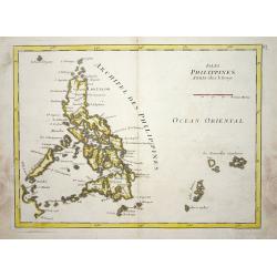
Isles Philippines.
Nice map of the Archipel des Philippines.
Place & Date: Paris 1748
Selling price: $100
Sold
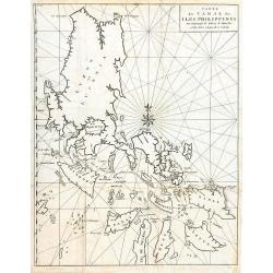
Carte du Canal des Iles Philippines par lequel Passe le Galion de Manille...
This large and detailed copper-engraved sea-chart, is one of the best obtainable maps of the Islands of the Philippines from the 18th century. It provides excellent detai...
Place & Date: Paris, ca. 1748
Selling price: $600
Sold in 2016
Karte von den Philippinischen Celebes und Molukkischen Eylanden.
Uncommon map of the Philippines, including a large part of Borneo, Sulawesi, the Moluccas, Bali, Timor, etc. With a small title cartouche and a box with German text.More ...
Place & Date: Paris, 1748
Selling price: $110
Sold in 2017
Carte des Isles Philippines Celebes et Moluques.
Uncommon issue of this map of the Philippines Islands, Borneo, Moluccas and Sulawesi.FromAtlas Portatif pour servir a l'intelligence de l'Histoire Philosophique et Politi...
Place & Date: Amsterdam, 1749
Selling price: $300
Sold in 2009