Browse Listings in Asia > Korea (and Japan)
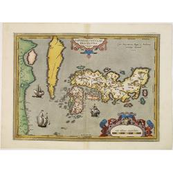
IAPONIAE INSULAE DESCRIPTIO. Ludoico Teisera auctore.
RARE in this perfect condition. The map was based upon the manuscript draft supplied to Ortelius in about 1592 by the famous official Portuguese chart maker, Luis Teixeir...
Place & Date: Antwerp, 1601
Selling price: $3500
Sold in 2017
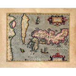
Japonia
One of the earliest views of Japan and Korea. This is a very attractive, boldly engraved map.The map is based on Abraham Ortelius' map which in turn was based on the ma...
Place & Date: Amsterdam, (1606) 1613
Selling price: $1150
Sold in 2011
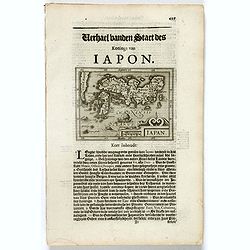
Iapan.
Small map of Japan, surrounded by text in Dutch. Nicolaes de Clerck (de Klerc) was active as engraver and publisher in Delft from 1599-1621.Included in the rare book : We...
Place & Date: Amsterdam, Cloppenburch, 1621
Selling price: $150
Sold in 2017
![IAPONIA, Petrus Kaerius Coelavit [Korea as an Island].](/uploads/cache/85228-250x250.jpg)
IAPONIA, Petrus Kaerius Coelavit [Korea as an Island].
An extremely rare variant of the map of Japan and Korea, based on Jodocus Hondius' folio map of Japan. The map follows the Ortelius/Teixeira type for Japan, with Korea sh...
Place & Date: Amsterdam,1676
Selling price: $600
Sold in 2021
![[Lot of 3 maps] Tabula Tartariae et Regni China.](/uploads/cache/100353-(2)-250x250.jpg)
[Lot of 3 maps] Tabula Tartariae et Regni China.
Frederick de Wit (1610-1698) became after the closing of the Blaeu firm one of the most important Amsterdam-based publishers. He published several atlases, Atlas Minor (1...
Place & Date: c. 1680
Selling price: $235
Sold in 2022
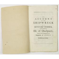
An account of the shipwreck of a Dutch vessel on the coast of the Isle of Quelpaert, together with the description of the kingdom of Corea. Translated out of French.
FIRST ENGLISH EDITION. A 26 page description extracted from the first edition of Churchill's "A Collection of Voyages and Travels: Some Now First Printed from Origin...
Place & Date: London, 1704
Selling price: $2600
Sold in 2011
Description geographique, historique, chronologique, politique, et physique de l'empire de la Chine et de la Tartarie chinoise.
First edition of this cornerstone of any collection of books on China, which is also among the rarest and most desirable of important Americana, included in Rare American...
Place & Date: Paris, P. G. Le Mercier, 1735
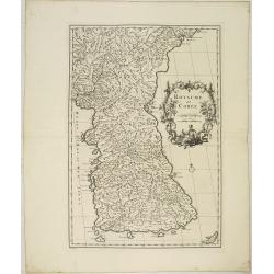
Royaume de Corée.
With a quite elaborately pictorial cartouche, engraved by G.Kondet. One of the earliest separate maps of Korea. Jean Baptiste Bourguignon d' Anville (1697-1782), French c...
Place & Date: The Hague, 1737
Selling price: $4000
Sold in 2010
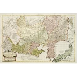
Carte Generale De La Tartarie Chinoise Dressee sur les Cartes Particulieres Faits Sur Les Lieux Par Les R.R. P.P. Jesuites . . . .MDCCXXXII
D'Anville is very important for Korean cartography as he made the cartography of Korea widely available. The map is the first fairly accurate western map of Korea, though...
Place & Date: The Hague, 1732-1737
Selling price: $1800
Sold
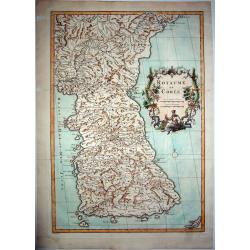
ROYAUME DE COREE.
The first separate map of Korea by a European cartographer. A fine engraved map of Korea, the title within a fine rococo historiated cartouche middle right, decorated wit...
Place & Date: Paris, 1737
Selling price: $3000
Sold in 2021