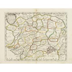
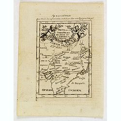
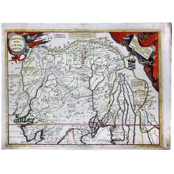
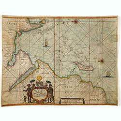
![[ Lot of 12 maps / views off India / Sri Lanka] Malabar.](/uploads/cache/20949-250x250.jpg)
[ Lot of 12 maps / views off India / Sri Lanka] Malabar.
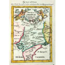
Attractive little map of the southern part of the Indian subcontinent, focusing on the Malabar coast from Goa to Cape Comorin and its important trading posts. Also depict...
Place & Date: Amsterdam, c. 1630
Selling price: $180
Sold in 2023
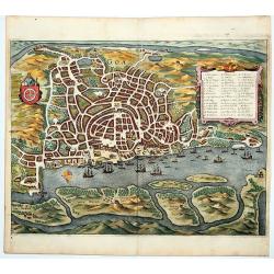
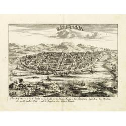
Goa
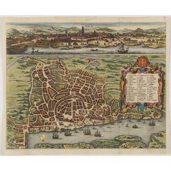
Beautiful birdeye view of Goa in India from Matthaus Merian. Showing the city at the beginning of the 17th century with many ships in the harbour and a cartouche describi...
Place & Date: Frankfurt, 1646
Selling price: $140
Sold in 2009
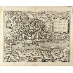
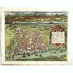
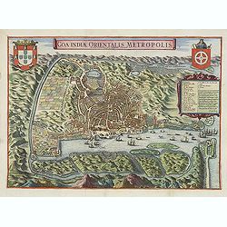
GOA.
This southern oriented map depicts the Portuguese colony of Goa, which is situated on the west coast of India and was a key port of trade for merchants. The map is very d...
Place & Date: Frankfurt, ca. 1646
Selling price: $285
Sold in 2020
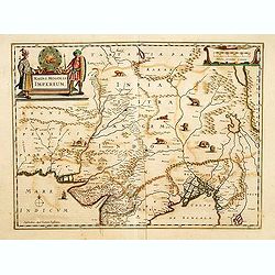
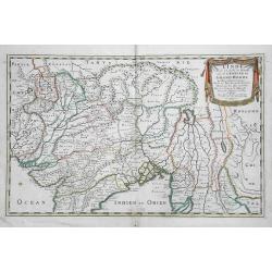
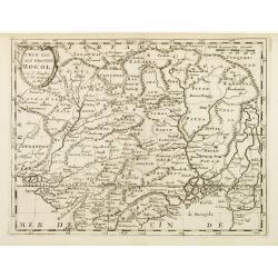
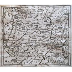
Magni Mogolis Imperium.
A most attractive map of northern India and Central Asia.
Place & Date: Amsterdam, 1650
Selling price: $150
Sold
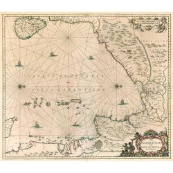
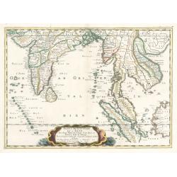
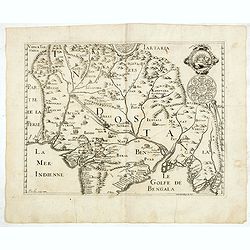
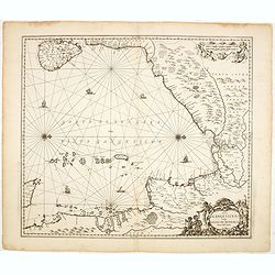
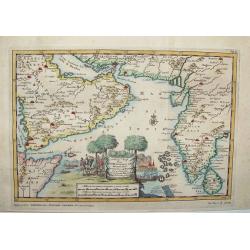
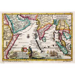
Sinus Gangeticus, Vulgo Golfo De Bengala. Nova descriptio.
Map of the Bay of Bengal, showing Ceylon, the east coast of India, the whole of Burma and the west coast of the Malay peninsula. Figurative cartouche and scale of miles. ...
Place & Date: Amsterdam 1650
Selling price: $600
Sold in 2010
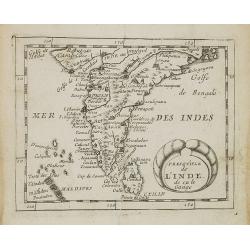
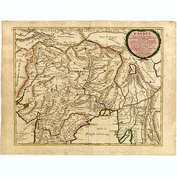
L'Inde decà et dela le Gange, ou est L'Empire du Grand Mogol.
An excellent mid 17th century map showing the area from Afghanistan and Pakistan in the west, and western China on the east, with most of India and extending north to the...
Place & Date: Paris, 1654
Selling price: $145
Sold in 2017
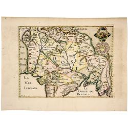
Partie meridionale de L'Inde En deux Presqu'Isles l'une deca et l'autre Gange
A superb example of Sanson's map of the Indian subcontinent and Southeast Asia. With the Dutch and English East India Companies being founded at the turn of the 17th maps...
Place & Date: Paris, 1654
Selling price: $160
Sold in 2023
Magni Mogolis Imperium.
An attractive map of the northern part of India, Tibet, Iran to Burma. The travel route from Kabul to Surat is the most prominent feature of the map. Richly decorated wit...
- $650 / ≈ €608
Place & Date: Amsterdam, 1658
The Mughal Empire. India/ Afghanistan. Description de la partie des Indes orientales qu est sous la domination du grand Mogol.
A very scarce, attractive map of the Mughal or Mogul Empire that at its height controlled much of India and Afghanistan from early in the 16th century; it gradually dwind...
Place & Date: Paris, 1663
Selling price: $260
Sold in 2019
L'Empire du Grand Mongol. . .
Map of the Northern part of India and the Mongol Empire prepared by N.Sanson and published by Pierre Mariette.Published in an early edition of the small Sanson atlas L'Eu...
Place & Date: Paris, P. Mariette, 1667
Selling price: $100
Sold in 2008
Presqu'isle de l'Inde. . .
Map of the Indian peninsula prepared by N.Sanson and published by Pierre Mariette.Published in an early edition of the small Sanson atlas L'Europe Dediée a Monseigneur ....
Place & Date: Paris, P. Mariette, 1667
Selling price: $220
Sold in 2008
Indes orientales ou Gange.
Rare map of South East Asia, including India, Malaysia, Philippines and Southern China, published by Jollain in 1667. Published in "Trésor Des Cartes Geographiques ...
Place & Date: Paris, 1667
Selling price: $500
Sold in 2018
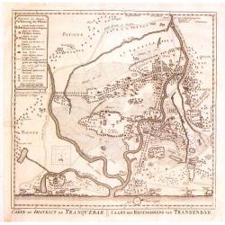
Carte du District de Tranquebar / Caart des Regtsgebieds van Trankenbar.
Fine detailed plan of the area around Trabquebar which is now Tharangambadi, India. This was a Danish trading colony in the state of Tamil Nadu.
Place & Date: Amsterdam, 1670
Selling price: $89
Sold in 2016

Goa.
A combined panoramic and bird's eye-town-plan of Goa, the main Portuguese trading post in India. From Philippus Baldaeus "Naauwkeurige Beschryvinge Van Malabar en Ch...
Place & Date: Amsterdam, 1672
Selling price: $600
Sold in 2008
Goa.
A combined panoramic and bird's eye-town-plan of Goa, the main Portuguese trading post in India. From Philippus Baldaeus "Naauwkeurige Beschryvinge Van Malabar en Ch...
Place & Date: Amsterdam, 1672
Selling price: $700
Sold in 2011
Description de la partie des Indes orientales qui est sous la domination du grand Mogol.
An early map showing the northern part map of part of India, centered on Agra, extending from Afghanistan to Bengal and from Tartary to the Deccan. Published from 1672 on...
Place & Date: Paris, 1672
Selling price: $246
Sold in 2015
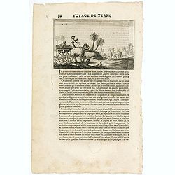
(Scene in India)
An early text engraving published from 1672 onwards in "Relations de Divers Voyages Curieux" by the French geographer, Melchisédech Thévenot. Thévenot's work...
Place & Date: Paris, 1672
Selling price: $3
Sold in 2015
Goa.
A combined panoramic and bird's eye-view of Goa, the main Portuguese trading post in India. From Philippus Baldaeus "Naauwkeurige Beschryvinge Van Malabar en Choroma...
Place & Date: Amsterdam, 1672
Selling price: $300
Sold in 2017
Presqu''isle de L'Inde de ça le Gange.
Uncommon miniature map of India from Pierre Duval's La Geographie Universeille dated 1676. Following his Cartes de geographie in 1657, Pierre Duval published this smaller...
Place & Date: Paris, 1676
Selling price: $40
Sold in 2008
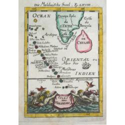
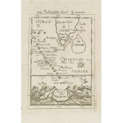
Isles Maldives.
Uncommon miniature map of the Maldives Islands from Pierre Duval\'s La Geographie Universeille dated 1676. Following his Cartes de géographie in 1657, Pierre Duval publi...
Place & Date: Paris, 1676
Selling price: $25
Sold in 2008
![Diu in Arabia. [Kathiawar - India]](/uploads/cache/07476-250x250.jpg)
Diu in Arabia. [Kathiawar - India]
View of the town of Diu / Kathiawar in India with in the foreground two spinning tops. With a verse in two languages underneath the picture.The poet Daniel Meisner from K...
Place & Date: Frankfurt, 1623-1678
Selling price: $50
Sold in 2008
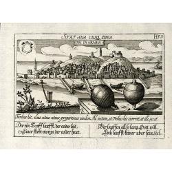
Diu in Arabia
Copper engraved view of Diu in India from D. Meisner "Sciographia Cosmica" printed 1638 in Nuremberg. With Latin and German aphorism.
Place & Date: Nuremberg, 1623-1678
Selling price: $90
Sold in 2010
![Diu in Arabia. [Kathiawar - India]](/uploads/cache/33435-250x250.jpg)
Diu in Arabia. [Kathiawar - India]
View of the town of Diu / Kathiawar in India with in the foreground two spinning tops. With a verse in two languages underneath the picture.The poet Daniel Meisner from K...
Place & Date: Frankfurt, 1623-1678
Selling price: $90
Sold in 2019
![Calechut in Indien. [India].](/uploads/cache/13804-250x250.jpg)
Calechut in Indien. [India].
A very nice picture representing the city of Calcutta. In the foreground, a musician riding a sea monster is depicted. With a verse in two languages underneath the pictur...
Place & Date: Frankfurt, 1623-1678
Selling price: $80
Sold in 2016
![Calechut in Indien. [India].](/uploads/cache/35641-250x250.jpg)
Calechut in Indien. [India].
A very nice picture representing the city of Calcutta. In the foreground, a musician riding a sea monster is depicted. With a verse in two languages underneath the pictur...
Place & Date: Frankfurt, 1623-1678
Selling price: $100
Sold in 2019
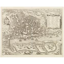
Goa.
A finely engraved, detailed plan of Goa. It also appeared in Gottfried?s Archontologia (1649). There is a cartouche identifying 43 buildings and the plan includes the har...
Place & Date: Frankfurt 1680
Selling price: $110
Sold
Goa.
A finely engraved, detailed town-plan of Goa, the main Portuguese trading post in India. It also appeared in Gottfried's Archontologia (1649). There is a cartouche identi...
Place & Date: Frankfurt, 1680
Selling price: $400
Sold in 2011
Sinus Gangeticus vulgo Golfo de Bengala Nova descriptio.
Showing the east coast of India and Sri Lanka. West to the top.
Place & Date: Amsterdam, 1680
Selling price: $175
Sold in 2014
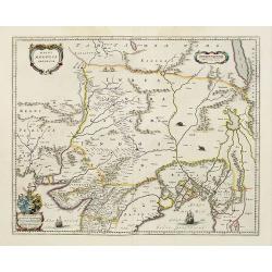
T\'Ryk van den Grooten Mogol.
An attractive map of northern India, and inner Asia, published by F.Halma.
Place & Date: Utrecht, 1682
Selling price: $120
Sold in 2010
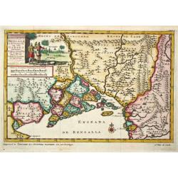
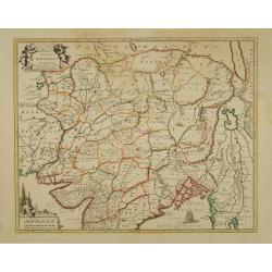
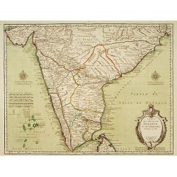
Landt caert vande Malabaer, Madura en Cormendel.
Detailed map of the southern tip of India and a part of Sri Lanka from Joan Nieuhof, "Gedenkwaerdige zee- en lantreize. . ."Decorative cartouches in the lower l...
Place & Date: Amsterdam, 1682
Selling price: $160
Sold in 2012
Partie de la Tere Ferme de l'Inde ou l'Empire du Mogol.
Alain Manneson Mallet (1603-1706) published in 1683 his ' Description de l' Univers' in 5 volumes. In 1686 a German edition appeared.
Place & Date: Paris, 1683
Selling price: $55
Sold
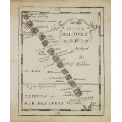
Isles de Maldives
Alain Manneson Mallet (1603-1706) published in 1683 his ' Description de l' Univers' in 5 volumes. In 1686 a German edition appeared.
Place & Date: Paris, 1683
Selling price: $55
Sold
Penisola dell India di là dal Gange. . .
Giacomo Rossi's fine late 17th century map of India and Ceylon. Issued in Il Mercurio geografico In lower right hand corner a large title cartouche.The cartographer was G...
Place & Date: Rome, 1683
Selling price: $500
Sold in 2015
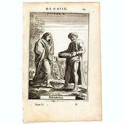
Bramins (de L'Asie / Figure L).
A fine and uncommon early 17th century miniature costume plate showing Brahmins from India.From the French text edition of Description d'Univers, 1683. by Allain Manneson...
Place & Date: Paris, 1683
Selling price: $30
Sold in 2016
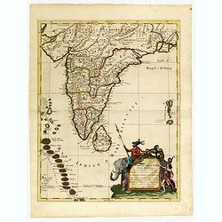
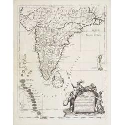
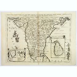
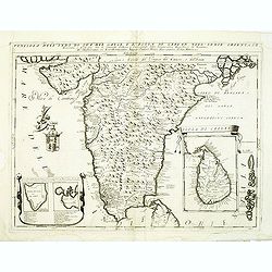
Penisola dell'India di qua dal Gange et Isole intorno ad essa adiacenti. DA GIACOMO CANTELLI DA VIGNOLA.
This is an uncommon map showing the southern part of India, with Sri Lanka and Maldives, from "Mercurio Geografico", published in Rome by G. de Rossi. A very ni...
Place & Date: Italy, 1683
Selling price: $950
Sold in 2020
Penisola Dell India di qua dal Gange. . .
A lovely, decorative map of India, Ceylon (Sri Lanka) the Maldive Islands, and surrounds, by Cantelli da Vignola, and published by Rossi in Rome. Plenty of good map detai...
Place & Date: Rome, 1683
Selling price: $375
Sold in 2020
Isles de Maldives.
A charming late 17th century French map of the Maldives Islands.From the German text edition published by Davis Zunners. Allain Manneson Mallet (1630-1706), a well travel...
Place & Date: Frankfurt, 1684
Selling price: $50
Sold in 2011
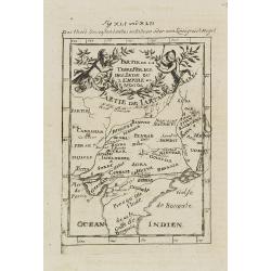
Partie de la Terre Ferme de l\'Inde ou l\'Empire du Mongol.
Map of India. From the German text edition published by Davis Zunners. Allain Manneson Mallet (1630-1706), a well traveled military engineer and geographer who worked in ...
Place & Date: Frankfurt, 1684
Selling price: $50
Sold in 2011
Partie de la Terre Ferme de l'Inde ou l'Empire du Mongol.
Map of India. From the German text edition published by Johann David Zunners of Frankfurt. Allain Manneson Mallet (1630-1706), a well traveled military engineer and geogr...
Place & Date: Frankfurt, 1684
Selling price: $50
Sold in 2020
Odia in Siam
Rare panoramic town-view of Bangkok, published in J.C. Wagner "Interiora orientis detecta, oder grundrichtige und eigentl. Bescheibung aller . . . Reiche des Orients...
Place & Date: Augsburg, Koppmayer,1686
Selling price: $280
Sold in 2011
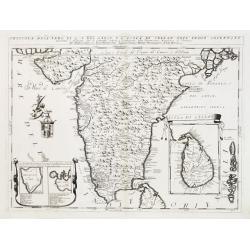
Penisola dell India di là dal Gange et Isole intorno ad essa adiacenti..
Giacomo Rossi's fine late 17th century map of India with Ceylon and Maldives. Issued in Il Mercurio geografico In lower right hand corner a large title cartouche with ded...
Place & Date: Rome, 1683-1688
Selling price: $2100
Sold
L'India. . .
Giacomo Rossi's fine late 17th century map of India. Issued in Il Mercurio geografico In upper right corner a tittle cartouche.
Place & Date: Rome, 1683-1688
Selling price: $500
Sold in 2015
![[Globe Gore of the Arabian Sea]](/uploads/cache/17783-250x250.jpg)
[Globe Gore of the Arabian Sea]
Originally engraved to be pasted onto a globe in 1688, this edition was printed with a text underneath it. It shows the Arabian Sea from Oman to Sri Lanka, with a roundel...
Place & Date: Venice 1690
Selling price: $300
Sold
Impero del Gran Mogol.
Northern India, with Pakistan, Bangladesh and the western part of Burma. In the top corners are cartouches for title and dedication, both with a martial theme. Engraved i...
Place & Date: Venice 1690
Selling price: $300
Sold
![[Globe Gore of the Arabian Sea]](/uploads/cache/26333-250x250.jpg)
[Globe Gore of the Arabian Sea]
Originally engraved to be pasted onto a globe in 1688, this edition was printed with a text underneath it. It shows the Arabian Sea from Oman to Sri Lanka, with a roundel...
Place & Date: Venice, 1690
Selling price: $450
Sold in 2011
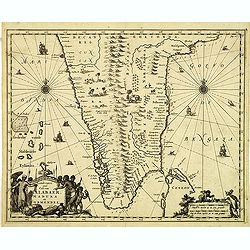
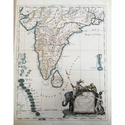
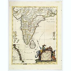
Penisola Dell' Indo di qua del Gange e L'Isola di Ceilan nell' Indie Orientale. . .
Coronelli's attractive double page copper engraved map of India below the Tropic of Cancer, with a pair of lovely insets of Trincomalee harbour and the island of Ceylon (...
Place & Date: Venice 1690
Selling price: $300
Sold in 2018
Impero del Gran Mogol.
Northern India, with Pakistan, Bangladesh and the western part of Burma. Including Cabulistan, Kandauna, Harduari, Binsola, Burchar, Kachemire, Iamba, Ragepor and others....
Place & Date: Venice, 1690
Selling price: $175
Sold in 2019
Impero del Gran Mogol.
Northern India, with Pakistan, Bangladesh and the western part of Burma. Including Cabulistan, Kandauna, Harduari, Binsola, Burchar, Kachemire, Iamba, Ragepor and others....
Place & Date: Venice, 1690
Selling price: $320
Sold in 2019
IMPERO DEL GRAN MOGOL.
A fine ,very rarely contempory colored ! map.Coronelli's maps are rarely to be found in contempory color ! From an Italian oldcolored composite atlas , otherwise usually ...
Place & Date: Venice, ca 1690
Selling price: $500
Sold in 2021
Penisola dell'Indo di qua del Gange, e l isola di Ceilan. . .
India below the Tropic of Cancer, with an insets of Ceylon and Trincomalee. Cartouche to the left depicts a Cherub holding a coat of arms.From Coronelli's rare Corso Geog...
Place & Date: Venice, 1692
Selling price: $210
Sold in 2012
Penisola dell'Indo di qua del Gange, e l isola di Ceilan..
India below the Tropic of Cancer, with an insets of Ceylon and Trincomalee.The remarkable Vincenzo Coronelli (1650-1718), encyclopaedist, geographer, inventor and Doctor ...
Place & Date: Venice 1698
Selling price: $475
Sold
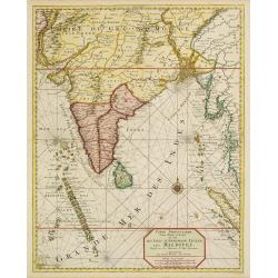
Carte particuliere d'une Partie d'Asie.. Ceylon, Maldives..
Intriguing map of India, Ceylon, Maldives and East Coast of Sumatra, and Malaysia. From Suite du Neptune François, ou Atlas Nouveau des Cartes Marines.From the rare and ...
Place & Date: Amsterdam 1700
Selling price: $2100
Sold
![[No title] [wall map of Southern India, Ceylon and part of Malaysia]](/uploads/cache/22782-250x250.jpg)
[No title] [wall map of Southern India, Ceylon and part of Malaysia]
An attractive large wall map of Southern India, Ceylon and part of Malaysia. Originally in 2 sheets, this is the bottom sheet.With 3 inset plans showing the surroundings ...
Place & Date: Paris, c. 1700
Selling price: $120
Sold
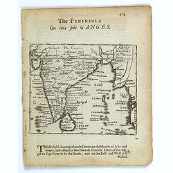
The Penisula on this side Ganges.
This map appeared in Modern's rare 'Atlas Terestris', first published in 1687. This map is the uncommon English text map of India, Ceylon, the Maldives and the Malaya Pen...
Place & Date: London, 1700
Selling price: $100
Sold in 2016
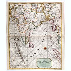
Carte particuliere d'une Partie d'Asie ou sont le Isles d'Andemaon, Ceylan, Les Maldives. . .
Intriguing map of India, Ceylon, Maldives and East Coast of Sumatra, and Malaysia. Sumatra peeks out of the eastern border, with the southwest peninsula showing the Kingd...
Place & Date: Amsterdam, 1700
Selling price: $700
Sold in 2020
Presqu Isle de L'Inde. deca la Gange.. .
Two maps together on one sheet.
Place & Date: Amsterdam, 1700
Selling price: $80
Sold in 2018
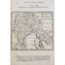
India or the Mogul's Empire.
A detailed map showing India, Sri Lanka, Tibet, Siam, Cambodia, etc. Names towns, rivers, and islands. With text below the map and on verso.
Place & Date: London, ca 1701
Selling price: $50
Sold in 2020
![Bandel, de Reede van de vermaerde Koopstadt Arrakan. [Chittagong]](/uploads/cache/32894-250x250.jpg)
Bandel, de Reede van de vermaerde Koopstadt Arrakan. [Chittagong]
View of Chittagong. From Schenk's Hecatompolis sive Totius Terrarum Oppida Nobiliora Centrum.. , a collection of 100 views, dedicated to the 14-year old Prussian crown pr...
Place & Date: Amsterdam, 1702
Selling price: $100
Sold in 2014
Mogol.
Detailed map of the Mughal Empire, which controlled much of South Asia by the early 18th century.
Place & Date: Paris, c.1704
Selling price: $20
Sold in 2013
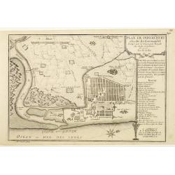
Plan de Pondichery la côte of Coromandel occupé pair la Compagnie Royale DES Indes cartographic Orientales..
Detailed plan of the town of Pondichery, by Nicolas De Fer, who was a royal French geographer.
Place & Date: Paris 1705
Selling price: $72
Sold
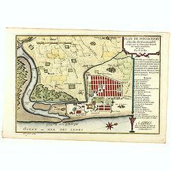
Plan de Pondichery la côte of Coromandel occupé par la Compagnie Royale des Indes cartographic Orientales..
Detailed plan of the town of Pondicherry, founded in 1674 as the capital of French India. A masterpiece of European Enlightenment Era urban planning, it was predicated on...
Place & Date: Paris, 1705
Selling price: $250
Sold in 2020
Scheep-Togt door Don Henrique de Menezes...
This is a desirable first state example of the Indian Ocean / India and Sri Lanka regions, from Van der Aa's NAAUKEURIGE VERSAMELING DER GENDENK-WAARDIGSTE ZEE EN LAND-RE...
Place & Date: Leiden, ca. 1707
Selling price: $325
Sold in 2008
Het Koninkrijk van Bengalen en de Vloeden die zig inde Ganges ontlasten.
Pieter van der Aa was a prolific publisher. He published a.o. ' Naaukeurige versameling der gedenkwaardigste zee- en land-reysen', a series of accounts of voyages (1706-0...
Place & Date: Leiden, 1707
Selling price: $225
Sold
Zee-Togt van Alfonso d' Albuquerque na de Roode Zee, d' Arabize en Persize Kusten, met die van Ormus, Guzaratte, Goa, Malacca en Verder Indien tot aan't Eiland Java.
Pieter van der Aa was a prolific publisher. He published a.o. ' Naaukeurige versameling der gedenkwaardigste zee- en land-reysen', a series of accounts of voyages (1706-0...
Place & Date: Leiden, 1707
Selling price: $550
Sold
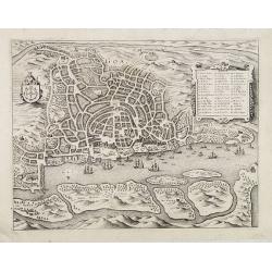
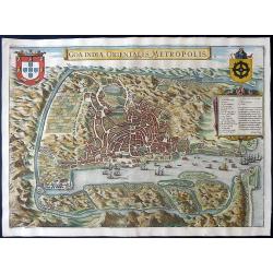
Goa Indiae orientalis metropolis.
A fine example of a rare plan of this important Indian city and port, the focal point for Portuguese trading activity in southern Asia. Pictorial map by Pieter Boudewyn v...
Place & Date: Leiden, 1719
Selling price: $600
Sold in 2015
![Carte nouvelle des Terres de Cucan. . . [India]](/uploads/cache/38871-250x250.jpg)
Carte nouvelle des Terres de Cucan. . . [India]
All the trading posts of the V.O.C. are marked with a flag. Prepared by H.Reland (1676-1718) a professor active in Utrecht and specialised in Asian languages, geography a...
Place & Date: Amsterdam, 1719
Selling price: $200
Sold in 2017
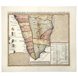
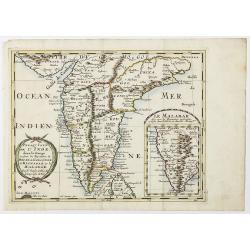
Carte Nouvelle des Terres de CUCAN, de CANARA, de MALABAR, de MADURA,m et de COROMANDL.
India south of Goa, from Chatelain's monumental 'Atlas Historique', published in Amsterdam. The map includes three text boxes giving particulars of the region and its div...
Place & Date: Amsterdam, 1719
Selling price: $75
Sold in 2019
Goa Indiae orientalis metropolis.
A decorative and detailed birds-eye view of the city and harbour of Goa. The map is based upon an earlier map by Jan Huygen van Linschoten. Linschoten served 6 years as t...
Place & Date: Leiden, 1719
Selling price: $450
Sold in 2020
La Ville de SURATTE, dans l'Empire du Mogol.
A copper engraving of Suratte, an important former trade post of the VOC, seen here with some VOC ships and local vessels in the foreground. From Pieter van der Aa's in &...
Place & Date: Leiden, 1719
Selling price: $120
Sold in 2020
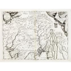
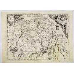
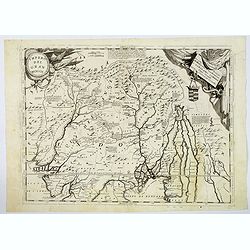
Magni Mogolis Imperium de novo correctum et Divisum..
A rare issue of this attractive map of northern India and Central Asia. The map was originally published by F.de Wit. P.Mortier acquired de Wit's stock of copperplates in...
Place & Date: Amsterdam 1720
Selling price: $300
Sold

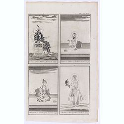
Jehan ou Jehon Gure, mort en 1627. / Gha Jehan ou Kourum, mort en 1665. / Oranzeb, mort en 1707. / Badour Siah, On ignore le tems de sa mort.
A striking and highly detailed copper engraved plate including 4 Indian Raja's Portraits. From Chatelain's 'Atlas Historique', 1732-1739. In upper right margin: 'Tom. V. ...
Place & Date: Amsterdam, 1720
Selling price: $36
Sold in 2011
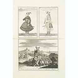
Jehan Darsiac. / Ferrog Sier. / Pompe & Ceremonie de la Marche du Grand Mogol.
From Chatelain's Atlas Historique, 1732-1739. In upper right margin: 'Tom. V. No 39. Pag: 110. Striking and highly detailed copper engraved plate including 2 Indian Raja'...
Place & Date: Amsterdam, 1720
Selling price: $30
Sold in 2016
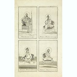
Tamberlan, mort en 1405. - Miracha ou Miraschae, mort en 1451. - Mohamed ou Miramont mort en 1451. - Abuchaid ou Abuzaid mort en 1469.
Striking and highly detailed copper engraved plate including 4 Indian princes or kings. From Chatelain's Atlas Historique, 1732-1739. In upper right margin: 'Tom. V. Nro ...
Place & Date: Amsterdam, 1720
Selling price: $47
Sold in 2014
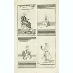
Sek ou Seich Omar, mort en 1493. Babar ou Baber ou Babour, mort en 1530. Amayum ou Houmayon, mort en 1552. Akebar ou Xa Aguebar, mort en 1605.
Striking and highly detailed copper engraved plate including 4 Indian princes or kings. From Chatelain's Atlas Historique, 1732-1739. In upper right margin: 'Tom. V. No 3...
Place & Date: Amsterdam, 1720
Selling price: $42
Sold in 2014
A chart of the Western Part of the East-Indies with all the Adjacent Islands from Cape Bona Esperanca to the Island od Zelone.
This scarce sea of the Indian Ocean from the Cape of Good Hope to the west coast of India (Malabar). First issued by John Seller, the present example published by Mount ...
Place & Date: London, Mount & Page, ca. 1720
Selling price: $1200
Sold in 2015
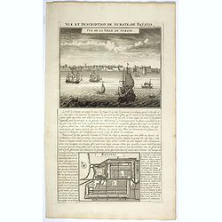
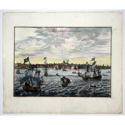
Vue et description de Surate et de Batavia.
In top a panoramic view of Surat, a port city in India previously known as Suryapur, with Dutch ships in the foreground. In bottom a plan of Jakarta (Batavia, 100 x 125mm...
Place & Date: Amsterdam, 1720
Selling price: $100
Sold in 2022
![[Four engravings showing People from India]](/uploads/cache/39592-250x250.jpg)
[Four engravings showing People from India]
Interesting sheet with four illustrations of different activities of people from India, from Chatelain's monumental 7 volume Atlas Historique. In upper right margin: 'Tom...
Place & Date: Amsterdam, ca. 1720
Selling price: $50
Sold in 2017
Sek ou Seich Omar, mort en 1493. Babar ou Baber ou Babour, mort en 1530. Amayum ou Houmayon, mort en 1552. Akebar ou Xa Aguebar, mort en 1605.
Striking and highly detailed copper engraved plate including 4 Indian Princes or Kings. From Chatelain's "Atlas Historique", 1732-1739. In upper right margin: '...
Place & Date: Amsterdam, 1720
Selling price: $35
Sold in 2018
![[Lot of 12 maps / views of India / Sri lanka]](/uploads/cache/IMG_2282-(1)-250x250.jpg)
[Lot of 12 maps / views of India / Sri lanka]
[A lot of 12 maps] views of India / Sri lanka.- Carte de la Baye de Trinquemale Ceylon (J. N. Belin) 1764- Carte Du Golphe De Bengale (J. N. Belin) 1746- Carte des...
Place & Date: Leiden, c. 1720
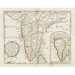
Carte des Cotes de Malabar et de Coromandel..
Detailed and attractive map of India and the northern tip of Sri Lanka. With decorative title cartouche and two compass-roses.
Place & Date: Paris, 1723
Selling price: $600
Sold in 2011