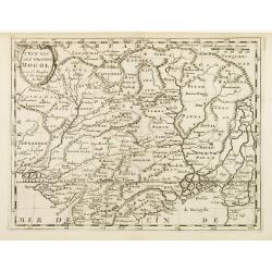
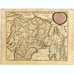
T\'Ryk van den Grooten Mogol.
An attractive map of northern India, and inner Asia, published by F.Halma.
Place & Date: Utrecht, 1682
Selling price: $120
Sold in 2010
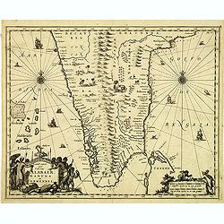
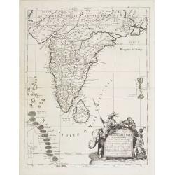
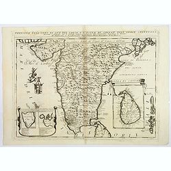
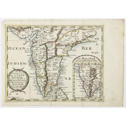
Landt caert vande Malabaer, Madura en Cormendel.
Detailed map of the southern tip of India and a part of Sri Lanka from Joan Nieuhof, "Gedenkwaerdige zee- en lantreize. . ."Decorative cartouches in the lower l...
Place & Date: Amsterdam, 1682
Selling price: $160
Sold in 2012
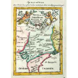
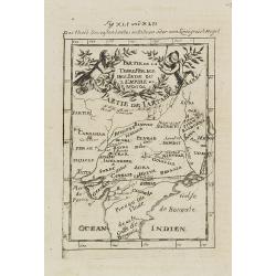
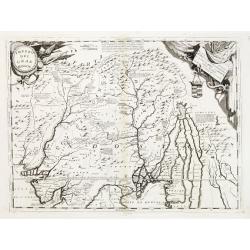
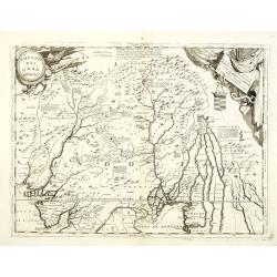
Partie de la Tere Ferme de l'Inde ou l'Empire du Mogol.
Alain Manneson Mallet (1603-1706) published in 1683 his ' Description de l' Univers' in 5 volumes. In 1686 a German edition appeared.
Place & Date: Paris, 1683
Selling price: $55
Sold
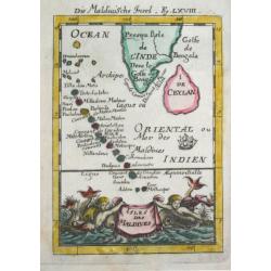
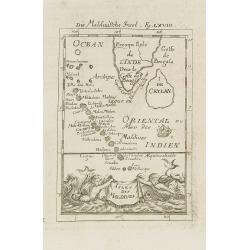
Isles de Maldives
Alain Manneson Mallet (1603-1706) published in 1683 his ' Description de l' Univers' in 5 volumes. In 1686 a German edition appeared.
Place & Date: Paris, 1683
Selling price: $55
Sold
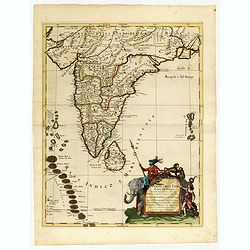
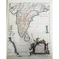
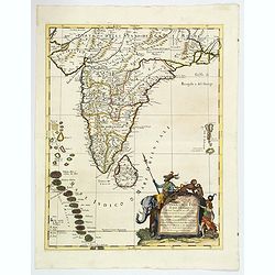
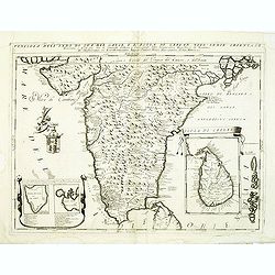
Penisola dell India di là dal Gange. . .
Giacomo Rossi's fine late 17th century map of India and Ceylon. Issued in Il Mercurio geografico In lower right hand corner a large title cartouche.The cartographer was G...
Place & Date: Rome, 1683
Selling price: $500
Sold in 2015
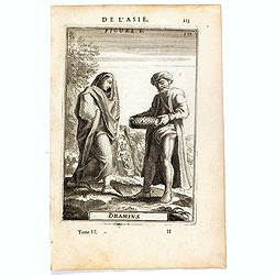
Bramins (de L'Asie / Figure L).
A fine and uncommon early 17th century miniature costume plate showing Brahmins from India.From the French text edition of Description d'Univers, 1683. by Allain Manneson...
Place & Date: Paris, 1683
Selling price: $30
Sold in 2016
Penisola dell'India di qua dal Gange et Isole intorno ad essa adiacenti. DA GIACOMO CANTELLI DA VIGNOLA.
This is an uncommon map showing the southern part of India, with Sri Lanka and Maldives, from "Mercurio Geografico", published in Rome by G. de Rossi. A very ni...
Place & Date: Italy, 1683
Selling price: $950
Sold in 2020
Penisola Dell India di qua dal Gange. . .
A lovely, decorative map of India, Ceylon (Sri Lanka) the Maldive Islands, and surrounds, by Cantelli da Vignola, and published by Rossi in Rome. Plenty of good map detai...
Place & Date: Rome, 1683
Selling price: $375
Sold in 2020
Isles de Maldives.
A charming late 17th century French map of the Maldives Islands.From the German text edition published by Davis Zunners. Allain Manneson Mallet (1630-1706), a well travel...
Place & Date: Frankfurt, 1684
Selling price: $50
Sold in 2011
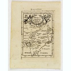
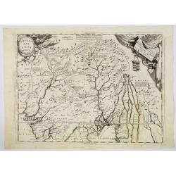
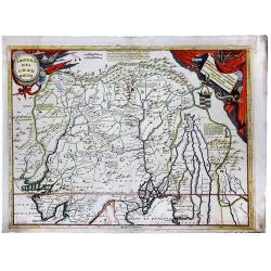
Partie de la Terre Ferme de l\'Inde ou l\'Empire du Mongol.
Map of India. From the German text edition published by Davis Zunners. Allain Manneson Mallet (1630-1706), a well traveled military engineer and geographer who worked in ...
Place & Date: Frankfurt, 1684
Selling price: $50
Sold in 2011
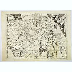
Partie de la Terre Ferme de l'Inde ou l'Empire du Mongol.
Map of India. From the German text edition published by Johann David Zunners of Frankfurt. Allain Manneson Mallet (1630-1706), a well traveled military engineer and geogr...
Place & Date: Frankfurt, 1684
Selling price: $50
Sold in 2020
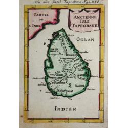
Ancienne Isle Taprobane.
Alain Manneson Mallet (1603-1706) published in 1683 his ' Description de l' Univers' in 5 volumes. In 1686 a German edition appeared.A map from Alain Manesson Mallet's 'D...
Place & Date: Paris, 1686
Selling price: $65
Sold in 2017
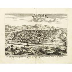
Odia in Siam
Rare panoramic town-view of Bangkok, published in J.C. Wagner "Interiora orientis detecta, oder grundrichtige und eigentl. Bescheibung aller . . . Reiche des Orients...
Place & Date: Augsburg, Koppmayer,1686
Selling price: $280
Sold in 2011
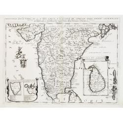
Penisola dell India di là dal Gange et Isole intorno ad essa adiacenti..
Giacomo Rossi's fine late 17th century map of India with Ceylon and Maldives. Issued in Il Mercurio geografico In lower right hand corner a large title cartouche with ded...
Place & Date: Rome, 1683-1688
Selling price: $2100
Sold
L'India. . .
Giacomo Rossi's fine late 17th century map of India. Issued in Il Mercurio geografico In upper right corner a tittle cartouche.
Place & Date: Rome, 1683-1688
Selling price: $500
Sold in 2015
![[Globe Gore of the Arabian Sea]](/uploads/cache/17783-250x250.jpg)
[Globe Gore of the Arabian Sea]
Originally engraved to be pasted onto a globe in 1688, this edition was printed with a text underneath it. It shows the Arabian Sea from Oman to Sri Lanka, with a roundel...
Place & Date: Venice 1690
Selling price: $300
Sold
Impero del Gran Mogol.
Northern India, with Pakistan, Bangladesh and the western part of Burma. In the top corners are cartouches for title and dedication, both with a martial theme. Engraved i...
Place & Date: Venice 1690
Selling price: $300
Sold
![[Globe Gore of the Arabian Sea]](/uploads/cache/26333-250x250.jpg)
[Globe Gore of the Arabian Sea]
Originally engraved to be pasted onto a globe in 1688, this edition was printed with a text underneath it. It shows the Arabian Sea from Oman to Sri Lanka, with a roundel...
Place & Date: Venice, 1690
Selling price: $450
Sold in 2011
Penisola Dell' Indo di qua del Gange e L'Isola di Ceilan nell' Indie Orientale. . .
Coronelli's attractive double page copper engraved map of India below the Tropic of Cancer, with a pair of lovely insets of Trincomalee harbour and the island of Ceylon (...
Place & Date: Venice 1690
Selling price: $300
Sold in 2018
Impero del Gran Mogol.
Northern India, with Pakistan, Bangladesh and the western part of Burma. Including Cabulistan, Kandauna, Harduari, Binsola, Burchar, Kachemire, Iamba, Ragepor and others....
Place & Date: Venice, 1690
Selling price: $175
Sold in 2019
Impero del Gran Mogol.
Northern India, with Pakistan, Bangladesh and the western part of Burma. Including Cabulistan, Kandauna, Harduari, Binsola, Burchar, Kachemire, Iamba, Ragepor and others....
Place & Date: Venice, 1690
Selling price: $320
Sold in 2019
IMPERO DEL GRAN MOGOL.
A fine ,very rarely contempory colored ! map.Coronelli's maps are rarely to be found in contempory color ! From an Italian oldcolored composite atlas , otherwise usually ...
Place & Date: Venice, ca 1690
Selling price: $500
Sold in 2021
Penisola dell'Indo di qua del Gange, e l isola di Ceilan. . .
India below the Tropic of Cancer, with an insets of Ceylon and Trincomalee. Cartouche to the left depicts a Cherub holding a coat of arms.From Coronelli's rare Corso Geog...
Place & Date: Venice, 1692
Selling price: $210
Sold in 2012
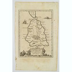
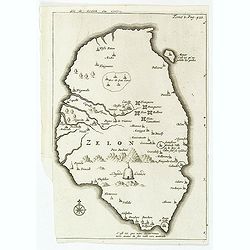
Taprobanae Insulae Descriptio ex Ptol. Incolae eidem Salae. . .
The uncommon and pleasant map of Taprobana (Sri Lanka) and the southern tip of India is based on the work of Ptolemy. It shows only ancient place names and is embellished...
Place & Date: Utrecht, ca 1695
Selling price: $60
Sold in 2020
Impero del Gran Mogol. . .
A beautiful and flamboyantly engraved large-scale map of Northern India at the time of the Mogul Empire. Also including Bangaledesh, Pakistan, Nepal and the Himalayas.The...
Place & Date: Venice, ca. 1696
Selling price: $400
Sold in 2012
Penisola dell'Indo di qua del Gange, e l isola di Ceilan..
India below the Tropic of Cancer, with an insets of Ceylon and Trincomalee.The remarkable Vincenzo Coronelli (1650-1718), encyclopaedist, geographer, inventor and Doctor ...
Place & Date: Venice 1698
Selling price: $475
Sold
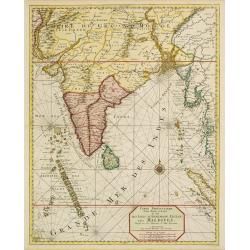
Carte particuliere d'une Partie d'Asie.. Ceylon, Maldives..
Intriguing map of India, Ceylon, Maldives and East Coast of Sumatra, and Malaysia. From Suite du Neptune François, ou Atlas Nouveau des Cartes Marines.From the rare and ...
Place & Date: Amsterdam 1700
Selling price: $2100
Sold
![[No title] [wall map of Southern India, Ceylon and part of Malaysia]](/uploads/cache/22782-250x250.jpg)
[No title] [wall map of Southern India, Ceylon and part of Malaysia]
An attractive large wall map of Southern India, Ceylon and part of Malaysia. Originally in 2 sheets, this is the bottom sheet.With 3 inset plans showing the surroundings ...
Place & Date: Paris, c. 1700
Selling price: $120
Sold
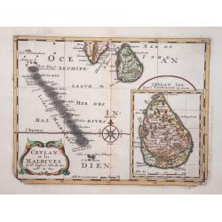
Ceylan, et les Maldives.
Exquisite map of Sri Lanka and the Maldives, with the southern tip of India shown at the top. Sri Lanka is shown in an inset named Ceylan Isle, qui est la Taprobane des A...
Place & Date: Amsterdam 1700
Selling price: $70
Sold in 2014
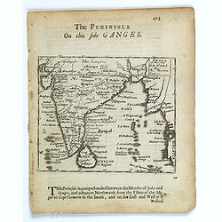
The Penisula on this side Ganges.
This map appeared in Modern's rare 'Atlas Terestris', first published in 1687. This map is the uncommon English text map of India, Ceylon, the Maldives and the Malaya Pen...
Place & Date: London, 1700
Selling price: $100
Sold in 2016
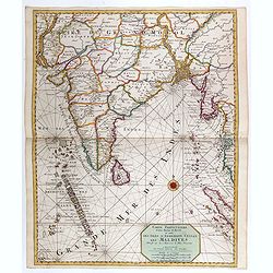
Carte particuliere d'une Partie d'Asie ou sont le Isles d'Andemaon, Ceylan, Les Maldives. . .
Intriguing map of India, Ceylon, Maldives and East Coast of Sumatra, and Malaysia. Sumatra peeks out of the eastern border, with the southwest peninsula showing the Kingd...
Place & Date: Amsterdam, 1700
Selling price: $700
Sold in 2020
Presqu Isle de L'Inde. deca la Gange.. .
Two maps together on one sheet.
Place & Date: Amsterdam, 1700
Selling price: $80
Sold in 2018
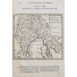
India or the Mogul's Empire.
A detailed map showing India, Sri Lanka, Tibet, Siam, Cambodia, etc. Names towns, rivers, and islands. With text below the map and on verso.
Place & Date: London, ca 1701
Selling price: $50
Sold in 2020
![Bandel, de Reede van de vermaerde Koopstadt Arrakan. [Chittagong]](/uploads/cache/24998-250x250.jpg)
Bandel, de Reede van de vermaerde Koopstadt Arrakan. [Chittagong]
From Schenk's Hecatompolis sive Totius Terrarum Oppida Nobiliora Centrum.. , a collection of 100 views, dedicated to the 14-year old Prussian crown prince, the later king...
Place & Date: Amsterdam, 1702
Selling price: $80
Sold in 2011
![Bandel, de Reede van de vermaerde Koopstadt Arrakan. [Chittagong]](/uploads/cache/32894-250x250.jpg)
Bandel, de Reede van de vermaerde Koopstadt Arrakan. [Chittagong]
View of Chittagong. From Schenk's Hecatompolis sive Totius Terrarum Oppida Nobiliora Centrum.. , a collection of 100 views, dedicated to the 14-year old Prussian crown pr...
Place & Date: Amsterdam, 1702
Selling price: $100
Sold in 2014

Baye de Matecalo Dans l'Isle de Ceyon / Partie du Golfe de Bengale.
Uncommon map of the Bay of Matecalo on Ceylon in the Gulf of Bengal. From the French reissue of the account of early Dutch voyages first published in 1608 by Commelin. Th...
Place & Date: Amsterdam, E. Roger, 1703
Selling price: $150
Sold in 2016
Isle de Zeilan ou Ceilon.
Uncommon map of Sri Lanka (Ceylon). From the French reissue of the account of early Dutch voyages first published in 1608 by Commelin. The French translation was carried ...
Place & Date: Amsterdam, E. Roger, 1703
Selling price: $225
Sold in 2012
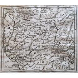
Mogol.
Detailed map of the Mughal Empire, which controlled much of South Asia by the early 18th century.
Place & Date: Paris, c.1704
Selling price: $20
Sold in 2013
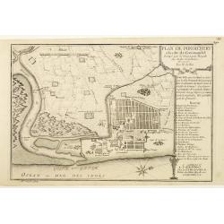
Plan de Pondichery la côte of Coromandel occupé pair la Compagnie Royale DES Indes cartographic Orientales..
Detailed plan of the town of Pondichery, by Nicolas De Fer, who was a royal French geographer.
Place & Date: Paris 1705
Selling price: $72
Sold
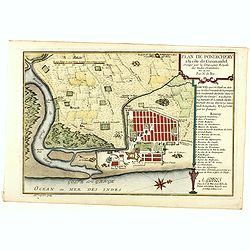
Plan de Pondichery la côte of Coromandel occupé par la Compagnie Royale des Indes cartographic Orientales..
Detailed plan of the town of Pondicherry, founded in 1674 as the capital of French India. A masterpiece of European Enlightenment Era urban planning, it was predicated on...
Place & Date: Paris, 1705
Selling price: $250
Sold in 2020